Limerick needs to be at the forefront of innovation when it comes to all section so society, be it sustainable transport, climate action, basic public relam, etc.
In order for this to happen...
Chapter 11: Development Management Standards
Closed26 Jun, 2021, 8:00am - 6 Sep, 2021, 5:00pm
Chapter 11 Development Management Standards
11.1 Introduction
In order to ensure the proper planning and sustainable development of Limerick, it is important that developments conform to the specific requirements set out in this chapter. This chapter should be read in conjunction with other relevant chapters and volumes in the Draft Plan.
Development management refers to the legal process followed by a Planning Authority to grant or refuse permission for development. Development refers to the carrying out of works, (to build, demolish or alter) on, in, over and under land or buildings and making significant changes to the use of land or buildings. Certain types/classes of development are exempted from requiring planning permission under Part II, Schedule 1 of the Planning and Development Regulations 2001 (as amended).
In all development proposals, particularly high-density residential development, it is the aim of the Planning Authority to promote a high level of amenity and quality design and to protect and complement existing amenities and character, in the interests of sustainable and orderly development. Unless otherwise stated, recommended residential and other development standards included in this chapter, are informed by a series of Section 28 Guideline documents.
11.1.1 Planning Process
Part 4 of the Planning and Development Regulations 2001 (as amended), sets out the statutory requirements with regard to submitting a planning application. Under the provisions of Article 22A, the Planning Authority may require an applicant to submit further information with any application to ensure that an informed decision can be made. Applicants are advised to consult with the Draft Plan maps together with the policies and guidance provided herein, in order to ascertain if there may be additional reports/details required.
Note the granting of permission by the Planning Authority does not necessarily enable the development to commence. There are other legal and procedural requirements to be satisfied, for example legislation under Building Control Acts, Public Health Acts, Fire Regulations and Environmental Pollution legislation.
The Planning Authority encourages applicants to avail of pre-planning meetings to discuss policy issues regarding their proposal prior to submitting a planning application. Section 247 of the Planning and Development Act 2000 (as amended) sets out the formal procedure to request such a meeting. It is of particular value to the applicant if specific assessments are required given the scale, sensitivity, type of development and location of the site. Refer to limerick.ie/council/services/pre-planning to avail of a meeting. Applicants are also advised to avail of pre-connection enquiries with Irish Water to ascertain if connection of water services (mains and sewer) is feasible for their proposals, prior to submitting a planning application.
There are many high level Government strategic policy documents on spatial planning, transport, climate adaptation and mitigation, energy efficiency, low carbon society and economy, digital connectivity, enterprise development, health, children’s play facilities, schools, heritage etc. that are also considered when assessing planning applications and formulating planning policy by Planning Authorities. Refer to gov.ie and the various sectoral departments.
The Office of the Planning Regulator (OPR) together with the Department of Housing, Local Government and Heritage (DHLGH) have published 14 leaflets to inform the public on the planning system, the Development Plan, applying for planning permission, appealing planning decisions, planning enforcement and planning applications in relation to agricultural and farm development, business, environmental assessments if required, architectural heritage, archaeology and Strategic Infrastructure Development. The Council strongly advises potential applicants/developers to avail of this guidance at: opr.ie/planning-leaflets/
11.1.2 Sustainability Statements
A Sustainability and Social Infrastructure Statement, which is an outline of the proposal’s context and addresses how it responds to Draft Plan objectives and surroundings, should be submitted for:
- 10 or more dwellings; or
- 500m2 gross of retail, commercial/office development in urban areas; or
- Enterprise and employment developments over 1,000m2 gross.
The statement should outline a justification for the development as proposed and any alternative design options considered. The statement should examine the impact of the proposal on social infrastructure. A design statement may be requested for other types of development at the discretion of the Planning Authority considering the sensitivity of the site (e.g. locations in scenic areas, or areas with protected view, elevated sites or in ACAs).
11.2 Residential Development - Design, Principles and Standards
This section sets out guidance on qualitative, quantitative and development management criteria for sustainable residential development that will form the basis for evaluating planning applications for residential development and their supporting infrastructure.
11.2.1 Design Criteria
The Council will be guided by current national policy documents and any subsequent national policy guidance in relation to planning within the lifetime of the Draft Plan. For additional information, refer to Chapter 3: Settlement and Housing Strategy, Chapter 10: Compact Growth and Revitalisation and Chapter 5 Environment, Heritage, Landscape and Green Infrastructure.
The following criteria will be taken into account when assessing applications:
- Land use zoning and specific objectives contained in the Draft Plan and Local Area Plan/Urban Framework Plan/non-statutory planning guidance adopted by the Council;
- Compliance with other policy requirements contained within the Draft Plan;
- Consistency with relevant National and Regional policy objectives;
- Interactions with adjoining complementary uses and land use zoning objectives;
- Development of brownfield sites, under-utilised and vacant sites is favored over greenfield proposals;
- Retention and refurbishment of existing structures, is favored over demolition and new build, where practical and reasonable;
- Density - higher densities should be provided in appropriate locations;
- The emphasis is on high quality in materials, design and appropriate landscaping;
- The quality of the residential environment will be of primary significance in determining the acceptability of planning applications;
- Context - having regard to the setting of the site, the surrounding character, streetscape and the impact of any proposed development on the development potential of adjoining sites;
- Layouts, elevations and plan form must be designed to reflect a ‘sense of place’ and community, utilising existing site features and enhanced landscaping;
- Levels of privacy and amenity, including consideration of overlooking, sunlight/daylight standards;
- Connectivity - quality of linkage, public realm/streets and permeability;
- Quality of proposed public, private and communal open spaces and recreational facilities;
- Accessibility and traffic safety - proximity to commercial centres and access to public transport;
- Quality and variety in layout in accordance with DMURS;
- Compliance with relevant quantitative standards;
- Variety of house types and unit size;
- Active frontages and passive surveillance will be encouraged;
- The quality of the noise environment that will be achieved, taking account of World Health Organisation and BS8233:2014 Guidance on Sound Insulation and Noise Reduction for Buildings recommended indoor and outdoor noise levels and the extent to which the principles of good acoustic design have been applied. The level of noise and vibration from construction and demolition activities assessed in accordance with BS 5228-1/-2:2009+A1:2014 Code of Practise for Noise and Vibration Control on Construction and Open Sites and the implementation of site mitigation measures where necessary;
- The management of air quality, including dust, during construction and demolition activities through the development of an Air Quality Management Plan and the implementation of site appropriate mitigation measure where necessary.
11.2.2 Design and Mix
Houses should be life adaptable to accommodate changing household sizes through the family lifecycle. Suitable design and mix is required across all new residential development.
- A detailed breakdown of the proposed unit type and size including a percentage split between 1/2/3+ bed units including site and/or floor plans that clearly identify proposed units. This should demonstrate accordance with the Housing Need Demand Assessment.
11.2.3 Density and Phasing
- Guidance for Residential density have been set out in Chapter 2: Core Strategy.
- A phasing schedule for any residential development exceeding 30 units, shall be submitted with a planning application.
11.3 Residential Development – General Requirements
11.3.1 Naming of Residential Estates
Place names are an important part of Limerick’s cultural heritage and reflect local history from ancient times to the present. The Council will seek that the naming of streets and residential estates shall reflect local place names or local people of note, heritage, language or topographical features as appropriate. The applicant/developer should ensure that the chosen place name for a new residential development is appropriate relative to its location and is not already in use within Limerick.
11.3.2 Management Companies and Taking in Charge
In residential developments, which are not proposed to be Taken in Charge by the Council, evidence will be required to show that private Management Companies will be in place by the time of completion of the estate (of which membership shall be compulsory for all purchasers of property).
If a development (or part thereof) is to be Taken in Charge by the Council, the applicant shall agree which areas are to be Taken in Charge and shall be clearly indicated on a site layout plan. All areas not to be ‘Taken in Charge’ by the Council, shall also be clearly indicated on a site layout plan and shall be maintained and be the responsibility of a properly constituted Private Management Company. These details shall be submitted with the planning application. All roads, cycle lanes, footpaths, sewers, drains, lighting columns, water mains, services and open spaces within the privately managed areas, irrespective of the management and maintenance regime to be put in place for these areas, shall be satisfactorily completed to the standard for development works as set out in the Council’s ‘Development Works Guidance Document’. In this regard, the applicant shall have regard to the Department of the Environment, Community and Local Governments document ‘Taking in Charge of Residential Developments Circular Letter PD 1/08’ and ‘Circular Letter PL 5/2014’ and the Council’s ‘Development Works Guidance Document’.
11.3.3 Bonds
To ensure the satisfactory completion of development works, such as roads, surface water drainage, public lighting and open space, including the protection of trees on a site, which has been the subject of a grant of permission, a bond or cash lodgement may be required until the development has been satisfactorily completed. The amount of such bond or cash lodgement will be determined by the Planning Authority.
11.3.4 Refuse Storage and Services
Adequate refuse storage, recycling and composting areas shall be catered for within all residential developments. In the case of communal refuse storage provision, the collection point for refuse should be accessible both to the external collector and to the resident and be secured against illegal dumping by non-residents. In the case of individual houses, the applicant shall clearly show within a planning application the proposed location and design of bin storage to serve each dwelling.
11.3.5 Roads, footpaths, water services and landscaping
Road and footpath design and construction shall be in accordance with DEHLG ‘Recommendation for Site Development Works for Housing Areas’ (1998) and design should also be informed by the Design Manual for Urban Roads and Streets, DTTS 2019 and any subsequent government guidance documents. Where there is a deviation in the general requirements, the primary consideration will be the safety of pedestrians, cyclists and access for emergency vehicles. Dished kerbs shall be provided at junctions and vehicular entrances, to facilitate people with ease of movement.
Pre-planning discussion with Irish Water is required for all residential estate development to ascertain feasibility of connection to the public mains and sewer. Each house shall have its own independent foul and surface water sewer connections to the main foul and surface water sewers. All sewers shall be located under roadways or open spaces. Water mains shall be located under footpaths where possible. Adequate separation between all utility mains (water/gas/sewer/electricity etc.) as required by the relevant authority shall be provided.
All service cables associated with the proposed development including electrical, communal television, telephone and street lighting cables shall be laid underground within the site. Refer to Section 11.7.4 Telecommunications, Broadband and Digital Connectivity and Section 11.10.2 lighting for additional requirements.
11.3.6 Open Space Requirements
Public open space is an integral part of any residential development. A variety of types and sizes of public open space should be provided with natural passive surveillance by the residents. Residential development should incorporate appropriate provision of quality public open space and play lots in accordance with national guidance and any subsequent guidance within the timeframe of the Draft Plan. Open space will be required as follows:
- Open space shall be cognisant of the principles of national guidance including accessibility, personal and child safety, linkage, place-making, public realm, permeability and the hierarchy of open space;
- In accordance with the 2009 Sustainable Residential Guidelines and any subsequent guidelines, at a minimum, 15% of the gross greenfield sites should be provided as multi-functional open space in new residential developments easily accessible to all, encouraging active and passive use for persons of all abilities regardless of mobility and/or age;
- In brownfield sites or infill sites, a minimum of 10% may be provided as public open space. Residential developments of 5 units or less may be exempt from the 15% open space provision on greenfield sites. The Council will determine on a case-by-case basis where it is demonstrated that the function of the space is not viable.
The Planning Authority will have regard to the following in the design and provision of open space:
- A reduction in open space may be considered for residential units in new housing estates located within 100m walking distance of a pocket park/play lot, small park, local park, urban neighbourhood park or regional park. Such facilities must be clearly delineated on planning application drawings and demarcated in advance of the sale of any of the units;
- Existing and proposed open space shall where possible be linked, providing green linkages/corridors for wildlife habitats and improving walking and cycling permeability through the site;
- A landscaping plan will be required for residential developments. Refer to Section 11.3.8 for additional information;
- Where a proposed development adjoins a river or canal bank, a linear walkway/cycleway access for the public may be required. The overall layout of the scheme will not compromise the future development of Blue/Green infrastructure proposals;
- Open space shall be appropriately sized to accommodate a range of open space activities. Both active and passive open space is required, functional and accessible to all;
- Provide for the retention of existing natural features;
- Include proposals for drainage and landscaping of the public open space;
- Houses shall not be permitted to back onto open spaces;
- Provide high levels of natural surveillance and overlooking by as many houses as possible.
Table DM 1: Open Space Hierarchy within Residential Estates:
|
Type of Public Open Space |
Area |
Accessibility from residential units |
Note
|
|
Play lot/pocket Park: primarily catering for play for younger children
|
400m2 – 0.2ha. |
Every home within 100m walking distance
|
All residential areas in excess of 50 units should incorporate a play lot provided at a rate of 4sqm per residential unit; Play lot should be overlooked with sufficient passive surveillance by as many houses as possible; Not permitted to side or rear of dwellings; Developer will be required to provide a minimum of two permanent play low maintenance features on site. The design shall reflect nature based play solutions. |
|
Small Park |
0.2 ha – 2 ha. |
Every residential unit within 400m walking distance
|
To accommodate a small playground with a minimum of 4 play features, kick around space and passive recreation; Must be overlooked with passive surveillance by as many houses as is practicable; Not permitted to side or rear of dwellings. |
|
Local Park |
2 ha. – 20 Ha. |
Residences to be within 1km
|
To accommodate a wide range of uses including playing pitches, teenage space, passive recreation and biodiversity areas. |
Note: Ancillary open space such as grass verges by roads, on edges of the site or corners in irregular site boundaries should not be included in calculations for the public open space provision on residential development layouts. Similarly, areas of archaeological interest shall not be included in the public open space calculation.
11.3.7 Private Open Space
The following is required as a minimum for new housing developments (excluding apartments and sheltered housing):
Front garden: Minimum length of 6m. where ground floor dwellings have little or no front gardens a ‘defensible space’ must be created behind the public footpath, such as a planting strip. Variation in building lines will be permitted where there is overall coherence to the design.
Rear Garden: Minimum 11m (22m back to back) garden depth will apply in order to protect privacy, sunlight and avoid undue overlooking. Reductions will be considered in the case of single storey developments and/or innovative schemes where it can be demonstrated that adequate levels of privacy, natural lighting and sunlight can be achieved.
All dwellings should have the minimum rear garden area as follows:
Table DM 2: Rear Garden Areas:
|
House Type |
Minimum rear garden areas (sqm.) |
|
1-2 bedroom |
48 |
|
3-5 bedroom |
60-75 |
|
Inner urban/infill dwellings/mews |
25 |
*Narrow strips of incidental open space to the side of houses should not be included in private open space calculations.
The above may be relaxed in exceptional circumstances such as:
- Where the development is within 10 minute walking distance of a public park or other amenity such as river bank/canal bank walkway/cycleway;
- The need to protect the established pattern of historic plot sizes of medieval streets;
- Innovate layout proposed in the development where the Council may consider it appropriate to accept a combination of the area of private and semi-private open space provision as satisfying the private open space provision of the dwellings.
Whilst, the above standards may be deviated from in instances of sheltered housing/accommodation and infill or backland development, the design should not compromise amenity of the residents. Any deviation from the above standards shall be accompanied by a written statement justifying the deviation and shall include mitigation/compensatory design features to ensure amenity is not compromised.
11.3.8 Landscaping
Landscape design and maintenance plans will form an integral part of all development applications. Landscape schemes must be in accordance with Limerick City and County Council’s standards for road and footpath layout. The design rationale shall identify how the overall approach is ecologically resilient and provides varied landscapes that reflect the character of the area. The landscape design rationale should also address the following:
- Biodiversity (including pollinator friendly approach) open spaces, especially large ones, can provide for a range of natural habitats and can facilitate the preservation and enhancement of flora and fauna. All proposals should be pollinator friendly, providing sufficient year-round diverse flowering plants to address the decline of pollinators. They should generally accord with the planting and maintenance approach set out in the Pollinator Friendly Planting Code of the All-Ireland Pollinator Plan, which is inclusive of best practise in the use of pesticides, herbicides, fungicides and growth regulators;
- Nature Based Play including cross-sections, where applicable, indicating the layout and hard and soft treatments of all boundaries, features, external areas and green spaces;
- Urban Greening;
- Specifications for materials together with proposed design detail to include, where applicable, any proposed lighting, seating, kerbing, boundaries, edging, surfacing and water features;
- Soft landscape details are to include detailed planting plans and planting schedules, stating species/varieties, quantities, sizes, rootball presentation and spacing;
- A Landscape Plan shall be accompanied with a timescale for its implementation, including a minimum 18-month landscape maintenance period and a defects liability clause;
- Sustainable Drainage Systems;
- Ecosystems services and carbon capture approach.
11.3.8.1 Hard Landscaping
Hard landscaping is an important element in any scheme and when designed correctly can visually enhance and help define the character of spaces, in addition to helping distinguish between areas for different transport modes. Hard landscaping shall address the following:
- Applications for substantial hard-surfaced areas must demonstrate methods of controlling and limiting surface water run-off consistent with sustainable development. These methods include use of permeable paving/surfaces, bio-retention areas and swales (which should be maintainable), such that rainfall is not directed immediately to surface water drains. Such methods can serve to reduce risk of flooding and help mitigate the impacts of climate change;
- Walls, fences, metal railings and gates used to define spaces should be selected so as to be an integrated part of overall design. Street furniture should be appropriately designed and sited such that it does not provide an obstacle for people with disabilities;
- Where underground or surface works are carried out, the Council will ensure the reinstatement of materials or the replacement with materials of similar style and quality.
11.3.8.2 Soft Landscaping
Key requirements in relation to site development and landscaping works include the following:
- Existing trees and vegetation (hedgerows) should be retained and incorporated into the landscaping of the site, where possible;
- Where a large site adjoins a green corridor, public open space or area of high ecological value, any new public open space on the site should be contiguous to same to encourage visual continuity and expansion of the green infrastructure/biodiversity network;
- Landscaping works should incorporate sustainable urban drainage systems such as biodiversity areas or wetlands, which can reduce surface water run-off. Green roofs, walls and permeable surfaces will be encouraged;
- The Council will encourage and promote tree planting in the planning and design of private and public developments. New tree planting should be planned, designed, sourced, planted and managed in accordance with ‘BS 8545:2014 Trees: from nursery to independence in the landscape – Recommendations’. New planting proposals should take account of the context within which a tree is to be planted and plant appropriate tree species for the location. A useful guide in this regard is the publication Conserving and Enhancing Wildlife in Towns and Villages, Heritage Council 2005 which contains a list of trees together with important information, such as eventual size and suitability to particular locations.
It will be a requirement of a planning permission that all planting takes place in the first planting seasons following occupation of the building or completion of the development, whichever is the sooner. Any trees or plants, which within a period of 5 years from the completion of the development die, or become seriously damaged or diseased shall be replaced in the next planting season.
11.3.9 Trees
The Council will seek the protection of existing trees when granting planning permission and the continued preservation and management of important trees, groups of trees and hedges as part of planning applications. Any proposals to remove mature trees shall be done as part of the planning application process, in order to prevent mature trees being removed on lands zoned for development, in advance of a planning application being submitted, where there is an intention to develop the lands. For applications where trees might be affected, the application should be prepared by a suitably qualified Arboriculturist, in accordance with British Standard 5837:2012 ‘Trees in relation to design, demolition and construction – Recommendations’ (this information may be helpful in pre-application consultations) and accompanied by the information below,
- Tree survey accompanied by a Tree retention/removal plan;
- Tree protection plan to include details of retained trees and Root Protection Areas (RPA) shown on the proposed layout;
- Arboricultural Impact Assessment;
- Arboricultural Method Statement.
All tree works associated with development must be carried out in accordance with British Standard BS 3998:2010 Tree Work Recommendations.
The following criteria shall be taken into account by the Council in assessing planning applications on sites where there are significant individual trees or groups/lines of trees, in order to inform decisions either to protect and integrate trees into the scheme, or to permit their removal:
- Habitat/ecological value of the trees and their condition;
- Uniqueness/rarity of species;
- Contribution to landscape, setting or streetscape;
- Significance of the trees in the context of the landscaping setting, views/vistas;
- The design of vehicular entrances shall avoid conflict with adjacent trees. Where a conflict is unavoidable and where a tree requires removal to facilitate a new or widened vehicular entrance, a financial contribution maybe required in lieu;
- Financial securities for trees: where a significant number of trees and hedgerows are to be retained, the Council will require a developer to lodge a financial security to cover any damage caused to them, either accidentally or otherwise as a result of non-compliance with agreed/specified on-site tree-protection measures. Types of securities include a cash deposit, an insurance bond or such other liquid asset as may be agreed between a developer and the Planning Authority. The security will be returned on completion of the development once it is established that the trees/hedgerows are in a satisfactory condition and have not been unnecessarily damaged by development works. Where damage occurs, the sum deducted from the tree security (or bond/other financial security) will be calculated in accordance with a recognised tree valuation system (e.g. CAVAT).
11.3.10 Boundary Treatment
Appropriate boundary treatment is an essential component of any development for private amenity and security, but also impacts on the visual amenity of a residential area and public realm. The following will be required of residential development boundary treatments:
- Rear boundaries for residential units shall have a minimum height of 1.8m – 2m and consist of capped, rendered concrete block/brick walls. Any wall visible from public road or open space shall be finished appropriately with suitable plaster or dash finish;
- Extensive lengths of boundary walls should not face onto the public thoroughfare. Design solutions should consider use of dual aspect dwellings and alternative site orientation including provision of side access/egress arrangements;
- Provision at a minimum of concrete post and concrete panel fencing as the side boundary between the flank side walls of houses;
- Where feasible, mature tree and hedge boundaries will be incorporated into the landscaping of a scheme. These boundaries are established biodiversity corridors and in some cases local historical value, defining local townlands.
11.3.11 SuDS (Sustainable Drainage Systems)
Urban development generally results in a high proportion of impervious surfaces, pavements, roadways, roofs etc. Adopting traditional methods of storm water runoff disposal can result in quantities of contaminated surface water run-off into the drainage network of sewers, culverts, stream and rivers which can cause both flooding and pollution locally in downstream catchments.
With this in mind, all new developments will be required to manage and minimise surface water runoff by the use of Sustainable Drainage Systems (SuDS), unless otherwise agreed with the Planning Authority. Previously developed sites which are being redeveloped should aim to achieve greenfield run off rates.
A comprehensive Storm Water Management Plan will provide an understanding of the mechanisms of surface water flooding and propose mitigation measures both at a local and strategic level. In this regard, cognisance shall be taken of guidance provided in the following documents: Department of the Environment, Heritage and Local Government ‘The Planning System and Flood Risk Management (Nov 2009 – Guidelines for Planning Authorities); CIRIA Manual C753 – The SuDS Manual (2015); Greater Dublin Strategic Drainage Study - GDSDS (2005) and current best practise.
The SuDS philosophy is to replicate, as closely as possible, the natural drainage from a site prior to its development and adopts the following four pillars of water quantity, water quality (including ground water protection), amenity and biodiversity.
Typical SuDS features to be considered on a site include, but are not limited to:
- Rainwater harvesting;
- Green roofs;
- Infiltration systems;
- Proprietary treatment systems;
- Filter strips and drains;
- Swales;
- Bioretention systems;
- Tree root systems;
- Pervious pavements;
- Ponds and wetlands;
- Detention basins.
- SuDS proposals shall be submitted as part of a planning application. In designing SuDS, developers should also consider the Taking in Charge policy of the Council. Applicants may also find the following sites useful as guidance in the development of their SuDS strategy: The UK SuDS website is also a useful site for information and provides some design tools for SuDs (uksuds.com).
In assessing proposals for surface water and SuDS schemes as part of any planning application, the Local Authority shall:
-
Require consideration of appropriate long-term storage (separate to attenuation storage and preferably with infiltration) for development runoff volume which is in excess of the greenfield runoff volume. Where long-term storage has been provided:
- Rainfall events up to the 1-year return period (RP) should discharge at the 1-year greenfield runoff rate;
- Events greater than the 1-year RP and up to the 30-year RP may discharge at the 30-year greenfield runoff rate;
- Events greater than the 30-year RP may discharge at the 100-year greenfield runoff rate.
- Where long-term storage cannot be provided, discharges from new developments must be controlled to a maximum of Qbar or 2 l/s/ha, whichever is the greater.
- Require demonstration that interception and/or treatment of surface water run-off is achieved in accordance with GDSDS policy and specifically requirements in respect of the first 5-10mm of run-off. Compliance with the above shall be demonstrated via the Simple Index Approach in the SuDS Manual (CIRIA C753).
- Require consideration of operation and maintenance of SuDS features. A schedule shall be submitted as part of any planning application defining future responsibilities.
- Ensure flow-restricting devices with an orifice of less than 50mm in diameter are avoided.
- Ensure surface water networks are designed for a 5-year rainfall return period with a minimum pipe diameter of DN225 (for Taking in Charge).
- Require percolation and infiltration tests prepared by an Engineer, with a minimum of €2m Professional Indemnity Insurance, are submitted as part of the assessment for SuDS proposals in any planning application. This test report should include details of infiltration tests and a plan showing test locations and datum of existing ground level. The report should also address groundwater depth encountered during the test period and include available information on local groundwater depths and direction of groundwater flow.
- Ensure groundwater protection measures are demonstrated where applicable.
- Ensure attenuation/storage of flow is designed for the 1 in 100-year return period with an allowance of 30% for climate change. There should be no flooding for the 1 in 30 year return period and no internal property flooding for the 1 in 100-year return period.
- Ensure an allowance of 10% is provided for urban creep.
- Ensure, depending on location and river flood levels, point-of-discharge systems are designed with a free outfall.
- Require redevelopment of previously developed sites to limit flows to the greenfield run off rate.
- Avoid use of concrete attenuation tanks.
- Require submission of a Stage 1 Stormwater Audit (see Appendix A for audit procedure) as part of any planning submission, a Stage 2 Stormwater Audit prior to construction and a Stage 3 Audit post construction. Stormwater Audits are required for both developments with a site area greater than 0.5 ha and for Strategic Housing Developments (SHD). For developments to be Taken in Charge, Stage Audits, including Limerick City and County Council approval of the audit and maintenance records will be required.
- Require surface water to be appropriately collected on site to prevent flow onto the public roadway, adjoining properties or into the public foul sewer. Exceedance flows shall also be considered.
- Ensure proposed parking and hardstanding areas shall be infiltrated locally, where underlying soil conditions are suitable for infiltration.
Ensure where basements have been proposed within the site, that they shall be protected by the ground being suitably profiled to prevent entry of overland flows.
Alternative SuDS proposals or requests for exemptions or partial exemptions will need to be agreed with Limerick City & County Council.
11.3.12 Noise
Excessive environmental noise can be harmful to the health and quality of life of individuals and communities in residential settings. The potential impact of transportation noise on occupants should be considered at the early stages of the planning process for new residential developments.
A key element in the design of new residential development should be the application of good acoustic design so that:
- Internal noise level guidelines, as outlined in BS 8233:2014, can be achieved with adequate building ventilation and thermal comfort, in all living areas (e.g. living rooms, bedrooms) with openable windows;
- Private external amenity areas can be enjoyed as intended, taking cognisance of environmental noise levels recommended not to be exceeded by the World Health Organization (WHO).
It is required that planning applicants, developers and their acoustic engineers apply the approach taken in the guidance document Professional Practice Guidance on Planning and Noise: New Residential Development (ProPG, 2017) and any other relevant guidance or best practice. The ProPG approach may also be applied to the design of other types of noise sensitive developments as well (e.g. educational facilities, hospitals, care homes).
The primary goal of ProPG is to ‘assist the delivery of sustainable development by promoting good health and well-being through the effective management of noise’. The guidance advocates a systematic, proportionate, risk based approach that facilitates straightforward accelerated decision making for lower risk sites and assists the proper consideration of noise issues, where the acoustic environment is more challenging.
Where noise is identified as an issue on a site, planning applications should be supplemented by an Acoustic Design Statement carried out by a suitably qualified person. . The Acoustic Design Statement should demonstrate that all facets of ProPG have been followed. Additional information on noise can be found in Section 5.3.11 in Chapter 5: Environment, Heritage, Landscape and Green Infrastructure.
11.4 Residential Development - Quality Standards
The provision and protection of residential amenities is a primary concern of Limerick City and County Council. It is the policy of the Council as outlined in the Draft Plan to ensure that new residential development is sufficiently flexible and adaptable to allow for changing circumstances and needs such as aging, disability and a growing family.
The standards for residential accommodation are divided into standards relating to apartments and houses (Section 11.4.1 and 11.4.2 respectively) and apply to new-build residential schemes. The minimum standards set within these sections will be sought in relation to refurbishment schemes however, it is acknowledged that this may not always be possible, particularly in relation to historic buildings, ‘living over the shop’ projects, tight urban infill developments and in the city under the Living City Initiative. In such cases, the standards may be relaxed subject to the provision of good quality accommodation and where the proposal secures the effective usage of underutilised accommodation.
11.4.1 Apartment Development
This section should be read in conjunction with Section 11.8.4, DM Table 8a/8b for car parking standards and Section 11.3.6 Open Space Requirements. In general, the design and layout of apartments shall comply with the Sustainable Urban Housing: Design Standards for New Apartments, Guidelines2020 and any future updates/amendments thereto.
11.4.1.1 Minimum Apartment Floor Areas
All apartment developments shall accord with or exceed the minimum floor areas indicated in the Sustainable Urban Housing: Design Standards for New Apartments, Guidelines for Planning Authorities (2020) below. In this regard, the areas listed are minimum standards and should not be taken as the norm for all developments, higher floor areas will be encouraged throughout Limerick.
Table DM 3: Minimum Overall Apartment Floor Areas:
|
Minimum Overall Floor Areas |
|
|
Studio |
37 m2 |
|
One bedroom |
45 m2 |
|
Two bedroom (3 persons) |
63 m2 |
|
Two bedroom (4 persons) |
73 m2 |
|
Three bedrooms |
90 m2 |
**In order to safeguard standards, the majority of apartments in any proposed scheme of 10 or more units shall exceed the minimum floor area standard for any combination of 1, 2 or 3 bed, by a minimum of 10% (excluding studios).
11.4.1.2 Dual Aspect Design
A dual aspect apartment shall be designed with openable windows on two or more walls, allowing for views in more than just one direction. The windows may be opposite one another, or adjacent around a corner. The use of canted windows on single external elevations is not acceptable to be considered dual aspect and these units, will be assessed as single aspect units. Specific Planning Policy Requirement (SPPR) 4 of the Sustainable Urban Housing: Design Standards for New Apartments, Guidelines for Planning Authorities (2020), provides guidance with respect to the minimum number of dual aspect apartments that may be provided in any single apartment schemes. In accordance with this guidance:
- There shall generally be a minimum of 50% dual aspect apartments in a single scheme.
- For building refurbishment schemes on sites of any size or urban infill schemes on sites of up to 0.25ha, Limerick City and County Council may exercise discretion to consider dual aspect unit provision at a level lower than the 50% minimum outlined above on a case-by case basis, but subject to the achievement of overall high design quality in other aspects.
11.4.1.3 Separation between Blocks
All residential development, particularly apartment developments and those over three storeys high, shall provide for acceptable separation distances between blocks to avoid negative effects such as excessive overlooking, overbearing and overshadowing effects and provide quality living environment for future occupiers.
In general a minimum separation distance of 22 m. is required between opposing windows in the case of apartments up to three storeys in height. In taller blocks, a greater separation distance may be required having regard to the layout, size and design. In some cases, subject to design, orientation and location in built-up areas, reduced separation distances may be acceptable. In all instances where the minimum separation distances are not met, the applicant shall submit a sunlight/daylight/overshadowing analysis for the proposed development.
11.4.1.4 Internal Storage and External Storage
Internal storage standards for apartments shall comply with the following:
- Minimum Storage Space Requirements:
- One Bedroom: 3m2
- Two Bedroom (3 person): 5m2
- Two Bedroom (4 person): 6 sq. m.
- Three Bedroom: 9m2.
- Storage should be additional to kitchen presses and bedroom furniture.
- Hot press/boiler space will not count as general storage.
- No individual storage room should exceed 3.5m2 and shall be provided within the apartment unit.
In addition to the minimum apartment storage requirements, apartment schemes should provide external storage for bulky items outside individual units (i.e. at ground or basement level). These storage units should provide for accessible and secure storage, allocated to each individual apartment unit. Each storage room shall provide appropriate electric points for the purpose of charging electric bikes/scooters. Each storage room shall provide appropriate electric points for the purpose of charging electric bikes/scooters.
11.4.2. Residential Quality Standards – Houses
11.4.2.1 Separation Distances between Residential Units
As per the 2009 Sustainable Residential Guidelines, in the interest of residential amenity the following applies:
- A minimum of 22m separation distance between directly opposing rear windows at first floor level in the case of detached, semi-detached and terraced units;
- Any residential development proposal exceeding three or more storeys shall demonstrate adequate separation distances having regard to occupier’s amenity including privacy, sunlight and daylight. Each development proposal will be assessed on a case-by-case basis and should not be seen as a precedent for future development in the area;
- Minimum 3m separation distance to the side of dwellings for the full length of detached, semi-detached or end of terrace dwellings, equally divided between the two adjacent dwellings.
Note: These separation distances may be deviated from in the case of infill and brownfield development offering opportunities for regeneration and bringing use to under-utilised lands. The developer shall submit a statement demonstrating design mitigation with respect to impact on residential amenity.
11.4.2.2 Floor Areas
The minimum size of habitable rooms for houses shall conform with national guidelines/standards in operation at the date of application for planning permission, including the minimum dimensions as set out in Sustainable Urban Housing: Design Standards for New Apartments Guidelines for Planning Authorities (2020) and Quality Housing for Sustainable Communities: Best Practice Guidelines for Delivering Homes Sustaining Communities (2007).
11.4.2.3 Aspect and Natural Light
As a standard, all habitable rooms within new residential units shall have access to appropriate levels of natural/daylight and be guided by the principles of Site Layout Planning for Daylight and Sunlight, A guide to good practice (Building Research Establishment Report, 2011) and/or any updated guidance. A daylight analysis will be required where considered necessary.
11.4.3 Serviced Sites
Serviced sites refer to a number of individual residential plots of not less than 0.1 ha with access to services such as utility connections, paths, lighting and within walkable distance of town or village centres, close to the urban core. Serviced sites offer an alternative to the single one-off rural house, to self-build according to one’s own design, but located in a town or village. The density is generally 10 housing units per hectare.
It is desirable that serviced sites of not less than 0.10 ha. (0.25 acres) are provided on this land, except in exceptional circumstances. Larger sites may be required for housing with a floor area exceeding 250sqm to allow sufficient space for private amenity space, parking and landscaping.
Whilst individual house design on serviced sites is encouraged, the overall design of the scheme must be consistent in terms of boundary treatments and landscaping. Traditional forms and materials appropriate to the setting should be used. Serviced sites should integrate with the existing town or village in terms of:
- Village/town and site characteristics, including connection/links/connectivity with the town/village core, layout and design respecting the topography, retention of natural features such as hedgerows, or historical features such as stone walls;
- With infrastructure and service requirements including roads, paths, water services, surface water management and SuDS, public lighting and digital infrastructure;
- Design and materials, including scale, materials palette and simple roof finishes; and
- Suitable landscaping.
A masterplan should be produced by the developer showing the overall layout, infrastructure, services and landscaping for the whole of the serviced site during the planning application stage. All future development should be constructed thereafter in accordance with the masterplan, unless otherwise agreed with the Planning Authority.
Where there are no sewerage facilities or where the existing facilities are inadequate and there are no immediate plans to improve them, a limited number of one off houses, using treatment systems, may be permitted on suitably sized sites within Levels 3, 4, 5 and 6 towns and villages. This would be subject to normal environmental site assessment requirements. The amount and location of these sites would be controlled to ensure that they would not significantly impact on the fabric and character of the village and its sense of identity and place would be retained. The development would also need to ensure the definition of a strong urban edge, resulting in a clear distinction between the urban area and open countryside.
Where Local Area Plans and or zoning maps exist for towns and villages these sites may only be located on suitable zoned lands. Pre-planning discussion with the Council is strongly advised in relation to development of serviced sites.
11.4.4 Other Development in Built-up Areas
11.4.4.1. Extensions to Dwellings
11.4.4.1.1 Front Extensions
Porch extensions, other than those deemed to be exempted development, should be of appropriate design and scale relative to the design of the original house and shall not dominate the front elevation of the dwelling.
Front extensions, at both ground and first level will be considered acceptable in principle subject to scale, design and impact on visual and residential amenities. A break in the front building line will be considered subject to scale and design and impact on established residential and visual amenity. A minimum driveway length of 6 m. should be maintained where appropriate.
11.4.4.1.2 Rear/Side Extensions
Ground floor rear/side extensions will be considered in terms of their length, height, proximity to mutual boundaries and quantum of usable rear private open space remaining.
First floor rear/side extensions will be considered on their merits and will only be permitted where the Planning Authority is satisfied that there will be no significant negative impacts on surrounding residential or visual amenities. In determining applications for first floor extensions, the following will be considered:
- Degree of overshadowing, overbearing and overlooking - along with proximity, height and length along mutual boundaries;
- Size and usability of the remaining rear private open space;
- Degree of setback from mutual side boundaries. No part of the extension shall encroach or overhang adjoining third party properties.
Any planning application submitted in relation to extensions, basements or new first/upper floor level within the envelope of the existing building, shall clearly indicate on all drawings the extent of demolition/wall removal required to facilitate the proposed development. In addition, a structural report, prepared by a competent and suitably qualified engineer, may be required to determine the integrity of walls/structures to be retained and outline potential impacts on adjoining properties. This requirement should be ascertained at preplanning stage.
11.4.4.1.3 Alterations at Roof/Attic Level
Roof alterations/expansions to main roof profiles (changing the hip-end roof of a semi-detached house to a gable/‘A’ frame end or ‘half-hip’ for example) and additional dormer windows will be assessed having regard to the following:
- The character and size of the structure, its position on the streetscape and proximity to adjacent structures;
- Established streetscape character and roof profiles;
- Dormer extensions to roofs, i.e. to the front, side and rear, will be considered with regard to impacts on existing character and form and the privacy of adjacent properties.
11.4.4.2 Sub-Division of Dwellings
The sub-division of existing dwellings into two or more dwelling units will be considered in circumstances where it would contribute to maintaining a viable community in an area, will allow for the opportunity of downsizing, is in a location well served with amenities and where the existing dwelling is of an appropriate size. Conversions must not detract from adjoining/existing residential amenity, or result in a negative visual impact on the streetscape, or on neighbouring properties. Design and landscaping shall be of a high standard with adequate open space arrangements required.
11.4.4.3 Corner/Side Garden Sites
The sub-division of an existing house curtilage and/or an appropriately zoned brownfield site, to provide an additional dwelling(s) in existing built up areas will be considered in line with the following:
- Size, design, layout, relationship with existing dwelling and adjoining properties;
- Impact on the amenities of adjacent properties;
- Development Plan standards for existing and proposed dwellings;
- Building lines followed, where appropriate;
- Car parking for existing and proposed dwellings on site;
- Access arrangements including side/gable and rear access/maintenance space;
- Adequate usable private open space for existing and proposed dwellings provided;
- Side gable walls as side boundaries facing corners in estate roads are not considered acceptable and should be avoided;
- Appropriate boundary treatments should be provided.
11.4.4.4 Mixed-Use Development
To create vibrant, attractive and liveable urban areas, it is important that development accommodates a mix of uses. In considering proposals for mixed-use developments, the protection of amenity and the reduction in potential conflict between the various uses will be considered. Factors such as levels of noise, air pollution and security will be considered. Where these factors would affect amenities, all proposals must include measures to reduce noise levels between the different uses to ambient noise levels and enhance security. In all development, measures should be incorporated to control the extraction of fumes and odours. In new development, internal ducting or flues shall be incorporated so that ground floor units have the potential for fumes to be extracted to and discharged at roof level. This will facilitate current and potential future ground floor uses such as restaurants or dry cleaners. In order to minimise noise disturbance, sound insulation shall be incorporated between individual units and to the adjoining building, in order to reduce the transmission of impact and airborne noise between units and/or premises and to, or from, the external environment. The scheme of sound/acoustic insulation will be submitted with the planning application for development.
11.4.4.5 ‘Living-Over-The-Shop’
The Council will promote the residential use of the upper floors of commercial properties in established retail/commercial areas. In this regard, the Council will consider possible dispensations from normal standards to facilitate ‘Living-Over-The-Shop’ developments that will enhance the critical mass of these areas and contribute positively to the renewal of our urban centres. The Planning Authority will encourage ‘Living-Over-The-Shop’, subject to suitability of location and standard of accommodation proposed. Exemptions for older commercial buildings in appropriate cases may be given in respect of private open space, parking and unit size standards subject to location.
11.4.4.6 Mews Lane Development
The principle of mews development will generally be acceptable where there is adherence to the qualitative and quantitative standards set out in this chapter.
11.4.4.7 Student Accommodation
All proposals for student accommodation should comply with the Department of Education and Science Guidelines on Residential Development for Third Level Students (1999), the subsequent supplementary document (2005), the provision of the ‘National Student Accommodation Strategy’ (2017) and Circular PL8/2016. The Council will support the provision of on-campus accommodation and purpose built-professionally managed student accommodation off-campus at suitable locations. When assessing applications for student accommodation the Council will have regard to:
- The location of student accommodation: The Council will prioritise student accommodation on campus or within 1km distance from the boundary of a Third Level Institute, followed by locations within close proximity to high quality public transport corridors, cycle and pedestrian routes and green routes;
- The potential impact on residential amenities: The provision and location of student accommodation will not be permitted where it would have a detrimental effect on established residential amenities;
- The provision of on-site facilities, including storage facilities, waste management, quality and quantum of cycle parking and associated showers and lockers, leisure facilities, car parking and amenity areas;
- The architectural quality of the design and integration with the wider streetscape with respect to scale, mass, external finishes and landscaping;
- The number of existing similar facilities in the area (applicable only to off-campus accommodation). In assessing a proposal for student accommodation, the Planning Authority will consider the cumulative impact of student accommodation, which exists in the locality and will resist the over-concentration of such schemes in any one area, in the interests of sustainable development and residential amenity.
11.4.4.8 Short-term Letting
Section 38 of the Residential Tenancies (Amendment) Act 2019 inserts a new Section 3A into the Planning and Development Act 2000 (as amended), to provide that the short-term letting of a house (the definition of which under the Planning Act also includes apartments) in a rent pressure zone, is a material change of use of the property concerned, thereby requiring planning permission, unless otherwise specifically exempted from this requirement.
The current Rent Pressure Zone designation by DHPLG applies to Limerick City East, Limerick City West and Limerick City North. The Council will be guided by the Guidance Notes for Planning Authorities on the Regulation of Short Term Letting, 2019 and in particular Section 7 when determining its decision to permit or otherwise.
11.4.4.9 Build-to-Rent Accommodation
Built-to-Rent (BTR) accommodation consists of purpose-built, long-term rental apartment accommodation that incorporates dedicated residential amenities and facilities. All proposed BTR accommodation must comply with SPPR 7 and SPPR 8 as set out within the Design Standards for New Apartments, 2020 (and any amending SPPR as appropriate). In this regard, applications for proposed BTR must clearly demonstrate compliance with the guidelines and include details in relation to:
- The proposed ownership and operation by an institutional entity for a minimum period of not less than 15 years and no individual residential unit can be sold or rented separately for that period. A covenant or legal agreement shall be submitted and entered into in this regard;
- Proposed residential support facilities such as laundry facilities, concierge and management facilities, maintenance/repair services, waste management facilities, etc.;
- Proposed resident services and amenities for communal recreational and other activities by residents.
The quantum and scale of the proposed residential support facilities, services and amenities must have regard to and adequately support the number of future residents within the BTR scheme. BTR accommodation must comply with all apartment standards set out above.
A reduction in unit storage may be considered where alternative, secure storage area can be provided on-site. All units must provide for private open space in the form of a balcony or terrace. A reduction in the area of private open space serving each unit will only be considered where at least an additional 10% high quality, useable, communal and/or additional compensatory communal support facilities are provided.
On-site car parking must comply with the requirements set out in Section 11.8.4, DM Table 8a/8b. In all instances, the applicant shall clearly demonstrate that the BTR development is located within a 10 minute walking time from high frequency public transport routes. Where any derogations in standards, including standards relating to open space, car parking and storage are considered, the Council will attach a condition to state that planning permission must be sought for a change of tenure to another tenure model, following the period specified in the covenant.
11.4.4.10 Amendments to Approved Residential Developments
Where an application is made for changes to the design or elements of a residential development, the duration of the permission for the revised design if granted will be linked by a condition to the parent grant of permission, to ensure compliance with the Core Strategy.
11.4.4.11 Pigeon Lofts in Residential Areas
Pigeon lofts should be located as far as possible from neighbouring dwellings and at a minimum, if possible, 10m from neighbouring houses. The lofts should be of solid construction with concrete floor/sub-floor for ease of cleaning, have sufficient ventilation and have security from vermin. They should be maintained in good condition. They should not exceed 25m2 with a maximum of 3m roofline for pitched roof or 2.5m for a flat roof structure. Open lofts are not permitted.
11.4.5 Housing for All – Nursing Homes/Assisted Living Accommodation
When assessing planning applications for Nursing Homes/Assisted Living Units, the Council will have regard to the following:
- Location - Such facilities will be resisted in remote locations removed from urban areas. They should be located in established neighbourhoods/residential areas well served by community infrastructure and amenities where future residents can access local services such as shops and community facilities;
- Accessibility - Proximity of high quality public transport links and provision of good footpath links;
- The potential impact on residential amenities of adjoining properties;
- Nursing Homes/Assisted Living Accommodation shall provide at least 20% open space of the overall site area;
- Adequate provision of parking facilities (Refer also to Section 11.8.4, DM Table 8a/8b);
- The design, layout, size and scale of the proposal must be appropriate to the area;
- Quality of proposed landscaping.
11.4.6 One-Off Housing in the Countryside
The Council’s policy position in respect of the management of ‘one-off’ housing in the rural areas of Limerick is set out in Chapter 3: Settlement and Housing Strategy.
The suitability of a rural site for any development will be evaluated according to the following criteria:
Table DM 4: Design Guidelines for Rural Houses:
|
Topic |
Standard/Guidelines |
|
Site Area, Building Line and Road Frontage |
|
|
Water Services |
|
|
Waste Water Disposal to Ground |
|
|
Siting, Design, Materials and Detailing |
The applicant is advised to submit a Design Statement demonstrating consideration of the above in the design of the dwelling. |
|
Site Entrance and Sightlines |
|
|
Landscaping and Boundary Treatment |
The retention of existing front boundary hedges, sod banks and stone walls are encouraged. If the front boundary or a section of the front boundary is removed, it shall be reinstated with native hedgerow and tree species and local materials; The Council will also ensure the adequate integration of development into the landscape by the retention of existing trees and landscape features and/or suitable planting.
|
|
Hardcore Surface and Surface Water Disposal |
|
Note: Suburban-type and/or ribbon development is not acceptable in rural areas as set out in the Sustainable Rural Guidelines and any subsequent update.
11.5 Community Facilities
11.5.1 Childcare Facilities
Where a new childcare facility is proposed as part of a new residential or commercial development, the facility shall be constructed in tandem with the overall scheme and shall be completed prior to residents moving in. In assessing individual planning applications for childcare facilities, the Planning Authority will have regard to the following:
- Type of service provided, whether sessional, full day care, pre-school, afterschool etc., number of children/staff and hours of operation;
- Suitability of the site for the type and size of facility proposed;
- Adequate sleeping/rest facilities;
- Adequate availability of indoor and outdoor play space;
- Convenience to public transport nodes;
- Safe access and convenient off-street car parking and/or suitable drop-off and collection points for customers and staff;
- Local traffic conditions;
- Number of such facilities in the area. In this regard, the applicant shall submit a map showing locations of childcare facilities within the vicinity of the subject site and demonstrate the need for an additional facility at that location;
- Applications for childcare facilities in existing residential areas will be treated on their merits, having regard to the likely effect on the amenities of adjoining properties and compliance with the above criteria;
- Detached houses or substantial semi-detached properties are most suitable for the provision of full day care facilities. Properties with childcare should include a residential component within the dwelling and preferably should be occupied by the operator or a staff member of the childcare facility;
- For new residential developments, the most suitable facility for the provision of full day care should be a purpose built, ground floor, standalone property;
- In assessing applications for new childcare facilities, the Planning Authority will consult with the Limerick Childcare Committee to assess the need for the type of facility proposed at the intended location.
Note: Refer to DM Table 8a/8b in relation to car parking standards for childcare facilities.
11.5.2 School Development
The Planning Authority will consider school developments having regard to specific requirements of the Department of Education and Skills (DES) and guidance set out within The Provision of Schools and the Planning System, A Code of Practice for Planning Authorities (2008). New schools shall be developed in areas where new/additional schools are required as identified by the DES and/or within existing school/education sites. In assessing such proposals, the Planning Authority will have regard to the following:
- The overall need/requirement to enhance or develop schools;
- Site location, proximity of school to catchment area, size of site relative to proposed school capacity and associated requirement including outdoor amenities (including future expansion);
- Design relative to site context;
- Traffic and transport -impact on the surrounding road network;
- Accessibility - safe accessible pedestrian and cyclist routes to and from the school from nearby residential and commercial areas;
- Safe access and adequate car parking layout to facilitate drop off/pick up;
- Where possible, support the inclusion of Car Free School Zones where the streets outside a school are closed to traffic at school opening and closing times, maintaining access for residents, businesses, pedestrians and cyclists;
- Adequate cycle facilities (showers, changing rooms etc.) in accordance with the requirements in the Council Cycle Policy Guidelines and Standards;
- Adequate signage, lighting and boundary treatments;
- Impact on local amenities and out of school hours uses/dual functioning of school facilities;
- Land use zoning objectives;
- A School Travel Plan/Mobility Management Plan to be submitted as part of the application;
- Temporary classrooms will be assessed on a case-by-case basis and will generally be accepted for a period not exceeding five years and where there is no interference with onsite amenities and facilities such as car or bike parking;
- Extensions to schools will generally be accepted where they will replace existing temporary classroom structures on site;
- Dual function of sports facilities/halls etc. outside of school hours will be encouraged, where the use of such facilities will be of a benefit to the wider community and will not represent a detrimental impact on adjoining residential amenity.
11.5.3 Health Care Facilities
The Planning Authority will consider applications for health care facilities on their own merits. In doing so, the Planning Authority will distinguish between small-scale medical practices involving one to two practioners (i.e. doctor/dentist/physiotherapist owning the business) with a maximum of one to two employees and larger medical practices accommodating two or more medical practitioners and staff.
Larger scale and group medical practices should normally only be located in local, district and major Town/City Centre zonings. They should not have negative impacts in terms of car parking, traffic hazard and residential amenity. All proposed signage shall be appropriately designed and of modest scale.
Medical practices in residential areas should normally be additions to the existing residential use of a dwelling and be subordinate to it in most cases and with suitable and convenient access for those arriving by car, foot or public transport.
In the case of veterinary surgeries, full details of all services provided on site shall be submitted, including details of overnight facilities (including kennels/staff accommodation) and out of hours services shall be submitted together with noise mitigation measures, where appropriate.
11.6 Economic Strategy
The Planning Authority will encourage high quality design, materials, finishes and landscaping for all large commercial and office developments in Limerick. For all significant commercial and employment developments (comprising schemes with a gross floor area of 1000 sq.m. and above (or otherwise required by the Planning Authority), a Design Statement will be required. Where applicable, the design statement should outline how the circular economy has been addressed from design through to planned end-use.
11.6.1 Enterprise and Employment Development
In assessing planning applications for enterprise and employment development, the Planning Authority will take the following into consideration:
Table DM 6: Design Guidelines for High Tech/Manufacturing, Warehousing, Business Park,
Enterprise and Employment Centres:
|
Topic |
Standard/guideline |
|
Zoning |
|
|
Design |
|
|
Site Coverage and plot ratio |
|
|
Uses and hours of operation |
|
|
Traffic and circulation |
|
|
EV charging points |
|
|
Boundary treatment, open space and landscaping |
|
|
Surface water |
|
|
Waste Management
|
|
|
Utilities structures |
|
|
Advertising |
|
|
Other |
|
11.6.1.1 Commercial and Industrial Noise
Where there is the potential for environmental noise to be generated from a commercial or industrial facility (e.g. fans, machinery), it will be necessary to submit a Noise Assessment in accordance with BS 4142:2014+A1:2019, or any other relevant standards, guidance or best practise. The likelihood of adverse or significant adverse effects at noise sensitive receptors should be established and details submitted of any proposed noise mitigation measures. Any noise assessment should be prepared by a suitably qualified professional with sufficient expertise.
11.6.2 Retail Development
11.6.2.1 Assessment of Retail Applications
Applications for new retail development shall:
- Be in line with the role and function of the retail centre in the Draft Plan and accord with the scale and type of retailing identified for that location;
- Accord with the fundamental objective to support the vitality and viability of the retail centre and must demonstrate compliance with the sequential approach;
- Provide a detailed Retail Impact Assessment (RIA) and a Transport Impact Assessment (TIA) to accompany the application where appropriate, having regard to location, scale of development proposed and the retail hierarchy;
- Be of a high quality and incorporate layouts that encourage active and engaging frontages where appropriate;
- Contribute to creating a sense of place;
- Explore opportunities to provide a mix of uses to benefit the vitality of the surrounding area;
- There shall be a general presumption against large out-of-town retail centres.
11.6.2.2 Takeaways/Restaurants/Kiosk/Popup (Container) Trading Units
Takeaway premises are often of concern to people who live close by and indeed those living in the wider area, when noise and disturbance is generated by increased pedestrian and vehicular traffic drawn into an area. In order to maintain an appropriate mix of uses and protect night-time amenities in a particular area and to promote a healthier and more active lifestyle, it is an objective of Limerick City and County Council to prevent an excessive concentration of takeaways and to ensure that the intensity of any proposed takeaway is in keeping with both the scale of the building and the pattern of development in the area.
The provision of such facilities will be strictly controlled, having regard to the following, where appropriate:
- The effect of noise, general disturbance, hours of operation, litter and fumes on the amenities of nearby residents;
- The developer will be requested to submit as part of the planning application an Odour Impact Assessment, prepared by a suitably qualified professional with sufficient expertise to demonstrate odour abatement solutions, through appropriate modelling and monitoring procedures when operational;
- The need to safeguard the vitality and viability of shopping areas and to maintain a suitable mix of retail uses;
- Traffic considerations;
- The number/frequency of such facilities in the area, particularly in close proximity to schools;
- The need to integrate the design of ventilation systems into the design of the building;
- That all takeaways provide and maintain a suitable waste bin outside their premises during hours of business;
- The number and frequency of such facilities within a 1km radius of the proposed development;
- The context and character of the street, where the aim is to maintain and improve the vitality of the shopping experience, by encouraging a range of convenience and/or comparison retail shops.
The Council recognises the rise in ‘container’ takeaway cafés across the City and County. The container café is a permanently ‘portable development’ with its own water supply and power generation. The provision of such facilities will be strictly controlled. In such cases, the onus is on the applicant to demonstrate that such proposed development will not be detrimental to the residential, environmental quality, or the established character and function of the area. Matters that shall be taken into account by the Planning Authority in assessing planning proposals for these uses include, but are not limited to the following:
- The amenity of neighbouring residents and occupiers;
- Hours of operation;
- Traffic management;
- Frontage treatment and impact on streetscape;
- Proposed signage.
11.6.2.3 Off-Licences/Betting Shops
Off-licences and betting shops should generally be located in Limerick’s commercial areas. The Planning Authority will seek to ensure that the quantum of off-licences/betting shops is not disproportionate to the overall size and character of the area. However, the number and control of off-licences/betting shops will primarily be a licensing issue.
In any consideration of proposals for off-licences/betting shops, regard to the amenities of nearby residents - i.e. noise, general disturbance, hours of operation and litter, will be paramount.
Any application for betting shops shall include details as to the location and size of any/all satellite dishes required to serve the unit, in addition to proposed signage and advertising.
11.6.3 Petrol Stations
Table DM 5: Design Guidelines for Service Stations:
|
Topic
|
Standard/Guideline |
|
Design |
|
|
Retail unit |
|
|
Access and circulation |
|
|
Sightlines |
|
|
Boundary |
|
|
Lighting |
|
|
Design/ Advertising |
|
|
Landscaping |
|
|
Parking |
|
|
Surface Water |
|
|
EV Charging Points |
|
|
Ancillary services |
|
11.6.4 Shopfronts and Signage
11.6.4.1 Shopfronts
The Planning Authority will encourage good shop front design, maintaining traditional shop fronts where appropriate, controlling advertising (particularly projecting signs) and generally improving the appearance of retail premises. A well designed shop front forms an integral part of the overall building relating in scale, proportion and vertical alignment as well as to adjoining buildings. Advertising is an integral (not dominant) part of the facade and should be designed in this manner. To achieve this, the Planning Authority will assess a planning application having regard to:
- Materials: The use of natural materials such as timber, stone and plaster, which complement the architectural character of the building itself and reflect existing finishes in the streetscape will be favoured;
- Advertising: Ground floor level advertising will be permitted while restricting advertising above this level. (Advertising aimed at the pedestrian rather than the passing motorist). Advertising should be in scale with and not dominate nor interfere with features of the shop front. The numbers of projecting signs (particularly brand projecting signs) will be restricted. The use of traditional hand painted signs is preferable. The Planning Authority will not favour the use of plastic (PVC, perspex) and internally illuminated signage;
- Shutters: Applications involving roller shutters, unless of the open grille or demountable type, painted to match the existing shop front will not be permitted. The roller shutters should be located inside the shop front wherever possible, in the interests of visual amenity;
- External lighting: The external lighting shall be sympathetic in design and materials to the shop front and the existing streetscape;
- Corporate Image: Developments involving the use of corporate logos/advertising/shop fronts should be in accordance with good civic design and with existing streetscape.
11.6.4.2 Signage
Advertising will be required to be sympathetic with their surroundings in terms of scale, design, materials and colour. The general requirements for advertising are set out below:
- Encourage the use of hand painted signs and to prohibit plastic box signs, which are internally illuminated;
- Limit the numbers of signs where it is considered they would lead to a cluttered appearance at a junction or on a building;
- On buildings and structures of historic, artistic and architectural interest, only permit advertising which is in character with the building or structure;
- Provide an advertising area or advertising facility in central or focal areas in towns or villages and in lay-bys;
- Limit advertising in areas of special amenity, areas where views and prospects of scenic importance are listed, recommended maximum size of 1 sqm.;
- Restrict the use of advertising structures on public footpaths and on road margins where they conflict with pedestrian or traffic safety or with visual amenity. Large advertising hoardings (bill boards) will be prohibited in the countryside and will only be considered as temporary structures in towns and villages where they screen a derelict site;
- Permit fingerpost signs or advance signs for tourist attractions where they do not conflict with traffic safety;
- Permit the use of finger post signs for hotels, restaurants, sports and community facilities, where they do not conflict with traffic safety or visual amenity, within towns and villages;
- Permit the use of finger post signs for B&B’s, restaurants or large traffic generating business where they do not conflict with traffic safety or visual amenity, outside towns and villages. The establishment shall be within 5km of the location of the sign and shall not have a finger post sign at more than one junction on a major route;
- Encourage the use of informational signage with respect to biodiversity, ecology and climate adaptation measures at specific locations throughout Limerick. Particular attention will be paid to the design and location of new advertising in those areas where the Council intends to implement town and village improvement schemes in order to maximise the potential environmental benefits of such schemes and also in areas that are the subject of Local Area Plans;
- Digital advertising may be permitted, in certain locations subject to design, size, detail and level of illumination and the number of existing advertising signs on the shopfront (or similar).
11.6.5 Street Furniture
Limerick City and County Council will exercise control over the location and quality of street furniture in the interests of creating a high-quality public domain. All outdoor furniture provided by private operators including retailers, publicans and restaurateurs, etc. should be located to prevent any obstruction or clutter of the footpaths and paved areas and should reflect highest quality, preferably of good contemporary design and respect the overall character of the area and quality of the public realm.
Street furniture requires either a licence under Section 254 of the Planning and Development Act 2000 (as amended) or planning permission (including street furniture erected on private lands). In both instances, the applicant is required to submit details of the location, design, specification and quality of the proposed elements of street furniture. In considering applications for outdoor tables and chairs, the Planning Authority shall have regard to the following:
- Size and location of the seating area and the facility it will service;
- Concentration of existing street furniture in the area;
- The visual impact of the structure, particularly in relation to the colour, nature and extent of advertising on all ancillary screens;
- Impact on the character of the streetscape;
- The potential impacts of adjoining residential amenity in relation to hours of operation, noise and general disturbance;
- Impact on access and visibility.
11.6.6 Night Clubs/Licensed Premises/Casinos/Private Members’ Clubs
Nightclubs, disco bars and public houses play an important role in providing a night-time use.. They will not however, be permitted in residential areas. Noise at the boundaries of these establishments will be carefully monitored and noise insulation and reduction measures will be required at the time of the submission of the planning application.
- Entertainment noise levels (LAeq) from venues shall be less than 5dB above the background noise level (LA90) when measured outdoors, in each octave band at the noise sensitive locations. Entertainment noise levels from venues in the 63 Hz and 125 Hz octave centre frequency bands shall also not exceed 47 dB and 41 dB (LZeq) inside habitable rooms of noise sensitive properties, respectively. Sound insulation and noise control measures (including relating to any mechanical ventilation or air-conditioning) will be required to be submitted with any planning application;
- Noise from music events (e.g. large outdoor concerts) shall be required to be controlled by implementing measures recommended in the Code of Practise on Environmental Noise at Concerts (1995).
An over concentration of such developments in a particular area, either through redevelopment, refurbishment, or extension will also not be permitted. In applications for such developments the onus will be on the applicant to demonstrate that the proposed new entertainment use, an extension to an existing entertainment use, or variation in opening hours, would not cause harm to residential amenity, environmental quality or the established character and function of the area.
Smoking areas associated with such premises require planning permission and will be assessed having regard to the impacts on the general amenities of the area in question.
11.6.7 Small Scale Home-based Businesses in Rural Areas
In general, commercial activities should be accommodated in towns and villages where existing services and facilities are available. However, the Planning Authority recognises that there are circumstances where there is a need for self-employed and small scale commercial activities, located adjacent to and/or within the curtilage of existing houses in the open countryside. The Planning Authority will therefore seek to balance the need for such proposals against the impact on existing residential amenity and the environment. Proposals that involve the change of use or new development for purposes of home-based employment will be assess under the following criteria:
- The nature and operation of the use requires that it is located adjacent to the existing residence of the applicant;
- It is of an appropriate design and scale for its location and does not detract from the rural character of the area;
- It would not seriously injure the amenities of adjoining residences in terms of general disturbance, noise, traffic generation etc.;
- It does not adversely impact on traffic safety and capacity in the area.
- Adequate landscaping/screening is provided;
- Permission will be subject to normal environmental and planning criteria. Any subsequent change or proposed expansion of the business will need to be reconsidered by the Planning Authority to assess whether the premises or location would still acceptable.
11.6.8 Agricultural Buildings, Re-use of Redundant Farm Buildings, Farm Diversification
The following is general guidance for prospective development
- Agricultural buildings and associated works (walls, fences, gates, entrances, yards etc.), while accepting the need to be functional, are required to be sympathetic to their rural surroundings - in scale, materials and finishes. Traditionally this was achieved by having the roof darker than the walls. Appropriate roof colours are dark grey, dark reddish brown or a very dark green;
- The grouping of agricultural buildings will be encouraged and use of existing landscaping, in order to reduce their overall impact in the interests of visual amenity;
- Buildings should be located a minimum of 100m from the nearest dwelling other than the applicant’s/landowner’s dwelling;
- It should be demonstrated that there are no suitable redundant buildings on the farm holding to accommodate the proposed development.
Some agricultural developments are exempt from planning control. However, no new building or structure on a farm is exempt from planning permission unless it has adequate effluent storage facilities. The Planning Authority will require adequate provision for the collection, storage and disposal of effluent produced from agricultural developments. Developers are required to adhere to the Department of Agriculture Guideline entitled ‘Guidelines and Recommendations on the Control of Pollution from Farmyard Wastes’ and the following slurry storage and slurry disposal/recycling requirements:
- All effluent storage tanks should be constructed to Department of Agriculture and Food specifications;
- The capacities of all slurry, effluent and soiled water tanks and all other tanks for pollutants shall comply with the current Department of Agriculture Guidelines and any subsequent documents/guidelines;
- The applicant may be required to demonstrate that sufficient lands of suitable nutrient status are available within a reasonable distance for the disposal/recycling of organic waste from a proposed agricultural development. A Nutrient Management and Disposal Plan will be undertaken by a suitably qualified professional and submitted as part of the planning application to be assess by the Council;
- A comprehensive Farmyard Management Plan shall be prepared by a suitably qualified Agricultural Advisor, which clearly demonstrates how compliance set out in the European Union (Good Agricultural Practice for Protection of Waters) Regulations 2017 (as amended) will be achieved. The Farmyard Management Plan deals specifically with effluents arising on the farmyard – slurry, dairy washings, silage effluent, seepage from bedded animals, soiled water etc. Details required include slurry storage/capacity, soiled water storage/capacity and daily washings;
- Agricultural waste shall be managed in an environmentally sustainable manner in accordance with the principles set by the Rural Environment Protection Scheme, the Farm Waste Management Scheme and relevant EU and national legislation (in particular, the EC Good Agricultural Practice for the Protection of Waters Regulations 2017) (SI 605 of 2017).
The re-use of redundant farm buildings for small-scale rural enterprise will be considered where:
- The building was previously in agricultural use for a reasonable period;
- It is no longer required for agricultural purposes;
- The proposed use can be contained within the existing building;
- The traffic movements associated with the proposed development must not give rise to a traffic hazard;
- All waste associated with the proposed development must be stored and disposed of in accordance with the relevant legislation and guidelines and not impact on public health;
- The development can satisfy the various regulatory requirements for the particular use;
- Due consideration is given in the design to protective status if located within the curtilage of a Protected Structure.
Proposals for farm diversification that involves the development of sustainable business initiatives that are subsidiary to and directly linked to the primary use of a property for agriculture will generally be favourably considered. The development of new rural enterprises will be considered on lands where:
- The scale and nature of the proposed development and associated buildings are appropriate to the rural setting and are in areas of low environmental sensitivity;
- It is demonstrated that the proposed enterprise is required to be located in a rural area;
- The proposal will not adversely affect the character and appearance of the landscape;
- The local road network and other essential infrastructure can accommodate any extra demand generated by the proposal;
- Where possible, the proposal involves the re-use of redundant or underused buildings that are of value to the rural area; and
- Where safe access to the public road network can be achieved.
11.6.9 Intensive Farm, Poultry and Piggery Development
In assessing an application for intensive farming, pig or poultry units, the Planning Authority with other environmental and health authorities will ensure a high level of protection of the environment and human health prior to permitting the proposed development to proceed.
The Council require information on the following:
- Depending on the scale of the proposed development and its location, an Environmental Impact Assessment Report (EIAR) may be required as part of the application. The EIAR will be prepared on behalf of the developer by a suitably qualified professional and will be assessed in accordance with Guidelines for Planning Authorities and An Bord Pleanála on carrying out Environmental Impact Assessment, 2018, DHPLG;
- Scale and intensity of operations, including the cumulative impact of similar types of developments and proximity to other activities such as residences, businesses etc.;
- Waste management including frequency and location of disposal relative to pig and poultry units. In addition, the applicant will be required to demonstrate that there is a stable, secure, sustainable outlet for all slurries and manures from the proposed development. All slurry and effluent shall be stored in concrete tanks constructed in accordance with S123 ‘Minimum Specification: Slatted livestock units; Reinforced Concrete tanks’ (DAFF 1994) or other types of structures approved by the Planning Authority;
- The developer will be requested to submit as part of the planning application an Odour Impact Assessment, prepared by a suitably qualified professional with sufficient expertise to demonstrate odour abatement solutions, through appropriate modelling and monitoring procedures when operational;
- The developer will be requested to submit as part of the planning application, a Noise Assessment in accordance with BS 4142:2014+A1:2019 Methods for Rating and Assessing Industrial and Commercial Sound, taking account of the proposed increased animal numbers, on-site machinery including electrical substations, any potential adverse effects at noise sensitive receptors and any necessary noise mitigation measures. The assessment should be prepared by a suitably qualified professional with sufficient expertise;
- Proximity of development to aquifers and watercourses;
- Units should be located a minimum of 400 m. from the nearest dwelling other than the applicant’s dwelling. In the case of villages and towns, intensive poultry and particularly pig units will be required to be located a much greater distance away from the settlement because of the impacts on residential amenities;
- Animal housing units in terms of design and associated activities such as cleaning, ventilation and heating;
- A comprehensive Landscaping Plan should be submitted as part of the planning application;
- A Traffic Impact Assessment and a Road Safety Audit may be required. Refer to Section 11.8 of this chapter;
- An Industrial Emissions License (IEL) may be required from the Environmental Protection Agency.
11.6.10 Extractive Industry
Mineral extraction including rock, sand and gravel can have serious impacts on the landscape, in terms of noise, dust, vibration, visual intrusion, loss of groundwater supplies, water pollution, loss of habitat, traffic generation and adverse impact on the road network. Constraints will be exercised in areas of archaeological importance, recorded monuments, areas of ecological importance and other environment designated areas such as the Special Areas of Conservation (SACs), Special Protection Areas (SPAs) and Natural Heritage Areas (NHAs). Any application will be assessed accordance with:
- Planning Guidelines on Control of Quarries, DEHLH, 2006;
- Environmental Management Guidelines Environmental Management in the Extractive Industry (Non-Scheduled Minerals), EPA, 2006;
- Wildlife, Habitats and the Extractive Industry - Guidelines for the Protection of Biodiversity within the Extractive Industry, NPWS;
- Geological Heritage Guidelines for Extractive Industry, GSI;
- Code of Practice between the Department of the Environment, Heritage and Local Government and the Irish Concrete Federation; and
- Compliance with Section 261 and Section 261 A of the Planning and Development Act 2000 (as amended) and any subsequent national guidance and changes to legislation.
Environmental Impact Assessment Reports (EIARs) will be required with a planning application, where the defined thresholds outlined in the Planning and Development Regulations 2001 (as amended) are exceeded for certain types of development. In cases where thresholds are not exceeded, the Planning Authority may still exercise its powers under Article 103(1) of the Regulation (2001) and require an EIAR for sub-threshold development, where it considers the effect of the proposed development on the environment is likely to be significant.
In assessing an application for development (whether for a new quarry or an extension to an existing), the need for the development in terms of national importance and the impact of the development on the local economy will be considered, together with the following:
- Nature and quantity of aggregate(s) to be extracted, including total and annual tonnage of excavated aggregates;
- Location - relative to dwellings or other development (within 1km of site), aquifers and groundwater, environmentally sensitive areas, special amenity areas and areas of archaeological potential in particular;
- Description of development works including buildings, fixed and mobile plant, roads, fuel tanks, stockpiles, storage of soil, overburden and waste materials, settling ponds;
- Estimated working life of quarry, including phasing programme;
- Working methods, maximum extent and depth of working and hours of operation, including frequency of blasting etc.;
- Nature and extent of operations including ancillary processes (such as crushing, concrete manufacturer) and equipment to be used;
- Noise generation, vibration, subsidence;
- Dust generation and control;
- Waste disposal - waste rock, unmarketable products etc.;
- Water supply and discharge requirements;
- Surface water management and flood risk minimization;
- Impact on water table: Minimisation of disturbance to the existing surface and subsurface hydrological regime must be ensured on site and in proximity to the quarry;
- Ecology: Due consideration must also be given to sites of ecological value and designated species which lie outside designated sites;
- Impact on any special designations including SACs, SPAs, NHAs, pNHAs, Protected Views, Protected Structures or curtilage of Protected Structures, archaeological designation and sensitivity;
- Ground Stability: This is not just an issue in shaft mining or underground quarrying but also relates to vertical surfaces left in place after stone, or aggregate extraction;
- Traffic generation and movement including the capacity of the road network;
- Impact on visual amenity of the landscape - A Landscape Visual Impact Assessment (LVIA) shall be submitted, including Zones of Theoretical Visibility (ZTV) which indicate the areas over which the proposed development may be seen. Representative assessment viewpoints should also be identified;
- Natural and proposed screening of site;
- Restoration/aftercare proposals/schemes of rehabilitation – Aftercare proposals should be submitted with the planning application. Details should include appropriately scaled drawings of anticipated finished landform, the rehabilitation works proposed and surface/landscaping treatment, drainage of the site, details of the quality and the condition of topsoil. It should be noted that the record of past restoration by the developer will be taken into account.
The Planning Authority will support the extractive industry by issuing planning permission that extends over the estimated life of the quarry. It will be necessary, however that the applicant sets out a phasing proposal for the development to assess the time-scale of the proposal. The Planning Authority will impose strict conditions on planning permissions relating to the appropriate mitigation measures to control the impacts on the environment and surrounding area. Limited duration on permissions may be issued by the Council to allow for re-evaluation of the development in light of unforeseen implications or changes in environmental standards and technology.
A standard contribution and in certain circumstances, a special contribution under the Development Contribution Scheme and a financial bond will be required to ensure appropriate restoration and reinstatement works are undertaken within 12 month of the cessation of works. It is obligatory for new mining developments to obtain an Integrated Pollution Control Licence from the EPA. All aspects of air and water pollution, noise and waste are covered by this single integrated licence. Refer to dccae.gov.ie/Minerals-Exploration-Mining.
11.6.11 Land Reclamation
If you propose to drain or reclaim a wetland you must apply to Limerick City and County Council for planning permission. Permission is required where the area impacted by the works exceeds 0.1ha., or the works may have a significant effect on the environment. If you propose to drain or reclaim a wetland where the area impacted by the works exceeds two ha., the planning application will have to be accompanied by an Environmental Impact Statement (EIS). It is the policy of the Council to require all land reclamation development which includes the importation of any material onto site, have the requisite waste authorisation in accordance with the Waste Management Act 1996. The Council will be guided by the Guidance for Planning Authorities on Drainage and Reclamation of Wetlands, DEHLG, 2011 and the advice of other agencies such as the EPA when assessing applications. The Council will require at a minimum the following for reclamation/soil or stone recovery:
- A comprehensive assessment by a suitably qualified professional of the impact of the proposal on groundwater, surface water, aquifers and compliance with the Water Framework Directive;
- Impact on Natura 2000 sites, NHAs, sites deemed to be of ecological, geological or geomorphological importance;
- Details of the material to be introduced to the site having regard to the mandatory thresholds set out in Schedule 5 Part 2 of the Planning and Development Regulations 2001 (as amended);
- Clear justification for the need for the proposal;
- Traffic generation to import material to the site, including traffic movement and safety on the road network;
- Details of site services if applicable;
- Details of phasing programme for the reclamation including appropriate layout and section drawings;
- Noise, dust emissions and measures to mitigate nuisance and public health;
- Measures to control the spread of invasive species.
The Department of Agriculture, Food and Marine publication Environmental Impact Assessment (Agriculture) Regulations - Guide for Farmers is a useful resource for land reclamation.
11.7 Climate Action
11.7.1 Built Environment
In order to achieve a more sustainable built environment, the Planning Authority will encourage the following measures:
- The retention, restoration and reuse of buildings in preference to their demolition and reconstruction where possible (Refer to Section 11.4.6 Demolition and Replacement);
- Encourage the use of structural materials that have low to zero embodied energy and CO2 emissions;
- Buildings should be adaptable in design (see Criteria 9 of the ‘Urban Design Manual’ 2009) in the case of residential developments;
- Applications of 1000+ sq.m. commercial development or applications of 30+ residential units shall include an Energy Statement setting out what energy efficiency and carbon reduction design measures are being considered;
- Where appropriate, a design statement addressing how the circular economy is addressed from design through to planned end-use;
- Incorporating Nature-Based Solutions (NBS) into the design of buildings and layout – living/green walls, living/green and or blue roofs, including in the design of small buildings and shelters, other soft Sustainable urban Drainage Systems (SUDS) measures such as swales, rain gardens, using trees for urban cooling and the reduction of wind tunnel effect;
- Applicants should explore the potential for urban greening in developments including high quality landscaping (including tree planting) that make use of a diverse range of species of plants – consistent with the National Pollinator Plan, site appropriate and irrigated by rainwater.
11.7.2 Renewable Energy
The Planning Authority notes that under current planning legislation (the Planning and Development Regulations 2001 (as amended), the inclusion of certain renewable technology is considered exempt development. All methods of energy production have impacts on the environment. Notwithstanding this, the need to adopt a more sustainable approach to energy production is acknowledged by the Planning Authority. They will be considered in the context of current Government policy on the subject but will take into account other, often competing, Council policies and any relevant guidelines issued from time-to-time by the Department of Housing, Local Government and Heritage.
11.7.2.1 Wind Energy
When assessing planning applications for wind energy developments the Planning Authority will have regard to the Wind Energy Development Guidelines for Planning Authorities (2006), published by the DoEHLG and the Interim Guidelines for Planning Authorities on Statutory Plans, Renewable Energy and Climate Change (2017) and any subsequent updates. The Planning Authority will also have regard to Chapter 8: Climate Action, Flood Risk and Transition to Low Carbon Economy. This Strategy has analysed suitable areas for wind energy in Limerick.
- The Council will be guided by the Wind Energy Guidelines, 2006, the recent Draft Wind Energy Guidelines, DHPLG, 2019 and any subsequent Section 28 guidance document. Applicants are advised to familiarise themselves with the documents when designing proposals. Developers should also refer to the Code of Practice for Wind Energy Development in Ireland, DCCAE, 2016 regarding observance with the best industry practices and with engagement of communities. With regard to EPA licensed developments, applicants are advised to refer to the EPA publication - Guidance Note on Noise Assessment of Wind Turbine Operations at EPA Licensed Sites (NG3), 2011;
- Wind farms with more than 25 turbines or that have a total output greater than 50MW are classified as Strategic Infrastructure Developments (SIDs) and are adjudicated by An Board Pleanála as the competent Authority;
- Aspects to be considered by the Council when assessing planning applications for wind energy below SID thresholds include:
- Natural Heritage, including Environmental Assessments, the Landscape Character Areas of the Draft Plan, or any future Seascape Character Assessment;
- Ground conditions, hydrology and topography, soil stability, surface drainage from all structures on site, including turbines, roads/tracks and substation;
- Geology and hydrogeology, impact on groundwater and watercourses, flood risk;
- Archaeology including National Monuments;
- Architectural heritage;
- Noise and mitigation measures for sensitive receptor locations such as residences;
- Shadow flicker and mitigation measures;
- Electromagnetic interference;
- Environmental and ecological aspects including European designated sites, EIAR, AA, SPAs, SACs, NHAs and pNHAs;
- Connection to the National Grid;
- Landscape and Visual Impact Assessment, including the size, scale and layout and the degree to which the wind energy project is visible over certain areas and in certain views;
- Traffic movement and safety, during construction and when in operation;
- Carbon emissions balance if the development requires peat extraction;
- Disposal or elimination of waste/surplus material from construction/site clearance, particularly significant for peatland sites;
- Information on the location of quarries to be used or borrow pits proposed during the construction phase and associated remedial works thereafter;
- Cumulative impact with similar windfarm development in the area;
- Community engagement, investment and dividend;
- Decommissioning and dismantling of the structures and access road/track and restoration of the site; and
- Previous planning history of the site.
The impact of wind energy development will vary depending on the location of the individual site, together with the number of turbines, layout, size, design and colour. The Planning Authority will take a flexible approach to the location within the city, larger settlements and County Limerick of one-off small scale wind turbines, i.e. of the type to which the Planning and Development Regulations 2001 (as amended) (S.I. No.83) refers to, where the turbine is just above the thresholds specified for exemption (13 m. in height). The location of such developments within settlements and, even in areas deemed unsuitable for wind energy development, will be open for consideration for small-scale wind turbines. In assessing proposals for micro-wind turbines which, due to their height or number are just above the limits of exemption, the developer will be expected to remain below most, if not all of the other thresholds specified in the aforementioned Regulations, e.g. in respect of distance of rotor blade from ground and noise standards.
In assessing an application for a wind farm the following general guidelines shall be taken into consideration:
- Wind turbines will not be permitted on prominent ridges, valley rims or other prominent locations. The siting and layout of turbines should take advantage of existing screening within the landscape and where possible, should follow and respect local land forms;
- All turbines shall be similar in design and dimensions. All turbine blades shall rotate in the same direction. Turbine structures should be of matt finish and neutral colour and be reflected in the photomontage submitted;
- No structures other than wind turbines and the necessary substation shall be permitted. The structure enclosing the substation shall be finished in dark green/dark brown colour to minimise visual impact in the Irish landscape. This shall apply to all ground level components of the development. Landscaping proposals to reduce visibility of the ground level components of the development shall also be submitted;
- A Flood Risk Assessment may be required for the proposal;
- Road and associated development to be planned and designed on the basis of the EIAR information, so as to minimise peat extraction, reduce the necessity for its disposal and mitigate changes in the site’s hydrological regime. Access roads shall be uncovered and shall follow the natural contours of the site;
- Fencing shall be only allowed around the substation and not on any other parts of the site, unless agreed as part of a rehabilitation programme for on-site vegetation. The fencing shall then be permitted for the length of time required to ensure recovery of the vegetation;
- Wind speed monitoring - The applicant should demonstrate that wind speed monitoring has taken place in the last 12 months prior to the application being submitted and adequate wind speeds are available for the development. On sites with multiple turbines, the wind monitoring location shall be selected to be reasonably representative of the range of wind speeds considered to be experienced at the site;
- The Planning Authority shall be informed of the plan to carry out background noise surveys and to agree proposed monitoring locations. Background noise surveys shall be carried out in accordance with A Good Practice Guide to the Application of ETSU-R-97 for the Assessment and Rating of Wind Turbine Noise (2013), unless current guidelines require otherwise.
- Planning applications shall include noise-monitoring proposals over the lifetime of the development;
- In the event that the developer proposes to modify the type of wind turbine in a way that may lead to increased noise levels at noise sensitive receptors, a noise assessment shall be undertaken, to be agreed with the Planning Authority, to demonstrate that relevant noise limits shall not be exceeded;
- Noise levels, including the addition of any penalties for special audible characteristics, shall comply with current guidelines;
- Any proposed lower fixed noise limit for night-time at noise sensitive properties shall not exceed 38 dB(A) L90 or 5dB(A) above background noise levels, whichever is the greater;
- Cumulative low frequency noise levels for one-third octave bands between 10 Hz and 160 Hz (LpA,LF) from wind turbines shall not exceed 20 dB(A) at evening and night (19:00 to 07:00 hours) and 25 dB(A) during the day (07:00 to 19:00 hours), at any wind speed inside habitable rooms of noise sensitive properties when measured at locations meeting the requirements of the ‘Environmental Noise Regulation of Denmark (Orientering nr. 45)’;
- Where noise levels interfere with the amenities of the area, the operator shall comply with any requirements of the Planning Authority to undertake an investigation (including shutting down wind turbines for background noise monitoring if required) and implement mitigation measures, up to and including taking turbine(s) out of operation. The Planning Authority may approve a testing programme to demonstrate compliance before turbine(s) are returned to operational service;
- Any noise assessments undertaken in the consideration of a wind farm noise shall be prepared by a suitably qualified professional that can demonstrate sufficient expertise.
- All proposals shall be referred to the Irish Aviation Authority for comment prior to submission;
- Turbines shall be no closer than 100m from the boundaries of adjacent properties without the written consent of the landowner in areas preferred for wind farm development. In areas open to consideration they shall be no closer than 150m from the boundary;
- Peatland hydrology - The influence that wind farms have on their surroundings varies depending on the sensitivity of the development location. In upland peat sites for example, there can be marked effects on peatland hydrology. An in-depth study of peat morphology, hydrology and vegetative cover will be required;
- Ecological survey - Prior to the commencement of the development, a base-line ecological survey shall be carried out and submitted to the Planning Authority for use in monitoring the development. The site shall be re-surveyed on an annual basis for five years after the commencement of the operation of the wind turbines and the information submitted to the Planning Authority;
- A restoration and after-care programme, devised and agreed upon by the interested parties should be furnished before granting planning permission. An on-site hydrological monitoring and amendment programme to be agreed for the construction and operating phase of the development;
- Bonds - Adequate bonds (agreed between the developers and the Planning Authority) shall be provided to meet the costs of agreed remedial and restorative works necessitated by the proposed development;
- Timing and scheduling of site works to take into account the seasonal nature of wild life activities, such as breeding seasons and site conditions;
- The Planning Authority may grant permission for a duration longer than 5 years if it is considered appropriate, for example, to ensure that the permission does not expire before a grid connection is granted. It is, however, the responsibility of the applicants in the first instance to request such longer durations in appropriate circumstances.
Wind energy developments will not be permitted within those areas as identified in Chapter 8: Climate Action, Flood Risk and Transition to Low Carbon Economy, Map 8.1. Wind farms should be located, wherever possible, within the following types of landscapes:
- On agricultural lands;
- On degraded peats; or
- In a man-modified landscape.
With regard to Landscape Character Areas in Limerick, in general, Shannon Integrated Coastal Management Zone single lines of equally spaced turbines are recommended to reduce the scenic impact. In the Agricultural Lowlands a more regular arrangement of turbines with equal spacing is recommended which takes into account field boundaries.
In relation to archaeological sites, it is recommended that turbines are located three times the turbine height away to prevent visual domination. In the case of particularly sensitive sites, the applicant may be requested to relocate the turbine.
Windfarms on undesignated lands will normally be permitted, subject to compliance with the general wind energy guidelines above, unless it is clear that the windfarm would affect a designated site, or a site which is in the process of survey/designation. If a development is to go ahead, the following conditions shall apply:
- Avoid deep peat;
- Avoid wet areas, flushes and easily eroded soils;
- Avoid areas important for rare or endangered breeding birds and other important species;
- Avoid bird flight lines;
- Avoid construction work outside the period July to October where possible;
- Avoid drains discharging onto peat areas;
- Avoid stock grazing on disturbed peats.
The following general guidelines shall be taken into consideration during and after construction:
During construction:
- The floated road method of construction should be used as widely as possible. Floating roads should be constructed according to standard specifications, by laying geo-textile on the undisturbed bog surface along the route of the road and build the road on the geo-textile;
- Maximum possible use to be made of existing on site roads and laneways;
- Where new roadways have to be constructed, these should follow contours as much as possible, rather than run perpendicular to them and avoid, where possible, areas of deep or regenerating peat;
- Adequate under road methods of transferring of water should be installed in all places of known or suspected water movement, e.g. channels, emphasis on water spreading not water concentrating. Silt traps and small settling ponds should be used where necessary. These should be emptied regularly to ensure correct functioning;
- Sub-surface cabling should be adjacent to or within road shoulders. Short cuts across virgin bog will not normally be permitted;
- Peat spoil from excavated tracks should be used to mask new stone built or stone constructed surfaces, with the exception of cut rock faces;
- Disturbed surfaces suspected of having a poor chance of reverting to a vegetated state should be subjected to some restorative procedures, e.g. appropriate reseeding or mulching.
After Construction:
- Grazing should be prohibited for three years after construction on peatland sites;
- On site hydrological conditions to be monitored following construction for five years and amended where necessary. Additional drainage relief procedures to be installed where water concentration becomes obvious in areas where it has not concentrated before the development began;
- Notwithstanding any advances in technology the height and type of turbines will be determined by visual and landscape considerations.
*Refer to Guidance Note on Noise Assessment of Wind Turbine Operations at EPA Licensed Sites (NG3), 2011 for information regarding noise generation.
11.7.2.2 Solar
There have been a number of large-scale solar farm applications in Limerick in recent years. In the assessment of any applications for solar farms, the Council will consider these renewable energy developments having regard to:
- Any future Section 28 Guidance;
- Location design, specifications, orientation of the development;
- Landscape Character Areas of the County;
- Visual impact, zones of influence from the solar arrays and associated infrastructure such as road access. Glint and Glare impacts on roads and other sensitive receptors;
- Archaeological Impact Assessment and Heritage Impact Assessment;
- Ecological Impact Assessment;
- Landscaping plans to integrate the development into the landscape;
- Security requirements such as CCTV, security lights, fencing etc.;
- Impacts from lighting;
- Construction impacts;
- Impacts on drainage patterns and water tables;
- Suitability of and access to the electricity grid;
- Decommissioning Statement for a site and its associated technologies.
For solar panels on existing structures, an outline of the possible visual effects of the development will be required. For larger scale developments this may take the form of photomontages. Details of grid connections, where applicable and alterations to existing electricity cables that are open to public view are to be provided. Note, this may not be necessary in the case of stand-alone developments intended to serve individual dwellings
11.7.2.3 Biogas/Bio-energy/Bio-mass and innovative energies
Aligned with national policy, the Council acknowledges the robust contribution innovative energy solutions make to Ireland’s transition to a low carbon society. Innovative energy systems provide opportunities for rural diversification using indigenous renewable resources such as as biomass, energy crops, forestry material, biogas and farm slurry. Other alternative energy generation projects include hydro-schemes, wave and tidal power, harnessing landfill gas and sewage sludge. These contemporary energy projects have a role in securing Ireland’s future energy supply and create opportunities to export power.
General requirements of planning applications for such development are outlined below. This is not exhaustive and the Council will be guided by the advisory function of Prescribed Bodies in relation to planning applications.
- Planning history of the site;
- Planning justification and assessment of the project outlining how the project is implementing current national, regional and local policy in relation to sustainable energy
- Waste management and disposal, Waste Disposal and Asbestos Assessment if refurbishing existing structures;
- Technical specifications of all structures on site including plant buildings, storage facilities, processing structures such as tanks, generators, control buildings, flare stacks, substations, staff facilities, parking provision etc.;
- Natural heritage, environmental reports (EIAR and AA), ground conditions, impact on ground waters and surface waters, drainage and flood risk;
- Landscape Character Area as designated under this Draft Plan;
- Ground conditions, hydrology, geology, hydrogeology, impact on ground water and surface waters;
- Implication for traffic including safety, trip generation and movement during construction and at operational stage, transport of the flammable material, impact on road network;
- Water services availability;
- Connection to the National Grid;
- The developer will be requested to submit as part of the planning application a Noise Assessment in accordance with BS 4142:2014+A1:2019 Methods for Rating and Assessing Industrial and Commercial Sound, establishing potential adverse effects at noise sensitive receptors and any necessary noise mitigation measures. The assessment should be prepared by a suitably qualified professional with sufficient expertise;
- Mitigation measures for odour and dust nuisance for public health (refer to Section 11.10.3 of this chapter);
- Visual impact;
- Source and volume of raw material, processing methods including a Nutrient Management Plan if relevant. Details of the destination of final product and method of transport;
- Landscaping, security and fencing.
11.7.3 Energy Networks
The Council recognises the strategic and economic importance of investment in networks and energy infrastructure and will be guided by the Government Policy Statement on the Strategic Importance of Transmission and Other Energy Infrastructure, Department of Communications, Energy and Natural Resources, 2012 and any subsequent replacement national policy document. The Council will assist ESB Networks, Eirgrid and Gas Networks Ireland to improve the distribution networks for electricity and gas throughout Limerick.
When assessing proposals, the Council will take the following into account:
- Proper planning and sustainable development of the areas including the economic and social significance of the proposed development;
- Environmental impacts including the protection of European designated areas (NHAs, pNHAs, SPAs, SACs, National Monuments, Protected Views and the Landscape Characters as designated by this Draft Plan;
- Mitigation measures where impacts are inevitable; and
- Cumulative impact of the proposal.
11.8 Transport and Infrastructure
The potential impact of any development on the public road network is an important consideration of the Planning Authority when assessing a planning application for development.
11.8.1 Access to Roads, Traffic and Transport Assessments (TTAs) and Road Safety Audits (RSAs)
Proposals seeking access to public roads will be accessed in accordance with the relevant design standards; the Design Manual for Roads and Bridge (DMRB), 2011 in rural areas; the Design Manual for Urban Roads and Streets (DMURS) in urban locations and the Spatial Planning and National Roads - Guidance for Planning Authorities 2012 and TII guidance and publications.
To protect the integrity of Limerick’s road network the following applies:
- There is a presumption against access onto motorway, national roads, strategic regional roads and regional roads in the interest of safety, preserving the capacity and the efficiency of these roads;
- There is a presumption against the removal of on-street parking space to facilitate the provision of vehicular entrances to single dwellings in predominantly residential areas, where residents are generally reliant on on-street parking space;
-
All applications seeking access on the road network will be assessed in accordance with national standards and guidance. Considerations will include:
- Classification of the road,
- Speed limit,
- Width, carrying capacity, condition of the road, drainage, vertical and horizontal alignment of the road, junctions in the vicinity,
- Nature, scale, type of activity seeking access to the road network,
- Traffic likely to be generated, type of vehicles,
- Technical design of access and sightline visibility and stopping distances and general safety. Sight distances and stopping sight distances should be in compliance with current NTA road geometry standards and guidance documents listed above and any subsequent documents.
- Developers will be required to submit a Traffic Impact Assessment/Traffic and Transport Assessment and/or Road Safety Audit where a new development will have a significant effect on the travel demand and capacity of the existing road network in the area. Refer to Traffic and Transport Assessment Guidelines PE-PDV-02045, TII 2014 (available on tiipublications.ie) and the Spatial Planning and National Road Guidelines, 2012. Refer to Section 3.4 of the 2012 Guidelines for further information on the methodology when preparing TTAs. The Council will also be guided by the Traffic Management Guidelines 2017 (available on gov.ie) and any subsequent national guidance documents. Road Safety Audits are required for developments seeking a new access onto a national road, or a significant change to a new access, or the intensification of the use of an existing access due to the activities undertaken on the site. They may be requested for other categories of road. Guidance on the methodology of the road safety audit are available in the TII publications Road Safety Audit Guidelines GE-STY-01027, 2017;
- In addition to the above, developers may be required to submit a Road Safety Impact Assessment (RSIA). RSIA is a separate process to RSA. While RSA examines the safety aspects within a scheme, RSIA considers the safety impact of a scheme on the surrounding road network. RSIA and RSA both work to improve the safety performance of new roads and existing roads that require modifications due to projects or proposals. Both have consequences for the design and layout of any project.
11.8.2 Building Lines
With regard to building lines, the Council will require a minimum setback distance from roads according to classification, as per the following table. Exceptions may be made (apart from new national roads) where the applicant demonstrates the application of good acoustic design, meeting the objective outlined in Section 11.3.12 Noise, that acceptable noise levels can be achieved externally and internally with openable windows.
Table DM 7: Building Lines on Public Roads:
|
Road Category |
Minimum building line from the near road edge |
|
County Roads and Regional Roads |
20 m. |
|
National Primary and National Secondary Roads |
30 m. |
|
New National Primary Roads |
90 m. |
Developers of rural houses should consider staggering their building line and seek to avoid a regular minimum setback as established by existing houses if feasible, in the interest of visual amenity subject to protection of the existing residential amenity and without compromising effluent disposal.
11.8.3 Car and Bicycle Parking Standards
While the national transport policy is one of modal shift away from the private car to more sustainable means of mobility, provision must be made in the Draft Plan for sufficient car parking as many areas of Limerick are currently poorly serviced by frequent public transport networks. All planning applications will consider parking provision whilst bearing in mind the need to promote modal shift in the interest of achieving national Greenhouse Gases (GHG) targets and healthier, more active lifestyles. Parking for cars and bicycles will be provided at a minimum in accordance with DM Table 8a/8b below.
The parking zones in Limerick City and Environs are the same as the density zones which are set out in Section 2.3.5.2 in Chapter 2: Core Strategy.
* Table DM 8 (a) addresses car parking and bicycle parking requirements for Limerick City and Environs according the parking zones. Table DM 8 (b) address car parking and bicycle parking requirements for the key settlement of Newcastle West and the other settlements in the County.
Table DM 8(a): Car and Bicycle Parking Standards Limerick City and Environs:
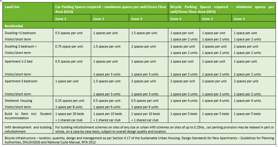
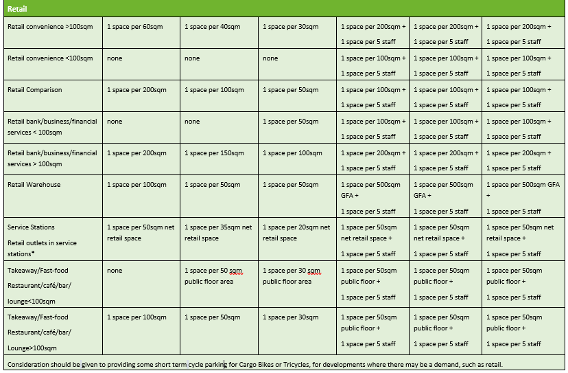
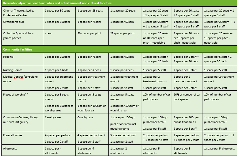
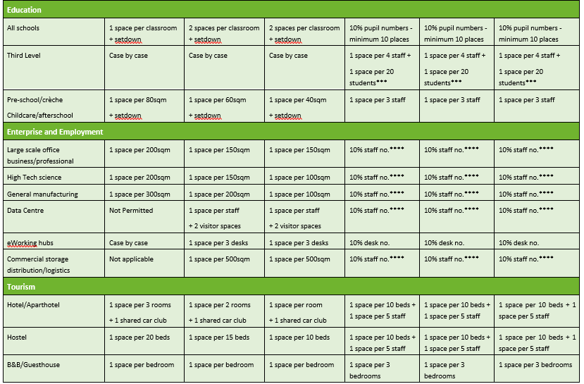
Table DM 8 (b): Car and Bicycle Parking Standards – Newcastle West and other settlement:
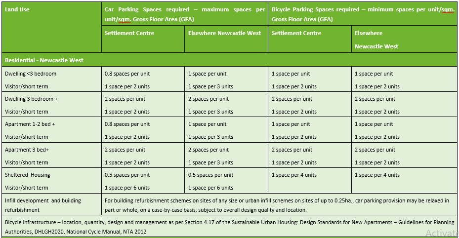
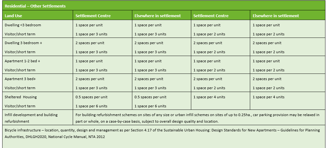
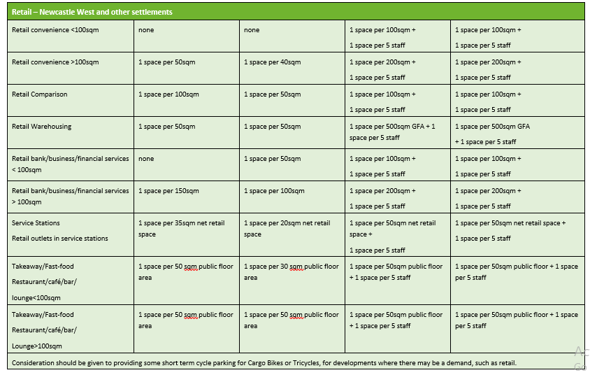
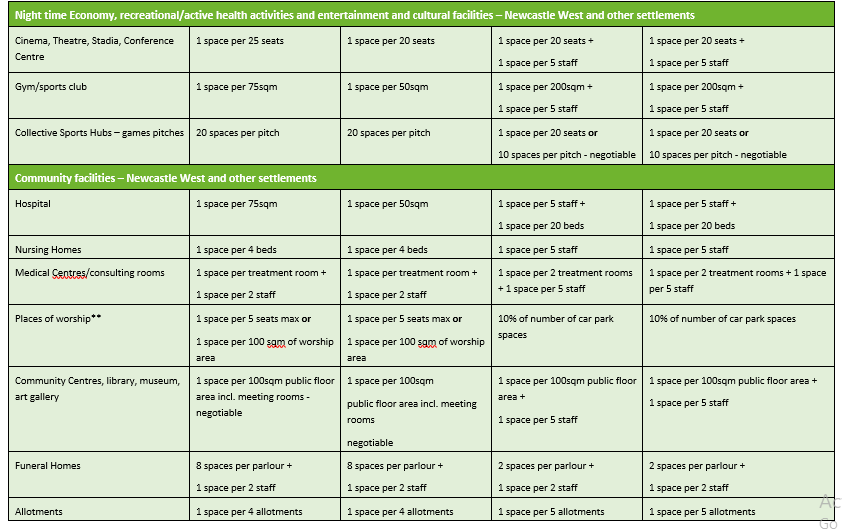
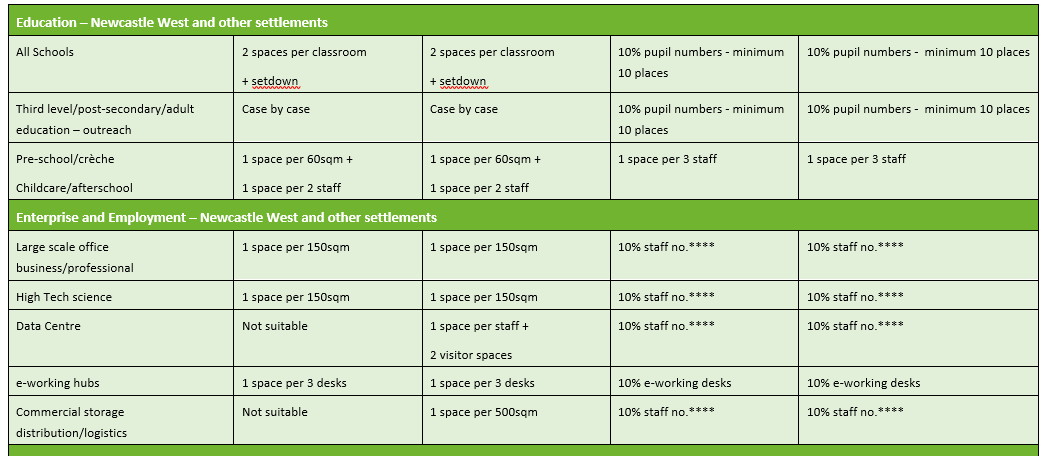

*1 HGV parking space required per 30sqm net floor area where food is served on premises in Zone 3. Rapid EV infrastructure to be provided for minimum of 2 car spaces where food is served on the premises.
**For places of worship without designated seating, parking required for auxiliary uses (e.g. day care) should be assessed separately. Floor area of the worship area refers to the floor area the denomination use for the observance of its religious services, including any balcony or area which can be opened on a temporary basis to such a sanctuary, hall or meeting room(s) by the removal or opening of any walls or partitions and any choir or musicians’ area, but excluding any areas intended solely for the use of the worship group leader such as altar or pulpit areas.
***Refers to fulltime staff and fulltime students.
*** Subject to a minimum of 10 spaces or one bike space for every car space, whichever is the greatest.
Parking requirements may be relaxed in exceptional circumstances. Applicants are advised to avail of pre-planning consultations with the Planning Authority prior to submitting planning applications. The developer will submit a Justification Assessment in the Mobility Management Plan providing the rationale for the deviation from the parking standards above and of national planning guidance for their proposed development. Exceptional circumstances may include:
- Limited/Restricted site area - Site size whereby refurbishment on sites of any size or urban infill schemes on sites of up to 0.25ha, car parking provision may be relaxed in part or whole, on a case-by-case basis, subject to overall design quality and location;
- Proximity to public transport service;
- Sustainable travel infrastructure supported by a Mobility Management Plan;
- Availability of car sharing and bike/e-bike sharing facilities on-site and in the vicinity;
- Existing car parking in the vicinity, including on street and the potential for dual use subject to agreement and management details;
- Impact on traffic safety and the capacity of the road network;
- Urban design, regeneration and civic benefits of the proposal including enhancement of public realm.
Where public car parking facilities have been provided or are to be provided which facilitate the development, in these cases, the Planning Authority will require the payment of a contribution towards the provision and management of such car-parking spaces. The amount of the contribution will be related to the size and the nature of the development.
Table DM 9: Car parking dimensions:
|
Standard Car Parking |
|
|
Parking dimensions – perpendicular to the kerb |
5m x 2.5m |
|
Where space is adjacent to a wall or other obstruction |
5m x 2.7m |
|
Parking dimensions – parallel to kerb |
6m x 2.5m |
|
Accessible parking bay to comply with building regulations |
5m x 2.5m +1.2m to the rear and sides of each space |
|
Angled parking - On wider roads or one-way streets, parking spaces can be angled according to the available road width. |
4.2m x 2.4m for 60° angle 3.6m x 2.4m for 45° angle |
|
Loading bay |
6m x 3m |
|
Circulation aisles |
6m width depending on alignment |
|
Mobility Impaired Parking |
|
|
Parking dimensions |
3m x 4.88m |
|
Loading bays |
6.1m x 3m |
|
Bicycle parking |
As per National Cycle Manual 2011 - The length of a standard bicycle is approximately 2.0m. A well-designed parking facility should provide 2.5m between the rows to allow cyclists room to manoeuvre when parking and collecting their bicycles. |
11.8.3.1 Motorcycle Parking
Motorcycles using standard car spaces is not an efficient use of land. The Planning Authority will seek a minimum of 1 secure motorcycle parking space for every 20 car parking spaces. The parking bays should be a minimum of 2.5m by 1.5 m. These spaces must be clearly indicated and must not compromise pedestrian or vehicle safety and movement.
11.8.4 Multi-Storey and Underground Car Parks
Multi-storey or underground basement car parks shall generally accord to the requirements set out in the UK’s Institution of Structural Engineers booklet entitled Design Recommendations for Multi Storey and Underground Car Park Fourth Edition’ (2011) and any subsequent updates. In assessing applications for multi-storey and underground car parks, the Planning Authority will have regard to the following:
- One way traffic routing is preferred for vehicular traffic;
- A splayed entrance with a 6.0 m. flat area at the exit point from a basement car park onto a main road with adequate pedestrian and vehicular sightlines;
- Sufficient headroom clearance (minimum 2.4 m.), should be provided to allow access for cyclists and high mobility vehicles for the mobility impaired;
- Adequate access/egress for cyclists;
- Adequate internal lighting and signage;
- Provision shall be made for an emergency access to underground car parks and, where more than 300 parking spaces are being provided, a second vehicular access point to an underground car park is required;
- Satisfactory proposals to address the disposal of surface water from the public road entering the car park and from the car park;
- Designs and layouts for underground car parks shall demonstrate that the development does not result in any potential for flooding from within or outside with particular emphasis on preventing egress of water through vents and access ramps;
- There should be no cumulative negative impact on the streetscape from overconcentration of car parks in a particular area.
11.8.5 Parking in Front Gardens
The cumulative effect of removal of front garden walls and railings damages the character and appearance of suburban streets and roads. Consequently, proposals for off street parking need to be balanced against loss of amenity. The removal of front garden walls and railings will not generally be permitted where they have a negative impact on the character of streetscapes (e.g. in Architectural Conservation Areas, Street Improvement Areas and other areas of architectural and historic character). Where the re-development of a drive-way is permitted the following shall apply:
- Not have outward opening gates;
- Have a vehicular entrance not wider than 3m;
- Have a vehicle entrance not wider than 50% of the width of the front boundary;
- Have an area of hardstanding (parking space of 2.5m x 5m). Suitably landscape the balance of the space taking into account the existing context;
- Dish and strengthen the footpath and relocate any services at the applicant’s expense;
- The hardstand/paving areas shall comprise a permeable (or porous) surface which allows water to drain through, such as gravel, permeable concrete block paving or porous asphalt, unless the rainwater is directed to a lawn or border to drain naturally.
11.8.6 EV Charging Points
All new car parks (other than residential development) will provide the necessary wiring/ducting capable of accommodating electric vehicle charging points at a rate of 10% of the total car park spaces and to the requirements of the ESB Networks and IEC 61851 Standard for Electric Vehicles Conductive Charging Points. This will also apply to applications seeking extensions to existing car parks. In new residential developments, each dwelling will be provided with charging point infrastructure and all parking spaces in an apartment/duplex complex will be provided with EV infrastructure by the developer.
11.8.7 End of Journey Cycling Facilities
All cycling facilities will be assessed in accordance with the NTA’s National Cycle Manual and any subsequent national guidance document. For cycle parking, refer to Section 11.8.5, DM Table 8a/8b above. Cycling facilities are considered critical to support the national transport principle of modal shift and is an important element of success of the Workplace Management Plans (Mobility Plans) and new higher density residential development, particularly apartment developments. For new residential developments of less than 5 units and non-residential developments of under 400 sqm, planning applications shall include a Cycle Statement, setting out how it meets the requirements of Council’s ‘Standards for Cycle Parking and Associated Cycling Facilities for New Developments’ (2018).
The Council encourages developers to provide on-site supporting infrastructure for the cyclist including safe, secure, weather protected parking and shower facilities in workplaces. The following should be adhered to:
- One shower for high tech/manufacturing and enterprise and employment development over 100sqm (over 5 employees);
- Two showers for high tech/manufacturing and enterprise and employment development over 500sqm (25 employees);
- One shower per 1000sqm thereafter;
- Changing facilities/drying areas, toilets and lockers to be provided with sufficient ventilation.
11.8.8 Taxi Services and Bus Shelters
Accessible taxi services are an important element of public transport. All planning applications for significant commercial, retail (including supermarket and neighbourhood development), high tech/manufacturing, enterprise and employment, health and other development will demonstrate the provision of adequate drop-off and pick-up areas for taxi services. Taxi ranks and bus shelters should be designed in accordance with best accessibility practice and in a manner that will not represent a traffic hazard, obstruct or distract, or create a conflict with pedestrians, cyclists, public transport or private vehicles.
Promotional or commercial advertising in bus shelters and other stand-alone structures that are an essential element of public infrastructure or provide a public amenity, such as telephone kiosks, will only be permitted in a format and location which is clearly integral and subsidiary to the structure as designed and does not detract from the surrounding location.
11.8.9 Road Reinstatement and Temporary Traffic Management during Construction Phases
Any damage to public roads or paths occurring as a result of a development shall be repaired to the satisfaction of the Local Authority and where deemed necessary, a cash security may be required to guarantee the satisfactory repair of damage. In certain circumstances, the road network may be deficient in carrying capacity and it may be appropriate to facilitate the development subject to a requirement that road strengthening works be undertaken by the Local Authority at the expense of the developer. In such circumstances, a development contribution shall be levied or in appropriate circumstances a condition may be imposed requiring works to be undertaken by the developer to Council specifications, including indemnification of the Council.
In terms of traffic management, the provisions of the Temporary Traffic Management Design Guidance, DTTS, 2019 and the Temporary Traffic Management Operations Guidance, DTTS, 2019 apply.
11.9 Tourism, Recreational Activities and Visitor Accommodation
11.9.1 Facilities/Amenities ancillary to Tourism and Recreational Attractions
Certain amenities and services are often required to support the enjoyment of tourism and recreational attractions. For example, such facilities include car parks, viewing points, toilets and cafes. The Council must be satisfied that facilities are justified through robust evidence, anticipating the need for and demand of the public for the attractions and inclusive access to basic restroom and refreshment facilities, to certain walks and open areas, taking into account local topographical constraints.
11.9.2 Sustainable Forms of Niche Tourism and Recreation
The Council will promote sustainable forms of niche tourism and recreation in the countryside. These include theme holidays and group based activities that take advantage of local and natural resources in a way that enhances the appreciation of place, minimises disturbance to the local environment and improves the prospects for tourism in the long term. As a general preference, facilities should be in existing settlements, or in buildings of character requiring renovation or in traditional farmhouses. Where new buildings are permitted outside of this framework, they should be modest in scale, sensitively located and designed having regard to existing buildings, topography and landscape, they should be adequately serviced and suitably managed.
11.9.3 Adventure Activities
Some recreational activities require resources that are generally only available in rural areas or sensitive natural heritage areas in the urban setting (eg water-based activities). The following standards and guidelines relate to these activities and to their appropriate setting. Such land uses and associated works shall be considered under the following criteria:
-
- All planning applications for these adventure/recreational activities involving special natural features, shall be accompanied by a management plan indicating projected numbers of users, hours of operation, seasons of operation and an undertaking to protect the natural environment in the form of a risk assessment with proposed amelioration measures in respect of flora, fauna, hydrology, geology and soils;
- All proposals should be accessible insofar as possible by sustainable means of transport including public transport and by modes other than the car;
- Where the traffic generated is likely to exceed the capacity of the local road network, or require changes to the road network that would adversely affect the character of the area, the use will not be permitted;
- Where the activity is likely to be noise generating, a noise assessment will be required in connection with the application, measuring likely noise levels at the nearest noise sensitive receptors. Noise sensitive uses include all residential uses, passive public amenities and the bloodstock industry. Where the use involves significant disturbance to any of these noise sensitive uses, that use will not be permitted in that location.
11.9.4 Visitor Accommodation and Holiday Homes
In particular, the Council promotes the redevelopment of brownfield sites, both in settlements and in rural areas, for the provision of tourist accommodation.
It is recognised that some forms of tourism developments, due to their scale or nature, may require a location outside of the settlement boundaries. Such developments include international-scale, integrated tourism developments e.g. golf courses. Such developments and their requirement to locate outside of an established settlement, will be assessed on a case-by-case basis having regard to their nature, scale, site suitability and normal planning considerations.
In general, Limerick City and County Council will not permit new single holiday homes in the countryside and will direct this type of development to settlements. Alternatively, this need can be met through the second hand housing stock in the countryside or the refurbishment of derelict dwellings/structures subject to the other planning matters, including water services and road safety. Similarly, brown-field sites in existing towns and villages may offer alternative opportunities for visitor accommodation.
11.9.5 Caravan/Camping/Glamping
The provision of tourist caravan parks to facilitate the expanding tourist industry is encouraged in appropriate locations by the Planning Authority. It is advised that the developer consult with the Environmental Health Officer, the Chief Fire Officer as well as the Planning Authority in advance of making a planning application. In assessing an application for a tourist caravan/camping/glamping park, the following matters will be assessed by the Planning Authority:
- Location of the development relative to existing services including retail, social facilities, access network and water services;
- Impact on existing residential amenities - overlooking, increased traffic and general disturbance will be taken into account;
- Capacity of the road network to cater for the development - direct access onto national primary or national secondary roads will not be permitted;
- Type and size of development - caravans for all year round occupation will not be permitted;
- Landscaping - every application for a caravan park will be accompanied by a comprehensive landscaping plan both proposed and existing;
- Compliance to Fáilte Ireland’s standards for caravan parks will be required;
- Sufficient waste management including recycling on the site;
- Provision of overnight EV charging points for users of the facilities.
Where connection to public wastewater network is not possible, the application must demonstrate that the proposed wastewater treatment system is suitably designed to cater for the development without negatively impacting on water quality in accordance with EPA Code of Practice. Consideration should be given to the selection of a wastewater treatment system that can adequately deal with periods of inactivity (i.e. when unoccupied for long periods such as outside the summer period). Where required, a caravan and camping development must hold a Section 4 Discharge Licence for the discharge of treated effluent to either surface or groundwater in accordance with the Local Government (Water Pollution) Acts 1977-1990.
11.9.6 Bed and Breakfast/Guest House/Hotel/Hostel/Apart-Hotel
In determining planning applications for new or change of use to bed and breakfast, guesthouse, hotel or hostel in residential areas, the Planning Authority will have regard to the following:
- Size, scale and nature of the business and the dwelling remaining the residence of the developer;
- Impact on existing residential amenity;
- Off-street parking provision;
- Signage; and
- Special designations such as Protected Structures, within the curtilage of Protected Structures, or located in Architectural Conservation Areas (ACAs).
11.10 Environmental Infrastructure
11.10.1 Hours of Construction
In the absence of a Construction Management Plan approved by the Planning Authority, hours of construction shall be as follows:
- Site development and building works shall be restricted to 7.00am to 7.00pm Monday to Friday and 8.00am to 2.00pm Saturdays. Deviations from these times will only be allowed in exceptional circumstances. No works shall take place on site on Sundays or Bank Holidays;
- There shall be no access onto the site before 7am or after 7pm in the absence of an approved deviation.
In certain instances, in order to address site specific issues of impact on residential or other sensitive amenity, a later start time and/or different hours may be conditioned.
11.10.2 Waste Management Infrastructure facilities and Refuse Transfer stations
Proposals for privately operated Waste Management Infrastructure facilities and refuse transfer stations will be required to have regard to the provisions of the appropriate European Council Directives, together with appropriate national legislation, regulations and guidance documents in respect of disposal of waste and disposal of toxic and dangerous waste in addition to normal planning criteria. Where permission is granted, the Planning Authority will impose strict conditions in the interest of health, safety and amenities. The provision of Waste Management Infrastructure facilities shall adhere to the Regional Waste Management Office’s Waste Management Infrastructure Siting Guidelines.
Waste Management Infrastructure facilities and refuse transfer stations will only be permitted where it does not materially detract from the relevant Land Use Zoning Objective and is at a scale appropriate to its surrounding environment and adjoining amenities.
The Council will consider the following when assessing development proposals for waste infrastructure:
- Compliance with the zoning objective for the subject lands;
- Justification for the proposal at the location, in particular having regard to the Southern Region Waste Management Plan 2015-2021, the Irish Water National Sludge Waste Management Plan 2016-2021 and any subsequent plans produced during the lifetime of this Draft Plan;
- The site is not in in a flood risk area;
- No adverse impacts on amenities, public health or road safety;
- Minimal risk of pollution and robust migration measures are demonstrated to the satisfaction of the Planning Authority and relevant environmental agencies and compliance with the requirements of the Water Framework Directive, the National River Basin Management Plan 2018-2021 and any subsequent plans during the lifetime of this Draft Plan;
- An appropriate buffer zone shall be provided around the site in order to protect the amenities of adjoining lands and properties. This buffer zone will be determined by the Planning Authority, in consultation with the EPA, where relevant; and
- Compliance with the requirements of the Habitats Directive.
11.11 Drainage and Water Supply
11.11.1 Development on the Foreshore
- Development along the coastline must consider coastal erosion and deposition and coastline movement. As a general principle, development in these area should be accommodated in previously developed areas before any consideration is given to the development on coastal greenfield sites;
- In all cases, proposals for coastal development shall consider coastal defence. Development will only be considered by the Council where it is satisfied that the development will not exacerbate erosion issues at the location, or elsewhere in the vicinity of the proposal or any defence works in the area;
- New development outside urban areas within 100m of the coastline at risk from coastal erosion is prohibited, unless it can be objectively established based on best scientific information available at the time of the application. The likelihood of erosion should be minimal accounting for any impacts in terms of erosion, deposition and predicted impacts of climate change. The Council prohibits development in areas liable to estuarine/coastal flooding in accordance with the 2009 guidance – The Planning System and Flood Risk Management - Guidelines for Planning Authorities, DEHLG and OPW;
- Some developments require foreshore licences under the Foreshore Act 1933. The Department for Housing, Planning and Local Government issues this consent. The foreshore is classed as the land and sea bed between the high water of ordinary tides and the 12 nautical mile limit. Foreshore also covers the tidal areas of rivers, particularly estuaries. For development on state-owned or private foreshore adjacent to the Local Authority functional area, planning permission is required from the Council or from An Bord Pleanála if the proposal is deemed a Strategic Infrastructure Development (SID) in accordance with the Planning and Development (Strategic Infrastructure) Act 2006, also.
* Any person proposing to undertake works or an activity on the foreshore should contact the Marine Planning and Foreshore Section of the Department of Housing, Planning and Local Government in advance, to ascertain if foreshore consent is required. Refer to housing.gov.ie/consent-project-types.
11.12 Environment and Heritage
Refer to Chapter 5: Environment, Heritage, Landscape and Green Infrastructure and Volume 3 for Architectural Conservation.
Contents
Materials
Observations
Observations
Inclusion of green roofs provision so that they may be used as part of planning requirements
Submission on behalf of South West Regional Shopping Centre Promotions Association
Please see attached