Chapter 2: Core Strategy
Chapter 2: Core Strategy
2.1 Introduction
This chapter sets out the Core Strategy, which informs the overall framework for the objectives and policies throughout the Draft Plan. The Core Strategy provides a transparent evidence-based rationale for the amount of land proposed to be zoned for new residential development and for mixed use development, involving a residential component that is required to meet the proposed population growth over the lifetime of the Draft Plan period, at settlement level. The central focus of the Core Strategy is to ensure there is an acceptable equilibrium between the supply of zoned and serviced land for the projected demand for new housing, jobs, social and economic infrastructure. The Core Strategy also aims to translate the overall vision and goals set out in Chapter 1: Introduction, Vision and Strategic Vision into a spatial development strategy for Limerick.
This chapter is prepared in the context of Section 10 of the Planning and Development Act 2000 (as amended), the National Planning Framework (NPF), the Implementation Roadmap for the NPF, the Regional and Spatial Economic Strategy for the Southern Region (RSES) and Section 28 Ministerial Guidelines.
In line with the provisions of the Act, the Core Strategy includes a Written Statement, a Core Strategy Map, which identifies the main settlements, existing road and rail routes, designated rural areas in the county and also a Core Strategy Table. Information on the economic strategy, including the Draft Retail Strategy for the Limerick Shannon Metropolitan Area and County Limerick is also included within this chapter.
2.2 National and Regional Policy Context
At a national level, the NPF sets out parameters for growth for the regions, cities, towns and rural areas. These parameters are further developed in the Southern Regional Spatial and Economic Strategy. The Core Strategy acts as the fundamental link between national, regional and local planning levels by demonstrating that the local planning policy is consistent with higher-level national and regional policy.
The NPF recognises the Limerick City region as a key asset, that will play a major role in both driving and accommodating a significant proportion of the proposed national population growth and will act as an effective complement to the economic strength of Dublin. Ensuring a balanced approach in activating and realising much underutilised potential in the wider rural towns and dispersed communities is also a priority.
The NPF proposes that within Limerick, future growth will be based on leveraging national, regional and international connectivity, higher education capacity and quality of life to secure strategic investment. This must be underpinned by sustainable employment and housing development, focused on the broader Limerick Shannon Metropolitan Area and a strengthening of the urban cores of the county towns and principal settlements, as well as in rural areas.
The RSES for the Southern Region sets out a number of strategic outcomes that align to the NPF, including the sustainable growth of a compact city, towns and villages to achieve better residential development across the Southern Region. The RSES contains a Metropolitan Area Strategic Plan (MASP) for the Limerick Shannon area. The MASP for Limerick-Shannon emphasizes that a dynamic approach to land-use within the footprint of existing settlements is sought by the RSES in order to maximise the opportunity of urban regeneration and infill sites to contribute to sustainable balanced and compact growth and revitalisation of our existing settlements of scale. The vision statement for the Limerick Shannon Metropolitan Area is:
‘To create a sustainable, inclusive, smart, climate and economic resilient Limerick Shannon Metropolitan Area, which is competitive and of a scale which can exert critical-mass leverage at an international level, maximising the economic, social, cultural and environmental opportunities in a manner for all those who live, work and visit the Metropolitan Area, Mid-West Region and for the benefit of the country’.
2.3 Core Strategy Methodology
The Core Strategy is developed around a framework of high-level population and household targets that are set out in the NPF, the NPF Implementation Roadmap, the RSES for the Southern Region and Section 28 guidance document ‘Housing Supply Target Methodology for Development Planning’, (DHLGH, December 2020).
There are a number of steps involved in preparing the Core Strategy:
- Identify population projections for 2016 to 2028;
- Identify household projections for 2022 to 2028;
- Identify the proposed settlement hierarchy;
- Allocate population/households to settlements;
- Identify quantum of zoned land required to accommodate proposed growth.
2.3.1 Population Projections
The population projections for Limerick are set out in the NPF Implementation Roadmap (see Table 2.1) and the Southern Region RSES.
Table 2.1: NPF Implementation Roadmap Population projections for Limerick
|
Year
|
2016 |
2026 |
2031 |
|
Population projections |
195,000 |
229,000-235,500 |
246,000-256,500
|
Assuming even population growth, these population projections translate to an additional population of circa 49,200 for the Draft Plan period.
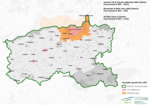
The Southern Region RSES also provides for population targets for the Limerick Shannon Metropolitan Area Strategic Plan (MASP) area specifying the allocations for the City and those parts of the MASP area outside of the City that lie within Limerick (see Figure 2.1).
The NPF 2016-2031 population growth allocation for the MASP area is 39,948. On a pro-rata basis, the population growth should be 31,918 by the middle of 2028. In order to comply with NPO 9 of the NFP, which recommends that settlements other than the Cities and key towns should grow by a maximum of 30% over the lifetime of the Draft Plan, it is necessary to increase the proportion of population allocation to the MASP area to 36,394, equivalent to a further 14% over the 31,918 pro-rata allocation. The growth allocations for the remainder of the county are thereby reduced accordingly, so that the growth on aggregate of all settlements outside of the Metropolitan Area will be c.26% over their 2016 population base. Section 2.3.4 further expands on the proposed population and household distribution.
Figure 2.1: Population growth allocations for MASP area and remainder of Limerick
In preparing the Core Strategy, the patterns of development up to 2022 were also taken into account. A review of commencements of planning permissions along with Geodirectory information, was used to undertake this exercise. The following Table 2.2 shows the forecast for additional population growth during the Draft Plan period and the estimated growth between 2016 and May 2022, the time at which the Draft Plan is due to be adopted.
Table 2.2: Population growth Q3 2016-Q2 2028, with estimate of growth up to Q2 2022 and future growth to be facilitated by end of 2022-2028 Development Plan period
|
Settlement category |
2016-2028 population growth |
Population growth estimate post 2016 census up to Q2 2022 |
Population growth during Plan period Q2 2022-Q2 2028 |
|
City and environs, including Mungret and Annacotty |
34,177 |
4,071 |
30,106 |
|
Remainder of Limerick |
15,045 |
3,490 |
11,555 |
|
Total city and county |
49,222 |
7,561 |
41,661 |
2.3.2 Household Projections for 2022 to 2028
Under Section 28 of the Planning and Development Act, 2000 (as amended), the ‘Housing Supply Target Methodology for Development Planning, Guidelines for Planning Authorities’ were issued on 18th December 2020. These Guidelines provide the methodology to be adopted by Local Authorities in formulating the housing supply target for their statutory Development Plan. The methodology utilises research undertaken by the Economic and Social Research Institute – ‘Regional Demographics and Structural Housing Demand at a County Level’, Research Series, Number 111, Economic and Social Research Institute (ESRI), December 2020. The guidelines are to be applied by each Planning Authority to assist in ensuring that their Development Plan is prepared to be consistent with the National Planning Framework and relevant Regional Spatial and Economic Strategy.
To support each Planning Authority in applying the methodology, comprehensive background data necessary for the methodology calculation in Table 1 of the Guidelines, were issued to each Planning Authority in January 2021. Using this methodology, the projected households for Limerick from the year 2022 to 2028 are set out in Table 2.3.
Table 2.3: Household Projections for Limerick 2022-2028
|
Row indices |
Steps as per S28 guidance |
Households |
|
A |
ESRI NPF scenario household demand 2017- Q2 2026 |
21,014 |
|
B |
Actual new housing supply 2017 to Q2 2022 |
2,840 |
|
C |
Homeless households (latest data) and unmet demand as at most recent census |
461 |
|
D |
Plan Housing Demand = Total (A-B)+C Projected ESRI NPF demand – new completions) + unmet demand |
18,635 |
|
E |
Potential adjustment 1 to end 2026 portion of Plan period to facilitate convergence to NPF strategy |
Adjusted total demand |
|
E1 |
ESRI Baseline scenario projected new household demand 2017 to Q4, 2026 |
12,232 |
|
E2 |
ESRI NPF scenario projected new household demand to Q2 2028 |
2,693 |
|
E3 |
Mid-point between A and E2 (ESRI NPF and baseline scenarios, to Q4 2026 |
15,277 |
|
E4 |
Household forecast 2022-2028 Plan period |
15,591 |
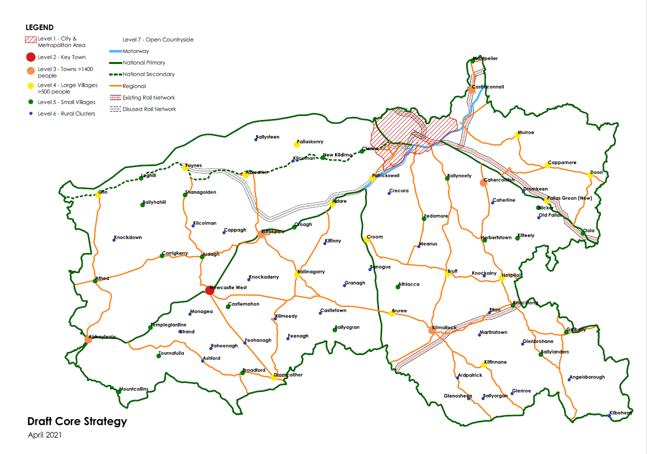
2.3.3 Settlement Hierarchy
A settlement hierarchy is a way of arranging settlements into a hierarchy based upon their population or some other criteria, such as the range of services. As you move up the settlement hierarchy, the size of the settlement increases, as does the population and the range of services available.
The following considerations were taken into account in preparing the settlement hierarchy for Limerick, which is set out in Table 2.4 below:
- Limerick City Metropolitan Area, including Mungret and Annacotty is designated for significant growth under the NPF and RSES;
- Towns that are located within the Limerick Shannon MASP;
- The designation of Newcastle West as a Key town in the RSES;
- The availability of planned physical and social infrastructure (education, community facilities, retail etc.);
- Scale of existing population and its performance;
- Historic role and function of the settlement;
- Towns that have strong employment and service centres;
- Extent to which sustainable modes of travel can be encouraged (walking, cycling or public transport);
- Environmental considerations.
Table 2.4 Limerick Settlement Hierarchy
|
|
2.3.4 Population/Household Distribution
In line with the NPF and RSES, a significant portion of Limerick’s proposed growth will be in the Limerick City Metropolitan Area. In towns and smaller settlements outside of this area, the overall objective is to ensure that these settlements grow at an appropriate rate where both physical and social infrastructure keeps pace with population growth.
Having regard to the population and household projections and the settlement hierarchy identified in Section 2.3.3 above, the population and household projections to 2028 are allocated to each settlement hierarchy as set out in Table 2.5.
Table 2.5 Projected population and household growth per settlement hierarchy
|
Settlement Hierarchy |
2016 population (CSO census) |
Settlement population totals 2028 |
Additional households forecasted 2022-2028 |
|
Level 1 Limerick City including Annacotty and Mungret |
92,878 |
127,055 |
11,274 |
|
Level 2 Key Towns |
8,287 |
10,742 |
868 |
|
Level 3 Towns |
7,047 |
8,946 |
688 |
|
Level 4 Large Villages (>500 population) |
12,964 |
17,135 |
1,454 |
|
Level 5 Small Villages |
5,913 |
7,214 |
340 |
|
Level 6 Rural clusters |
1,613 |
1,855 |
91 |
|
Level 7 Open Countryside |
66,197 |
71,174 |
876 |
|
Total Limerick |
194,899 |
244,121 |
15,591 |
The following approach was adopted in deciding the appropriate growth rates for the different settlements within the settlement hierarchy:
- Within the Metropolitan Area, the bulk of this population allocation is to be facilitated within the City and two settlements that are attached to the city, namely Mungret and Annacotty and for which there already is extensive zoned lands available. Outside of the City and Environs Area, Patrickswell and Castleconnell are considered settlements that are suitable for growth due to their location within the MASP area and also the availability of existing infrastructure.
- The allocation of growth targets in general, seeks to ensure that the growth would be sustainable and in keeping with the scale of the settlements. It also ensures the capacity to accommodate the additional growth without damage to the settlement’s character and the carrying capacity of their environment and infrastructure. In accordance with the NPF the population growth rates are generally not proposed in excess of 30% of the 2016 population, within the Draft Plan period. However, there are certain limited exceptions as noted below.
- In general, uniform growth rates are applied to settlements according to the Level in the hierarchy to which they belong, with 30% growth over the 2016 population base allocated to the key town of Newcastle West. 28% growth is allocated to settlements in Levels 3 and 4 in the hierarchy and 23% to settlements in Level 5. The lowest Level in the hierarchy is that of the open countryside where, in keeping with long term trends, the growth rate is to remain relatively low at 7.52% from 2016 to 2028.
- The extent of residential development, which has occurred since the 2016 Census will affect the growth of future housing within the Draft Plan period. In respect of settlements which saw uniform growth rates over the 2016 population, the requirement for additional housing during the Draft Plan period, when growth since 2016 is taken into account, will result in some settlements having a greater need for additional housing than others of similar size.
- In certain circumstances, either where residential development has been constructed after the 2016 census, or where there is outstanding planning permission for dwelling units, such developments or commitments may result in these settlements already breaching or close to breaching the 30% rate. In these cases it is considered important that an allowance for growth on sites without the benefit of planning permission, taking into account spare capacity and the criteria outlined in Section 2.3.3 above is made. This results in growth rates in excess of the 30% rate referred to above in the village of Patrickswell. This is a Metropolitan settlement where there are outstanding planning permissions for 270 dwelling units and therefore a growth rate of 97% is proposed to reflect the extant permissions.
2.3.5 Determining the Quantum of Zoned Land Required to Accommodate Proposed Growth
A number of factors were considered in determining the quantity of zoned land required for each settlement on the hierarchy. This included the number of proposed housing units, density, tiered approach to zoning, potential of mixed use zoned land to accommodate housing units and national and regional objectives to significantly grow Limerick City and Environs.
2.3.5.1 Proposed Housing Allocation
The proposed housing targets, which are outlined in the sections above, were distributed based on the settlement hierarchy.
2.3.5.2 Density
It is a requirement of Section 10(2A)(a) of the Act that the Core Strategy is consistent with planning policy requirements of guidelines issued under Section 28 of the Act. The Guidance Note on Core Strategies clearly reinforces that density assumptions used in the preparation of a Core Strategy should be consistent with the Planning Guidelines for Sustainable Residential Development in Urban Areas (2009).
The average housing densities, that determine the residential yield from sites depends on the location of that site, which settlement it belongs to, where that settlement fits within the settlement hierarchy, the site’s position with respect to the urban core, the proximity to public transport corridors and to major employment zones. Where communities live in areas of medium to high residential densities, the prospects improve for local services and amenities, use of sustainable transport modes for daily journeys and the reduction of unsustainable travel patterns.
Within settlements outside of the City and Environs, allowance will be made for the development of serviced/cluster sites, which will act as an alternative to one off rural housing. In line with the Planning Guidelines for Sustainable Residential Development in Urban Areas up to 20% of proposed housing units within these settlements will be allocated to serviced sites at a density of 10 units per hectare. This is reflected in Table 2.6 below.
In line with the above considerations and Section 28 Guidelines, the following density assumptions were applied to the settlement hierarchy:
Table 2.6: Density Assumptions per Settlement Hierarchy
|
Settlement Hierarchy |
Density applied |
|
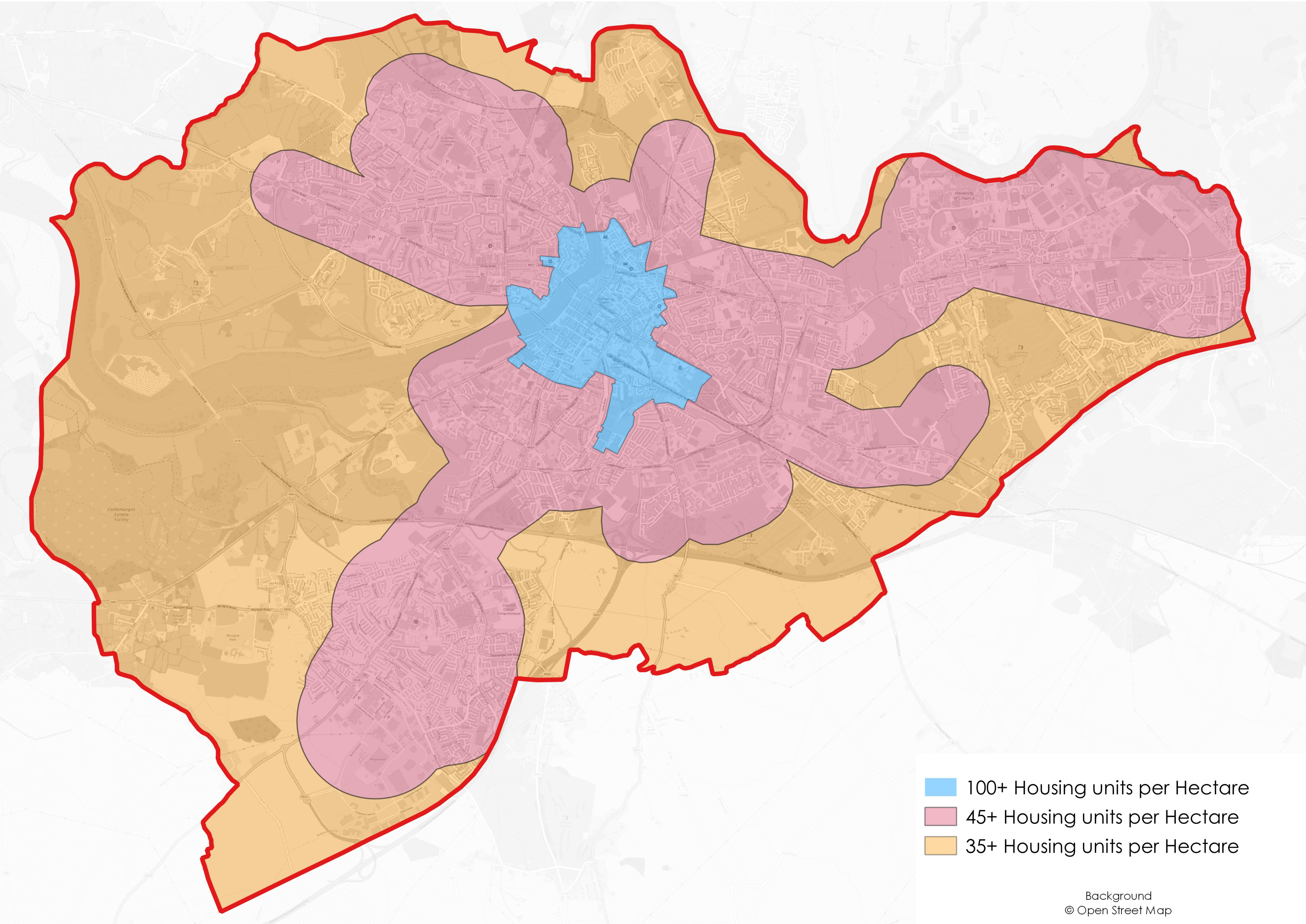
Level 1 Limerick City (see Figure 2.2 below) |
Density Zone 1: City Centre, Central & Accessible Locations: A minimum net density of 100+ dwelling units per hectare are required at appropriate locations within the City Centre. Density Zone 2: Intermediate Urban Locations/Transport Corridors: A minimum net density of 45+ dwelling units per hectare are required at appropriate locations within: 800 metres of (i) the University Hospital; (ii) Raheen Business Park; (iii) National Technology Park; (iv) University of Limerick; (v) Limerick Institute of Technology; (vi) Mary Immaculate College; 500m of high frequency (min. 10 minute peak hour frequency) existing or proposed urban bus services and; 400m of reasonably frequent (min. 15 minute peak hour frequency) urban bus services. Density Zone 3: Suburban Edge: A minimum net density of 35+ dwelling units per hectare are required at sites in suburban development areas that do not meet proximity or accessibility criteria of the Intermediate Urban Locations. |
|
Level 2 Key Towns |
35 uph for 80% of dwelling units and 10 uph for 20% of dwelling units proposed |
|
Level 3 Towns |
22 uph for 80% of dwelling units and 10 uph for 20% of dwelling units proposed |
|
Level 4 Large Villages (>500 population) |
22 uph for 80% of dwelling units and 10 uph for 20% of dwelling units proposed |
|
Level 5 Small Villages |
See objective SS 014 in Chapter 3 |
|
Level 6 Rural Clusters |
See objective SS 015 in Chapter 3 |
|
Level 7 Open Countryside |
N/A |
Figure 2.2 Limerick City and Environs Density Zones
2.3.5.3 Tiered Approach to Zoning
In accordance with the methodology set out in Appendix 3 of the NPF, a tiered approach to zoning was applied through the carrying out of an infrastructural assessment for each of the zoned settlements within the Draft Plan. See Volume 2 of the Draft Plan for further details.
2.3.5.4 Potential Housing Yield on Town Centre/Mixed Use Zoned Land
The potential housing yield on Town Centre/mixed use (in the case of Limerick City and Environs) zoned land was considered on a case by case basis, having regard to the vacancy and dereliction within each settlement and also the quantum of land zoned for Town Centre/mixed use development within the particular settlement. Consideration of this issue can be found within Volume 2 of the Draft Plan, which contains a description, infrastructure assessment report and zoning maps for the Limerick City Metropolitan Area and a number of Level 4 settlements. Local Area Plans will be prepared for the remaining Level 4 settlements, at which stage consideration will be given to the potential housing yield on Town Centre zoned land for that particular settlement.
2.4 Core Strategy Statement
The approach in developing the Core Strategy is focused on developing and strengthening the role of Limerick City as an international City of scale, the key towns of Newcastle West and Kilmallock, large towns, villages and rural clusters. There is a focus on increasing residential densities and employment in the City and main towns, thereby decreasing the distance that people have to travel from their home to work. The strategy is also focused around settlements with good public transport links and improving public transport links in other settlements, highlighting the importance of integrating land use and transportation to help reduce greenhouse gas emissions and facilitate the transition to a low carbon economy.
Guidance throughout the Draft Plan on housing densities, building height and development layouts, are all aimed at ensuring the economic use of land for development, compact, quality neighbourhoods and integration with infrastructure and non-residential land uses that nurtures sustainable travel patterns and choices.
Prioritising the development of brownfield sites and reducing vacancy in Limerick City and Town Centres should also assist in the increase in average densities and in helping to revitalise many rural towns and villages as well as their surrounding areas. Chapter 10: Compact Growth and Revitalisation outlines objectives for the regeneration of opportunity sites within the City with a view to realising their full potential to contribute to the growth of the city. For larger settlements, Local Area Plans will be prepared, during which time opportunities will be identified for brownfield and regeneration opportunities. Furthermore, Volume 2 sets out development objectives for a number of Level 4 settlements where this issue has been considered.
The Settlement Hierarchy is developed around seven Levels. While each Level serves a different strategic role, together they will achieve a balanced, spatial planning settlement framework, which supports our urban and rural areas. All settlements, regardless of their Level, have an important role and contribution to make to the economic and social life of Limerick. A summary of the overall role of the settlements is outlined below, while the settlement strategy in Chapter 3: Settlement and Housing Strategy, provides specific circumstances in relation to each Level within the settlement hierarchy.
The Draft Plan aims to facilitate the sustainable growth of Limerick City and Environs in line with the NPF and RSES, which supports ambitious growth targets to enable Limerick City and Environs to grow by at least 50% by 2040 and to achieve its potential to become a City of scale. This area forms part of the Limerick Shannon Metropolitan Area in the RSES, coming within the scope of the Limerick Shannon Metropolitan Area Strategic Plan (MASP) and as such is a priority growth area within the strategy’s policy framework. The MASP recognises that for the Metropolitan Area to prosper and develop in a sustainable manner, Limerick City must be the primary driver of economic and population growth in the Southern Region, so that it can compete effectively for investment and jobs.
There are a number of districts within the Limerick City Metropolitan Area, which provide important opportunities for the sustainable development of residential, educational, recreation and amenity, employment and commercial uses. These include the Ennis Road, Caherdavin, Thomondgate, Corbally, Rhebogue, Garryowen, South Circular Road /Ballinacurra, Castletroy, Raheen/Dooradoyle and Mungret. The National Planning Framework also recognises the importance of sustainable development of new greenfield areas and specifically refers to Mungret as a key future growth enabler for Limerick in terms of ‘progressing the sustainable development of new greenfield areas for housing and the development of supporting public transport and infrastructure’. To do this, growth must complement and consolidate the urban form of the City as a whole to create a compact City region with improved integrated supporting infrastructure, public transport improvements to provide linkages to local residential populations and the provision of high levels of community facilities and amenities. The integration of the designated Regeneration Areas, including Moyross, Southill, Ballinacurra Weston and St. Mary’s Park into the wider City area is also an important focus of the Draft Plan.
Outside of the city, the policy intention is to focus on supporting sustainable and vibrant rural communities by supporting and regenerating towns and villages. This will be facilitated through a number of measures including active land management measures, effective use of funding streams for town/village and public realm improvement (including the Rural Regeneration Development Fund (RRDF), LEADER etc.), working with community groups and utilising available statutory powers such as derelict site and compulsory purchase powers. The promotion of an alternative to one off rural housing in the open countryside, through initiatives like serviced sites and redevelopment of vacant units in town, villages and rural areas, will be encouraged. This will support the regeneration of these settlements.
Within the open countryside, the Draft Plan identifies two types of areas for rural housing:
- Areas under urban influence and
- Rural areas elsewhere and recommends a policy approach to each area, which supports those who have a need to live within the rural area.
2.5 Local Area Plans
The Core Strategy provides an objective evidence base to allow for an area to be zoned for development, which can then be delivered in a sustainable and planned manner through the vehicle of an adopted statutory Local Area Plan (LAP). At a local level, statutory LAPs are the primary vehicles for guiding and informing the content, layout and design of both ‘new’ and ‘redevelopment’ areas in various settlements. Any new and/or amended LAP will be prepared having regard to all relevant planning guidelines and policies and guidance of the Draft Plan. Localised design based frameworks shall be provided for each plan area, including detailed and specific design parameters and urban design contexts, as appropriate, for the specific areas.
The Draft Plan incorporates the areas currently covered by the Southern Environs Local Area Plan and the Castletroy Local Area Plan. This will ensure that for the first time, the City and Environs will have one overall spatial framework and zoning objectives. Following the adaption of the Draft Plan, both the Castletroy and the Southern Environs Local Area Plans will be revoked.
The Draft Plan also incorporates zoning objectives and policies for a number of settlements that are currently covered by existing Local Area Plans, including Bruff, Hospital, Cappamore and Kilfinane. The following existing LAPs will be reviewed and new Plans prepared following the adoption of the Draft Plan: Newcastle West, Abbeyfeale, Adare, Askeaton, Caherconlish, Castleconnell, Croom, Kilmallock, Patrickswell and Rathkeale.
2.6 Employment Development
2.6.1 Employment Strategy
To complement the preparation of the Core Strategy, the Guidance Note on Core Strategies (2010) states that Planning Authorities should undertake an appropriate level of analysis to ensure that sufficient lands are identified for employment purposes at suitable locations, taking proper account of national planning policies. While the Guidance document does not provide a methodology for determining the appropriate quantum of employment zoned lands, the Draft Plan sets out objectives and zoning of land for employment uses that has regard to national policy, the Draft Limerick Shannon Metropolitan Area Transport Strategy (LSMATS) and the availability of infrastructure.
The employment strategy aims to develop Limerick’s enormous competitive advantages, including its central location on the Atlantic Economic Corridor, its national and international trade and tourism connectivity through Shannon Airport and Shannon Foynes Port Company and its third level complement, via the University of Limerick, Limerick Institute of Technology and Mary Immaculate College, that ensures constant supply of graduates. The NPF and NDP’s support for the implementation of the Limerick 2030 Plan will also help realise the potential to generate and be the focus of significant employment growth. It is ideally positioned from a scale and capacity perspective, to accommodate significant population and economic growth as proposed in the NPF.
Chapter 4: A Strong Economy sets out the policies and objectives for economic development over the Draft Plan period. The overall objective of the Draft Plan is to ensure that there is sufficient zoned land, based on the principles of sequential development, to accommodate the overall growth proposed and also to recognise the importance of Limerick City Metropolitan Area as a regional employment centre.
2.6.2 Retail Strategy
Section 10(2A)(e) of the Act requires a Core Strategy to contain information to show that, in setting out objectives regarding retail development, the Planning Authority has had regard to Section 28 Guidelines that relate to retail planning. A successful retail sector that safeguards existing retail floor space, as well as providing additional floor space has an important role to play in realising the aims of the Settlement Strategy.
In line with the RSES MASP Objective 17, a Draft Retail Strategy for the Limerick Shannon Metropolitan Area and County Limerick was prepared. This document, which also considered the remainder of Limerick outside of the MASP area, is included in Volume 6.
The Strategy is aligned to the Core Strategy and the Settlement Hierarchy. It focuses on maintaining and further developing Limerick City for its dominant retail function in the Mid-West hierarchy, the development of District Centres, the Key Towns of Newcastle West and Kilmallock and other towns as the main retail centres in the county. The development of retail services in the smaller settlements will be focused on providing support services for their respective populations and rural hinterlands.
The Draft Plan recognises that the retail sector is pivotal to regeneration and renewal of Town Centre areas, their economic viability and delivery of a high-quality public realm, built environment and sense of place.
2.7 Core Strategy Map
(Refer to Chapter 3: Settlement and Housing Strategy for Rural Settlement Strategy Map)
2.8 Core Strategy Policies
Policy CSP P1: Core Strategy Implementation - It is a policy of the Council to implement the Core Strategy for Limerick to ensure consistency with policies at a national and regional level, in particular population targets and distribution.
Policy CSP P2: Compact Growth - It is a policy of the Council to support the compact growth of Limerick City Metropolitan Area, towns and villages by prioritising housing and employment development in locations within and contiguous to existing City and town footprints where it can be served by public transport and walking and cycling networks, to ensure that development proceeds sustainably and at an appropriate scale, density and sequence, in line with the Core Strategy Table.
Policy CSP P3: Availability of Land - It is a policy of the Council to ensure that sufficient zoned land continues to be available for the projected population and employment growth over the lifetime of the Draft Plan.
Policy CSP P4: Local Area Plans - It is a policy of the Council to use Local Area Plans, that form part of the hierarchy of plans within Limerick, to promote and embed the principles of good urban design in the delivery of new and existing, sustainable communities. Following the adoption of the Draft Plan, a review of the existing Local Area Plans will be undertaken to ensure consistency with the Core Strategy and policies and objectives of the Development Plan.
2.9 Core Strategy Tables
The Core Strategy Tables indicate the distribution of future population and housing growth across Limerick’s settlements in the form of a settlement hierarchy; they also set out the zoned lands available in selected settlements for new housing where relevant.
Table 2.7 (one of two) Settlement hierarchy, population and household growth up to end of Draft Plan period Q2 2028 plus zoned land provision
|
|
Settlements and settlement tiers |
2016 population (CSO census) |
2016-2028 population growth |
Settlement population totals 2028 |
Settlement population growth 2016-2028 as % of 2016 base |
Additional households forecasted 2022-2028 |
Quantum of zoned land required to accommodate additional growth in ha. |
Existing zoned land undeveloped and available in ha. [1] |
Excess or deficit in zoned land |
|
Level 1 |
Limerick Metropolitan City and Environs including Mungret and Annacotty |
92,878 |
34,177 |
127,055 |
36.80% |
11,274 |
358 |
Capacity for 12,322 units on zoned lands |
|
|
Level 2 |
Newcastle West |
6,619 |
1,988 |
8,607 |
30.04% |
706 |
30.27 |
144.10 |
113.83 |
|
Kilmallock |
1,668 |
467 |
2,135 |
28.00% |
162 |
9.14 |
33.83 |
24.69 |
|
|
|
Level 2 settlements on aggregate |
8,287 |
2,445 |
10,742 |
29.02% |
868 |
39.41 |
177.93 |
+138.52 |
|
Level 3 - Towns |
Castleconnell |
2,107 |
590 |
2,697 |
28.00% |
206 |
11.59 |
24.89 |
13.30 |
|
Abbeyfeale |
2,023 |
566 |
2,589 |
28.00% |
211 |
11.89 |
45.50 |
33.63 |
|
|
Rathkeale |
1,441 |
403 |
1,844 |
28.00% |
147 |
8.30 |
41.42 |
33.14 |
|
|
Caherconlish |
1,476 |
339 |
1,815 |
23.00% |
125 |
7.02 |
9.94 |
2.93 |
|
|
Level 3 settlements on aggregate |
7,047 |
1,899 |
8,946 |
26.75% |
688 |
38.8 |
121.75 |
82.95 |
|
|
Level 4 -Settlements[2] |
Adare |
1,129 |
326 |
1,455 |
28.89% |
98 |
5.51 |
62.71 |
+57.2 |
|
Askeaton |
1,137 |
318 |
1,455 |
28.00% |
119 |
6.72 |
23.54 |
+16.83 |
|
|
Ballingarry |
521 |
146 |
667 |
28.00% |
55 |
3.08 |
2.81 |
-0.27 |
|
|
Bruff |
803 |
240 |
1,043 |
29.87% |
83 |
4.68 |
5.32 |
+0.64 |
|
|
Bruree |
580 |
160 |
740 |
27.55% |
39 |
2.21 |
1.73 |
-0.49 |
|
|
Cappamore |
620 |
174 |
794 |
28.00% |
65 |
3.66 |
3.32 |
-0.34 |
|
|
Croom |
1,159 |
325 |
1,484 |
28.00% |
104 |
5.84 |
28.76 |
+22.92 |
|
|
Doon |
516 |
144 |
660 |
28.00% |
52 |
2.91 |
2.70 |
-0.21 |
|
|
Dromcolliher |
518 |
145 |
663 |
28.00% |
54 |
3.06 |
2.49 |
-0.57 |
|
|
Foynes |
520 |
146 |
666 |
28.00% |
55 |
3.07 |
2.49 |
-0.58 |
Table 2.5 (two of two) Settlement hierarchy, population and household growth up to end of Draft Plan period Q2 2028 plus zoned land provision
|
|
Settlements and settlement tiers |
2016 population (CSO census) |
2016-2028 population growth |
Settlement population totals 2028 |
Settlement population growth 2016-2028 as % of 2016 base |
Additional households forecasted 2022-2028 |
Quantum of zoned land required to accommodate additional growth ha. |
Existing zoned land undeveloped and available ha. |
Excess or deficit in zoned land |
|
|
Glin |
576 |
161 |
737 |
28.00% |
59 |
3.33 |
3.10 |
-0.23 |
|
|
Hospital |
653 |
183 |
836 |
28.00% |
64 |
3.58 |
3.32 |
-0.26 |
|
Kilfinane |
789 |
221 |
1,010 |
28.00% |
81 |
4.59 |
3.79 |
-0.80 |
|
|
Murroe |
1,377 |
317 |
1,694 |
23.00% |
117 |
6.61 |
5.82 |
-0.79 |
|
|
Pallasgrean |
568 |
159 |
727 |
28.00% |
60 |
3.36 |
3.11 |
-0.25 |
|
|
Pallaskenry |
651 |
185 |
836 |
28.46% |
63 |
3.53 |
3.60 |
+0.07 |
|
|
Patrickswell |
847 |
822 |
1,669 |
97.03% |
287 |
16.20 |
34.64 |
+18.44 |
|
|
Level 4 settlements on aggregate |
12,964 |
4,171 |
17,135 |
32.18% |
1,454 |
81.96 |
193.25 |
111.29 |
|
|
Level 5 |
Level 5 settlements on aggregate
|
5,913 |
1,301 |
7,214 |
22.01% |
340 |
|
|
|
|
Level 6 |
Non-census settlements |
1,613 |
242 |
1,855 |
15.00% |
91 |
|
|
|
|
Level 7 |
Open Countryside |
66,197 |
4,976 |
71,174 |
7.52% |
876 |
|
|
|
|
Totals |
City and County |
194,899 |
49,222 |
244,121 |
25.25% |
15,591 |
|
|
|
[1] Adjustments to zoning will be made in Local Area Plans only for those settlements in which existing zoning is compared to zoning requirements in this table, namely all settlements in Level 2 and 3 and Adare, Askeaton, Croom and Patrickswell in Level 4.
[2] There are zoning objectives for all Level 4 settlements in the Draft Plan except for Adare, Askeaton, Croom and Patrickswell. A percentage of the population growth ranging from 5% to 15% is expected to be accommodated from within the Town or Village Centre zoning in order to consolidate growth in these centres and in accordance with the capacity of these centres to accommodate growth. Where there are deficits between the quantum of zoned land required and that which is available this only refers to identified sites zoned for new residential development or serviced sites. It is expected that the balance of demand can and should be met from within the Town or Village Centres through renovation and or infill development.