To whom it may concern,
Please see attached a submission on behalf of the Department of the Environment, Climate and Communications for the Draft Newcastle West Local Area Plan...
Chapter 8 – Climate Action, Environment and Heritage
Closed6 May, 2023, 8:00am - 19 Jun, 2023, 5:00pm
8.1 Climate Action and the Environment
Climate Change and the transition to a low carbon society has become a critical element of all land use plans. The effects of climate change is quickly becoming the biggest challenge we face today posing a serious threat to quality of life, communities, businesses, the environment and biodiversity. Land use planning is a critical tool to mitigate and adapt to climate change and the protection of our environment.
Limerick City and County Council has a Climate Change Adaption Strategy that concentrates on dealing with the effects of climate change addressing adaption to minimise the effects of climate change such as extreme weather events and greenhouse gas emissions.
Through the policies and objectives set out in the NPF and RSES, Climate Adaptation and Mitigation measures are embedded in the plan making process. The Local Area Plan has been prepared with the purpose of integrating and implementing these policies and provisions where relevant. There are a number of ways in which a Local Area Plan can help reduce carbon footprint and mitigate against negative impacts of climate change, these include:
- The provision of green/blue infrastructure (planting of trees, hedgerows, woodlands, construction of surface water retention features such as ponds, lakes or swales);
- Climate proofing the design of buildings and neighbourhoods;
- Use of indigenous resources and adoption of new building techniques and designs that minimise energy intensive inputs;
- Improving energy performance ratings on existing and new buildings. All new homes constructed must reach an energy performance rating in accordance with Part L – Conservation of Fuel and Energy 2019, which gives effect to Nearly Zero Energy Buildings (NZEB) Regulations.
CHP1 - Climate Change Strategic Policy: It is a policy of the council to
Protect and enhance environmental quality and implement the climate action measures through the planning process to help tackle climate change.
Objective CHO1 - Climate Change: It is an objective of the Council to
- Ensure climate-proofing measures are incorporated into the design, planning and construction of all developments, including utilities and their networks. The use of green infrastructure as a mechanism for carbon offsetting and surface water management is encouraged.
- Ensure that all residential and commercial developments are designed to take account of the impacts of climate change, including the installation of rainwater harvesting systems, and that energy efficiency and renewable energy measures are incorporated. In the case of large industrial, commercial or newly constructed public buildings, the incorporation of renewable technologies, such as solar energy in the design will be encouraged, subject to compliance with all relevant planning criteria.
- Support and promote climate smart and the NZEB standard of building or equivalent for all new developments.
- Promote and support development of renewable energy sources, which will achieve low carbon outputs and promote Newcastle West as a low carbon area.
- Support the development of low carbon and green technological businesses and industries.
- Promote responsible development and management of land, drainage systems and natural habitats and encourage development at appropriate locations, which minimise the use of fossil fuels and maximises the use of local or renewable resources.
- Promote the appropriate adaption of built heritage to respond to the effects of climate change.
- Protect and enhance environmental quality and implement current and future climate action measures and guidance that may be published during the life time of the plan through the planning process to help address climate change.
8.2 Natural Heritage and Biodiversity
Newcastle West is located in the lowlands east of the Mullaghareirks of the West Limerick Hills. The River Arra transverses the Plan area, while the River Daar runs to the north of the Plan area and River Mash in the south, all joining the River Deel to the south-east of the Plan area. These watercourses are an important amenity and are valued as a natural habitat. There are also a number of tree groups and freestanding trees along the Arra River Walk, by the riverside at Desmond Hall, the riverbank along the Daar and in the Demesne. The area surrounding the town centre is predominantly made up of agricultural lands and is generally flat with some local hills and ridges.
The Limerick Development Plan 2022-2028 identifies 10 Landscape Character Areas and Views and Prospects within the Council’s administrative area. Newcastle West is located within the ‘Agricultural Lowlands’ Landscape Character Area (LCA 1). This landscape is defined as farming landscape type with a series of regular filed boundaries and well-developed hedgerow system.
The SEA Environmental Report includes information on the landscape designations of the Plan area.
There are also a number of impressive tree groups and freestanding trees that exist particularly along the Arra River Walk, by the riverside at Desmond Hall, the riverbank along the Daar and in the Demesne
There are no nature designations in the town. The Arra, Dooally and Daar rivers are perhaps the most important natural features of the town. The Deel is a tributary of the River Shannon and therefore feeds the Lower Shannon Special Area of Conservation (SAC) adding to its importance. Nonetheless, no part of the Arra or Daar is designated as part of this SAC.
In complying with SEA Directive (2001/42/EC) and the Planning and Development (Strategic Environmental Assessment) Regulations 2004 to 2011, an Environmental Report has been prepared and accompanies the Draft Plan.
In accordance with the requirements of Article 6 of the EU Habitats Directive 92/43/EEC, a Natura Impact Statement has been prepared and accompanies the Draft Plan.
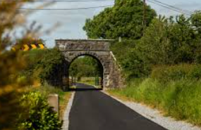
Figure 8.1: Limerick Greenway
8.2.1 Blue/Green Infrastructure
The benefits of well-planned and well-managed Blue Green Infrastructure are manifold. Blue Green Infrastructure provides the benefits and services that we as human beings require to thrive and maintain a quality of life. It is therefore an important consideration in planning for development and meeting the needs of the population as well as protecting and enhancing biodiversity.
BGI has been proven to be a sound investment with returns far higher than the initial investment. BGI should be considered as multifunctional including making space, protecting wildlife, access to nature, recreation and social interaction, reducing flood risk, improving despoiled landscapes and reducing the negative effects of climate change among others.
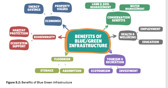
Figure 8.2: Benefits of Blue Green Infrastructure
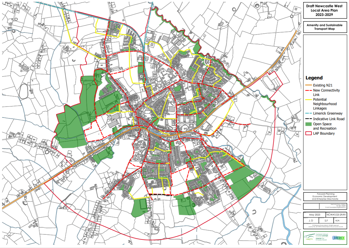
Figure 8.3: Newcastle West Amenity Map
The designation of a riparian buffer does not preclude amenity use of the towns watercourses provided that walkways and cycleways are constructed sensitively and with minimal impact on the riparian environment. There is potential for linear green paths and cycleways along the Daar linking to the Great Southern Trail to the north of the town. Similarly, there is potential for greenways to serve the residentially zoned lands to the southeast of the town along the Dooaly and Arra.
The range of ecosystem services deriving from BGI can be extensive. Table 8.1 below sets out BGI enhancement opportunities in Newcastle West interlinked by a number of key overlapping themes;
- Recreation and Health
- Economic Development
- Climate Change Adaptation and Mitigation
- Biodiversity and Natural Resources
- Sense of Place
- Water Resource and Flood Management
|
Enhancements Opportunities |
Theme |
|
The Demense - already functions very successfully as a Park, providing opportunities for both active and passive recreation. Enhanced utilisation expected, and alternative recreational destinations can be accessed from the GI corridors and linkage to the Greenway. |
Recreation and Health
|
|
Recreation and Health
|
|
Economic Development
|
|
Climate Change Adaptation and Mitigation
|
|
Biodiversity and Natural Resources
|
|
Sense of Place
|
|
Water Resource and Flood Management
|
Table 8.1: Blue Green Infrastructure Enhancements/Opportunities
|
GBI Corridor |
Short-term Priorities |
Possible short term funding |
Long term Priorities |
Potential Funding Sources |
|
River Arra , Demesne, Limerick Greenway |
Connections and access routes using Greenways, Cycle Routes and Green Streets to complete route including improvements to “hard” crossings of trafficked carriageways to create a continuous GI corridor |
Active Travel |
|
External |
|
River Daar |
|
|
Creation of linear Park along River Daar to the east of the town connecting to the Limerick Greenway |
Greenway funding through Smarter Travel |
|
Intra Urban |
|
Smarter Travel Initiative Green Streets External Climate |
Green Streets |
External – Climate Change Adaption measure |
Table 8.2: BGI Implementation Strategy
Objective CHO2 - Blue Green Infrastructure: It is an objective of the Council to:
- Develop and enhance blue and green infrastructure opportunities in accordance with Our Green Region – a Blue Green Infrastructure and Nature-based Solutions Framework for the Southern Region and The Best Practice Interim Guidance Document ‘Nature-based Solutions to the Management of Rainwater and Surface Water Runoff in Urban Areas’ – Inclusion of SuDS and green infrastructure, throughout Newcastle West and in line with the detail set out in Tables 8.1 and 8.2.
(b) Promote connecting corridors for the movement of species and encourage the retention and creation of features of biodiversity value, ecological corridors and networks that connect areas of high conservation value, such as woodlands, hedgerows, earth banks, watercourses, wetlands and designated sites where possible. In this regard, new infrastructural projects and linear developments in particular, will have to demonstrate at design stage, sufficient measures to assist in the conservation of and dispersal of species.
(c) Protect existing ecosystems and biodiversity assets, such as natural woodland, natural watercourses and riparian habitats, layered ecosystems supporting flora, fauna, pollinators, invertebrates, micro-organisms and mycelium, where possible.
(d) Protect Watercourses in Newcastle West by ensuring the provision of adequate riparian buffer zones.
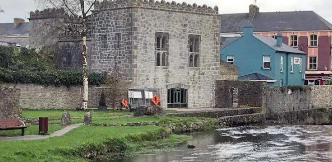
Figure 8.4: River Arra Walkway
8.2.2 Water Framework Directive
The European Union Water Framework Directive (WFD) was signed into law in October 2000. The Water Framework Directive (WFD) brings an integrated approach to managing water quality on a river basin (catchment) basis, in order to protect and enhance both ecological and chemical quality of rivers, lakes, groundwater, estuaries and coastal waters.
The WFD is implemented through River Basin Management Plans (RBMPs) in three six-year cycles. Each cycle providing an opportunity to assess water conditions at different stages and set out actions to achieve water quality objectives. The third cycle runs form 2022-2027.
The Minister for Housing, Local Government and Heritage is responsible for implementation of the WFD in Ireland. The Department of Housing, Local Government and Heritage leads on the development and implementation of national river basin management plans. The Environmental Protection Agency (EPA) leads on the technical expertise and science. Local authorities are responsible for the development and implementation of RBMPs at a local level. LAWPRO is coordinating a nationwide response on behalf of the 31 local authorities. A Key part of the Water Framework Directive is Article 14, which requires all member
states to engage with the people who live work and play in a catchment. Therefore, it is critical that local communities are involved in management and decision making related to protecting and, where necessary, improving their water resources and to help communities to protect and improve a beautiful and diverse landscape with accessible healthy waterways that support local livelihoods, healthy habitats and rich wildlife.
Policy CHP2 Water Framework Directive:
Policy: It is a policy of the Council to:
Implement changes to the management of water bodies, taking account of all aspects of the Water Cycle in accordance with the Water Framework Directive and the principal objective of the Water Framework Directive to achieve at least good status in all waters and to ensure that status does not deteriorate in any water.
The core of the town of Newcastle West, situated in the townlands of Castle Demesne, Churchtown, Gortboy, Rathnaneane and Knockane, is a Recorded Monument, LI 036-067001, classified as a historic town. There are 20 Recorded Monuments contained within the LAP area. There are eleven ring forts in the immediate environs of the town. There is also a medieval church and graveyard (LI036-024001/002) north of the town in the townland of Churchtown. For further details refer to Appendix 1 Map 5 (Recorded Monuments).
The location of each archaeological monument is provided in the Record of Monuments and Places which is maintained and up-dated by the Archaeological Survey of Ireland, a branch of the National Monuments Service. The 1994 Amendment to the National Monuments Act established the Record of Monuments and Places on a statutory basis with a set of maps and a catalogue of sites.
The structures/monuments include earthwork, a water mill, church, castle, graveyard, road/trackway, mill, memorial stone, enclosure and the historic town. Evidence that survives in and around these sites is extremely valuable. Every step to preserve it or at a minimum to recover it, must be taken. The Local Authority will consult with the Development Applications
Unit of the Department of Housing, Local Government and Heritage and other Statutory Consultees when considering applications for planning permission for development on, or in the vicinity of archaeological sites and/or monuments. Appendix 1 Map 5 provides a list of structures in the Sites and Monuments Records for Newcastle West.
Under the provisions of the National Monuments Act Section 12, 1994 Amendment, a person proposing any works (including exempted development) ‘at or in relation to such a monument’ must give two months’ notice to the National Monuments Service. As sites continue to be discovered, some of those found subsequent to the publication (1997) have been included in the Historic Environment Viewer, which is available on the website. There are certain sites in State ownership or guardianship, or have been served with temporary preservation orders. Under the 2004 Amendment to the National Monuments Act, any of these sites or sites deemed National Monuments in the care or guardianship of the Local Authority will require Ministerial Consent for works in their vicinity.
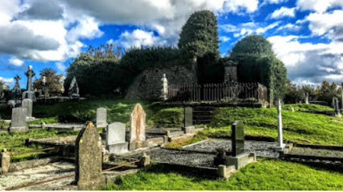
Figure 8.5: The ruins of Saint David’s Church surrounded by the graveyard in Churchtown, north of Newcastle West, Co Limerick (Photograph: Patrick Comerford, 2018)
Objective CH03 Archaeological Heritage:
It is an objective of Council to:
(a) Seek the preservation of all known sites and features of historical and archaeological interest. This includes all the sites listed in the Record of Monuments and Places as established under Section 12 of the National Monuments (Amendment) Act 1994.
(b) Protect and preserve all sites and features of historical interest discovered subsequent to the publication of the Sites and Monuments Record, this includes all sites that may be discovered during the course of excavation or construction.
(c) Protect and preserve all underwater, riverine archaeological sites.
(d) Ensure that any proposed development shall not have a negative impact on the character or setting of an archaeological monument or which is seriously injurious to its cultural or educational value.
(e) The area of a monument and the associated buffer area shall not be included as part of the open space requirement demanded of a specific development, but should be additional to the required open spaces; and
(f) If appropriate, where such a monument lies within a development, a conservation and/or management plan for that monument shall be submitted as part of the landscape plan for the proposal.
(g) Promote awareness of the appropriate adaption of archaeological heritage to climate change as per Government policy ‘Built and Archaeological Heritage – Climate Change Sectoral Adaption Plan’, 2019 Department of Culture, Heritage and the Gaeltacht, Heritage 2030, and Limerick Climate Adaption Strategy 2019 – 2024 and higher level spatial plans.
8.4.1 Record of Protected Structures (RPS)
Limerick City and County Council is obliged to compile and maintain a Record of Protected Structures (RPS) under the provisions of the Planning and Development Act 2000 (as amended). Under the Act, Local Authorities objectives for the protection of structures, or parts of structures of special architectural, historical, archaeological, artistic, cultural, scientific, social or technical interest are a mandatory inclusion in a development plan. The complete list for Limerick City and County is available as Volume 3 of the Limerick Development Plan 2022-2028. Appendix 1 Map 4 of this document provides the Record of Protected Structures located within the settlement of Newcastle West. There are 66 Protected Structures in Newcastle West, 37 of which are also listed on the NIAH.
When considering works, including minor works to a Protected Structure, owners/occupiers are advised to contact the Conservation Officer to ascertain obligations in terms of the proposed development to avoid damage to the integrity of the historical built fabric of the structure. Useful resources when undertaking works on Protected Structures and within their curtilage can be found in the planning leaflets series available on-line on opr.ie, the Department of Housing, Local Government and Heritage Advice Series on buildingsofireland.ie, and the advice and guidance on traditional building skills on heritagecouncil.ie
The National Inventory of Architectural Heritage (NIAH) was established under the provisions of the Architectural Heritage (National Inventory) and Historic Monuments (Miscellaneous Provisions) Act 1999. The purpose of the NIAH is to identify, record and evaluate post-1700 architectural heritage. The Department of Culture, Heritage and the Gaeltacht is responsible for carrying out surveys of the architectural heritage on a county-by-county basis. The NIAH survey is available online at buildingsofireland.ie. Many NIAH structures are also Protected Structures. As with Protected Structures if considering works, including minor works on a NIAH listed building, you are advised to contact the Conservation Office for technical advice.
Objective CHO4 - Architectural Heritage: It is an objective of the Council to:
Preserve, protect and enhance the character of Newcastle West including all Protected Structures and attendant grounds in accordance with the best conservation practice and relevant heritage legislation.
Objective CHO5 - Built Heritage: It is an objective of the Council to:
Promote the protection and improvement of built heritage in accordance with NPO 11 of the Project Ireland 2040, RSES, Limerick Development Plan 2022 – 2028, Section 28 Guidelines, including the Architectural Heritage Protection Guidelines for Planning Authorities.
Objective CHO6 - Protected Structures: It is an objective of the Council to:
- Resist the demolition of Protected Structures, in whole or in part, the removal or modification of features of architectural importance, and design element that would adversely affect the character or setting of a Protected Structure, unless exceptional circumstances can be clearly demonstrated by a suitably qualified professional.
- Protect Protected Structures and attendant grounds in accordance with the best conservation practice and relevant heritage legislation
- Support the re-introduction of traditional features on Protected Structures where there is evidence that such features (e.g. window styles, finishes etc.) previously existed.
- Positively consider proposals to improve, alter, extend or change the use of Protected Structures and attendant grounds so as to render them viable for modern use. Proposed works shall be subject to demonstration by a suitably qualified Conservation Architect or other relevant expert that the structure, character, appearance and setting will not be adversely affected and, suitable design, materials and construction methods will be utilised in accordance with best conservation practice and relevant heritage legislation.
- Promote awareness of the appropriate adaption of built heritage to climate change as per Government Draft Heritage Ireland 2030, the Climate Change Sectoral Adaptation Plan for the Built and Archaeological Heritage, 2019, the Built Vernacular Strategy, 2021, the pending National Policy on Architecture, the Limerick Climate Adaption Strategy 2019 – 2024 and higher-level spatial plans. The Council have regard to the Department of Environment, Heritage and Local Government’s publication on Energy Efficiency in Traditional Buildings (2010) and the Irish Standard IS EN 16883:2017 Conservation of Cultural Heritage – Guidelines for Improving the Energy Performance of Historic Buildings (2017) and any future advisory documents in assessing proposed works on Protected Structures.
Objective CHO8 – Architectural Conservation Areas (ACA’s): It is an objective of Council to:
- Protect, conserve and where appropriate, enhance the ACA’s as identified in Map 4. The design of any development proposed in the Architectural Conservation Area, including any changes of use of an existing building, should preserve and/ or enhance the character and appearance of the Architectural Conservation Area as a whole.
- Proposals for development within the ACA’s shall;
- Reflect and respect the scale and form of existing structures within the ACA’s in proportioning, overall scale and use of materials and finishes, particularly with reference to the street frontages and seek to contribute to or enhance the character and streetscape of the ACA’s;
- Seek to retain/incorporate/replicate exterior features which contribute or enhance the character and streetscape of the ACA’s such as shop fronts, sash windows, gutters and down pipes, decorative plasterwork etc;
- Ensure priority is given to the pedestrian, to inclusive access, and to facilitating the improvement of the quality of the public realm: the latter will include for consideration of the planting of trees in the wider public open spaces, benches for sitting and the articulation of uses through appropriate paving.
The National Inventory of Architectural Heritage (NIAH) was established under the provisions of the Architectural Heritage (National Inventory) and Historic Monuments (Miscellaneous Provisions) Act 1999. The purpose of the NIAH is to identify, record and evaluate post-1700 architectural heritage. The Department of Culture, Heritage and the Gaeltacht is responsible for carrying out surveys of the architectural heritage on a county-by-county basis. The NIAH survey is available online at buildingsofireland.ie. Many NIAH structures are also Protected Structures. As with Protected Structures if considering works, including minor works on a NIAH listed building, you are advised to contact the Conservation Office for technical advice.
UNESCO defines Cultural Heritage as including artefacts, monuments, a group of buildings and sites, museums that have a diversity of values including symbolic, historic, artistic, aesthetic, ethnological or anthropological, scientific and social significance. It includes tangible heritage (movable, immobile and underwater), intangible cultural heritage (ICH) embedded into cultural, and natural heritage artefacts, sites or monuments. The definition excludes ICH related to other cultural domains such as festivals, celebration etc. It covers industrial heritage and cave paintings.
Newcastle West is synonymous with Literary and the Arts. The famous Irish poet Michael Hartnett is from the town and grew up in the Maiden Street area. A Literary & Arts Festival, commemorating the late poet takes place annually. Over four days and nights of the festival, the town that was home to and helped shape the late poet Michael Hartnett, plays host to a wide range of talented poets, writers, musicians, singers and artists in a packed programme of exciting and engaging events.
Contents
Observations
Observations
A Chara,
Please find attached Heritage Related recommendations for the above mentioned planning application.
Regards
Diarmuid...
Dear Sir/Madam,
Please find attached the OPW Flood Risk Management submission for the Draft Newcastle West Local Area Plan.
If further...