Chapter 6 - Kilmallock: Appreciating archaeological, built, natural and cultural heritage
The planning policy for heritage is to:
a) Use the legislative powers and functions under the Planning and Development Act 2000 (Amended), and other relevant ancillary legislation to protect archaeological, built, natural and cultural heritage to safeguard heritage for future generations, and
b) Support other agencies, and the local community to conserve, protect, preserve or evolve heritage assets so that they can compete with modern challenges and demands.
c) Ensure European directives and national planning legislation are satisfied in determining the effects of the plan on Kilmallock’s environment, and having determined whether the plan has significant effects on the environment.
6.1 The importance of archaeological, built, natural and cultural heritage
According to the Heritage Act 1995, the national heritage of Ireland includes monuments, archaeological objects, heritage objects, architectural heritage, flora, fauna, wildlife habitats, landscapes, seascapes, wrecks, geology, heritage gardens and parks and inland waterways. Heritage can also be less tangible, for example local history, folklore, place names, culture, collective memories, traditions, historic documents, language, rituals, symbolism, fashion, literature, song and music, spiritually and genealogy. It consists of objects, structures, and processes/traditions passed from generation to generation as they have a distinct historic, social, cultural or environmental value.
Heritage is a very important facet of the community, contributing to a sense of identity and place, and it is important that our rich heritage is available for future generations to appreciate. In terms of planning, this LAP is concerned with archaeology, built heritage, natural heritage and cultural/creative space. There are many diverse forms of heritage in Kilmallock, which have unquestionable social and education value, underestimated economic potential, and make an important contribution to community pride and sense of place. The Council and the wider community see heritage as more than a legacy of the past, or of nature, but as a non-renewable asset meriting appreciation, sustaining, evolving with modern contemporary life. [23]
This plan informed by a number of national policy documents including NPF, Policy on Architecture 2009 – 2015 – Towards a Sustainable Future: Delivering Quality within the Built Environment, the Architectural Heritage Protection Guidelines for Planning Authorities (2011), and any subsequent document. At a regional level, the plan is informed by the draft Southern RSES for the Southern Region, Heritage Council resources, and at a local level the plans published by the Kilmallock Association of Trade and Commerce and Kilmallock Partnership, Limerick Economic and Community Plan, and the Kilmallock Community Plan, the Kilmallock Walled Town Conservation and Management Plan, the Kilmallock Public Realm Plan and the County Development Plan 2010 – 2016 ( as extended).
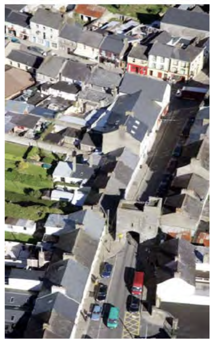
Figure 6.1 View of Kilmallock town and landmark buildings taken for the Kilmallock Public Realm Plan
6.2 Archaeological significance of Kilmallock
The value of archaeological sites and monuments in Kilmallock is recognised by the Council as areas of archaeological importance. Where development proposals coincide with areas of archaeological potential, the planning application will be referred to the National Monuments, Department of Culture, Heritage and the Gaeltacht for their recommendations. Their observations and those of other interested bodies will be considered by the planning authority when assessing the development proposal.
Such is the significance of archaeology in Kilmallock, the centre of the town is designated a Recorded Monument LI047-02 classified as a historic town by the National Monuments Service and is afforded legislative protection under the National Monuments Acts 1930 – 2004. [24] The town defences, the Dominican Priory, King’s Castle, the Medieval Merchant’s House and the Collegiate Church are also National Monuments. Kilmallock is part of the Irish Walled Towns Network established by the Heritage Council in 1995. Conservation works and management of the town wall is guided by the Kilmallock Town Walls Conservation and Management Plan, published by the Council and the Heritage Council, [25] and National Policy on Town Defences, (DEHLG, 2008). The burgage plots are also an important medieval feature of Kilmallock town. The Kilmallock Walled Town Public Realm Plan 2009 also has a role in the archaeological heritage of Kilmallock town.
Archaeological assessments by a suitably qualified archaeologist will be required as part of the planning application process, and monitoring of works in RMPs, including the town centre. The cost will be borne by the developer. Applicants will be required to define a buffer area or area contiguous to any monument to preserve the setting and visual amenity of the site. The area of the monument and the buffer should not be included as part of open space requirements of residential developments, and should be additional to the minimum open space standards as established by the Development Plan.
Under the National Monuments (Amendment) Act, 1994 exempted development under the Planning and Developments Act 2000 (Amended) does not apply within the area of the Record of Monuments and Places. Under Section 12 (3) of the 1994 Amendment Act, any person who wishes to carry out any work at or in relation to an RMP, including development that does not require planning permission, and general ground disturbance, must seek the agreement of the Commissioners of Public Works, and provide at least two months notice in writing. Viewsheds [26] of National Monuments will be a key consideration when assessing planning applications in the town in the interest of protecting the integrity and setting of the monuments.
Objective H1 Archaeological Heritage
It is the objective of the Council to:
- Safeguard the value and setting of archaeological remains and monuments in Kilmallock;
- Protect and enhance the town walls and their setting, and implement of the policies and objectives of the Kilmallock Town Wall and Conservation Plan, 2009. A buffer zone prohibits any development within 15m and any standing development within 20m of the town walls, including the interior of the town walls. In the areas to the interior of the wall and were there are existing structures close to the wall, redevelopment proposals will open access to the walls. On the exterior to the east town wall a buffer prohibiting development on the land extending to the river bank;
- Support the policies and objectives of the Kilmallock Public Realm Plan, and Kilmallock’s membership of the Irish Walled Towns Network and the Walled Towns Friendship Circle;
- Refer planning applications within the RMP including all applications within the vicinity of the viewshed of the Dominican Priory, the Collegiate Church, King’s Castle, Merchant’s House to the National Monuments Service and the Office of Public Works.
- Require within the area of the RMP all development proposals requiring planning permission to archaeological impact assessments as further information;
- Seek the preservation of archaeological remains in situ or, and only where appropriate, through archaeological excavation;
- Provide guidance to property owners and developments regarding the archaeological implications of proposed works or development;
- Facilitate pre-planning consultations in relation to archaeology
- Promote public awareness of the rich archaeological heritage of the town and
- Require archaeological monitoring outside the area of the RMP on development proposals where the scale and nature of such developments may, in the opinion of the planning authority, have a negative impact on previously unknown archaeological remains/artefacts.
Applicants are advised to consult with archaeological maps to ascertain if development proposals are located in areas pf archaeological potential. Refer to Appendix 3 of this plan.
- Where a development site coincides with these areas of archaeological potential the planning application will be referred to the DAHG for their recommendations.
- Where it is deemed that the archaeological heritage will be affected by a proposed development (due to location, scale, nature, materials etc.) the planning authority will require an archaeological assessment.
- Archaeological monitoring will be required where the scale/nature of the proposed development, in the opinion of the planning authority, have a negative impact on previously unknown archaeological features/artefacts.
- Applicants will be required to define a buffer area or area contiguous with any monument to preserve the setting and visual integrity of the monument. This buffer will not be included as part of the open space requirements.
6.3 Kilmallock’s Town Walls, the Area of Special Control (ASC) and Protected Views
(i) Town Walls
The town walls are one of Kilmallock’s greatest asset from an archaeological perspective - a non-renewable asset and an asset of national and international significance. The medieval walls need to be protected and enhanced for the benefit of future generations. Significant investment has been made on the conservation work to the wall as guided by the Kilmallock Town Walls Conservation and Management Plan. The main objective is to stabilise the walls and to prevent further decay and damage, and to allow research into long-term permanent improvements.
Public realm works have enabled the community to appreciate the historic monument from a new pedestrian walkway from the town centre to the national school. The buffer zone established by the 2002 LAP and the 2009 LAP is intended to:
“Prohibit the construction of a building within 20m of the town wall and any other development within 15m of the wall”.
In addition, the buffer will be extended on the exterior of the west wall for 40m from the exterior wall face and on the east wall as far as the River Loobagh. The buffer zone should be managed for both defined access to proposed walks around the walls, for increased provision of managed green space and for habitat development.
Objective H2: Kilmallock Town Walls and associated public realm
It is the objective of the Council to:
- Seek opportunities to continue the progress Kilmallock Walled Town Public Realm Plan (2009) and the Kilmallock Walled Town Conservation and Management Plan (2009) as both remain relevant to the sustainable development of the town walls, and the protection, conservation and appropriate management of this historical heritage asset.
- To improve public awareness and increase knowledge and appreciation of the town walls and their significance at local, regional, national and international levels;
- Promoting a high degree of physical and intellectual access to the town walls and meeting the needs of a broad variety of users;
- Develop interpretation to encourage understanding of the principal features of the walls, and facilitate access to information; and
- Develop the range of educational provision for schools and other groups, as an important element in interpretation and the promotion of access.
(ii) Special Control Area
In recognition of the special character of the open spaces located to the north east of the town, as an important setting to the Collegiate Church and the Priory, and to the west of the town centre between the western walls and the Ash Hill woodlands, the lands are designated as a Special Control Area (SCA). The designated areas will be protected free from development to maintain their open character and visual amenity. It is the objective of the Council to protect the integrity and appearance of the area and to ensure that any development proposals within areas of high natural and historical value shall:
- Have regard to the Town Walls Conservation and Management Plan;
- Contribute to or enhance the environment and character of the SCA;
- Do not include measures that will detract from the overall qualities of the SCA area; and
- Protect any natural features or landscape elements that contribute to the area’s special character.
There will be a presumption against development that may detract from the special architectural, archaeological, historical, social, cultural and ecological character of the zoned area and the important amenity that it provides.
Objective H3: Special Control Area
It is the objective of the Council not to permit future development in the Special Control Area (SCA), other than leisure/tourism development, which complements the use of the town walls, and the historical buildings and the natural amenities located within these zones. Amenities defined in the Public Realm Plan such as walkways along the town walls will be generally permitted.
(iii) Protected views/viewsheds
The approach from the Bruff/Limerick road provides a fine view of the Dominican Priory, the Peter and Paul’s Church, and an important glimpse of the medieval core of the town. It signifies a sense of arrival in an historic place. The eastern views over the town walls and the open spaces identified as a Special Control Area, and the view over the western walls, provide an important overview of the general setting of Kilmallock, and highlight its status as a walled town. Such views are mostly associated with the open space pattern of Kilmallock, which provides an appropriate foreground and setting to the many historic buildings and monuments within the town. Eastern and western views over the town walls are of particular importance in terms of appreciating the special landscape and heritage context of the town and its rare walled town characteristic. There will be a presumption against development in these sensitive areas, except that which is required in relation to appropriate tourism and related activitie, and where appropriate, the Council will exercise a high level of control (layout, design, siting, materials used, landscaping). In such areas, site-specific designs are required, and in areas outside these delineated areas, high standards of design and subsequent management will be required.
Objective H4 Kilmallock’s Protected Views/Viewsheds
It is the objective of the Council to safeguard the scenic views and prospects by controlling development proposed within the viewsheds of the town walls and national monuments, particularly across open spaces close that contribute to the settings of these structures. In particular, the Council will seek to maintain views:
- from the Bruff/Limerick road over the townscape;
- from the Proonts/Coolroe road over the eastern town walls, the Dominican Priory and the Collegiate Church;
- from the Wolfe Tone bridge over the open spaces of the Special Control Area; and
- from the Glenfield Road over the western town walls.
6.4 Built heritage of Kilmallock
Killmallock has a rich chronology of built heritage, which is generally intact surviving many centuries. This section refers to post-1700 structures. The collective arrangement of the 19th and 20th buildings of traditional vernacular architecture on Kilmallock’s streetscape, is largely intact reflecting Kilmallock’s history as an important regional institutional and civic centre. Contemporary architecture is also represented in Kilmallock with the construction of the sensitively designed modern Kilmallock Library, and the recent extension to the post-primary school and the redeveloped national school.
In recognition of the importance of the integrity of Kilmallock’s built heritage, there are a number of mechanisms offering legislative protection under the Planning and Development Act 2000 (Amended), and the Architectural Heritage (National Inventory) and Historic Monuments (Miscellaneous Provisions) Act 1999. These mechanisms include the list of structures, in the National Inventory of Architectural Heritage [27], the list of Protected Structures under Part IV of the Planning and Development Act 2000 (as amended), and the designation of an Architectural Conservation Area in the town core by the Council in the Limerick City and County Development Plan 2010 – 2016 (as extended).
(i) National Inventory of Architectural Heritage (NIAH)
The National Inventory of Architectural Heritage (NIAH) is administered by the DCHG and was established on a statutory basis under the provisions of the Architectural Heritage (National Inventory) and Historic Monuments (Miscellaneous Provisions) Act 1999. Its purpose is to identify, record, and evaluate the post-1700 architectural heritage of Ireland, uniformly and consistently to assist the protection and conservation of the built heritage. The NIAH provides the basis for the recommendations of the Minister for Culture, Heritage and the Gaeltacht to the planning authorities. It is also a research and educational resource, raising public awareness, interpretation and appreciation of post – 1700 architectural heritage. The Council of Europe's definition of architectural heritage allows for the inclusion of structures, groups of structures and sites considered significant in their own right, or are of significance in their local context and environment. Within the LAP boundary there are 58 structures listed on the NIAH. These include cast-iron post boxes, bridges, buildings and memorials.
(ii) Record of Protected Structures (RPS)
The Planning and Development Act 2000 (Amended) requires each planning authority to compile and maintain an RPS in the interest of safeguarding of heritage interest. [28] The RPS is a mechanism for the statutory protection of the built heritage and forms part of each planning authority's development plan. The Minister for the Culture, Heritage and the Gaeltacht may recommend structures to the planning authorities for inclusion on the RPS. There are 68 structures within the LAP boundary listed as Protected Structures in the RPS by the Council. Refer to Appendix 2 of this plan. As the Planning Act allows a Planning Authority to make additions to or deletions from the RPS, the most recent edition of the RPS contained in the CDP should be consulted. Exempted development provisions are not applicable to such structures where proposed development would materially affect the character of the structure, or any element of the structure that contributes to its special interest. Further advice includes the national guidance document Architectural Heritage Protection - Guidance for Planning Authorities (2011) and the various publication in the Advice Series which gives practical information on the care of older buildings, and the various elements that constitute their unique, distinctive, traditional fabric.
Those considering works on a Protected Structure or within the curtilage of a Protected Structure should contact the Conservation Officer in the Council for guidance. In the case of a protected structure any works which would materially affect its character will require planning permission. Legal protection also extends to the interior of the building and to other structures and features within the curtilage of a protected structure, such as outbuildings, boundary walls, paving, railings, etc. Owners or occupiers of Protected Structures are strongly advised to apply, in writing, to the Planning Department for a declaration under Section 57 of the Act to identifying works that would, or would not, in the opinion of the planning authority require planning permission. There is an opportunity to appeal the decision of the planning authority to An Bord Pleanala. If an owner or occupier is in any doubt about particular proposed works, the Conservation Officer in the Council should be consulted. If planning permission is required for the proposed works on a protected structure or a proposed protected structure, or within the ACA some additional procedures and detailed information will be required as part of the planning application process. The applicant will be required to submit photographs, plans and particulars to show how the proposed development would affect the character of the structure. Refer to Appendix 2 of this LAP for further guidance.
Objective H4 Protected Structures and listing on National Inventory of Architectural Heritage (NIAH)
It is the objective of the Council to:
- Protect structures listed on the Record of Protected Structures, and structures proposed to be entered onto the RPS,
- Encourage the appropriate re-use, conservation/restoration of these structures, and use of appropriate materials in the proposed works,
- Require sensitive development proposals within the curtilage of these structures, and protect the viewshed of these structures.
- Consider the list of the NIAH when assessing proposed developments.
The Council shall resist:
- Demolition of Protected Structures, in whole or in part;
- Removal or modification of features of architectural importance; and
- Development that adversely effects the setting and visually integrity of these structures.
(iii) Architectural Conservation Area
Part IV of the Planning and Development Act 2000 (Amended) provides for the establishment of Architectural Conservation Areas (ACAs). While provisions for Protected Structures as discussed above are concerned with a structure and its curtilage, and ACA protects the collective impact of a number of structures relative to one and other, and the impact of proposed works, in terms of visual impact, for example a street terrace and its streetscape. As with Protected Structures, the designation of an ACA is not just concerned with the physical preservation of the built heritage and the unique character of an area, it is also concerned about; keeping precious building crafts and knowledge alive; encouraging, in an era where there is increasing awareness of the threats to our environment, a building culture centred on sustainability; and providing insights to earlier ways of life. Research has proven there is an economic value to Ireland’s historic environment [29]. Globally, it is recognised that conservation-led regeneration in towns and villages can contribute to investment by retaining businesses and people in the area and by providing an incentive to relocate into it. This builds community and increases business confidence. Effort expended in maintaining and enhancing ACAs can stimulate economic activity, the provision of jobs, training opportunities in skilled traditional crafts and trades.
Designation of Protected Structures and the ACA assists the preservation, enhancement and continuing regeneration of Kilmallock. The protection of individual buildings, their curtilage, and the creation of the Architectural Conservation Area in the town centre provide the following benefits:
- Provides a focus for civic pride in the history and architectural heritage of Kilmallock;
- Creates a framework for the protection of the town’s tangible cultural heritage and provides guidance for property owners and developers to ensure that future change respects the character of Kilmallock;
- Instils a sense of confidence and awareness among property owners and provides an opportunity to build upon the distinctive character of Kilmallock with potential for increased tourism, trade and employment in the area; and
- Encourages, in practical ways, opportunities for built heritage conservation by making available advice, and funding from the Council’s Architectural Conservation Office, for community initiatives aimed at the enhancement of property and public spaces in ACAs.
Works to protected structures and in Conservation Areas must retain existing surviving elements, aim to re-instate lost elements or character, with new build complementing the original streetscapes, building lines and open areas.
(iv) Kilmallock’s ACA
The collective arrangement of buildings on Sheare’s Street, Emmet Street, Lord Edward Street, and Wolfe Tone Street are visually impressive on the traditional streetscape, which is largely intact to the present day. Plots are generally narrow with direct front access from the building onto the street. Some distinctive features include classical proportions of windows and doors, natural slate roofs, carved timber traditional shopfronts (Lynch’s Pub), cast-iron rainwater goods, rendered walls, quoins and plinths. The architectural diversity of Kilmallock demonstrates a number of genres from Gothic Revival and Elizabethan references on the bank buildings to the simple proportioned cottages on Wolfe Tone Street, to the modern contemporary style of the Kilmallock library.
New developments proposed within the Architectural Conservation Area, should respect the existing building lines and the historic form of those buildings. Proposals for new buildings should not seek to dominate the historic core and should respect the historic fabric of the buildings and the morphology of their plots. Contractors should ensure that the appropriate permissions, consents, and compliance documentation are in place prior to commencing works.
It is considered best practice in the field of architectural conservation that extensions to historic buildings should be contemporary in design- allowing the development history of the structure to be clearly read. This approach should also be considered when preparing proposals for new build and developments in Kilmallock, having regard to existing building lines and the town’s evolved character. The contemporary modern design of the Kilmallock Public Library respecting the historic Kilmallock Court House and the former Kilmallock Workhouse is an exemplary example of well-designed new build complimenting the historic building, and facilitating a purpose/use for a Protected Structure.
Investing in both contemporary and historic built heritage is a driver of physical, social and economic regeneration and requires the development of a culture of ‘quality’ to permeate all strands of civic society. Limerick City and County Council is guided by national policy as contained in the Government Policy on Architecture 2009 – 2015 – Towards a Sustainable Future: Delivering Quality within the Built Environment, the Architectural Heritage Protection Guidelines for Planning Authorities (2011), and any subsequent document. Property owners and their agents should refer to the listing for their building on the NIAH, and the NIAH Handbook 2017 as they provide succinct records of detail of the structure and highlight distinguishing plan, elevational features and architectural style. Appendix 2 also provides guidance.
Objective H5: Kilmallock’s Architectural Conservation Area (ACA)
It is the objective of the Council to protect, conserve and where appropriate, enhance the ACA as identified in Map 3.
Proposals for development within the ACA shall:
- Reflect and respect the scale and form of existing structures within the ACA in proportioning, overall scale and use of materials and finishes, particularly with reference to the street frontages and seek to contribute to or enhance the character and streetscape of the ACA;
- Seek to retain/incorporate/replicate exterior features, which contribute or enhance the character and streetscape of the ACA such as shop fronts, sash windows, gutters and down pipes, decorative plasterwork etc;
- Ensure priority is given to the pedestrian, to inclusive access, and to facilitating the improvement of the quality of the public realm: the latter will include for consideration of the planting of trees in the wider public open spaces, benches for sitting and the articulation of uses through appropriate paving.
(v) Kilmallock’s unique design considerations for infill or replacement buildings in town centre
Developing knowledge about your historic building is perhaps the best and most important step to successful renovation/restoration works for longevity and long-term investment. Knowing what makes your building special and authentic to Kilmallock is a valuable baseline from which to work. While your building may not be listed, neighbouring buildings may be listed and their text may provide some insight to your building. This groundwork assists informed decision plans for refurbishment, appropriate repair of damaged or decayed elements, and appointing builders, specialist crafts people, surveyors and architects.
While the majority of buildings in Kilmallock are not designed by architects, but they were built by local builders and craftspeople who were often influenced by architectural styles and incorporated features into Kilmallock’s buildings. References to medieval styles, the Victorian, Edwardian, pre-war and post war eras can be found in Kilmallock.
Some features that define a character of a building or collectively buildings on a streetscape include:
- Scale, proportion of windows and doors, roof to wall ratios
- Design of roof, pitches, gables, chimneys, rain water collection system,
- Style original openings such as sash or casement windows, panelled doors, glazing on windows and doors such as stain glass, fanlights,
- Decorate features such as quoins, carved shop fronts, stucco detail
- Distinct craft techniques such as stone masonary, carving, decorative plastering, and rendering, iron-cast rain water goods.
Context of buildings
The insertion of a new building into the traditional Kilmallock townscape, or the replacement of an existing building that is beyond renovation and re-use, requires a very sensitive and skilled approach. Any new development needs to contribute positivity to the character and identity of the town centre. The emphasis in designing and considering new proposals should be on achieving good quality urban development that reinforces the existing compact urban form, makes effective use of prime centrally located land and contributes to a sense of place by strengthening for example the street pattern or creating new streets.
Figure 6.2 Compact urban form in the town
Applicants for an infill or building replacement scheme in the town centre will need to demonstrate clearly and simply a thorough understanding of the site’s context.
The most important consideration will be the relationship of the new building to its neighbours and to the pattern of the streetscape.
Appropriate responses need to take full account of historical plot widths, building heights, established building lines, the nature of specific boundary conditions (such as historic walls), door and window openings, roof profiles, materials or other distinctive features. In all cases, the construction of a new building within 20m of the town wall, and any other development within 15m of the wall, will not be permitted.
In terms of the context of a building a successful project will:
- Relate well to the history of the place;
- Sit in the pattern of existing development and routes through and around it;
- Respect and where possible enhance important views;
- Respect the scale of neighbouring buildings;
- Use materials and building methods which are as high in quality as those used in existing buildings; and
- Create new views, juxtapositions and contrast which add to the variety and texture of the setting.
The density of new infill development should respond to the immediate context of the site. As this will vary, and as new development will be likely to include mixed uses, it is not possible to be prescriptive about the level of density to be achieved. For new apartments, reference should also be made to the Design Standards for New Apartments (2018), which are intended to ensure that the design and layout of new apartments provide satisfactory accommodation for a variety of household types and sizes.
Plots and archways
Traditional plot widths in Kilmallock are long and narrow – a legacy of medieval Kilmallock and are known as burgage plots. Burgage plots generally extend from the street to the town wall, or in the case of Sarsfield Street to Orr Street. Consequently, this influences the dominant narrow facades on the streetscape. Larger buildings are difficult to integrate into this historic pattern. Every effort should be made to respect the historic urban plot. Archways provide access to the rear of buildings. Decorative keystones provide distinctive architectural detailing and should be respected in any development proposal.
The following guidance should be part of any redevelopment proposal in the town centre:
- New build/infill should respect the burgage plot.
- In the event of plot amalgamation to accommodate new development the historic plot should be reflected in the design and indicated by a feature of the redesign proposal. A good example is the historical references and demarcation of plot boundaries in the Supervalu store.
- Narrow street frontages should be maintained.
- Access to facilitate parking, storage should be from the main street or through archways and not from rear access routes.
- Surviving historic boundary features should be incorporated into the redevelopment.
- Archways shall remain proportional to the scale of the front façade.
Building lines and heights
Building line refers to the position of a building in relation to the street edge. The traditional building lines of the town centre consistently follow the edge of the footpath away from the road surface. In Kilmallock, they gradually curve with the street alignment which contributes to public realm, streetscape views, and gives a sense of visual enclosure and scale. Where the building line has been interrupted, for example east of King’s Castle, the streetscape becomes less coherent. The building lines of the town are generally uniform. This distinctive building line should be adhered to by future development.
Figure 6.3 Traditional building line in Kilmallock
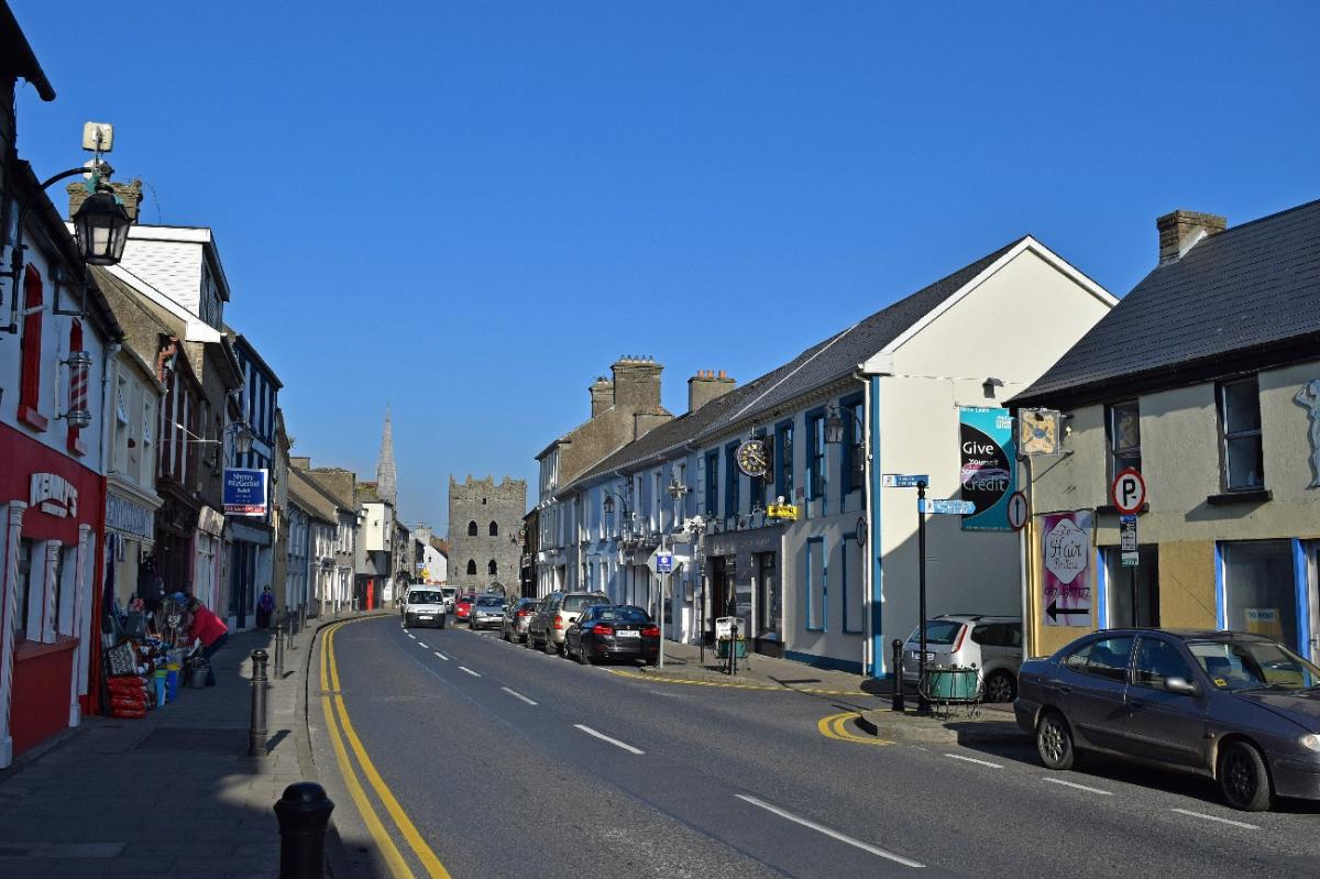
Building height is not consistent in the town centre ranging from 1 to 3 storey buildings. For new development, the proposed building height should reflect those building in the immediate vicinity respecting the historic street facades.
Roofs, windows and doors
The roof is an important element that contributes to the aesthetics of Kilmallock’s streetscape. The cumulative visual impact of the design of gables, hips, parapets, roof slates, chimney details contribute to public realm. Loss of natural slate in favour of modern synthetic roof material can radically alter the appearance of old buildings. The roofscape is particularly important in Kilmallock, as it is viewed at a distance as you approach the town, in particular from the north.
The following are design guidelines for roof works, windows and doors, in the town centre will apply:
- The roof profile (40-45 degree), structure, cladding, and detailing should reflect adjoining buildings.
- The roof profiles will not be interrupted by dormer windows, mansard roof, or the insertion of mechanical plant rooms, or decorative ridge tiles.
- Large areas of glazing or openable roof lights onto prominent roof slopes should be avoided, particularly if the building is part of a terrace.
- Eaves should be flush with walls below, or possibly with a projecting stone or brick course at the head of the all to support eaves gutters.
- Natural slate double pitch roofs should be used – roofs which have a larger span are unlikely to be suitable in Kilmallock.
- Use of steel, aluminium or plaster rainwater goods and associated fittings should be avoided.
- The solid to void relationship on the front façade should be carefully considered and vertically, proportional in terms of wall to roof area,
- Porches, dormers, and bay windows are generally not appropriate to the town centre. Openings should be recessed.
- Window and door frames should generally be of painted timber as the use of uPVC or aluminium frames degenerate the historical fabric of the town.
- Careful consideration of fanlights/overlights can be suitable decorative features providing natural light to buildings.
Materials
Building materials in older structures tended to be sourced locally as much as possible. Consequently, they are a unique indicator the expertise local craftspeople. Traditional techniques using natural materials such as natural slate, wood, limestone blocks and lime mortars were used for their natural ventilation properties and allowed building to ‘breathe’. Loss of traditional materials in favour of modern materials such as cement, synthetic roof tiles, PVC windows, doors, eaves and fascia can radically alter the appearance of an old building, but can also cause longterm material damage in terms of sealings, ventilation and dampness. These artificial materials should be avoided. Attention should also be given to rainwater goods as traditional techniques used such as wrought-iron surface water systems were forged and beaten by hand, and cast iron goods were moulded. Similarly, glazing was prepared by craftspeople and often has unique finishes demonstrating authenticity.
Wherever possible, natural materials that are more sustainable should be used in the town centre and the Council encourages creative use of natural products, appropriately. New materials and techniques should only be used where they have proved themselves over a sufficient period and where the traditional alternative cannot be sourced. Contemporary buildings should incorporate timber, glass, natural slate, and stone into design but random mixes of stone, cement and brick should be avoided.
The colour finish of buildings should blend with adjoining buildings. Bold, vivid and generally dark colours should be avoided.
Some of the features of merit in Kilmallock, and the appropriate palette of traditional building materials for the town are as follows:
- Fabric - Limestone, bound with lime mortars
- Roofing - Natural Slate, with certain exceptions found in some instances
- Rainwater Goods - Cast iron or galvanised sheet iron
- Windows - Primarily rise and fall timber sash windows of varying patterns and designs, with some exceptions
- Finishes - Painted lime renders of varying consistencies, often with stucco detailing at returns, along floor lines and roof level, and on window or door opes; Alternatively either well-worked or quality rubble stone, with appropriate joints in both cases were left bare or were or have had multiple layers of lime wash applied over the generations.
Shopfronts
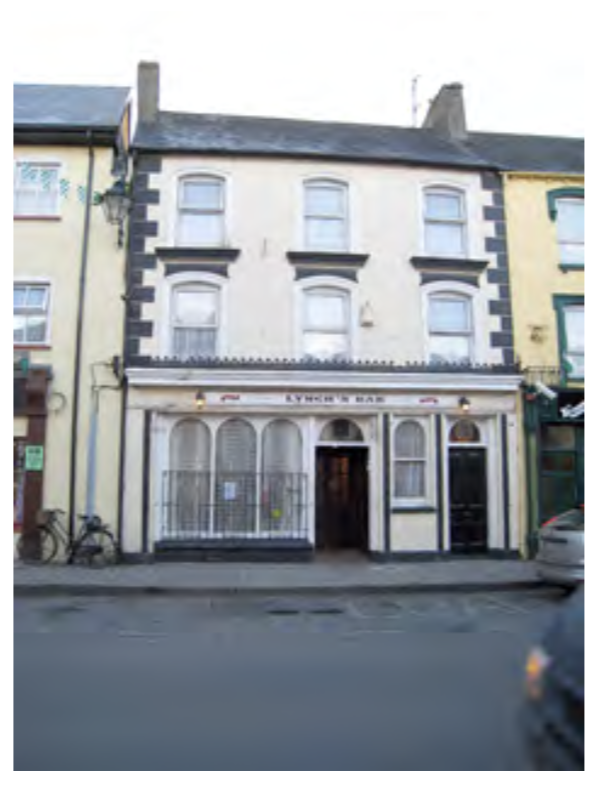
Original shopfronts and their unique elements such as fascia board, brackets, glazing bars, carved details on wooden frames, doors, glazing add considerably to Kilmallock’s architectural heritage. Lynch’s pub is a fine example of a traditional shop front with pilasters, timber fascia, cast-iron sill guards, and tripartite window design with carved spandrels.
Figure 6.4 Traditional Shopfront
Where shopfronts are proposed as part of redevelopment they should respond with the traditional style. Shop front elements should have vertical emphasis. Columns or pilasters should be of suitable plaster or timber capable of taking the weight of fascia, and wall above and may have decorative fluting, carved panels or plan surface based on a plinth. Openings should be recessed.
When opportunities arise, the original elements of the shopfront should be incorporated into the new design as a means to sustain local craftsmanship. Where the original shopfront survives the details should be prepared as necessary with specialist knowledge. Where shopfronts have been altered, badly maintained, or inappropriately altered with unsuitable material every effort should be made to reinstate traditional elements.
Advertising on shopfronts
Signage on shopfronts can detract considerably from the building, and the streetscape. The collective presences of poor signage on a number of businesses on a street give be poor impression of the town. The Council will control advertising signs in relation to their design, purpose, materials particularly in the ACA. The following should be considered with addressing shopfront signage and advertising:
- Advertising signs are not permitted where they obscure road signs, or interfere with public safety and road safety
- Sign should be simple in design and sympathetic to the building its surroundings.
- They should not obscure architectural details and are not permitted above eaves, parapet or roof level.
- Traditional painted sign writing and solid individual lettering is encouraged, as is traditional or wrought iron hanging signs. The use of neon, plastic, PVC, perspex or flashing lighting, reflectorized or glitter finishes/effects are not permitted on the streetscape.
- Projecting signs, banners and flagpoles are restricted in terms of size and number to avoid clutter
- Freestanding hoardings are not suitable in the interest of pedestrian movement, and the movement of less able people, for example the visually impaired, or those using prams/buggies.
6.5 Cultural Heritage
The characteristic of cultural heritage can permeate architectural heritage and can, in the broadest terms, include aesthetic, historic, scientific, economic or social values of past and present generations. The NIAH includes a cultural interest and artistic interest in their classification of buildings listed of heritage importance. [30]
Kilmallock has a proud, rich history and heritage that has informed its culture. Kilmallock has a rich cultural heritage and is very fortunate to have the cultural presences of the Friar’s Gate theatre and the library in the town providing contemporary arts, performance and visual arts, and enhancing the artistic experience for the wider South Limerick area through drama, performances, workshops, outreach programmes, and exhibitions. Kilmallock is also steeped in traditional GAA sports.
Limerick City & County Council published the Limerick Cultural Strategy - A Framework 2016 – 2030 following a public consultation process. This aims to grow Limerick’s cultural capacity by retaining and attracting creative practitioners to live and work in Limerick, to place culture at the heart of the economic growth and regeneration of Limerick; to engage citizens through involvement in culture growth and regeneration of Limerick and to increase and support the role of the creative industries in Limerick. Cultural events are key enablers to promoting and attacting people to the town. At a local level, the Council sees a similar role for cultural opportunities in Kilmallock.
Objective H6: Cultural Heritage
It is the objective to the Council to:
- Seek and support opportunities to implement the aims and objectives of the Limerick Cultural Strategy 2016 – 2030 in Kilmallock.
- Recognise the valuable contribution of creative communities and practioners to economic growth, tourism, creative place-making, community development and well-being for the citizens of Kilmallock and its hinterland.
6.6 Natural heritage and Climate Change
Kilmallock supports a number of urban habitats, including ecosystems associated with the River Loobagh, open field and hedgerows, mature trees, green spaces by the Town Walls, the new Glen Wood, an urban woodland development by the local community, the Famine Memorial Park, and open spaces around the Priory and Collegiate Church. Hard surfaces including the Town Wall also support habitats and ecosystems, as does older buildings, for example structures can provide roosting sites for bats. A number of trees, woodlands and hedgerows are identified by this plan in the interest of rich biodiversity. These features will be incorporated into development proposals and tree/hedgerows surveys will be required when seeking planning permission. Refer to Appendix 1.
There are no European or national designated ecological sites (Special Protection Areas – SPAs, Special Areas of Conservation - SACs, Natural Heritage Areas – NHAs) located within Kilmallock. There are no records of rare or protected species in Kilmallock.
There are a number of impressive tree groups and hedgerow that merit conservation as indicated on the Amenity Map in Apprendix 1. These trees and hedgerows include Beech, Ash, Alder, and the trees planted by the local community in Glenfield Wood, and example of an urban woodland development by the local community and the Council.
Objective H7: Tree Protection and Nature Conservation
It is the objective of the Council to:
- Protect natural stone boundary walls and mature trees/hedgerows. Development that requires the felling or harming of such trees shall not normally be permitted unless otherwise supported by a tree survey report establishing that the subject trees are of no ecological or amenity value. Refer to the Amenity Map in Appendix 1. Such report shall be undertaken by a suitably qualified and competent person.
- Future development proposals will be required to demonstrate planting of native deciduous species as part of the planning application.
- All development activities governed by the plan shall be carried out in accordance with the provisions of the EU Water Framework Directive and associated regulations and guidance documentation including the Shannon International River Basin Management Plan 2009 – 2015 and any subsequent documents.
Climate change is linked to the production of greenhouse gases, such as carbon dioxide and chlorofluorocarbon, often produced from human sources. While natural variations in climate do occur these have added to by the effects of human activities. Achieving a low carbon producing economy and society requires, where practicable, everybody seeking to efficiently, meet resource requirements from indigenous local resources. Those indigenous resources should be harnessed to optimum potential in order to meet or exceed local needs, having due consideration for national targets and the local planning guidelines. This involves not just the use of local resources where applicable but the adoption of new building techniques and designs which will minimise energy intensive inputs. Development proposals which incorporate these issues will be encouraged by the Council. The Council, in its preparation of plans has a role to play in adaptation for climate change. Small actions, when viewed cumulatively can often make great differences.
Zoning
Promoting land use patterns and economic activity that minimises effects on climate change is an objective of Limerick City & County Council. As part of this objective the Council will endeavour to promote responsible development and management of land, drainage systems and natural habitats and the local delivery of energy, efficiency and adaptation to climate change in Kilmallock. The plan, through its zoning template, has tried to include the maximum amount of relevant land use zonings for a town the size of Kilmallock. By trying to accommodate as wide range of land uses as possible within the zoning matrix, this will allow for diverse uses, which can cater for the needs of the town to encourage biodiversity and ecology in the town.
Closely related to zoning is the issue of flooding. To guard against flooding the land around the River Loobagh, which runs through the town, has been designated as green space. This also has the advantage of preserving the settings of the archaeological monuments in this area. It also has the advantage of ensuring a continuous habitat corridor through the town.
Renewable energy
While changes to planning regulations in 2011 has resulted in new thresholds for the erection of renewable energy technologies on both business and domestic buildings, given the architectural and archaeological significance of Kilmallock, it is essential that advice is sought from the planning authority in relation to the use of such technologies. For buildings outside architectural areas or that are not protected structures, these would be worth examining as a means of reducing energy demand.
Electric Charging points
The provision of such points to facilitate the charging of electric vehicles are encouraged in the plans policy objectives. The provision of these facilities would encourage the more widespread adoption of electric vehicles and help a move towards more sustainable forms of transport. Objective E1 Enterprise and Employment encourages infrastructure for alternative fuelled vehicles in relation to enterprise and employment development. Objective R5 Residential development and alternative fuel for domestic vehicles also supports provision of this infrastructure.
Building design
A key contributor to reducing greenhouse gas emissions in an urban location is reducing energy demand. New applications make a contribution by complying with new building regulations and as discussed above using new design features and building techniques. In new build the adoption of new technologies, building design and techniques to reduce energy consumption and to increase energy conservation will be encouraged.
Objective H8: Climate Change
It is the objective of the Council to:
- Support the National Adaptation Framework 2018, the National Climate Change Strategy (or any updated/superseding document) including the transition to a low carbon future, taking account of flood risk, the promotion of sustainable transport, soil conservation, the importance of green infrastructure, improved air quality, the use of renewable resource and the re-use of existing resources.
- Support the implementation of the Limerick Climate Change Adaptation Strategy 2019-2024 when adopted and any subsequent versions of the Strategy.
- Facilitate measures which seek to reduce emissions of greenhouse gases.
- Raise awareness and understanding of the impacts of climate change on both the local economy and the communities in Kilmallock.
- Promote responsible development and management of land, drainage systems and natural habitats and to encourage development at appropriate locations, which minimise the use of fossil fuels and maximises the use of local or renewable resources.
- [23] - Limerick City and County Heritage Plan 2017 – 2030.
- [24] - Refer to archaeology.ie and chg.gov.ie
- [25] - Refer to irishwalledtownsnetwork.ie
- * Environmental Impact Assessment Directive 2011/92/EU and Strategic Environmental Assessment Directive 2001/42/EC and the Planning and Development Regulations 2001 (Amended)
- [26] - Viewsheds are defined as the view of monuments from different vantage points. Applications for developments will be requested to assess the visual impact on a monument as further information in the planning application process.
- [27] - Refer to buildingsofireland.ie
- [28] - Special categories of interest include architectural, historical, archaeological, artistic, cultural, scientific, social, technical under the Planning and Development Act 2000 - 2018
- [29] - Heritage Council, 2011 ‘Economic Value of Ireland’s Historic Environment’, refer to heritagecouncil.ie
- [30] - NIAH Handbook 2017 Edition, Categories of Interest, page 9