Residential Zoned Land Tax - Supplemental Map
Primary tabs
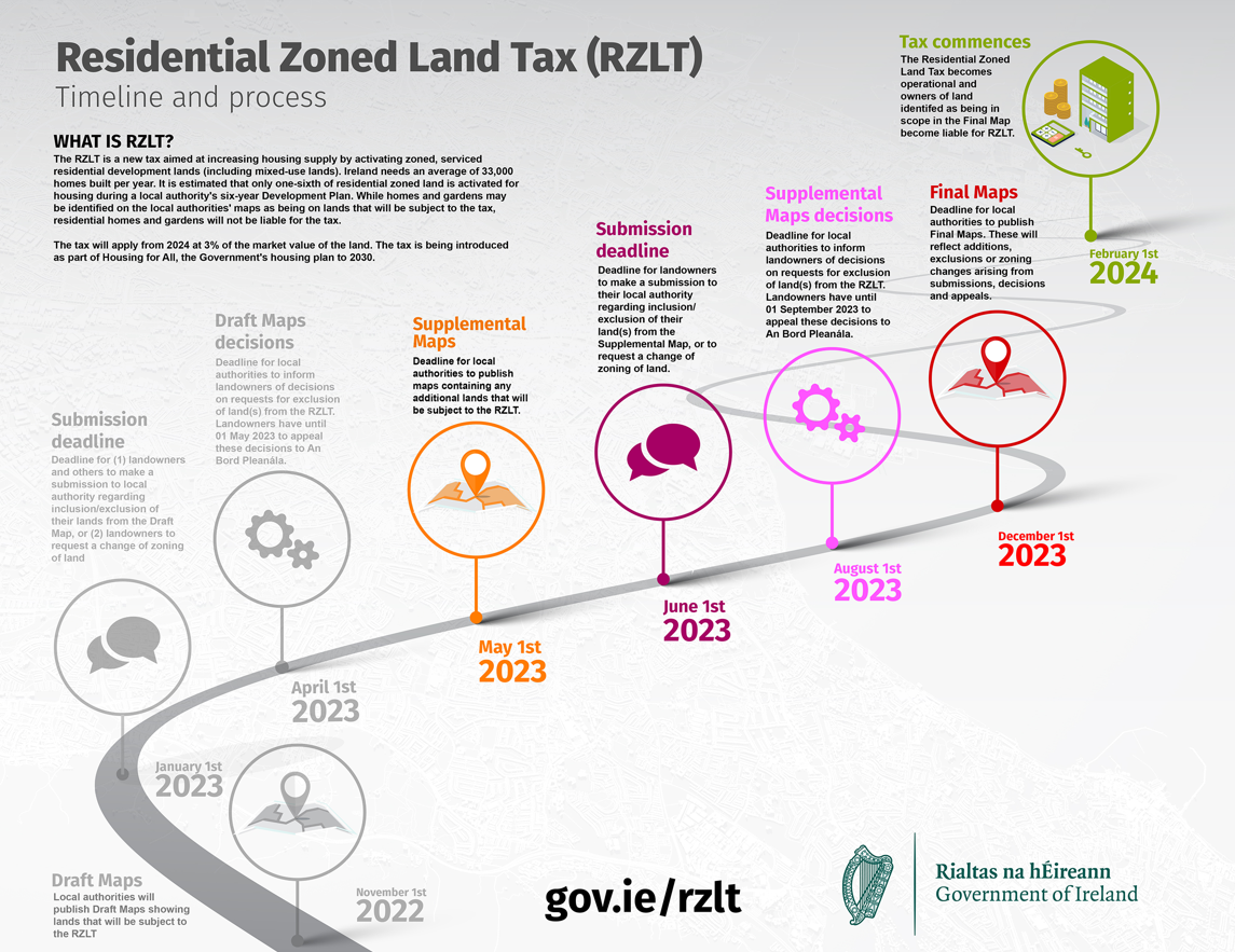
The Rathkeale Local Area Plan was adopted on 10th January 2023 and came into effect on 21st February 2023. A Supplemental Map prepared under Section 653F of the Taxes Consolidation Act 1997, reflecting the zoning of lands under the new Rathkeale Local Area Plan has been published on www.limerick.ie and is available for inspection at its offices (during normal office hours), from 1st of May 2023 to 1st of June 2023 (inclusive):
- Corporate Headquarters, Merchant’s Quay, Limerick,
- County Hall, Dooradoyle, Limerick,
- Rathkeale Office, Áras Seán Finn, New Line, Rathkeale, Co. Limerick,
- Newcastle West Office, Newcastle West, Co. Limerick,
- Kilmallock Office, Áras Mainchín Seoighe, Millmount, Kilmallock, Co. Limerick.
The Supplemental Map has been prepared for the purposes of identifying land that satisfies the relevant criteria and is to be subject to the Residential Zoned Land Tax.
Residential properties, notwithstanding that they may be included on the Supplemental Map, shall not be chargeable to the Residential Zoned Land Tax.
Land which satisfies the relevant criteria is a reference to land that—
- is included in a development plan, in accordance with section 10(2) (a) of the Act of 2000, or local area plan, in accordance with section 19(2)(a) of the Act of 2000, zoned—
(i) solely or primarily for residential use, or
(ii) for a mixture of uses, including residential use,
- it is reasonable to consider may have access, or be connected, to public infrastructure and facilities, including roads and footpaths, public lighting, foul sewer drainage, surface water drainage and water supply, necessary for dwellings to be developed and with sufficient service capacity available for such development, and
- it is reasonable to consider is not affected, in terms of its physical condition, by matters to a sufficient extent to preclude the provision of dwellings, including contamination or the presence of known archaeological or historic remains, but which is not land—
(i) that is referred to in paragraph (a)(i) and, having regard only to development (within the meaning of the Act of 2000) which is not unauthorised development (within the meaning of the Act of 2000), is in use as premises, in which a trade or profession is being carried on, that is liable to commercial rates, that it is reasonable to consider is being used to provide services to residents of adjacent residential areas,
(ii) that is referred to in paragraph (a)(ii), unless it is reasonable to consider that the land is vacant or idle,
(iii) that it is reasonable to consider is required for, or is integral to, occupation by—
(I) social, community or governmental infrastructure and facilities, including
infrastructure and facilities used for the purposes of public administration or the provision of education or healthcare,
(II) transport facilities and infrastructure,
(III) energy infrastructure and facilities,
(IV) telecommunications infrastructure and facilities,
(V) water and wastewater infrastructure and facilities,
(VI) waste management and disposal infrastructure, or
(VII) recreational infrastructure, including sports facilities and playgrounds,
(IV) that is subject to a statutory designation that may preclude development, or
(V) on which the derelict sites levy is payable in accordance with the Derelict Sites Act 1990.
Submissions on the Supplemental Map may be made in writing to the Local Authority
not later than 1 June 2023, regarding—
(I) the exclusion from the final map of specific sites, or
(II) the date on which a site first satisfied the relevant criteria.
Submissions by landowners should include a name and address, reasons for exclusion of lands, along with a map of scale 1:1,000 (urban area) or 1:2,500 (rural area) clearly identifying the area of land subject of the submission.
Any such written submissions received by 1 June 2023 other than such elements of
a submission which may constitute personal data, shall be published on the website
maintained by the Local Authority concerned not later than 11 June 2023.
Where land identified on the Draft Map is included in a development plan or local area plan in accordance with section 10(2)(a) or 19(2)(a) of the Act of 2000 zoned—
(i) solely or primarily for residential use, or
(ii) for a mixture of uses, including residential use,
And where land is identified on the Supplemental Map as being subject to the Residential Zoned Land Tax, a person may, in respect of land that such a person owns, make a submission to the Local Authority requesting a variation of the zoning of that land. Any such submission should include evidence of ownership, detailed reasons for any rezoning request, along with a map to a scale of 1:1,000 (urban) or 1:2,500 (rural) clearly identifying the relevant plot of land. All rezoning requests made will be considered by the Local Authority having regard to the proper planning and sustainable development of the area.
Submissions may be made by close of business on the 1st of June 2023:
- Online at https://mypoint.limerick.ie
- By email to rzlt@limerick.ie or
- In writing to Forward Planning, Economic Development and Enterprise Directorate, Limerick City and County Council, Merchant’s Quay, Limerick
Please make your submission by one medium only, i.e. online, by email or in hard copy.