A chara,
Please find attached the OPR submission on the Draft Abbeyfeale Local Area Plan 2023-2029. Please note that this submission applies to the plan in its entirety.
Kind regards...
Chapter 1: Introduction
Dúnta15 Aib, 2023, 8:00am - 29 Bea, 2023, 5:00pm
The Local Area Plan (LAP) is a statutory document prepared by the Planning Authority, in accordance with the requirements of the Planning and Development Act 2000 (as amended), thereafter referred to as “the Act”. The Abbeyfeale LAP 2014 - 2020 was extended until April 2024 under Section 19 of the Planning and Development Act 2000 (as amended).
This proposed LAP sets out a land use strategy for the proper planning and sustainable development of the town of Abbeyfeale, while complying with the provisions of higher-level spatial plans.
The LAP consists of a written statement and maps indicating objectives for zoning of land, development of residential and economic development and community infrastructure, safeguarding built and natural heritage, and potential opportunities for open space and recreation, active travel and transport, while outlining measures for environmental protection and climate action. The Core Strategy as set out in the Limerick Development Plan 2022 - 2028 sets out the quantum of lands identified for growth in Abbeyfeale, this in turn informs the land use zoning map of this Plan. The written statement generally takes precedence over maps should any discrepancy arise.
The adoption of this LAP is a reserved function of Elected Members of the Municipal District of Newcastle West.
Preparation of this LAP has also been informed by Ministerial Guidelines issued pursuant to Section 28 of the Act, together with EU requirements, regarding Strategic Environmental Assessment (SEA), Appropriate Assessment (AA) and Strategic Flood Risk Assessment.
When interpreting the objectives for the town of Abbeyfeale, it is essential that both the Limerick Development Plan 2022 – 2028 and the Draft LAP are read together.
1.2 Review Process
Given the expiration of the extended lifetime of the existing Abbeyfeale Local Area Plan in 2024, a new LAP is required for the town. Section 20 of the Planning and Development Act 2000 (as amended) sets out the process for the making of a Local Area Plan as outlined in Figure 1 below. The formal process, for the preparation of this Draft Local Area Plan commenced on 22nd October 2022, with the publication of the Issues Paper.
Public consultation is an important aspect of any plan-making process, including the pre-draft stage, in order to identify local issues relating to Abbeyfeale, and to ensure that the final LAP acknowledges community aspirations and concerns. Public consultation during this pre-draft stage, included the publication of an Issues Paper, engagement with St. Mary’s Boys National School and the post-primary school, Coláiste ĺde agus Iosef, a public consultation evening held on the 24th November 2022 in Abbeyfeale and an online social media campaign. The transition year students of Coláiste ĺde agus Iosef also trialled a digital mapping tool, developed by Limerick City and County Council to assist school students to identify issues, which they wanted to be addressed in the Local Area Plan.

Figure 1.1: Students of 4thand 5th Classes Mary’s National School Abbeyfeale identifying issues in Abbeyfeale
During the public consultation period for the pre-draft stage, 17 no. written submissions were received and the students' submitted maps, artwork and numerous digital responses through the mapping tool. The preparation of the Draft Plan has been informed by these submissions and by consultation with relevant stakeholders, service providers, Government Departments and with internal Local Authority departments.
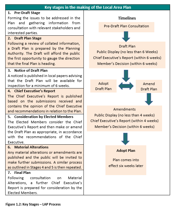
The publication of the Draft will include further public consultation, in line with the requirements of the Planning and Development Act 2000 (as amended). During this time, written submissions will be invited and considered in a Chief Executive’s Report to be issued to the Elected Members of Municipal District of Newcastle West. Subsequent to consideration of the Chief Executive’s Report and its contents, there may be further consultation on Material Alterations, prior to the adoption of the Local Area Plan by the Elected Members. The Planning Authority envisage that the final Plan will be adopted toward the end of 2023.
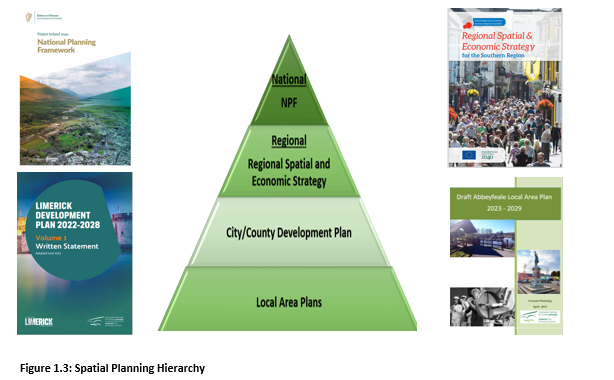
The LAP must be consistent with the objectives of the higher-level spatial plans, including the National Planning Framework (NPF), the Regional Spatial and Economic Strategy for the Southern Region (RSES) and the Limerick Development Plan 2022 – 2028.
Spatial Planning Objective 01:
It is an objective of the Council to ensure that provisions of the Draft Abbeyfeale Local Area Plan 2023 – 2029 for population and economic growth align with the policies and objectives of the higher-level spatial plans, including the National Planning Framework (NPF), the Regional Spatial and Economic Strategy for the Southern Region (RSES) and the Limerick Development Plan 2022-2028.
In accordance with the Planning and Development Act 2000 (as amended), the Draft LAP is subject to the following environmental assessments.
1.4.1 Strategic Environmental Assessment
Strategic Environmental Assessment (SEA) is required in accordance with the SEA Directive (2001/42/EC). SEA is a formal, systematic evaluation of the likely significant environmental effects of implementing a plan, policy or programme. Following a screening exercise, it was determined that a full Strategic Environmental Assessment was required and an SEA Environmental Report accompanies this Draft Plan.
1.4.2 Strategic Flood Risk Assessment
A Strategic Flood Risk Assessment (SFRA) has been prepared in accordance with “The Planning System and Flood Risk Management – Guidelines for Planning Authorities” and Circular PL2/2014 Flooding Guidelines and informs the preparation of the Draft Local Area Plan.
Appropriate Assessment (AA) is required in accordance with Article 6(3) and 6(4) of the EU Habitats Directive (92/43/EEC). AA is a focused and detailed impact assessment of the implications of the plan or project, alone and in combination with other plans and projects, on the integrity of a Natura 2000 site in view of the site’s conservation objectives. Following a screening exercise, it was determined that having regard to, inter alia, the proximity of the Natura 2000 sites to the town of Abbeyfeale, Stage 2 AA is required and to this effect, a Natura Impact Report accompanies this Draft Plan.
The Draft Abbeyfeale LAP covers approximately 215.4 hectares in area and falls within the Abbeyfeale Electoral Division (ED). It contains parts of the townlands of Abbeyfeale East, Abbeyfeale West and Knockbrack. In order to ensure compliance with high-level plans, the settlement boundary for Abbeyfeale is defined by the principle of a compact settlement, prioritising the development potential of the town centre, sequential development from the town centre out and maximising under-used/vacant brownfield infill sites and reuse of existing buildings. This is in line with the NPF requirement whereby 30% of all new homes shall be developed within the built footprint of the town. This built-up footprint relates to the CSO boundary for Abbeyfeale, which is marginally smaller than the settlement boundary of the Draft LAP. (See figure 1.4)
The Census data available for the settlement is a crucial element of plan preparation as it provides the only robust, credible, systematic source of data available to analyse at a local level. This includes population, socio-economic trends and mobility/transport patterns available to support the policies and objectives of the Draft LAP, which are necessary to determine the requirements of the LAP. The 2014 – 2020 (as extended) Abbeyfeale LAP contained 275 ha of zoned lands. The Draft Abbeyfeale LAP is informed by national policy in relation to compact spatial development within all settlements. Consequently, in rationalising the zoning of the town, the settlement boundary has been amended, and the quantum of lands zoned within the Draft LAP has been reduced to 215ha, which results in a reduction of over 22% total quantum of lands zoned in Abbeyfeale.
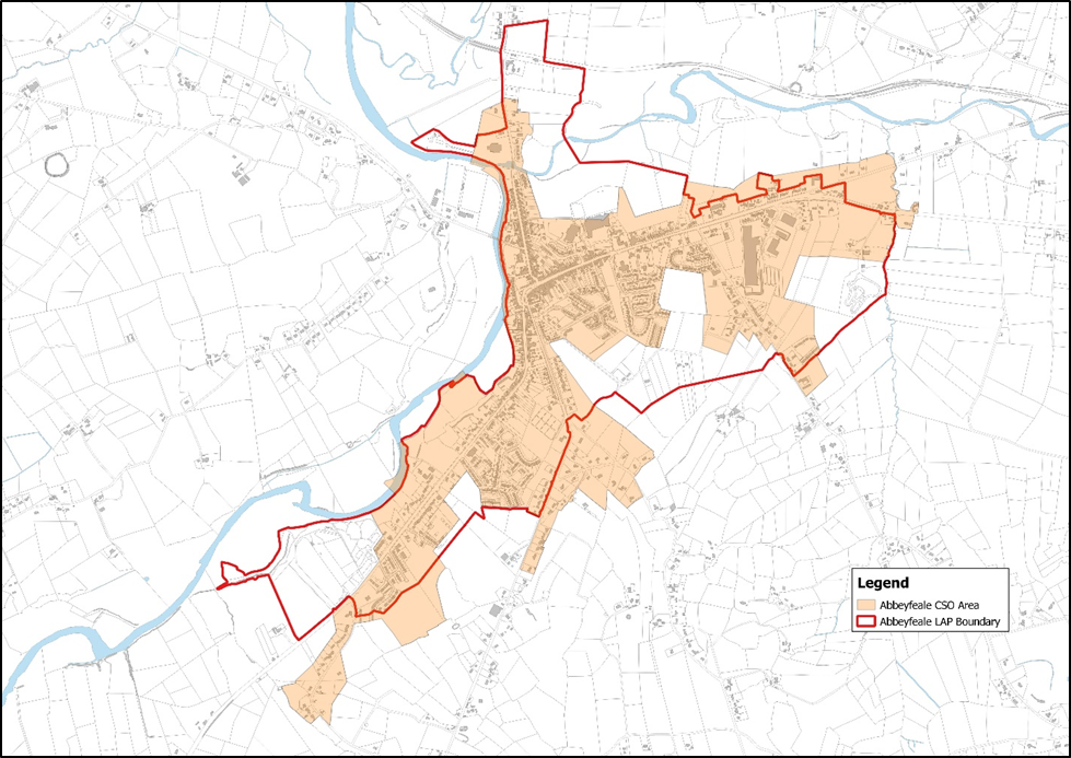
Figure 1.4 Abbeyfeale Census boundary and Draft LAP boundary
Clár ábhair
Tuairimí
Tuairimí
Submission includes specific references to different Chapters or parts of the Draft Plan
Submission includes specific references to different Chapters or parts of the Draft Plan