Chapter 2: Abbeyfeale in Context
Abbeyfeale is located on the Limerick – Kerry border, on the N21 National Route, south of the Mullaghereirk Mountains, approximately 65km south-west of Limerick City and 25km south-west of Newcastle West. The river basins of the River Feale and River Allaughan converge in the town. To the north of town, the topography rises with the slopes of the Mullaghereirks. The N21 Limerick to Tralee national primary route – a key access route in the South West transverses the town centre along Main Street, and the R524 north of Main Street connects Abbeyfeale to Glin on the Shannon Estuary, and Listowel in North Kerry. The urban form of the town has developed in a linear nature extending along the N21 and R524.
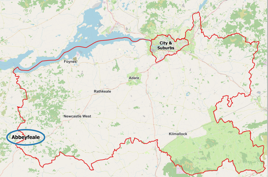
Figure 2.1 – Locational Context of Abbeyfeale
2.2 Settlement Socio-Economic Profile
The principal demographic trends for Abbeyfeale as set out in Census data 2016 are outlined below. This data is significant in terms of determining demand for service provision, such as schools and childcare facilities, housing, health-care, employment opportunities, as well as availability of labour force, standards of education/training attained, deprivation index and disposable income. Some of the key issues identified include; only a marginal increase in population between 2011 and 2016 in Abbeyfeale, an increase in the number of young and older people and a high dependency on the manufacturing sector. Key details are outlined in Figure 2.2 below.
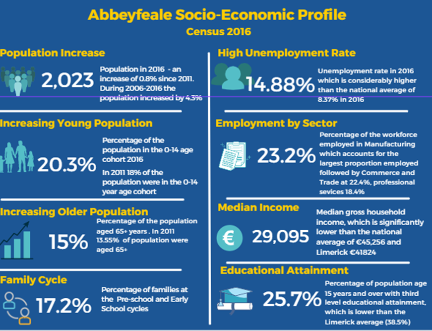
Figure 2.2 – Socio economic profile of Abbeyfeale (Census 2016)
2.3 Historic Settlement Context
Abbeyfeale owes its name to a Cistercian Abbey founded in Abbeyfeale in 1188 and the adjoining River Feale. The Abbey, located north of the present-day town square, founded by Donal O’Brien, King of Limerick, King of Thomond and King of Munster, has since all but disappeared, and the only identifiable remnants are of the Roman Catholic Church built in 1847.
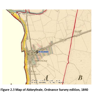
This settlement subsequently developed as an important market town, administrative civic centre and logistics centre for stage coaches and rail transport in the 1800’s in West Limerick. The urban form of the settlement developed in a linear pattern along the present day N21 and the R524, built circa 1787 and 1836 respectively. The railway line opened in 1880 and associated business and trade, such as pubs, a hotel, financial services and agri-business and trades operated in the town serving its agricultural hinterland. This vibrant economy contributed to the unique Stucco architectural detail by Pat McAuliffe found on many of Abbeyfeale’s buildings, in the town centre.
By the 20th century, the town continued to expand, with low density housing on the Hill Road, Clash Road and Killarney Road and businesses, such as the Mart and Kostal locating on the edge of the town. By the mid to late 20th century housing estates developed in the town to accommodate a growing population. The local community developed a substantial community park on the edge of the town on the Killarney Road by the early 21st century. The development of the Limerick Greenway to the north of Abbeyfeale, in recent years offers many opportunities for the town to grow a tourism base, in West Limerick.
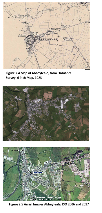
Abbeyfeale has a sprawling linear urban form along its approach roads. The town has retained its 18th and 19th century character with traditional façades and streetscapes. Abbeyfeale continues to perform an important civic, trade/market, healthcare, education and service function for the resident population and for the surrounding hinterlands.
The Limerick Development Plan 2022 – 2028 identifies Abbeyfeale as a Level 3 settlement in the Settlement Hierarchy for Limerick and recognises the importance of Abbeyfeale, having regard to its location on the Limerick – Kerry border, with good quality national and regional road connectivity and the array of high quality services available in the town, which serve its inhabitants and the wider hinterland of Counties Limerick and Kerry.
To fulfil Abbeyfeale’s role as a Level 3 settlement, the town requires consolidation of existing land uses, investment in services, infrastructure, sustainable transport opportunities, amenities and further development of local employment opportunities, which support the existing community in the area, while also providing for additional housing growth and attraction of inward migration.
The map below identifies existing housing schemes currently in Abbeyfeale categorised by those taken in charge by the Local Authority and those not in charge.
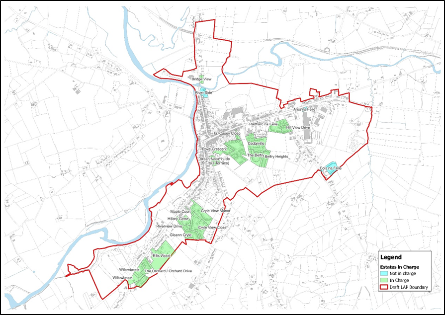 Figure 2.6 Abbeyfeale Housing Schemes
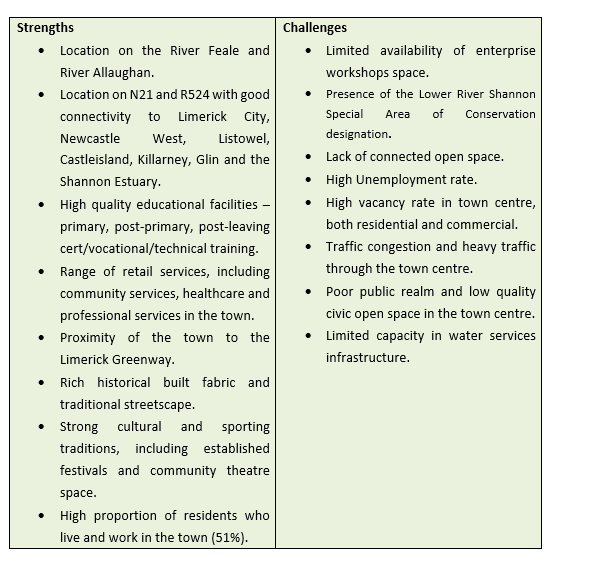
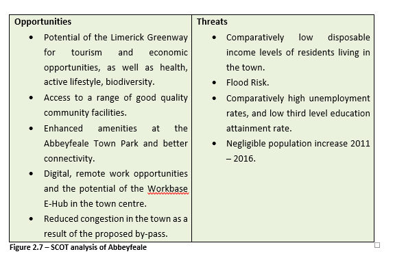
2.4 Strengths/Challenges/Opportunities/Threats
The SCOT Analysis is an analysis of the Strengths, Challenges, Opportunities and Threats that exist within Abbeyfeale. This assessment identifies the key issues in Abbeyfeale and the opportunities that exist to address these issues. The SCOT Analysis has helped inform the overall development strategy for the Plan Area.