Amendments to Environmental Reports
|
Environmental Reports - Material Alterations |
Submission No./ Elected Member Amendment No. |
|
|
1 |
Amend Section 6.3 Stage 1 Flood Risk Identification, item 4 of the table on Page 16 of the Environmental Report as follows:
The CFRAM Maps show flood risk within |
10 |
|
2 |
Amend Section 6.3 Stage 1 Flood Risk Identification, item 4 of the table on Page 16 of the Environmental Report replacing the map of flood extents to include flood zones A and B. |
7 |
|
3 |
Update/Insert flood justification tests 6.5.1 – 6.5.8 to address the extent of flooding in the Proposed LAP boundary as below. |
1, 7 |
6.5 Justification Tests for lands zoned but identified as liable for flooding
As per Section 4.2 of Flood Guidelines, Flood Justification Test has been undertaken for lands zoned in the Proposed LAP, which are identified as liable to flooding, according to the most up to date OPW flooding maps available, under the CFRAM programme and the Stage 1 Assessment above. Eight Justification Tests have been undertaken as and are outlined below. These are: (1) the former Mart, (2) Abbeylands/Ballywilliam, (3) Englishtenements – Cois Deel, (4) Englishtements – New Line Road, (5) Lower Main Street – South of Main Street/R523, (6) Rathkeale Enterprise Park, (7) Enniscouch – Castlematix, south bank of River Deel, and (8) Enniscouch – Chestnut Grove.
6.5.1 Former Mart Site
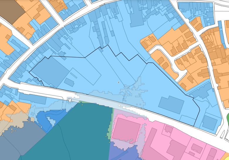
As per Section 4.2 of Flood Guidelines, A Flood Justification Test has been undertaken for lands known as the former Mart Site. These lands are zoned Town Centre in the Proposed LAP. Currently, the lands are under-used with a vacant/derelict structures on site. The location of the site is on the R518 at New Line and adjacent to and south of Main Street Rathkeale. The services of Main Street, the public library, the crèche, Council Municipal District Offices, and the post-primary school are within 150m of this site. The site is serviced. Adjacent land use zones include Existing Residential, Town Centre and the Open Space and recreation. They are zoned Town Centre, Existing Residential Enterprise and Employment to reflect existing use, and Open Space and Recreation. These lands have also been identified as Opportunity Area 1 with potential for small-scale local business, residential and sustainable movement and connectivity in the town centre to improve movement on Main Street and New line to relieve traffic issues in the town centre and on New Line.
|
1
|
The urban settlements for growth under the National Planning Framework, Regional Economic and Spatial Strategy, statutory plans under the Planning and Development Act 2000 as amended, relevant Directives and the Planning Guidelines. |
|
|
Rathkeale is a Level 3 Settlement in the Settlement Hierarchy, identified in the Limerick Development Plan 2022 – 2028. The Limerick Development Plan promotes Level 3 towns as development centers for population growth sustaining a wide range of functions, services and employment opportunities supporting Rathkeale’s hinterland. Rathkeale requires investment in services, infrastructure, transport, employment and housing. In line with National Policy 3c 30% of all new homes targeted within Level 3 settlements shall be within the existing built-up area of the town. The site is located adjacent to Main Street and has potential to support a broad range of employment, retail, community, residential and transport functions for the existing town centre, in addition to critical infrastructure creating a connection between Main Street and New Line, which will support pedestrian and cycle modes and create greater connectivity within the town.
|
||
|
2
|
The zoning or designation of the lands for the particular use or development type is required to achieve the proper planning and sustainable development of the town and in particular: |
|
|
(i) Is essential to facilitate regeneration and/or expansion of the centre of the urban settlement |
This brown-fill site is ideally located in the town centre and is of sufficient scale to offer opportunities, for connectivity between Main Street and community facilities at New Line, including public library, school and crèche. It satisfies national planning policy in terms of compact growth, the re-development of vacant, under-used lands and applying the sequential approach to development by prioritising the development of lands adjacent to the town centre, in this case Main Street in Rathkeale. Appropriate development of these lands supports the envisaged population growth of Rathkeale as per the Core Strategy and higher-level spatial plans within the lifetime of the Proposed LAP. |
|
|
(ii) Comprises significant previously developed and/or under-utilised lands |
This site was the location of the former Mart in Rathkeale Town. This site is vacant and the under-used structures have fallen into dereliction. |
|
|
(iii) Is within or adjoining the core of an established or designated urban settlement |
The lands are zoned town centre and located immediately adjoining the core of the town. A number of key services are within 150m of the site. The site satisfies the 10 Minute Town Concept and redevelopment of the site would support/strengthen the town centre. |
|
|
(iv) Will be essential in achieving compact or sustainable urban growth |
The redevelopment on these lands will contribute to compact urban growth aligned to higher-level spatial policy. |
|
|
(v) There are no suitable alternative lands for the particular use or development type, in areas at lower risk of flooding within or adjoining the core of the urban settlement |
Lands are located on Main Street is the central and historic core of Rathkeale. The lands will assist in consolidation of the core of the town, provide connectivity within the town and support sustainable means of movement. |
|
|
3 |
A flood risk assessment to an appropriate level of detail has been carried out as part of the Strategic Environmental Assessment as part of the local area plan preparation process, which demonstrates that flood risk to the development can be adequately managed and the use or development of the lands will not cause unacceptable adverse impacts elsewhere. |
Part of these lands are subject to flooding as indicated in the map above. The Planning Authority will require applications on these lands to be supported by a comprehensive flood risk assessment as per Flood Guidelines. The Council continue to collaborate with the OPW regarding flood risk in Rathkeale. |
|
4 |
Conclusion of the Justification Test |
|
|
Given the measures above, the objectives of the Proposed LAP, the Planning Authority is satisfied that the proposed zoning of these lands as town centre for development is appropriate subject to more detailed site-specific flood risk assessment to be submitted as supplementary information with planning applications on these lands. |
||
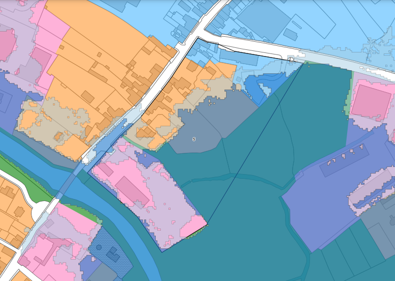
6.5.2 Abbeylands/Ballywilliam
These lands are located on R518 Ballingarry Road, approximately 800m from the town centre and consist of the existing occupied residential units, and lands used primarily for agriculture/grazing.
|
1
|
The urban settlements for growth under the National Planning Framework, Regional Economic and Spatial Strategy, statutory plans under the Planning and Development Act 2000 as amended, relevant Directives and the Planning Guidelines. |
|
|
Rathkeale is a Level 3 Settlement in the Settlement Hierarchy, identified in the Limerick Development Plan 2022 – 2028. The Limerick Development Plan promotes Level 3 towns as secondary development centers for population growth sustaining a wide range of functions, services and employment opportunities which also supports its hinterland. Rathkeale requires investment in services, infrastructure, transport, employment and housing. In line with National Policy 3c 30% of all new homes targeted within Level 3 settlements shall be within the existing built-up area of the town.
|
||
|
2
|
The zoning or designation of the lands for the particular use or development type is required to achieve the proper planning and sustainable development of the town and in particular: |
|
|
(i) Is essential to facilitate regeneration and/or expansion of the centre of the urban settlement |
||
|
(ii) Comprises significant previously developed and/or under-utilised lands |
||
|
(iii) Is within or adjoining the core of an established or designated urban settlement |
No |
|
|
(iv) Will be essential in achieving compact or sustainable urban growth |
No |
|
|
(v) There are no suitable alternative lands for the particular use or development type, in areas at lower risk of flooding within or adjoining the core of the urban settlement |
As per item (i) above |
|
|
3 |
A flood risk assessment to an appropriate level of detail has been carried out as part of the Strategic Environmental Assessment as part of the local area plan preparation process, which demonstrates that flood risk to the development can be adequately managed and the use or development of the lands will not cause unacceptable adverse impacts elsewhere. |
Part of these lands are subject to flooding as indicated in the map above. The Planning Authority will require applications on these lands to be supported by a comprehensive flood risk assessment as per Flood Guidelines. The Council continue to collaborate with the OPW regarding flood risk in Rathkeale. Future development is generally limited to minor developments, where in areas liable to flooding or open space recreation facilities such as walkways. |
|
4 |
Conclusion of the Justification Test |
|
|
Given the measures above, the objectives of the Proposed LAP, the Planning Authority is satisfied that the proposed zoning of these lands as Open Space and Recreation, and Existing Residential for development is appropriate subject to more detailed site-specific flood risk assessments as supplementary information with planning applications on these lands. |
||
6.5.3 Englishtenements – Cois Deel
These lands are located on R518 Ballingarry Road, approximately 700m from the town centre and consist of an occupied housing estate (Cois Deel) zoned Existing Residential, residential development directly served by the R518, zoned existing residential and lands used primarily for agriculture/grazing, zoned Open Space and Recreation.
|
1
|
The urban settlements for growth under the National Planning Framework, Regional Economic and Spatial Strategy, statutory plans under the Planning and Development Act 2000 as amended, relevant Directives and the Planning Guidelines. |
|
|
Rathkeale is a Level 3 Settlement in the Settlement Hierarchy identified in the Limerick Development Plan 2022 – 2028. The Limerick Development Plan promotes Level 3 towns as secondary development centers for population growth sustaining a wide range of functions, services and employment opportunities, which supports its hinterland. Rathkeale requires investment in services, infrastructure, transport, employment and housing. In line with National Policy 3c 30% of all new homes targeted within Level 3 settlements shall be within the existing built-up area of the town.
|
||
|
2
|
The zoning or designation of the lands for the particular use or development type is required to achieve the proper planning and sustainable development of the town and in particular: |
|
|
(i) Is essential to facilitate regeneration and/or expansion of the centre of the urban settlement |
The lands zoned as liable to flooding are zoned Agriculture and Existing Residential. Existing Residential reflects the occupied Cois Deel estate and residential properties on the R518. |
|
|
(ii) Comprises significant previously developed and/or under-utilised lands |
Circa 2.5 hectares of land is zoned Agriculture as this is a less vulnerable use of lands liable to flooding as advised by the Flood Guidelines. |
|
|
(iii) Is within or adjoining the core of an established or designated urban settlement |
The lands are zoned Existing Residential to the north and Agriculture to the south. They are located 300m from town centre and a number of services are in the immediate vicinity of these lands. |
|
|
(iv) Will be essential in achieving compact or sustainable urban growth |
Development is restricted to agricultural use on the lands zoned Agricultural. In the Existing Residential zoned future development is generally limited to minor developments. |
|
|
(v) There are no suitable alternative lands for the particular use or development type, in areas at lower risk of flooding within or adjoining the core of the urban settlement |
Not applicable. The Existing Residential zoning reflects existing use on site. |
|
|
3 |
A flood risk assessment to an appropriate level of detail has been carried out as part of the Strategic Environmental Assessment as part of the local area plan preparation process, which demonstrates that flood risk to the development can be adequately managed and the use or development of the lands will not cause unacceptable adverse impacts elsewhere. |
Part of these lands are subject to flooding as indicated in the map above. The Planning Authority will require applications on these lands to be supported by a comprehensive flood risk assessment as per Flood Guidelines. The Council continue to collaborate with the OPW regarding flood risk in Rathkeale. Future development is generally limited to minor developments, where in areas liable to flooding or open space recreation facilities, such as walkways. |
|
4 |
Conclusion of the Justification Test |
|
|
Given the measures above, the objectives of the Proposed LAP, the Planning Authority is satisfied that the proposed zoning of these lands is appropriate, reflecting the existing uses on site and the measures identified in terms of limiting development on these lands. |
||
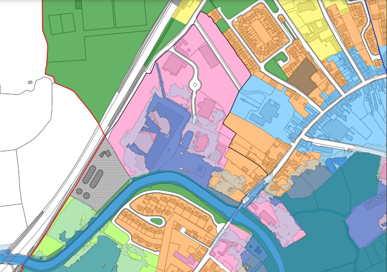
6.5.4 Englishtenements – New Line Road
These lands are located on R518 Ballingarry Road, approximately 700m from the town centre and are zoned Enterprise and Employment, a limited amount of Education and Community and Open Space.
|
1
|
The urban settlements for growth under the National Planning Framework, Regional Economic and Spatial Strategy, statutory plans under the Planning and Development Act 2000 as amended, relevant Directives and the Planning Guidelines. |
|
|
Rathkeale is a Level 3 Settlement in the Settlement Hierarchy identified in the Limerick Development Plan 2022 – 2028. The Limerick Development Plan promotes Level 3 towns as secondary development centers for population growth sustaining a wide range of functions, services and employment opportunities which also supports its hinterland. Rathkeale requires investment in services, infrastructure, transport, employment and housing. In line with National Policy 3c 30% of all new homes targeted within Level 3 settlements shall be within the existing built-up area of the town.
|
||
|
2
|
The zoning or designation of the lands for the particular use or development type is required to achieve the proper planning and sustainable development of the town and in particular: |
|
|
(i) Is essential to facilitate regeneration and/or expansion of the centre of the urban settlement |
Lands zoned Enterprise and Employment and Education and Community Facilities and Open Space reflect existing uses as business, homes and a post-primary school. Similarly, lands zoned Open Space. |
|
|
(ii) Comprises significant previously developed and/or under-utilised lands |
Refer to item (i) above |
|
|
(iii) Is within or adjoining the core of an established or designated urban settlement |
The lands are within 700m of town centre and the zoning reflects existing use as per item (i) above. |
|
|
(iv) Will be essential in achieving compact or sustainable urban growth |
The zoning reflects existing use. |
|
|
(v) There are no suitable alternative lands for the particular use or development type, in areas at lower risk of flooding within or adjoining the core of the urban settlement |
No applicable, significant investment in the area for business, and post-primary school serving a wide hinterland. |
|
|
3 |
A flood risk assessment to an appropriate level of detail has been carried out as part of the Strategic Environmental Assessment as part of the local area plan preparation process, which demonstrates that flood risk to the development can be adequately managed and the use or development of the lands will not cause unacceptable adverse impacts elsewhere. |
Part of these lands are subject to flooding as indicated in the map above. The Planning Authority will require applications on these lands to be supported by a comprehensive flood risk assessment as per Flood Guidelines. The Council continue to collaborate with the OPW regarding flood risk in Rathkeale. Future development is generally limited to minor developments, in areas liable to flooding or open space recreation facilities such as walkways. |
|
4 |
Conclusion of the Justification Test |
|
|
Given the measures above, the objectives of the Proposed LAP, the Planning Authority is satisfied that the proposed zoning of these lands is appropriate, reflecting the existing uses on site and the measures identified in terms of limiting development on these lands. |
||
6.5.5 Lower Main Street – South of Main Street/R523
These lands are located to the rear of the south streetscape of Lower Main Street and New Line. They are zoned Town Centre, Existing Residential Enterprise and Employment to reflect existing use and Open Space and Recreation.
|
1
|
The urban settlements for growth under the National Planning Framework, Regional Economic and Spatial Strategy, statutory plans under the Planning and Development Act 2000 as amended, relevant Directives and the Planning Guidelines. |
|
|
Rathkeale is a Level 3 Settlement in the Settlement Hierarchy identified in the Limerick Development Plan 2022 – 2028. The Limerick Development Plan promotes Level 3 towns as secondary development centers for population growth sustaining a wide range of functions, services and employment opportunities which also supports its hinterland. Rathkeale requires investment in services, infrastructure, transport, employment and housing. In line with National Policy 3c 30% of all new homes targeted within Level 3 settlements shall be within the existing built-up area of the town.
|
||
|
2
|
The zoning or designation of the lands for the particular use or development type is required to achieve the proper planning and sustainable development of the town and in particular: |
|
|
(i) Is essential to facilitate regeneration and/or expansion of the centre of the urban settlement |
These lands are zoned Town Centre, Existing Residential, Enterprise and Employment to reflect existing use, and Open Space and Recreation. They support the central core of the town with residences, and business. |
|
|
(ii) Comprises significant previously developed and/or under-utilised lands |
These land use zones reflect existing use. Land zoned Open Space and Recreation are not in use. |
|
|
(iii) Is within or adjoining the core of an established or designated urban settlement |
Part of these lands area zoned Town Centre. Refer to item (i) above. |
|
|
(iv) Will be essential in achieving compact or sustainable urban growth |
The development on these lands in particular the residential backlands on Lower Main Street will contribute to compact urban growth aligned to higher-level spatial policy. |
|
|
(v) There are no suitable alternative lands for the particular use or development type, in areas at lower risk of flooding within or adjoining the core of the urban settlement |
The land use zones reflect existing use. Refer to item (i) above. |
|
|
3 |
A flood risk assessment to an appropriate level of detail has been carried out as part of the Strategic Environmental Assessment as part of the local area plan preparation process, which demonstrates that flood risk to the development can be adequately managed and the use or development of the lands will not cause unacceptable adverse impacts elsewhere. |
Part of these lands are subject to flooding as indicated in the map above. The Planning Authority will require applications on these lands to be supported by a comprehensive flood risk assessment as per Flood Guidelines. The Council continue to collaborate with the OPW regarding flood risk in Rathkeale. Future development is generally limited to minor developments, in areas liable to flooding or open space recreation facilities such as walkways. |
|
4 |
Conclusion of the Justification Test |
|
|
Given the measures above, the objectives of the Proposed LAP, the Planning Authority is satisfied that the proposed zoning of these lands is appropriate, reflecting the existing uses on site and the measures identified in terms of limiting development on these lands. |
||
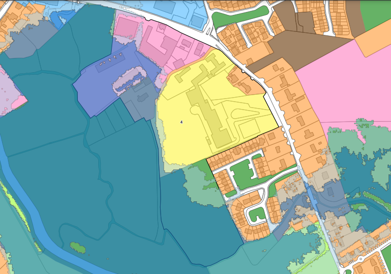
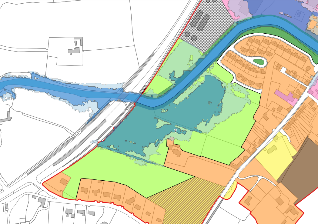
6.5.6 Rathkeale Enterprise Park
These lands are located on the northern bank of the River Deel and east of the N21 and the Limerick Greenway. These lands are zoned Enterprise and Employment reflecting a number of businesses operating in the N21 Rathkeale Business Park. These lands are located circa 400m walking distance of the Town Centre. Lands are also zoned for existing utilities and for agriculture in this area.
|
1
|
The urban settlements for growth under the National Planning Framework, Regional Economic and Spatial Strategy, statutory plans under the Planning and Development Act 2000 as amended, relevant Directives and the Planning Guidelines. |
|
|
Rathkeale is a Level 3 Settlement in the Settlement Hierarchy as identified in the Limerick Development Plan 2022 – 2028. The Limerick Development Plan promotes Level 3 towns as secondary development centers for population growth sustaining a wide range of functions, services and employment opportunities which also supports its hinterland. Rathkeale requires investment in services, infrastructure, transport, employment and housing. In line with National Policy 3c 30% of all new homes targeted within Level 3 settlements shall be within the existing built-up area of the town.
|
||
|
2
|
The zoning or designation of the lands for the particular use or development type is required to achieve the proper planning and sustainable development of the town and in particular: |
|
|
(i) Is essential to facilitate regeneration and/or expansion of the centre of the urban settlement |
This Business Park is critical for the economic sustainability and employment opportunities in Rathkeale and its hinterland. |
|
|
(ii) Comprises significant previously developed and/or under-utilised lands |
At present these lands are near full occupancy for business activity. |
|
|
(iii) Is within or adjoining the core of an established or designated urban settlement |
The business park is within 400m walking distance of the Town Centre and adjacent zoning includes Existing Residential and Town Centre. |
|
|
(iv) Will be essential in achieving compact or sustainable urban growth |
The location is ideal in terms of employment opportunities within walking distance of the Town Centre and supports the 10 Minute Town Concept whereby residential areas are within walking distance of employment opportunities. |
|
|
(v) There are no suitable alternative lands for the particular use or development type, in areas at lower risk of flooding within or adjoining the core of the urban settlement |
The zoning as Enterprise and Employment reflects the established business located in this part of Rathkeale. |
|
|
3 |
A flood risk assessment to an appropriate level of detail has been carried out as part of the Strategic Environmental Assessment as part of the local area plan preparation process, which demonstrates that flood risk to the development can be adequately managed and the use or development of the lands will not cause unacceptable adverse impacts elsewhere. |
Part of these lands are subject to flooding as indicated in the map above. The Planning Authority will require applications on these lands to be supported by a comprehensive flood risk assessment as per Flood Guidelines. The Council continue to collaborate with the OPW regarding flood risk in Rathkeale. Future development is generally limited to minor developments, in areas liable to flooding or open space recreation facilities such as walkways. |
|
4 |
Conclusion of the Justification Test |
|
|
Given the measures above, the objectives of the Proposed LAP, the Planning Authority is satisfied that the proposed zoning of these lands is appropriate, reflecting the existing uses on site and the measures identified in terms of limiting development on these lands. |
||
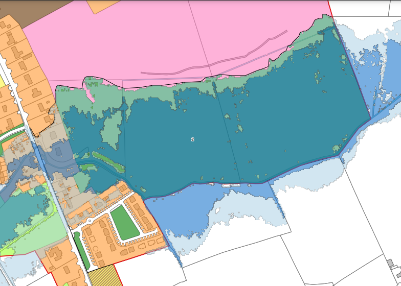
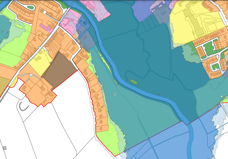
6.5.7 Enniscouch – Castlematix, south bank of River Deel
These lands are located on north of the R523 Old Newcastle West Road, the southern bank of the River Deel, and south the N21. These lands are used primarily for agriculture/grazing and have been zoned Agricultural.
|
1
|
The urban settlements for growth under the National Planning Framework, Regional Economic and Spatial Strategy, statutory plans under the Planning and Development Act 2000 as amended, relevant Directives and the Planning Guidelines. |
|
|
Rathkeale is a Level 3 Settlement in the Settlement Hierarchy identified in the Limerick Development Plan 2022 – 2028. The Limerick Development Plan promotes Level 3 towns as secondary development centers for population growth sustaining a wide range of functions, services and employment opportunities, which also supports its hinterland. Rathkeale requires investment in services, infrastructure, transport, employment and housing. In line with National Policy 3c 30% of all new homes targeted within Level 3 settlements shall be within the existing built-up area of the town.
|
||
|
2
|
The zoning or designation of the lands for the particular use or development type is required to achieve the proper planning and sustainable development of the town and in particular: |
|
|
(i) Is essential to facilitate regeneration and/or expansion of the centre of the urban settlement |
These lands are located on the outskirts of the town. There are sufficient lands zoned as New Residential and Serviced Sites to accommodate the future population growth in accordance with the Core Strategy are more suitable location in the town in terms of serviceability, and sequential location to the town centre. As a less vulnerable use to the flooding agricultural use is deemed most appropriate to these lands |
|
|
(ii) Comprises significant previously developed and/or under-utilised lands |
Not applicable – presently used for grazing. |
|
|
(iii) Is within or adjoining the core of an established or designated urban settlement |
No. There are more appropriate locations for residential, enterprise and employment, community facilities located sequentially to the Town Centre in the interest of compact urban growth as promoted by higher-level spatial policy. |
|
|
(iv) Will be essential in achieving compact or sustainable urban growth |
No. These lands are located on the outskirts of the town. |
|
|
(v) There are no suitable alternative lands for the particular use or development type, in areas at lower risk of flooding within or adjoining the core of the urban settlement |
Agricultural use is considered for appropriate for these lands as a less vulnerable use to flooding as per the Flood Guidelines. |
|
|
3 |
A flood risk assessment to an appropriate level of detail has been carried out as part of the Strategic Environmental Assessment as part of the local area plan preparation process, which demonstrates that flood risk to the development can be adequately managed and the use or development of the lands will not cause unacceptable adverse impacts elsewhere. |
Part of these lands are subject to flooding as indicated in the map above. The Council continue to collaborate with the OPW regarding flood risk in Rathkeale. Development on these lands will be limited to uses associated with Agricultural uses.
|
|
4 |
Conclusion of the Justification Test |
|
|
Given the measures above, the objectives of the Proposed LAP, the Planning Authority is satisfied that the proposed zoning of these lands is appropriate, reflecting the existing uses on site and the measures identified in terms of limiting development on these lands. |
||
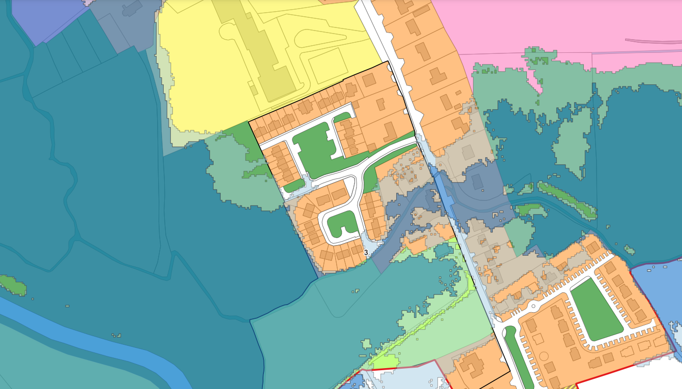
6.5.8 Enniscouch – Chestnut Grove
These lands are located on the eastern western bank of the River Deel. They are zoned Enterprise and Employment, Utilities, Existing Residential and Agriculture reflecting existing land use in this area.
|
1
|
The urban settlements for growth under the National Planning Framework, Regional Economic and Spatial Strategy, statutory plans under the Planning and Development Act 2000 as amended, relevant Directives and the Planning Guidelines. |
|
|
Rathkeale is a Level 3 Settlement in the Settlement Hierarchy as identified in the Limerick Development Plan 2022 – 2028. The Limerick Development Plan promotes Level 3 towns as secondary development centers for population growth sustaining a wide range of functions, services and employment opportunities which also supports its hinterland. Rathkeale requires investment in services, infrastructure, transport, employment and housing. In line with National Policy 3c 30% of all new homes targeted within Level 3 settlements shall be within the existing built-up area of the town.
|
||
|
2
|
The zoning or designation of the lands for the particular use or development type is required to achieve the proper planning and sustainable development of the town and in particular: |
|
|
(i) Is essential to facilitate regeneration and/or expansion of the centre of the urban settlement |
No. The proposed zoning reflects established uses. |
|
|
(ii) Comprises significant previously developed and/or under-utilised lands |
The proposed zoning reflects established uses. |
|
|
(iii) Is within or adjoining the core of an established or designated urban settlement |
These lands are adjacent to Church Street and within walking distance of Lower Main Street and the Town Centre. |
|
|
(iv) Will be essential in achieving compact or sustainable urban growth |
Zoning reflects existing uses. |
|
|
(v) There are no suitable alternative lands for the particular use or development type, in areas at lower risk of flooding within or adjoining the core of the urban settlement |
The proposed zoning is considered appropriate as it reflects existing uses. |
|
|
3 |
A flood risk assessment to an appropriate level of detail has been carried out as part of the Strategic Environmental Assessment as part of the local area plan preparation process, which demonstrates that flood risk to the development can be adequately managed and the use or development of the lands will not cause unacceptable adverse impacts elsewhere. |
Part of these lands are subject to flooding as indicated in the map above. The Planning Authority will require applications on these lands to be supported by a comprehensive flood risk assessment as per Flood Guidelines. The Council continue to collaborate with the OPW regarding flood risk in Rathkeale. Future development is generally limited to minor developments in areas liable to flooding or open space recreation facilities such as walkways. |
|
4 |
Conclusion of the Justification Test |
|
|
Given the measures above, the objectives of the Proposed LAP, the Planning Authority is satisfied that the proposed zoning of these lands is appropriate, reflecting the existing uses on site and the measures identified in terms of limiting development on these lands. |
||
6.6 Conclusion
The precautionary approach has been taken to zoning of lands in Rathkeale, lands identifiable as at risk of flooding in Flood Risk Zone A and Zone B following the Stage 1 Flood Identification Assessment above have been zoned agricultural or open space and recreation and only less vulnerable uses will be open to consideration on these lands, save for the lands justified above, which will be subject to a robust flood risk assessment. Having regard to the approach taken and the objectives set out in the Proposed Local Area Plan, it is considered that the Stage 1 assessment has been carried out in accordance with the relevant standards.