Updated Strategic Environmental Assessment
Table of Contents
1.0 Introduction
2.0 Flood Risk Management Policy
3.0 Flood Risk Identification
3.1 Introduction – Stage 1 Flood Risk Identification
3.2 Flood Risk Indicators
3.3 Conclusion of Stage 1 SFRA
4.0 Stage 2 Strategic Flood Risk Assessment
4.1 Introduction
4.2 Assessment of information outlined above and Delineation of Flood Zones
4.3 Flooding from Other Sources
4.4 Flood Defences
4.5 Flood Risk Zone Mapping
4.6 Climate change considerations
5.0 Recommendations and Integration with Local Area Plan
5.1 Introduction
5.2 Integration of Provisions of Flood Risk Assessment and Flood Management
6.0 Conclusions
Appendix I - Flood Justification Tests
- Introduction
The preparation of the Caherconlish Local Area Plan has been subject to a Strategic Flood Risk Assessment (SFRA), in accordance with The Planning System and Flood Risk Management - Guidelines for Planning Authorities (Department of the Environment, Heritage and Local Government and Office of Public Works, 2009) and Department of the Environment, Community and Local Government Circular PL 2/2014. The SFRA provides an assessment of flood risk and includes mapped extents of Flood Risk Zones. This report considers flood extents to inform the preparation of a land use plan.
The Local Area Plan is a land use plan and provides an overall strategy for the proper planning and sustainable development of the functional area of the village of Caherconlish over the six-year period 2023 – 2029. The principles on which the plan has been developed upon is compact growth, promotion of a self-sustaining settlement supported by sustainable transport, to promote the growth of the village, in an environmentally sustainable manner.
Caherconlish is located approximately 10 kilometers (6 miles) southeast of Limerick City. The village is located just to the south of the main Limerick to Waterford National Primary Road, (N24) providing ease of access to Limerick City, North Cork and the southeast of the County. The village itself is traversed by the R513 linking the village to Hospital, Ballylanders and onto Mitchelstown in North Cork. The village is sited predominantly on the east side of the Groody River, which flows in a south-north direction through the village. The Limerick Development Plan 2022 – 2028 identifies Caherconlish as Level 3 settlement in Limerick. These settlements provide local retail and business services for their surrounding areas. Fig. 1 below shows the location of Caherconlish relative to Limerick City and the Groody River.
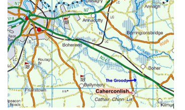
Figure 1: Caherconlish village located on the banks of the Groody River
Flood Risk Management Policy
EU Floods Directive
The European Directive 2007/60/EC provides the overarching European legalisation, in relation to managing flood risk, it seeks to reduce and manage the risks that flooding pose to humans, the environment, cultural heritage and the environment. The legalisation applies to both inland and coastal water sources and requires EU states to:
- Carry out a preliminary assessment in order to identify the river basins and associated coastal areas, where potential significant flood risk exists;
- Prepare flood extent maps for the identified areas;
- Prepare flood risk management plans focused on prevention, protection and preparedness. These plans are to include measures to reduce the probability of flooding and its potential consequences.
Implementation of the EU Floods Directive is required to be coordinated with the requirements of the EU Water Framework Directive and the current National River Basin Management Plan.
National Flood Policy
In line with evolving European legalisation and evolving national legalisation, the government in 2004 established a Flood Policy Review Group and carried out a interdepartmental review of national flood risk management policy and carried out and approved a Flood Policy Review Report. The recommendations of the Report included appointment of the OPW as lead agency for co-ordinating delivery of flood risk management policy. The OPW carries out this role by co-ordinating the implementation of flood risk management policy and measures across three strategic areas:
- Prevention - avoiding construction in flood-prone areas;
- Protection - taking feasible measures to protect areas against flooding.
- Preparedness - planning and responding to reduce the impacts of flood events.
The review also identified a number of key measures for implementation in relation to flood risk management, most relevant to plan preparation is the "Planning System and Flood Risk Management” Guidelines published in 2009, which provide guidance to Local Authorities on plan formulation and decision making in areas at risk of flooding. The review also resulted in an enhancement of the availability of data on flood risk and reporting on flood events, which assists in decision making in relation to land use planning.
2.2.1 National CFRAM Programme
The OPW undertook the National Catchment-based Flood Risk Assessment and Management (CFRAM) Programme in consultation with the Local Authorities and supported by external engineering consultants. The objectives of the CFRAM Programme was to:
- Identify and map the existing and potential future flood hazard and flood risk in the areas at potentially significant risk from flooding, called Areas for Further Assessment (AFAs);
- identify feasible structural and non-structural measures to effectively manage the assessed risk in each of the AFAs, and
- Prepare a set of Flood Risk Management Plans, and associated Strategic Environmental and Habitats Directive (Appropriate) Assessments that set out the proposed feasible measures and actions to manage the flood risk in these areas and their river catchments.
No CFRAM mapping was undertaken for Caherconlish. These maps have recently been updated with the National Indicative Fluvial Mapping and National Coastal Flood Hazard Mapping and probabilistic and historical ground water flood maps prepared by the Geological Survey of Ireland.
2.2.2 Flood Risk Management Guidelines
In 2009, the OPW and the Department of the Environment and Local Government (DEHLG) published Guidelines on flood risk management for Planning Authorities - The Planning System and Flood Risk Management - Guidelines for Planning Authorities. These Guidelines seek to establish a regime to assist with flood risk identification, assessment and management and embed this into the planning process.
The core objectives of the Guidelines are to:
- Avoid inappropriate development in areas at risk of flooding;
- Avoid new developments increasing flood risk elsewhere, including that which may arise from surface water run-off;
- Ensure effective management of residual risks for development permitted in floodplains;
- Avoid unnecessary restriction of national, regional or local economic and social growth;
- Improve the understanding of flood risk among relevant stakeholders; and
- Ensure that the requirements of EU and national law in relation to the natural environment and nature conservation are complied with at all stages of flood risk management.
The Guidelines follow the principle that development should not be permitted in flood risk areas, particularly floodplains, except where there are no alternative and appropriate sites available in lower risk areas that are consistent with the objectives of proper planning and sustainable development.
One of the key areas identified in the Flood Guidelines is around identifying flood risk, which is an expression of the combination of the flood probability or likelihood and the magnitude of the potential consequences of the flood event. It is normally expressed in terms of the following relationship:
Flood risk = Likelihood of flooding x Consequences of flooding
Likelihood of flooding is normally defined as the percentage probability of a flood of a given magnitude or severity occurring or being exceeded in any given year.
Consequences of flooding depend on the hazards associated with the flooding (e.g. depth of water, speed of flow, rate of onset, duration, wave-action effects, water quality) and the vulnerability of people, property and the environment potentially affected by a flood (e.g. the age profile of the population, the type of development and the presence and reliability of mitigation measures).
Flood zones are geographical areas within which the likelihood of flooding is in a particular range and they are a key tool in flood risk management within the planning process as well as in flood warning and emergency planning.
There are three types of flood zones defined for the purposes of the Flood Guidelines:
- Flood Zone A – where the probability of flooding from rivers and the sea is highest (greater than 1% or 1 in 100 for river flooding or 0.5% or 1 in 200 for coastal flooding);
- Flood Zone B – where the probability of flooding from rivers and the sea is moderate (between 0.1% or 1 in 1000 and 1% or 1 in 100 for river flooding and between 0.1% or 1 in 1000 year and 0.5% or 1 in 200 for coastal flooding); and
- Flood Zone C – where the probability of flooding from rivers and the sea is low (less than 0.1% or 1 in 1000 for both river and coastal flooding).
Flood Zone C covers all other areas that are not in zones A or B.
Flood Risk Identification
3.1 Introduction – Stage 1 Flood Risk Identification
Flood risk identification was undertaken in order to identify whether there may be any flooding or surface water management issues within or adjacent to zoned lands and consequently whether Stage 2 SFRA (flood risk assessment) should be proceeded to. Stage 1 SFRA is based on existing information on flood risk indicators based on available flood detail.
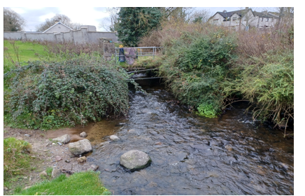
Figure 2: Groody River in the southern part of the plan area.
The Groody is the river that runs through Caherconlish and is at this stage of its development a depositing river, i.e. a river with a shallow gradient flowing through a relatively flat landscape. It is the only water course in the village with the exception of drainage ditches and as such is the main source of any potential flood risk. As part of the review of the Limerick Development Plan, JBA Consultant Engineers carried out an assessment of the existing risk in Caherconlish, no flood modelling has been complete.
While on other locations, CFRAMS provides for project-level development and zoning, the OPW submission dated 25th of November 2022 mentions that there “are few data sets available for Caherconlish”. No CFRAM mapping has been carried out for Caherconlish.
3.2 Flood Risk Indicators
Discussions regarding drainage and flooding issues took place with council engineers, which indicated the location of past flooding events in Caherconlish. Flood info.ie confirmed these locations with reports on hand from the Mulkear Drainage society (1991) and Limerick County Fire Service (2005). The flood maps (Figure 5), have been used as first step, supplemented with site visits and walkovers. It has informed the new zoning extent so that in these areas new zoning is for uses compatible with flood risk, such as agricultural uses.
Figure 3: Taken from Floodinfo.ie, this shows the concentration of Flood events in Caherconlish.
Another possible indication of flooding patterns is that of benefitting lands, i.e. lands that would benefit from flood defence to improve agricultural production.

Figure 4: Benefitting lands shown in light blue in the north east of the plan area. This area is currently zoned agricultural.
3.3 Conclusion of Stage 1 SFRA
The information detailed above indicates elevated levels of flood risk in various locations across the Plan area; therefore, a Stage 2 SFRA has been proceeded to.
4.0 Stage 2 Strategic Flood Risk Assessment
4.1 Introduction
Stage 2 SFRA is being undertaken to:
- Confirm the sources of flooding that may affect zoned and adjacent areas;
- Appraise the adequacy of existing information as identified by the Stage 1 SFRA; and
- Scope the extent of the risk of flooding through the preparation of a Flood Zone Map.
4.2 Assessment of information outlined above and Delineation of Flood Zones
In order to inform the Stage 2 assessment, the village of Caherconlish was inspected, which involved numerous site visits in order to examine, the potential source and direction of flood paths from fluvial sources, locations of topographic features that coincide with the flood boundaries and to identify vegetation associated with a high frequency of flood inundation.
Three factors influence the zoning decisions in relation to these areas. The first is the existence of the flood risk as presented by historic flood reports and discussions with Local Authority personnel, the second is the presence of benefitting lands in the plan area and the third is the JBA flood assessment, carried out in 2021, as part of the review of the Limerick Development Plan. Flood modelling did not take place as the on the on the ground survey supported, both the historic flood reports and the benefitting lands.
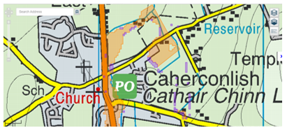
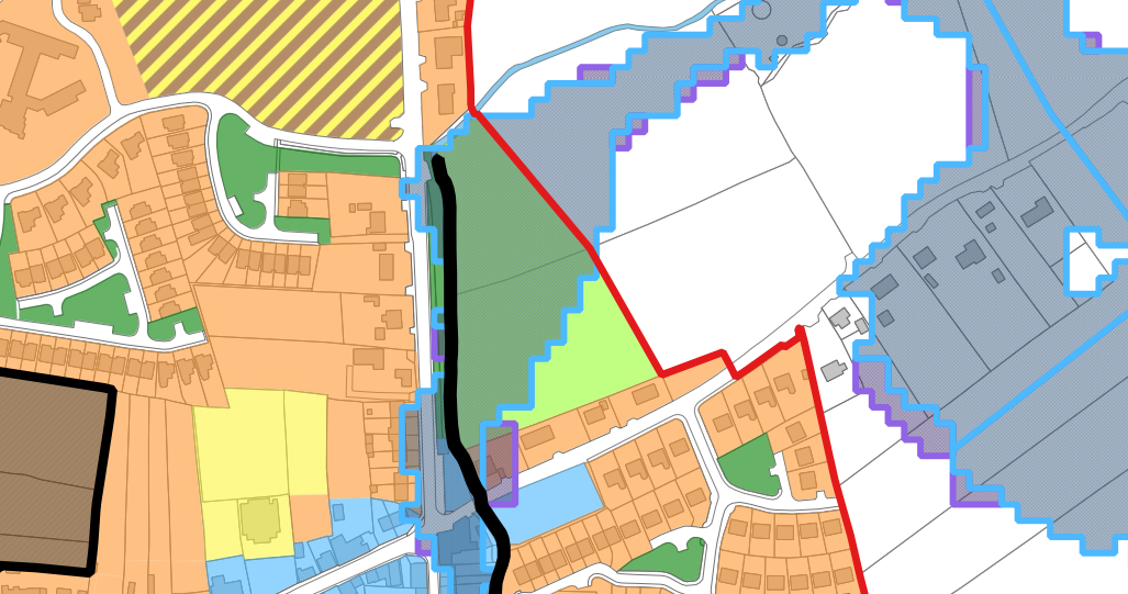
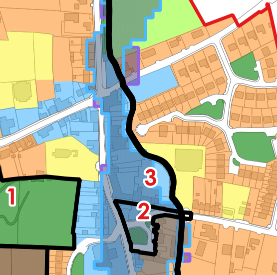
Figure 5: JBA flood mapping indicating Flood Zone A (Orange) and Flood Zone B (purple)
4.3 Flooding from Other Sources
Pluvial flood risk has not featured to great degree in flood risk assessment in Caherconlish. To date such development that has occurred in the village, has not tended to rely on attenuation or nature friendly measures to try and control water flow and run off and local rain fall events can generate considerable volumes of water. The amount of impermeable surfaces and local topography can contribute to local flood events. In the case of Caherconlish, the steep gradient of High Street leading down towards the village centre can cause rainwater to be directed quickly towards the cross roads in the village centre and the area zoned for village centre. The plan does take this issue into account and in Objective IU O4 addresses this issue, in so far as it states that “future developments in flood prone areas are generally limited to minor developments in line with Circular Pl2/2014 and the Flood Risk Management Guidelines for Planning Authorities”.
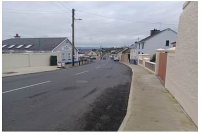
Figure 6: Illustrating the gradient from the top of high street towards the village centre.
Ground water flooding is identified on the Geological Survey of Ireland (GSI) ground water mapping as occurring close to but not in the boundaries of the Local Area Plan.
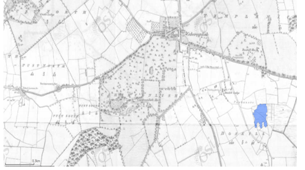
Figure 7: The area shown in blue shows ground water flooding from the GSI website (Historic Ground Water Flood maps, 2015)
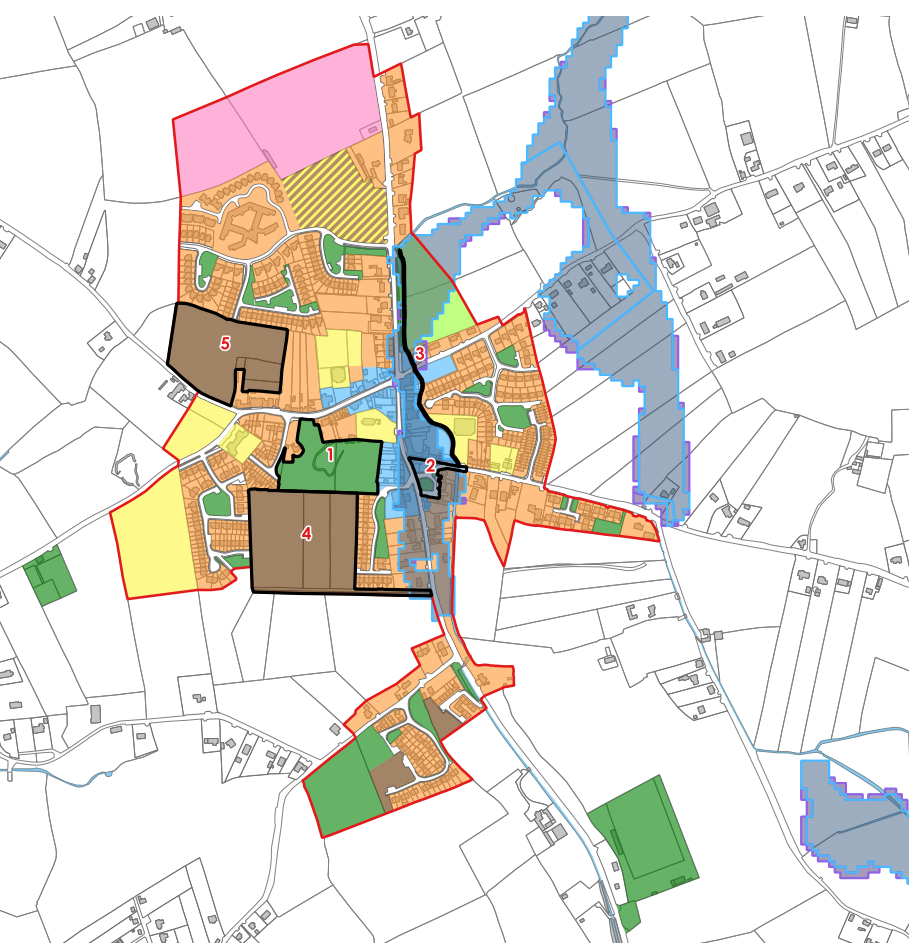
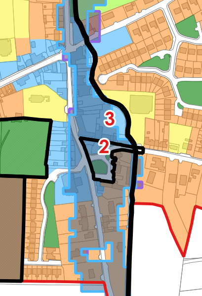
Figure 8: Flood map for Caherconlish, this also shows the groundwater flooding, to the south east, that is on the GSI map in Figure 7.
From the above it can be seen that local changes in development patterns and intensification of land usage can have an effects on overland flow and surface water movement in particular. This can exacerbated when the drainage of channels and storm water routes can be blocked by debris or when the Groody river channel might itself get blocked at a narrow points by debris. There is a narrow point behind the old library building on the southern entrance to the village and there is also the probability of the eyes of the bridges in the village getting blocked by debris.
To reduce the amount of run off in the first instance the insertion of policies which promote nature based solutions and Sustainable Urban Drainage (SuDs) have been included in the plan. This is dealt with further in Section 9.3 of the plan entitled Surface Water Management and SuDS.
4.4 Flood defences
There are no flood defences in Caherconlish.
4.5 Flood Risk Zone Mapping
A Flood Risk Map has been produced taking into account the findings of the Stage 1 and Stage 2 SFRA as detailed above. The map is illustrated below identifies Flood Zone A (darker blue) and Flood Zone B4 (lighter blue). As per the Guidelines, the flood zones in Caherconlish are as follows:
- Flood Zone A – where the probability of flooding from the River Shannon and its tributaries is highest (greater than 1% or 1 in 100 for river flooding);
- Flood Zone B – where the probability of flooding from the River Shannon and its tributaries is moderate (between 0.1% or 1 in 1000 and 1% or 1 in 100 for river flooding); and;
- Flood Zone C – where the probability of flooding from the River Shannon and its tributaries is low (less than 0.1% or 1 in 1000 for river flooding).
 4.6 Climate change considerations
The Planning System and Flood Risk Management Guidelines for Planning Authorities and Technical Appendices, 2009 recommends that a precautionary approach to climate change is adopted due to the level of uncertainty involved in the potential effects. In this regard, the Guidelines recommends:
- Recognising that significant changes in the flood extent may result from an increase in rainfall or tide events and accordingly adopting a cautious approach to zoning land in these potential transitional areas;
- Ensuring that the levels of structures designed to protect against flooding such as flood defences, land raising or raised floor levels are sufficient to cope with the effects of climate change over the lifetime of the development they are designed to protect (normally 85-100 years); and
- Ensuring that structures to protect against flooding and the development protected are capable of adaptation to the effects of climate change when there is more certainty about the effects and still time for such adaptation to be effective
Advice on the expected impacts of climate change and the allowances to be provided for future flood risk management in Ireland is given in the OPW Draft Guidance on Assessment of Potential Future Scenarios for Flood Risk Management (2009). Two climate change scenarios are considered. These are the Mid-Range Future Scenario (MRFS) and the High-End Future Scenario (HEFS). The MRFS is intended to represent a "likely" future scenario based on the wide range of future predictions available. The HEFS represents a more "extreme" future scenario at the upper boundaries of future projections.
In addition to considering climate change factors in the SFRA, the Council have embedded the principles of Sustainable Urban Drainage Systems (SuDS) and Nature Based Solutions (NBS) into the Local Area Plan, which not only has climate benefits, but also a range of environmental benefits to support the delivery of sustainable development. The approach taken in the proposed Local Area Plan, in line with the recently adopted Limerick Development Plan 2022 – 2028, is to seek to adopt SuDS and nature based solutions as appropriate, not just on key development sites. The Council will work with developers to promote SuDS and nature based solutions on a case by case basis and tailor solutions to the specific sites. It is suggested that the following will be placed in the plan; Sustainable Urban Drainage Systems (SuDS) and Nature Based Solutions (NBS): The approach taken in the proposed Local Area Plan, in line with the recently adopted Limerick Development Plan 2022 – 2028, is to seek to adopted SuDS and nature based solutions as appropriate not just on key development sites. The Council will work with developers to promote SuDS and nature based solutions on a case by case basis and tailor solutions to the specific sites. The approach taken in the proposed Local Area Plan, in line with the recently adopted Limerick Development Plan 2022 – 2028, is to seek to adopt SuDS and nature based solutions as appropriate, not just on key development sites. The Council will work with developers to promote SuDs and nature based solutions on a case by case basis and tailor solutions to the specific sites. In draft plan there is a requirement to provide new spaces as part of developments. Though part of standard planning practice, the requirement for minimum open space provision will ensure new permeable surfaces within new developments. Similarly Section 9.3 of the Plan, Surface Water Management and SuDS will ensure the adoption of nature friendly solutions to the issue of surface water management. The contents of the publication Nature-based Solutions to the Management of Rainwater and Surface Water Runoff in Urban Areas Water Sensitive Urban Design Best Practice Interim Guidance Document, will be very useful in this regard.
Section 5 Recommendations and Integration with Local Area Plan
5.1 Introduction
In order to comply with The Planning System and Flood Risk Management - Guidelines for Planning Authorities and Department of the Environment, Community and Local Government Circular (PL 2/2014) and contribute towards flood risk management within the Plan area, the recommendations below have been made by the SFRA process.
- Previously undeveloped lands within Zones A or B should not be zoned for incompatible uses, unless a Justification Test is passed (including a planning conclusion that there are no alternative locations available for accommodating such uses). With respect to previously developed lands, the potential conflict between zonings and highly vulnerable development will be avoided by applying a limiting land use policy approach, as outlined in Objective IU O5 shall be applied on these lands. Full details of all flood justification tests are included in Appendix 1.
- Incorporate policies and objectives to manage surface water in line with Sustainable Urban Drainage Systems and nature based solutions.
As rain fall events are likely to become more frequent this places more importance on elements of surface water management such as SuDS. With this in mind it is considered that all new residential areas zoned in the plan, will from the outset, incorporate nature based approaches to surface water management solutions as part of planning applications. This is already reflected in text in the plan dealing with Opportunity sites in the draft plan. In addition the area zoned for Education and Community and the proposed park area are to remain zoned as such with the proviso that any appropriate development in them maximise the amount of permeable surfaces should paths and play grounds be constructed.
It also considered that the flood benefitting lands located to in the north east part of the land through their agricultural zoning could function as a possible flood residence area. This land is 0.6m below the road level and below the level of existing residential zoned lands to the west. As such it would be useful as spill-over area for possible flooding from the Groody River and would have adequate area to fulfil this function. This would become more important over time as due to climate change, flood events are likely to become more frequent and more severe.
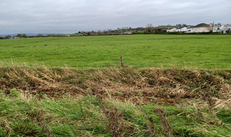
Figure 9: Agricultural lands in the north east of the Plan area.
5.2 Integration of provisions of Flood Risk Assessment and Flood Management into the Local Area Plan
In the formulation of the Local Area Plan to date, the Council have sought to ensure that appropriate integration of the recommendation of the Strategic Flood Risk Assessment for the Draft Caherconlish Local Area Plan has taken place, in order to comply with the Flood Guidelines and the proper planning and sustainable development of the area. Objectives as follows are critical to complying with the relevant legalisation:
- Objective IU O3 – Surface Water Management and SuDS – which relates directly to surface water management and protecting surface water resources
- Objective IU O4 – Flood Risk Management – which seeks to comply with the Flood Guidelines and Circular PL2/2014;
Coupled with key policies and objectives in the Limerick Development Plan 2022 – 2028, which are as follows:
- Policy CAF P5 – Managing Flood Risk - It is a policy of the Council to protect Flood Zone A and Flood Zone B from inappropriate development and direct developments/land uses into the appropriate lands, in accordance with The Planning System and Flood Risk Management Guidelines for Planning Authorities 2009 (or any subsequent document) and the guidance contained in Development Management Standards and the Strategic Flood Risk Assessment (SFRA).
- Objective CAF O20 – Flood Risk Assessments – It is an objective of the Council to require a Site-Specific Flood Risk Assessment (FRA) for all planning applications in Flood Zones A and B and consider all sources of flooding (for example coastal/tidal, fluvial, pluvial or groundwater), where deemed necessary.
- Objective IN O12 – Surface Water and SuDS – The Development Plan sets out that there are many approaches to management of surface water that take account of water quantity (flooding), water quality (pollution), biodiversity (wildlife and plants) and amenity and these are collectively referred to as Sustainable Urban Drainage Systems (SuDS). The use of SuDS to address surface water and its diversion from combined sewers is encouraged, in particular, in infill/brownfield sites and higher density areas as appropriate.
It is considered that the approach outlined above and the policies and objectives of the Limerick Development Plan and the Draft Caherconlish Local Area Plan, provide a robust approach to support the Plan making process.
6.0 Conclusion
Stage 2 SFRA has been undertaken as part of the Plan-preparation process and the SFRA has informed the preparation of the Plan. The SFRA has mapped boundaries identifying areas at risk of flooding, taking into account many factors to determine the extent of flooding. In the preparation of this Local Area Plan, significant rationalisation of the zoning pattern has been carried out, the Council have, in so far as possible sought to avoid zoning of lands at flood risk or have zoned lands for water compatible uses. The Council have also sought to incorporate nature based solutions and blue green infrastructure measures into the plan, as a means of dealing with surface water, while also benefitting climate action.
Appendix I - Flood Justification Tests
As per Section 4.2 of Flood Guidelines, Flood Justification Tests has been undertaken for lands zoned in the Draft LAP, which are identified as liable to flooding, according to the information available for Caherconlish. These lands are in the main are developed or unsuitable for development and where unsuitable for development have been zoned for purpose of agricultural use or Open Space and Recreation, which will generally only permit water compatible uses.
- Lands located in the village core zoned Village Centre
|
1
|
The urban settlements is identified for growth under the National Planning Framework, Regional Economic and Spatial Strategy, statutory plans prepared under the Planning and Development Act 2000 as amended, relevant Directives and the Planning Guidelines. |
|
|
Caherconlish is a Level 3 Settlement in the settlement hierarchy, identified in the Limerick Development Plan 2022 – 2028. The Limerick Development Plan promotes Level 3 settlements, as development centres for population growth sustaining a wide range of functions, services and employment opportunities supporting its hinterland. In line with National Policy Objective 3c, 30% of all new homes targeted within Level 3 settlements shall be within the existing built-up area of the village. Part of the lands within the village centre, are identified as being risk as flooding, however, the lands are also the core of the village and in line with national, regional and local planning policy critical to the overall development of the village centre, will facilitate consolidation and by in large is brown field or infill lands.
|
||
|
2
|
The zoning or designation of the lands for the particular use or development type is required to achieve the proper planning and sustainable development of the town and in particular: |
|
|
(i) Is essential to facilitate regeneration and/or expansion of the centre of the urban settlement |
The lands are proposed to be zoned village centre, reflecting their existing uses. The lands are essential to facilitate regeneration and expansion of the centre of the settlement. |
|
|
(ii) Comprises significant previously developed and/or under-utilised lands |
These lands are already developed and currently occupied by existing uses as per their proposed zoning objective. |
|
|
(iii) Is within or adjoining the core of an established or designated urban settlement |
The lands are zoned village centre and located in the core of the village. |
|
|
(iv) Will be essential in achieving compact or sustainable urban growth |
The redevelopment on these lands will contribute to compact urban growth aligned to higher-level spatial policy. |
|
|
(v) There are no suitable alternative lands for the particular use or development type, in areas at lower risk of flooding within or adjoining the core of the urban settlement |
The lands are currently developed. |
|
|
3 |
A flood risk assessment to an appropriate level of detail has been carried out as part of the Strategic Environmental Assessment as part of the local area plan preparation process, which demonstrates that flood risk to the development can be adequately managed and the use or development of the lands will not cause unacceptable adverse impacts elsewhere. |
The extent of Flood Zone A/B across the village centre zoning follows the line of the Groody River. |
|
4 |
Conclusion of the Justification Test |
|
|
Given the measures above, the objectives of the Draft LAP, the Planning Authority is satisfied that the proposed zoning of these lands as village centre for development is appropriate subject to more detailed site-specific flood risk assessment to be submitted as supplementary information with planning applications on these lands, which may be made in the future. Any developments in these areas are to be limited to developments that are minor in nature and will not result in in increased risk of flooding elsewhere in line with Section 5.28 of the Flood Guidelines and Pl2/2014. |
||
|
|
||
- Existing Residential
|
1
|
The urban settlements is identified for growth under the National Planning Framework, Regional Economic and Spatial Strategy, statutory plans prepared under the Planning and Development Act 2000 as amended, relevant Directives and the Planning Guidelines. |
|
|
Caherconlish is a Level 3 Settlement in the settlement hierarchy, identified in the Limerick Development Plan 2022 – 2028. The Limerick Development Plan promotes Level 3 settlements, as development centres for population growth sustaining a wide range of functions, services and employment opportunities supporting its hinterland. In line with National Policy Objective 3c, 30% of all new homes targeted within Level 3 settlements shall be within the existing built-up area of the village. Part of the lands within the village centre, are identified as being risk as flooding, however, the lands are also the core of the village and in line with national, regional and local planning policy critical to the overall development of the village centre, will facilitate consolidation and by in large is brown field or infill lands.
|
||
|
2
|
The zoning or designation of the lands for the particular use or development type is required to achieve the proper planning and sustainable development of the town and in particular: |
|
|
(i) Is essential to facilitate regeneration and/or expansion of the centre of the urban settlement |
The lands are already developed and the zoning reflects their existing uses. They are a reflection of the historical development of the village, in particular that of the central part of the village. Given the emphasis of the NPF and the RSES on the use of existing development sites, these areas are essential to the viability of the settlement. |
|
|
(ii) Comprises significant previously developed and/or under-utilised lands |
These lands are already developed and currently occupied by existing uses as per their proposed zoning objective. |
|
|
(iii) Is within or adjoining the core of an established or designated urban settlement |
The lands are existing residential and located in the centre of the village. |
|
|
(iv) Will be essential in achieving compact or sustainable urban growth |
The redevelopment and continued use of these lands will contribute to compact urban growth aligned to higher-level spatial policy. |
|
|
(v) There are no suitable alternative lands for the particular use or development type, in areas at lower risk of flooding within or adjoining the core of the urban settlement |
The lands are currently developed. |
|
|
3 |
A flood risk assessment to an appropriate level of detail has been carried out as part of the Strategic Environmental Assessment as part of the local area plan preparation process, which demonstrates that flood risk to the development can be adequately managed and the use or development of the lands will not cause unacceptable adverse impacts elsewhere. |
The extent of Flood Zone A/B across much of this zoning is largely along the route of the Groody River and risks can be managed by limiting development to minor developments in areas at risk of flooding as per Section 5.28 of the Planning and Flood Risk guidelines and Circular PL2/2014. |
|
4 |
Conclusion of the Justification Test |
|
|
Given the measures above, the objectives of the Draft LAP, the Planning Authority is satisfied that the proposed zoning of these lands as existing residential for development is appropriate subject to the provisions of Section 5.28 of the Planning and Flood Risk Guidance and Circular PL2/2014, limiting the extent of development on these lands. |
||
|
1
|
The urban settlements is identified for growth under the National Planning Framework, Regional Economic and Spatial Strategy, statutory plans prepared under the Planning and Development Act 2000 as amended, relevant Directives and the Planning Guidelines. |
|
|
Caherconlish is a Level 3 Settlement in the settlement hierarchy, identified in the Limerick Development Plan 2022 – 2028. The Limerick Development Plan promotes Level 3 settlements, as development centres for population growth sustaining a wide range of functions, services and employment opportunities supporting its hinterland. In line with National Policy Objective 3c, 30% of all new homes targeted within Level 3 settlements shall be within the existing built-up area of the village. For the main part lands zoned, which is at risk of flooding, is zoned for non-vulnerable uses, such as Agricultural and Open Space and Recreation.
|
||
|
2
|
The zoning or designation of the lands for the particular use or development type is required to achieve the proper planning and sustainable development of the town and in particular: |
|
|
(i) Is essential to facilitate regeneration and/or expansion of the centre of the urban settlement |
The lands are proposed to be zoned Agriculture and development will be limited in terms of the uses permitted to water compatible uses. |
|
|
(ii) Comprises significant previously developed and/or under-utilised lands |
Having regard to the location of the lands, only development appropriate to its location would be considered, subject to an appropriate level of assessment. |
|
|
(iii) Is within or adjoining the core of an established or designated urban settlement |
The lands are located within the Plan boundary. |
|
|
(iv) Will be essential in achieving compact or sustainable urban growth |
Only limited development will be considered, subject to an appropriate level of assessment. |
|
|
(v) There are no suitable alternative lands for the particular use or development type, in areas at lower risk of flooding within or adjoining the core of the urban settlement |
Suitable alternative lands are available for vulnerable development elsewhere in areas outside of any flood risk. Agricultural use is considered a less vulnerable use in the Flood Guidelines. |
|
|
3 |
A flood risk assessment to an appropriate level of detail has been carried out as part of the Strategic Environmental Assessment as part of the local area plan preparation process, which demonstrates that flood risk to the development can be adequately managed and the use or development of the lands will not cause unacceptable adverse impacts elsewhere. |
These lands zoned agricultural are at flood risk is nearly entirely within Flood Zone A and B, as identified above. Agricultural use is consider a low vulnerability use, however only water compatible uses will be considered on this land use zoning. |
|
4 |
Conclusion of the Justification Test |
|
|
Part 2 of the Justification Test has not been passed and the site is at risk of flooding, lands will on be considered for water compatible uses in accordance with the Flood Guidelines. |
||