Please see attached the OPR submission on the Draft Caherconlish Local Area Plan 2023-2029. Please note that the attached submission applies to the Plan in its entirety.
Chapter 1 - Introduction
Dúnta15 D.F., 2022, 08:00 - 28 Sam, 2022, 17:00
1.1 What is the Local Area Plan?
The Local Area Plan (LAP) is a statutory document prepared by the Planning Authority, in accordance with the requirements of the Planning and Development Act 2000 (as amended), thereafter referred to as “the Act”. The Caherconlish Local Area Plan 2012-2018 was extended until 2022 under Section 19 of the Planning and Development Act 2000 (as amended). The making of the LAP is a reserved function of Elected Members of the Municipal District of Cappamore-Kilmallock. This Draft LAP sets out a land use strategy for the proper planning and sustainable development of Caherconlish to 2029 whilst complying with the provisions of higher-level spatial plans.
The LAP consists of a written statement and maps indicating objectives for zoning of land, residential development, economic development, community infrastructure, built and natural heritage, open space and recreation, active travel and transport, environmental protection and climate change/adaptation and mitigation. This Draft Plan also includes a Settlement Capacity Audit in which the quantum and location of the land zoned in the Plan, is identified.
The Draft Local Plan has been prepared in accordance with the requirements of the Planning and Development Act 2000 (as amended), higher tier international, national and regional level plans, ministerial guidelines and the Limerick Development Plan 2022-2028. Section 20 of the Planning and Development Act 2000 (as amended) sets out the process for the making of a Local Area Plan as outlined in Figure 1.4 below
Fig. 1.1 Pre-Draft Issues Paper issued February 2022
1.2.1 First Issues Stage
The formal process for the preparation of this Draft Local Area Plan commenced on 6th of February 2022, with the publication of the Issues Paper. This Issues Paper relates to the non-statutory “Pre-Draft” stage of the LAP preparation process as outlined in Figure 1.4. The Issues Paper aimed to encourage interest and debate on the future development of Caherconlish and invited submissions or observations.
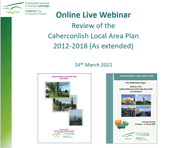
Public consultation during this stage of the process included a schools consultation workshop with students from 1st to 6th Class in Caherconlish National School, an online webinar, a public consultation evening and an online social media campaign.
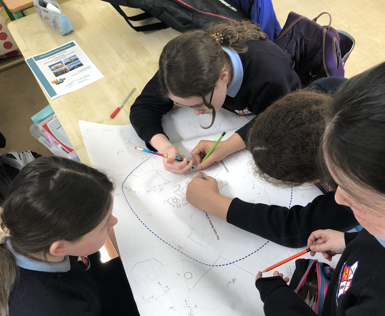
Fig. 1.2 Schools Consultation Workshop
 Fp
Fp
Fig. 1.3 Online Webinar 14th March 2022
1.2.2 Draft Local Area Plan
The publication of the Draft Plan will commence with a public consultation phase on the Draft Local Area Plan, which will take place between the 15th of October and the 28th of November 2022. During this time, written submissions will be invited, which will be considered and summarised in a Chief Executive’s Report which will be issued to the Elected Members of the Municipal District of Cappamore-Kilmallock. There will be an additional consultation period on any Material Alterations following consideration of the Draft Plan by Elected Members. The Planning Authority envisages that the final Plan will be adopted in mid-2023.
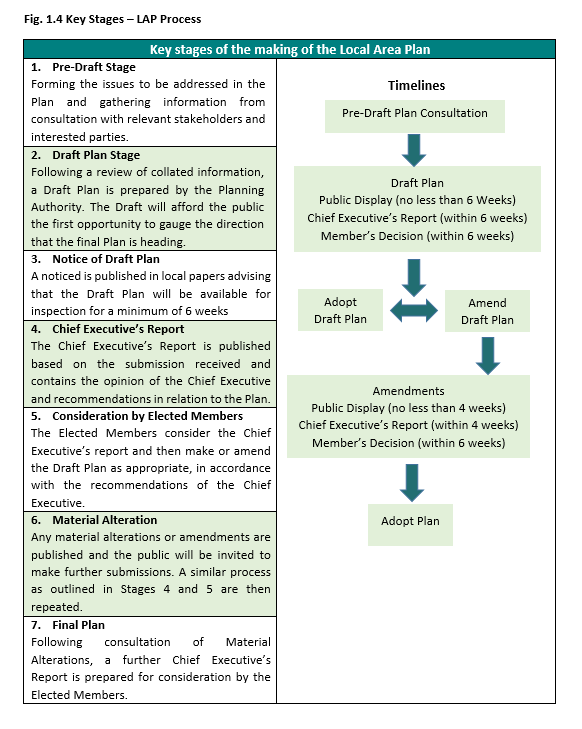
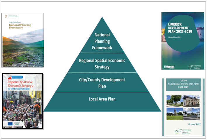
Fig. 5 Spatial Plan Hierarchy
The LAP must be consistent with the objectives of the higher-level spatial plans, including the National Planning Framework (NPF), the Regional Spatial and Economic Strategy for the Southern Region (RSES) and the Limerick Development Plan 2022 – 2028. When interpreting the objectives of the Plan for Caherconlish, it is essential that both the Limerick Development Plan 2022–2028 and the Draft Caherconlish LAP are read together.
Objective I O1: Spatial Planning: It is an objective of the Council to:
Ensure that the population projections and economic growth of the Draft Caherconlish Local Area Plan 2023–2029 align with the policies and objectives of the higher-level spatial plans such as the National Planning Framework (NPF), the Regional Spatial and Economic Strategy for the Southern Region (RSES) and the Limerick Development Plan 2022-2026.
The Draft Caherconlish LAP covers approximately 0.518 square kilometres in area and falls into the Caherconlish West Electoral Division (ED). It contains parts of the townlands of Caherconlish, Hundredacres East, Knockatancashlane, Templemichael, Boskill and Gragane.
The settlement boundary for Caherconlish is defined by the principle of a compact settlement, prioritising the development potential of the village centre, sequential development from the village centre out and maximising under-used/vacant brownfield infill sites and repurposing vacant/derelict existing buildings. The Census CSO data boundary for the village of Caherconlish is more expansive than that of the settlement boundary of the Draft Local Area Plan as outlined in Fig 1.6 below. However, Census Data is a crucial element of the plan as it provides the only robust, credible, systematic source of data available to analyse at a local level. This includes social economic trends and mobility/transport patterns available to support the policies and objectives of the Draft LAP for the sustainable development of the village.
|
Fig. 1.6 Caherconlish CSO Boundary and Draft Local Area Plan Boundary |
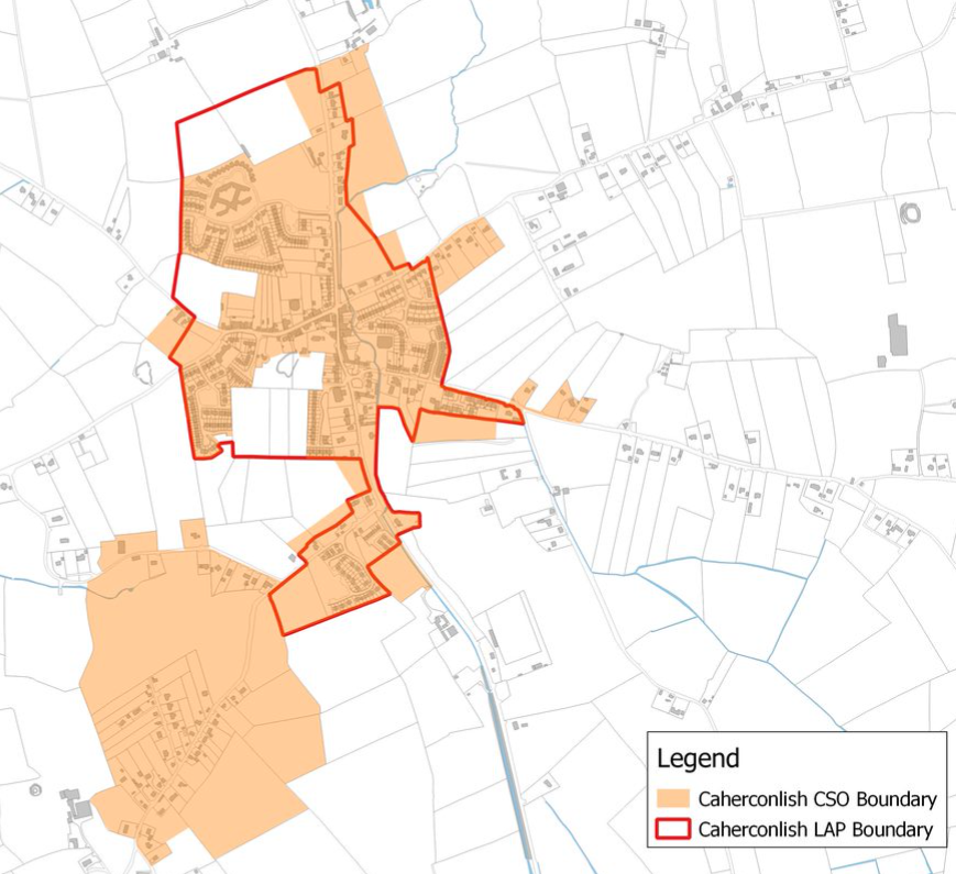
Considering the existing built footprint of the village and to align with national spatial policy, the settlement boundary for the Draft LAP has been determined as per the Draft Land Use Zoning Map in Appendix 1.
1.5.1 Strategic Environmental Assessment and Appropriate Assessment
In accordance with the Planning and Development Act 2000 (as amended), the Draft LAP is subject to the following environmental assessments:
A Strategic Environmental Assessment (SEA) Screening accompanies the Draft LAP in accordance with the SEA Directive (2001/42/EC). This assessment is a formal, systematic evaluation of the likely significant environmental effects of implementing a plan, policy or programme. The conclusion of the SEA screening at this stage of the Draft LAP preparation process is that progression to full SEA and the preparation of an Environmental Report is not required.
Appropriate Assessment (AA) is required in accordance with Article 6(3) and 6(4) of the EU Habitats Directive (92/43/EEC). AA is a focused and detailed impact assessment of the implications of the plan or project, alone and in combination with other plans and projects, on the integrity of a Natura 2000 site in view of the site’s conservation objectives. Following screening for AA, it was determined that the Draft Caherconlish LAP is unlikely to have any impacts on an area designated as a Natura 2000 site, therefore a Natura Impact Report is not required.
As per Section 4.2 of The Planning System and Flood Risk Management - Guidelines for Planning Authorities” as amended by Circular PL2/2014, a Stage 1 Flood Risk Assessment has been prepared and has informed the land use zoning objectives of the Draft LAP.
Clár ábhair
Tuairimí
Tuairimí
Irish Water Submission
Details included in the attachment. Sections of the plan to which the submission refers are noted in the response.
Dear Ms. Burke,
Thank you for your letter of 14 October 2022 regarding the above, the contents of which have been noted.
Transport Infrastructure Ireland...