Covered urban space: It rains a lot in Limerick. The Milk Market canopy has been a huge success and should be used as a template for other parts of the city. Paths or intersections could be covered...
3. Description of Proposed Works
Dúnta26 Iúil, 2019, 12:00 - 6 M.F., 2019, 23:59
The proposed works provide for the redistribution of space on O’Connell Street from Denmark Street to Cecil Street, between various modes of transport and the public realm.
There are currently two southbound traffic lanes on O’Connell Street between Denmark Street and Cecil Street. Kerbside activities are provided for along both sides of the street, including parking, disabled parking, taxi ranks, loading bays and bus stops. General parking occupies the majority of this space along the full length of the street.
Phase 1 of the O’Connell Street Revitalisation project will reduce the width of traffic lanes between Denmark Street and Cecil Street to a maximum of 3.0m, and relocate parking and other kerbside vehicular spaces. This space will be adapted to provide wider footpaths, a southbound bus lane between William Street and Cecil Street, and additional public realm areas to facilitate people gathering, on-street trading, “spill out zones” from shops and cafes on the street to allow e.g. tables and chairs or promotional events, all of which will contribute to the sense of place and make O'Connell Street a destination in and of itself as well as a transport link in the city centre.
Street furniture including seating areas, trees, planting, bicycle stands, and lighting will be provided, as well as features such as sculptures, pedestrian plazas and water installations.
The reduction in space dedicated to vehicular traffic will be strengthened by the reconfiguration of the carriageway to provide one vehicular lane and one bus lane along O’Connell Street from William Street to Cecil Street. A shared surface, where the footpath and the carriageway will be at the same level, will be introduced on O’Connell Street just north of Denmark Street and will continue for three blocks to just south of Roches Street. This will introduce a Universal Design concept by improving the ease and comfort of pedestrian movement on the street whilst reducing the perceived priority and dominance of motor vehicles. A shared surface is also proposed outside the proposed International Rugby Experience museum just north of Cecil Street. As a result, all junctions within the proposed development boundary will be converted to raised table junctions, which will act as traffic calming measures, especially for traffic on the side streets off O’Connell Street, which will be required to ramp up and down to cross the street also.
The 6m-wide corridor proposed for use by vehicular traffic has been designed so as to provide for flexible uses in the future. It is anticipated that this will remain a movement corridor; however the form of this may change over time. For example, it will accommodate with minimal amendments a two-way dedicated public transport corridor with segregated cycleways if required under the Limerick Metropolitan Area Transport Strategy.
The proposals for each block are described in more detail in Sections 3.1 to 3.3 below.
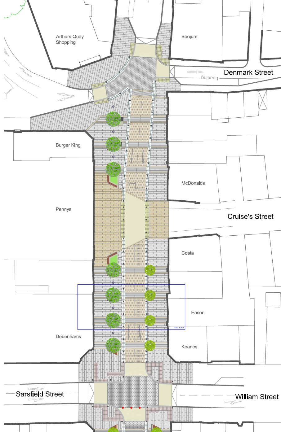
3.1 Denmark Street to William Street
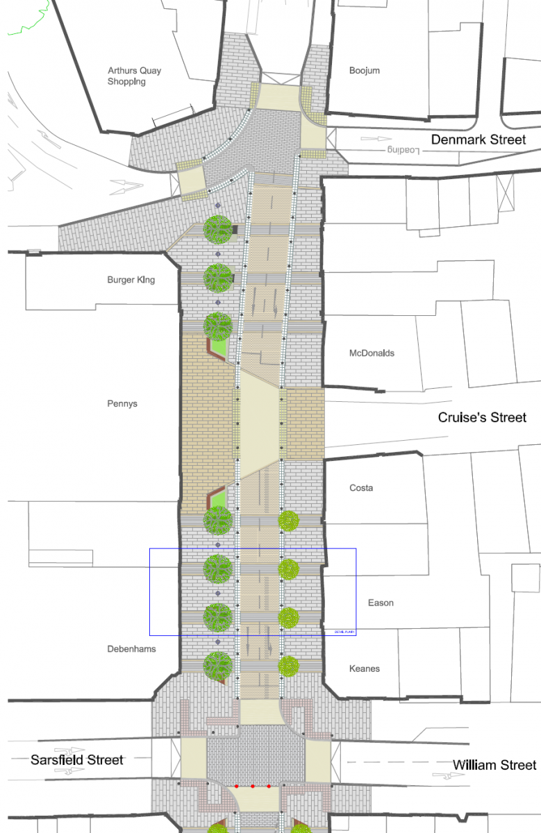
Figure 1: Proposed Design - Denmark Street to William Street
O’Connell Street will be converted to a shared surface between Denmark Street and William Street, with a combination of street furniture, tactile paving and bollards rather than kerbs to delineate the pedestrian space. Two lanes of general traffic will remain on this section of O’Connell Street.
A total of 14 trees will be planted on this block, with seven large trees planted directly at street level on the western side of the street, and seven slightly smaller trees in raised planters on the eastern side. Seating, other lower-level planting, and bicycle parking areas will be provided between the trees. These will provide rest areas and meeting points for pedestrians and cyclists, as well as acting as delineators between the carriageway and pedestrian area. The presence of trees and planting will also soften the hard landscaping on the street and introduce a natural element in the built environment. A plaza area on the western side of this block, directly opposite Cruise’s Street, creates a sense of place at the northern end of O'Connell Street and reduces the focus on through movements.
The junctions at Denmark Street and William Street will be raised level with the footpaths, and therefore traffic to and from Patrick Street, Denmark Street, Arthur’s Quay, Sarsfield Street and William Street will ramp up and down at these junctions. An uncontrolled pedestrian crossing will be provided at the western end of Cruise’s Street to cater for the pedestrian desire line across O'Connell Street at this location. This crossing will be ducted to allow for a future installation of signals should they be deemed necessary. Traffic signals will be retained at the William Street junction. A new bus stop will also be provided on Patrick Street, to the north of Denmark Street, in order to provide sufficient services to the city centre with the relocation of the existing stop outside the Augustinian Church further south.
Currently, no parking or other kerbside activities are permitted, and this arrangement is proposed to continue.
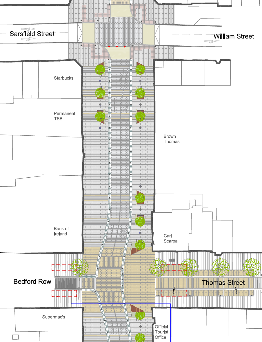
3.2 William Street to Roches Street

Figure 2: Proposed Design - William Street to Thomas Street
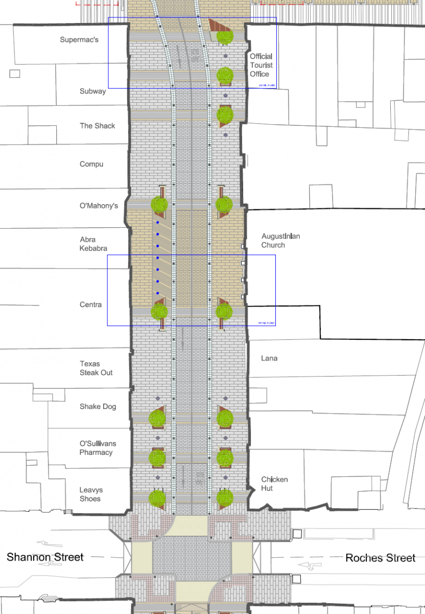
Figure 3: Proposed Design - Thomas Street to Roches Street
The proposed shared surface will continue from William Street to Roches Street. A combination of street furniture, tactile paving, bollards and short runs of guard rail will again be used instead of kerbs to delineate the pedestrian space. Two southbound vehicular lanes will be provided, with the left-hand lane dedicated as a bus lane, catering for buses, cyclists, and other public transport vehicles such as taxis, while the right-hand lane will remain as a general vehicular lane.
A total of 18 trees will be planted on these two blocks, with six at either end in a mirrored arrangement of three on each side. These will “bookend” the two central blocks on O’Connell Street which form the core retail centre of the city and the key pedestrian priority area. A further six trees will be located on the eastern side of the street on the approaches to Thomas Street. Seating, other lower-level planting, and bicycle parking areas will be provided between the trees in a similar arrangement to the Denmark Street – William Street block, providing continuity along the street. Areas of planting and street furniture will again act as delineators between the pedestrian area and proposed carriageway, as well as providing rest areas and meeting points for pedestrians and cyclists and alerting motorists to a change in layout at the junctions. The presence of trees will also soften the hard landscaping on the street and introduce a natural element in the built environment.
A horizontal deflection will be introduced in the vehicular route at the junction of O'Connell Street, Thomas Street and Bedford Row. The carriageway will deflect towards Bedford Row at the junction and revert to the centre of O'Connell Street to the south of the junction. Access will be maintained from Bedford Row, while access from Thomas Street will be closed permanently to vehicular traffic. This alignment provides flexibility for future alterations to the street should further public transport priority be deemed appropriate, or indeed further pedestrian priority among other options. The horizontal change in vehicle movement will provide a larger pedestrian plaza area extending and merging into Thomas Street, as well as creating a traffic calming measure to reduce vehicular speeds in this pedestrian-priority area. The central space in this plaza has the potential to accommodate the future installation of public artwork to generate a further focal point for pedestrian gathering. An interactive surface-level water feature will also be installed opposite the Augustinian Church (outlined in bold in Figure 3 above).
Traffic travelling from Sarsfield Street to William Street (eastbound) and from Roches Street to Shannon Street (westbound) will ramp up and down at the junction with O'Connell Street. No parking or other kerbside activities will be permitted. Existing disabled parking bays, loading bays, taxi ranks etc. will be relocated to nearby side streets. The existing bus stop outside the Augustinian Church will be relocated to south of Roches Street.
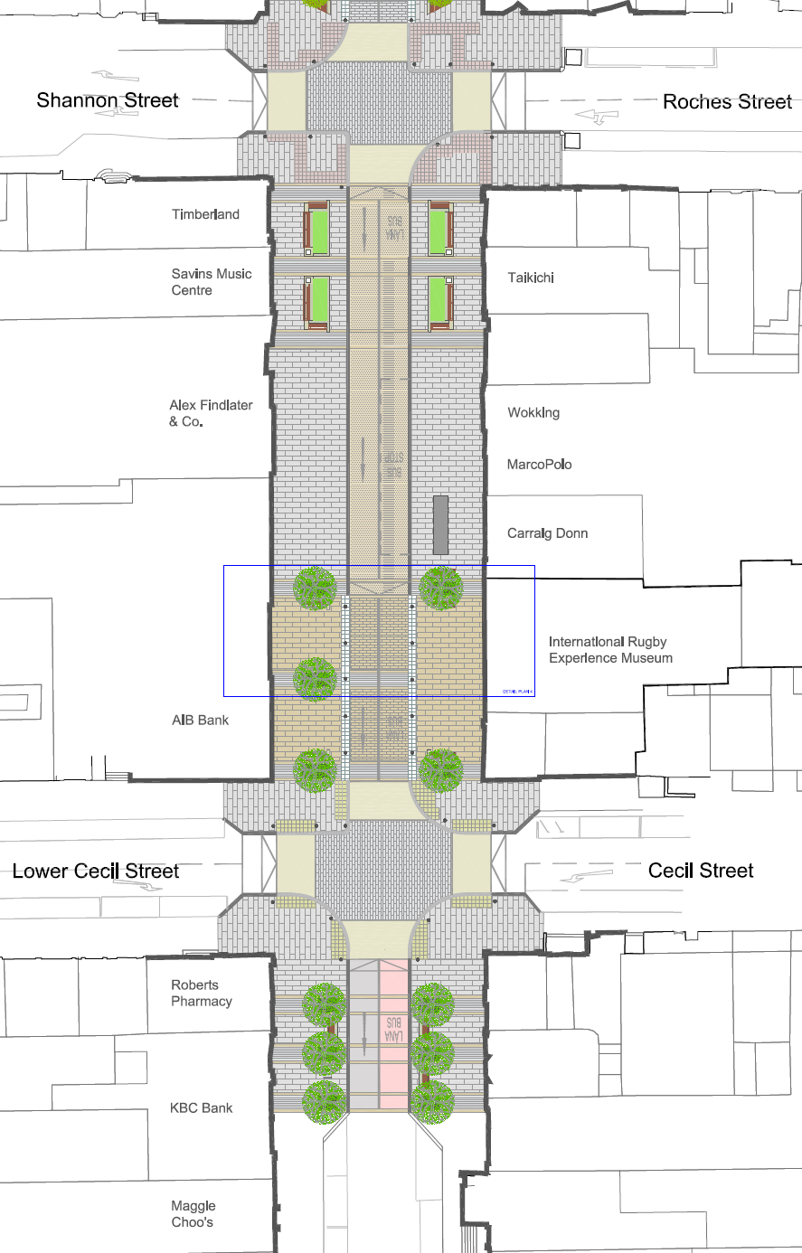
3.3 Roches Street to Cecil Street
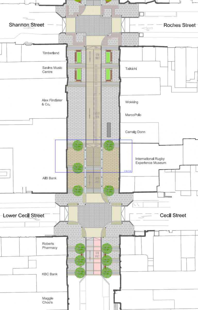
Figure 4: Proposed Design - Roches Street to Cecil Street
From Roches Street to Cecil Street and to the immediate south of the junction with Cecil Street, the arrangement of two vehicular lanes travelling from north to south will continue with a bus lane on the left and a general vehicular lane on the right. Southbound traffic will ramp down from the raised junction with Roches Street and there will be a level difference between the footpath and the carriageway on the northern section of this block. The carriageway here will be surfaced in asphalt to denote the non-shared nature of this section of the street. An in-lane bus stop will be provided in this section. No parking or other kerbside activities will be permitted. Existing disabled parking bays, loading bays, taxi ranks etc. will be relocated to nearby side streets.
A total of 11 trees will be planted on this block, around the junction of O'Connell Street and Cecil Street. These will act as a boundary to Phase 1 of the scheme, similar to the arrangements at the William Street and Roches Street junctions. Six trees will be planted on the southern side of the junction in a mirrored arrangement of three on each side. Five trees will be planted on the northern side in a similar arrangement, with three trees on the western side and two on the eastern side in order to frame the façade of the proposed International Rugby Experience. Seating, other lower-level planting, and bicycle parking areas will be provided between the trees on the western side. These will again act as delineators between the carriageway and pedestrian area, as well as providing rest areas and meeting points for pedestrians and cyclists and alerting motorists to a change in layout at the junctions. The presence of trees will also soften the hard landscaping on the street and introduce a natural element in the built environment.
An extended raised table junction at Cecil Street, similar to the shared surface areas further north, will act as a traffic calming measure and provide a sense of place at the proposed International Rugby Experience museum, which will occupy the corner of O'Connell Street and Cecil Street (outlined in bold in Figure 4 above).
Clár ábhair
Ábhair
Tuairimí
Tuairimí
Lack of Pedistrianisation & Cycle Lanes
From Castletroy, I mainly travel to the city centre by car when I need to. With better public transport access and safer cycle access I would be better able and more often willing to travel to the...
2. Observation 2 - Continued facilitation of through traffic in the form of dual-lane one-directional roads without conta-flow access for bike users
2. Observation 2 - Continued facilitation of through traffic in the form of dual-lane one-directional roads without conta-flow access for bike users
The ‘Limerick Metropolitan Cycle Network Study...
3 Observation 3 - Unnecessary amount bollards that will cause a risk to cyclists
It is noted that there are 188 bollards on the proposed design. While these bollards are in no doubt an attempt to deal with the high level of illegal parking that currently is facilitated in...
4. Failure of proposed plans to fulfil the visions and objectives set out in the brief
To Conclude
We passionately support the listed objectives of the project and we commend the local authority and the design team for identifying those objectives.
2.1 Vision and Objectives...