Submission attached
Chapter 10: Land Use Framework, Zoning Matrix and Settlement Capacity Audit
Closed15 Apr, 2023, 08:00 - 29 May, 2023, 17:00
10.1 Land Use Zoning and Implementation
This Local Area Plan outlines specific policies and objectives for the development of Abbeyfeale. The overarching policies and objectives of the Limerick Development Plan 2022 - 2028 and any replacement thereof also apply. All development requiring planning permission must adhere to the Policies, Objectives, Development Management Standards and other requirements of the Limerick Development Plan 2022 - 2028, or any replacement thereof.
The purpose of zoning is to indicate to property owners and the public the types of development, which the Planning Authority considers most appropriate in each land use category. Zoning is designed to reduce conflicting uses within areas, to protect resources and ensure that land suitable for development is used in the interest of sustainable settlements. The Land Use Zoning Map should be read in conjunction with the Land Use Zoning Objectives below, and the Land Use Zoning Matrix set out under Appendix I.
|
Land Use Zone |
2023 Area - ha |
2014 Area - ha |
|
Agriculture |
41.14 |
62.29 |
|
Education and Community |
12.59 |
10.24 |
|
Enterprise and Employment |
37.00 |
36.86 |
|
Existing Residential |
52.81 |
51.25 |
|
Local Centre |
1.72 |
7.39 |
|
Open Space and Recreation |
33.50 |
37.25 |
|
Residential Serviced Sites |
3.03 |
16.32 |
|
Tourist Related Development |
1.52 |
1.14 |
|
Town Centre |
12.19 |
9.12 |
|
Utilities |
2.15 |
3.53 |
|
New Residential |
8.86 |
24.92 |
|
Semi-natural Open Space |
9.00 |
7.81 |
|
Total |
215.48 |
275.09 |
Table 8: Quantum of lands zoned per land use zone 2014 and 2023
|
Land Use Zoning |
Objective and Purpose |
|
Town Centre |
Objective: To protect, consolidate and facilitate the development of Abbeyfeale’s commercial, retail, educational, leisure, residential, social and community uses and facilities. Purpose: To consolidate Abbeyfeale’s Town Centre through densification of appropriate commercial and residential developments ensuring a mix of commercial, recreational, civic, cultural, leisure, residential uses and urban streets, while delivering a high-quality urban environment, which will enhance the quality of life of residents, visitors and workers alike. This zone will strengthen retail provision, in accordance with Retail Strategy for Limerick – Shannon Metropolitan Area and County Limerick 2022 –2028, emphasise urban conservation, ensure priority for public transport, pedestrians and cyclists, while minimising the impact of private car-based traffic and enhancing the existing urban fabric. |
|
Local Centre |
Objective: To protect and provide local centre facilities to serve the needs of new/existing neighbourhoods and residential areas. Purpose: To provide a mix of community and commercial neighbourhood facilities to primarily serve the immediate needs of the local working and residential population and complement, rather than compete with the Town Centre. A mix of appropriate convenience retail, commercial, community, childcare and medical facilities, residential and recreational development of a local scale will be considered. The retail scale and type will be controlled to prevent negative impacts on the retail function of Abbeyfeale Town Centre. Any proposal for retail development shall comply with the Retail Strategy for the Limerick Shannon Metropolitan Area and County Limerick 2022 -2028. |
|
Existing Residential
|
Objective: To provide for residential development, protect and improve existing residential amenity. Purpose: This zoning reflects established housing areas. Existing residential amenity will be protected while allowing appropriate infill development. The quality of the area will be enhanced with associated open space, community uses and where an acceptable standard of amenity can be maintained, a limited range of other uses that support the overall residential function of the area, such as schools, crèches, doctor’s surgeries, playing fields etc. |
|
New Residential
|
Objective: To provide for new residential development in tandem with the provision of social and physical infrastructure. Purpose: This zone is intended primarily for new high quality housing development. The quality and mix of residential areas and the servicing of lands will be a priority to support balanced communities. New housing and infill developments should include a mix of housing types, sizes and tenures, to cater for all members of society. Design should be complimentary to the surroundings and should not adversely impact on the amenity of adjoining residents. These areas require high levels of accessibility, including pedestrian, cyclists and public transport (where feasible). This zone may include a range of other uses particularly those that have the potential to facilitate the development of new residential communities such as open space, schools, childcare facilities, doctor’s surgeries and playing fields etc. |
|
Residential Serviced Sites |
Objective: To offer an alternative to the rural one off house, providing an opportunity for people to design a house to their individual needs and supported by existing services. Purpose: Provides opportunities for those seeking to design and build their own home on serviced lands within the town, including water services, road, footpaths and lighting and within walking distance of the town centre. Each individual plot shall not exceed 0.1ha and the overall density of the scheme shall be 10 units per hectare. |
|
Education and Community
|
Objective: To protect and provide for educational, training and adult learning, community, healthcare, childcare, civic, religious and social infrastructure. Purpose: To protect existing and allow for expansion of a wide range of educational facilities, services and related development. To facilitate sustainable development of community infrastructure and create an inclusive high quality of life. This land use will provide for community facilities, healthcare services, childcare, religious, social and civic infrastructure, ancillary purpose-built accommodation, such as residential care or institutions to support the main use only, and other facilities. |
|
Enterprise and Employment
|
Objective: To provide for and improve general enterprise, employment, business and commercial activities. Purpose: Provides for enterprise, employment and general business activities and acknowledge existing/permitted retail uses. This land use zone may accommodate light industry, low input and emission manufacturing, logistics and warehousing and office developments. The form and scale of development on these sites shall be appropriate to their location, having regard to surrounding uses and scale. A proliferation of retail uses will not be permitted. Proposals may generate a considerable amount of traffic by both employees and service vehicles and traffic assessments may be required. Sites should be highly accessible, well designed and permeable with good pedestrian, cyclist links to the town centre and public transport. The implementation of mobility management plans will be required to provide important means of managing accessibility to these sites. |
|
Open Space and Recreation
|
Objective: To protect, provide for and improve open space, active and passive recreational amenities. Purpose: To provide for active and passive recreational resources including parks, sports and leisure facilities and amenities. The Council will not normally permit development that would result in a substantial loss of open space. Linked green spaces/corridors are encouraged. |
|
Utilities
|
Objective: To provide for the infrastructural needs of transport and other utility providers. Purpose: This zoning also provides for and preserves land for the provision of services such as electricity and gas networks, telecommunications, the treatment of water and wastewater etc. Such proposals shall demonstrate resilience to climate change. |
|
Agriculture
|
Objective: To protect and improve rural amenity and provide for the development of agricultural uses. Purpose: Protect rural amenity and agricultural lands from urban sprawl and ribbon development and provide a clear demarcation to the adjoining built up areas. Uses which are directly associated with agriculture or rural related business activities which have a demonstrated need for a rural based location, and which would not interfere with rural amenity are open for consideration. Compliance is required with the criteria for Small Scale Home Based Businesses In Rural Areas as set out in the Limerick Development Plan 2022 - 2028 or any replacement thereof.
One off dwellings will only be considered on agriculturally zoned land outside of Flood Zones A and B, subject to the terms and conditions of the rural housing policy as set out in the Limerick Development Plan. |
|
Semi-Natural Open Space |
Objective: To protect the low lying lands adjoining the Lower River Shannon Special Area of Conservation- an EU designated Natura 2000 site, which contains the River Feale. Purpose: This zoning recognises the importance and need for protection of this area for wildlife, habitat, flora and fauna and floodwater storage. |
|
Tourism-related Development |
Objective: To provide for tourist facilities, which would improve the tourism opportunities associated with the Limerick Greenway and its connection to the town. Purpose: To recognise the tourism potential of the Abbeyfeale Greenway Hub on the Limerick Greenway, and Abbeyfeale’s architectural and cultural heritage. |
Table 9: Purpose and objective of each land use zoning
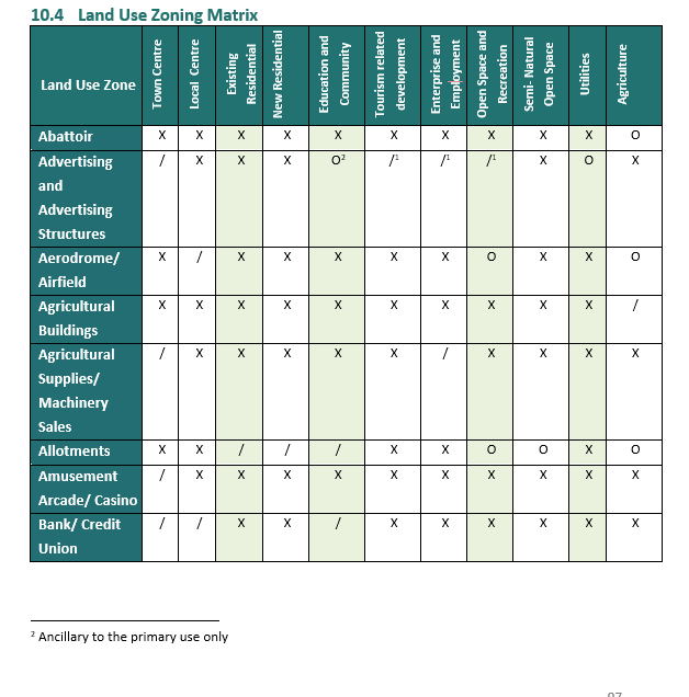
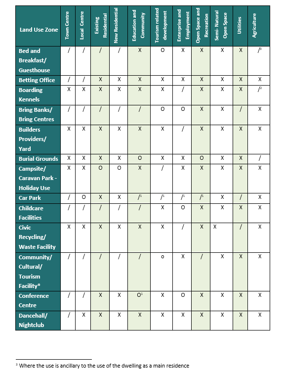
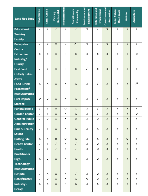
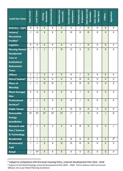
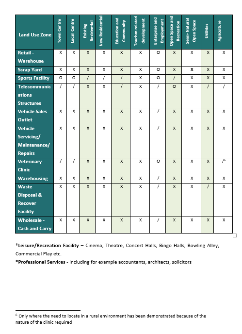
The approach of Limerick City and County Council to various types of developments is determined by the zoning objective for the area in which the site is located. This approach is set out in the following Land Use Zoning Matrix, and should be read in tandem with the Land Use Zoning Map.
The Land Use Zoning Matrix outlines the types of developments considered appropriate or otherwise in each land use zone and are indicated as below.
|
Generally Permitted indicated as / |
A generally permitted use is one the Council accepts in principle in the relevant zone, subject to compliance with all relevant planning criteria, including applicable policies, objectives, development management standards and Section 28 Guidance. |
|
Open for Consideration indicated as O
|
A use open for consideration is one which the Council may permit where it is satisfied that the suggested form of development will be compatible with the policies and objectives for the zone, will not conflict with existing uses or the proper planning and sustainable development of the area. |
|
Generally Not Permitted indicated as X
|
A use incompatible with the zoning policies or objectives for the area, would conflict with the permitted/ existing uses and would be contrary to the proper planning and sustainable development of the area. |
Non-Conforming Uses are uses which do not conform to the zoning objective for the area in which they are located. Where legally established, extensions or improvements to these uses shall be considered on their merits, on a case-by-case basis where they do not adversely affect the amenities of properties in the vicinity, and are not prejudicial to proper planning and sustainable development.
10.2 Advice when submitting a Planning Application
The Planning Authority encourages applicants to avail of pre-planning meetings to discuss policy issues regarding their proposal prior to submitting a planning application. Such meetings are of particular value if specific assessments are required given the sensitivity, type of development and location of the site in Abbeyfeale. Applications are advised to avail of pre-connection enquiries with Uisce Eireann to ascertain if connection to the public mains and sewer is feasible prior to submitting a planning application.
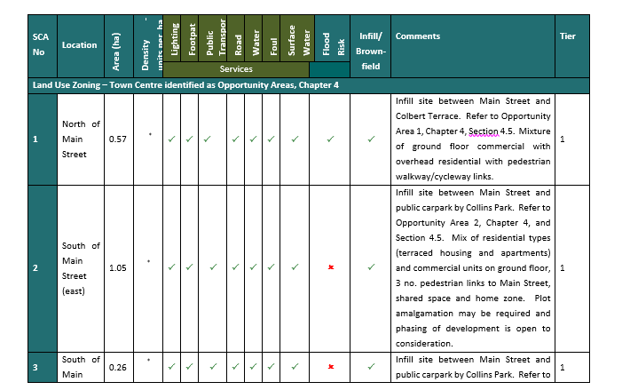
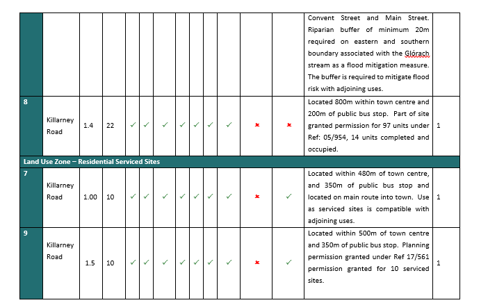
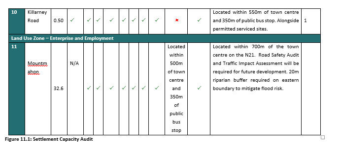
10.5 Settlement Capacity Audit (SCA)
In accordance with Appendix 3 of the National Planning Framework (NPF), the tiered approach to zoning has been applied to zoned lands as laid out in Fig.11.1 below. Tier 1 refers to lands that are adequately serviced and can connect to existing services (road, path, public lighting, water supply and surface water drainage). Tier 2 lands refer to lands that have constraints in terms of connecting to services, but have the potential to become fully serviced over the lifetime of the Plan. The Settlement Capacity Assessment sets out the sites identified for new residential development, serviced sites and enterprise and employment with respect to availability of key infrastructure to ensure that these lands are developable over the lifetime of the plan. The sites are identified as being serviced (utilities), served by public transport and community infrastructure and satisfies the principles of the Ten-Minute Town Concept and compact growth, all promoted by higher-level spatial plans. Where existing infrastructure is located in close proximity to a site and can potentially extended to service the site, these services have been indicated as available. It should be noted that the table below is for information purposes only and developers are advised to avail of pre-planning consultation with the service providers regarding development of these lands prior to submitting a planning application.
|
Legend |
|||
|
Serviced/Yes |
ü |
Serviceable/ Investment required |
! |
|
Not required/No |
û |
Located within a 500m walk |
|
|
Cost (K) |
Cost in Thousands
|
|
|

Contents
Observations
Observations
Dear Sir/Madam
Please see attached and acknowledge receipt of same.
Kind Regards
Annmarie
Dear Sir/Madam
I confirm that St Itas are supportive of any proposed changes to the zoning of part of their lands to facilitate an expansion of Collins lands/yards which lie to the east of St...
Dear Sir/madam
Further to a site meeting today with the area planner Karen Burke and Carina Prendiville representing St Itas, I confirm that St Itas are supportive of the zoning afforded to...