A chara,
Please see attached the OPR submission on the Draft Castleconnell Local Area Plan 2023-2029. Please note that the attached submission applies to the Plan in its entirety.
Kind...
Chapter 1 - Introduction
Closed1 Oct, 2022, 8:00am - 14 Nov, 2022, 5:00pm
The Local Area Plan (LAP) is a statutory document prepared by the Planning Authority, in accordance with the requirements of the Planning and Development Act 2000 (as amended), thereafter referred to as “the Act”. The Castleconnell LAP 2013 - 2019 was extended until 2023 under Section 19 of the Planning and Development Act 2000 (as amended).
The adoption of the LAP is a reserved function of Elected Members of the Metropolitan District of Limerick. This proposed LAP sets out a land use strategy for the proper planning and sustainable development of the village of Castleconnell, complying with the provisions of higher-level spatial plans.
The LAP consists of a written statement and maps indicating objectives for zoning of land, residential development, economic development, community infrastructure, built and natural heritage, open space and recreation, active travel and transport, environmental protection and climate action. This Plan also includes a Settlement Capacity Audit, which informed the quantum and location of the land zoned in the Plan. The written statement generally takes precedence over maps should any discrepancy arise.
Preparation of this LAP has also been informed by Ministerial Guidelines issued pursuant to Section 28 of the Act, together with EU requirements, regarding Strategic Environmental Assessment (SEA) and Appropriate Assessment (AA).
When interpreting the objectives for the village of Castleconnell, it is essential that both the Draft Limerick Development Plan 2022 – 2028 and the Draft LAP are read together.
1.2 Review Process
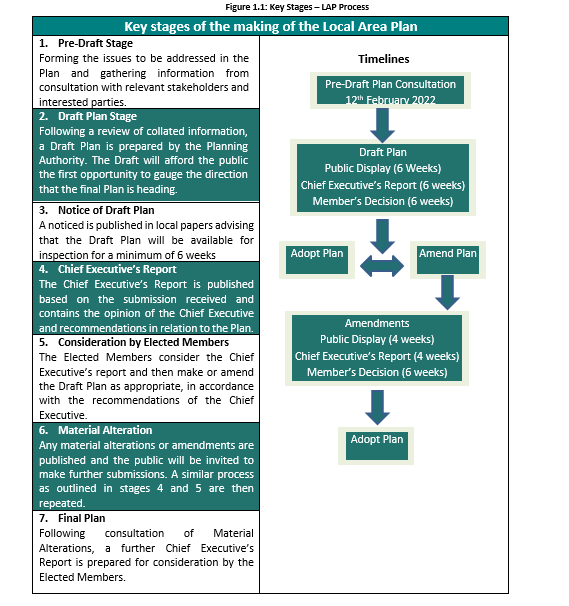
Given the expiration of the extended lifetime of the existing Castleconnell Local Area Plan in 2023, a new LAP is required for the village. Section 20 of the Planning and Development Act 2000 (as amended) sets out the process for the making of a Local Area Plan as outlined in Figure 1 below. The formal process, for the preparation of this Draft Local Area Plan commenced on 12th of February 2022, with the publication of the Issues Paper. Public consultation during this stage of the process, included a schools consultation event, an online webinar, a public consultation evening and an online social media campaign.
Public consultation is an important aspect of any plan-making process, in order to address local issues relating to Castleconnell, and to ensure that the final LAP acknowledges community aspirations and concerns.
During the public consultation period, 39 no. written submissions were received. Preparation of the Draft Plan has been informed by consultations with members of the public including Castleconnell National School, stakeholders, service providers, Elected Members of the Metropolitan District of Limerick, Statutory Bodies, Government Departments and with the various Directorates of Limerick City and County Council.
The publication of the Draft will include a public consultation event in Castleconnell. During this time, written submissions will be invited and considered in a Chief Executive’s Report to be issued to the Elected Members of the Metropolitan District of Limerick. The Planning Authority envisages that the final Plan will be adopted in mid-2023.
The LAP must be consistent with the objectives of the higher-level spatial plans, including the National Planning Framework (NPF), the Regional Spatial and Economic Strategy for the Southern Region (RSES) and the Limerick Development Plan 2022 – 2028.
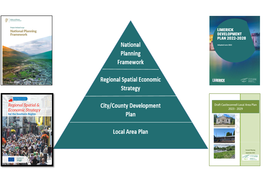
Figure 1.2: Spatial Plan Hierarchy
Spatial Planning Objective 01:
It is an objective of the Council to ensure that provisions of the Draft Castleconnell Local Area Plan 2023 – 2029 for population and economic growth align with the policies and objectives of the higher-level spatial plans, such as the National Planning Framework (NPF), the Regional Spatial and Economic Strategy for the Southern Region (RSES) and the Limerick Development Plan 2022-2028.
In accordance with the Planning and Development Act 2000(as amended), the Draft LAP is subject to the following environmental assessments.
1.4.1 Strategic Environmental Assessment
Strategic Environmental Assessment (SEA) is required in accordance with the SEA Directive (2001/42/EC). SEA is a formal, systematic evaluation of the likely significant environmental effects of implementing a plan, policy or programme. An SEA screening has been carried out and accompanies this plan. It concludes that it is not necessary to progress beyond screening and that full SEA is not required at this stage.
1.4.2 Strategic Flood Risk Assessment
A Stage 1 Strategic Flood Risk Assessment has been prepared in accordance with “The Planning System and Flood Risk Management – Guidelines for Planning Authorities” and Circular PL2/2014 and the information gathered has informed the preparation of the Draft Local Area Plan.
Appropriate Assessment (AA) is required in accordance with Article 6(3) and 6(4) of the EU Habitats Directive (92/43/EEC). AA is a focused and detailed impact assessment of the implications of the plan or project, alone and in combination with other plans and projects, on the integrity of a Natura 2000 site in view of the site’s conservation objectives. Following screening for AA, it was determined that the Draft Castleconnell LAP was likely to have impacts on an area designated as a Natura 2000 site, therefore a Natura Impact Report was required. A Natura Impact Statement accompanies the plan.
The Draft Castleconnell LAP covers approximately 240 hectares in area and falls into the Castleconnell Electoral Division (ED). It contains parts of the townlands of Lacka, Derreen, Cloon and Commons, Coolbane, Coolereiry, Stradbally North and South, Woodpark and Ruan.
In order to ensure compliance with high-level plans, the settlement boundary for Castleconnell is defined by the principle of a compact settlement, prioritising the development potential of the village centre, sequential development from the village centre out and maximising under-used/vacant brownfield infill sites and existing buildings. This is in line with the NPF requirement that the proportion of new homes within the built-up footprint of each settlement should be at least 30% for all settlements. This built up footprint refers to the CSO boundary for Castleconnell,which is marginally smaller than the settlement boundary of the Draft LAP. The Census Data available for the settlement is a crucial element of plan preparation as it provides the only robust, credible, systematic source of data available to analyse at a local level. This includes socio-economic trends and mobility/transport patterns available to support the policies and objectives of the Draft LAP for the sustainable development of the village. Considering the existing built footprint of the village and to align with national spatial policy, the settlement boundary for the Draft LAP has been determined as per the Land Use Zoning Map, Appendix 1.
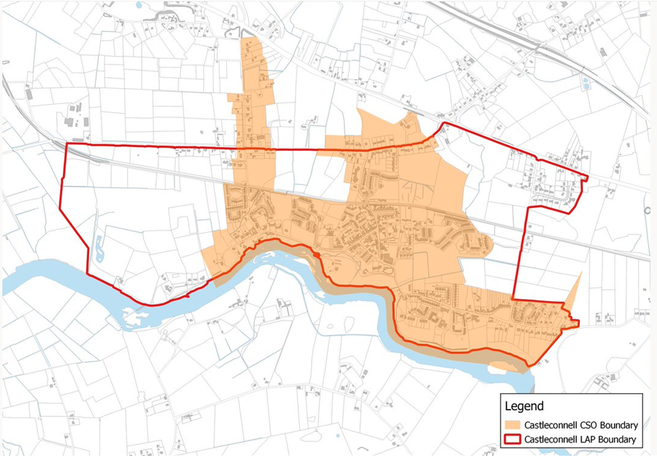
Figure 1.3 Castleconnell Census boundary and LAP boundary
Contents
Observations
Observations
Dear Ms. Burke,
Thank you for your letter of 30 September 2022 regarding the above, the contents of which have been noted.
Transport Infrastructure...