Dear Sir / Madam,
Please find attached the NTA’s submission on the Draft Castleconnell Local Area Plan. Can you please confirm receipt at your earliest convenience....
Chapter 7 - Sustainable Mobility
Closed1 Oct, 2022, 08:00 - 14 Nov, 2022, 17:00
National and regional planning policy emphasises the efficient movement of people and goods, through an integrated multi-modal, accessible and affordable transport network. National Active Travel policy promotes reducing the demand for travel and the reliance on the private car in favour of public transport, car-pooling, cycling and walking as means to promote healthier lifestyles, climate change and improved air quality. A key objective of sustainable travel and its infrastructure is to ensure active travel can be seamlessly built into everyday life as part of normal daily routines, including the commute to school, college or work. A transition towards more sustainable modes of transport is essential to reduce Ireland’s carbon emissions and reach the Government’s goal of a 50% reduction in carbon emissions by 2050.
Compact settlements are conducive to sustaining the critical mass of population or employees to justify infrastructural investment in transport networks. Central to this is the application of the 10 minute town concept whereby all community services, employment opportunities and residences are within walking distance, thereby not requiring transport by car. A fundamental role of a Local Area Plan is to guide the location of land uses considering the integration of good land use planning with transportation. This will unlock significant improvements in quality of life, including more sustainable modes of movement which also have a role in achieving climate targets.
Policy SMT P1: Integration of Land Use and Transport Policies - It is a policy of the Council to
Support and facilitate the integration of land use and transportation policies for Castleconnell, as a means of reducing the impact on climate change. The Council will ensure the delivery of a sustainable compact settlement, which can be served by various modes of transport with a focus on reducing the need to travel.
Policy SMT P2: Transport and Movement - Promotion of Sustainable Patterns of Transport Use : It is a policy of the Council to
Seek to implement in a positive manner, in cooperation with other relevant stakeholders and agencies, the policies of the NPF, RSES and the Department of Transport’s Active Travel publication, to encourage more sustainable patterns of travel and greater use of sustainable forms of transport in Castleconnell, including public transport, cycling and walking.
7.1 Movement and Accessibility
The Council is committed to the development of a network of access routes reflecting the requirements of personal safety, choice and convenience to services and amenities. The access network should facilitate access for all, and should be socially inclusive. These requirements and the desire to minimise dependence on the car for short journeys, means that a permeable matrix type network is preferable to a network with long cul-de-sacs. This plan supports the enhancement of the existing walking and cycling routes in the village as well as the upgrade and creation of new linkages within the village.
There are public and private car parking areas within Castleconnell. The Castlecentre development at Supervalu provides 110 car parking spaces and 8 spaces are provided at the train station. A further 30 car parking spaces are provided at the Ferry Car Park and 20 spaces at Worlds End. On street car parking also takes place in the village centre, which leads to congestion during peak times. To this end, an objective is included in the Plan to support the development of a Traffic Management Plan for the village which will identify and assist in addressing traffic issues. Presently the Council is undertaking work adjacent to the school to improve footpath connectivity and access arrangements.
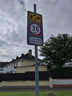
Figure 7.1 – Slow zones Castleconnell
Objective SM 1: Movement and Accessibility: It is an objective of the Council to
- Enhance the walking and cycling networks through the village within the lifetime of the Plan and seek to improve direct pedestrian linkages, cycle networks and infrastructure throughout the village and improve connectivity to the village centre and existing services.
- Deliver a Traffic Management Plan for the village within the lifetime of the Plan, which will consider traffic flow around the village. High quality public realm will be required as part of any village centre redevelopment.
- Facilitate and implement school streets and school zones, including slow zones around the school, and promote/facilitate active travel options for school children to reduce the health and safety risks associated with traffic congestion, pollution and inactive lifestyles. This includes the Safe Routes to School (SRTS) Programme in partnership with the NTA and Green schools.
- Incorporate Sustainable Travel measures in all new developments in the village.
- Protect the existing rail route against encroachment from inappropriate uses that could compromise the long term development of the rail facility and its Park and Ride facility.
- Support the development of a new Park and Ride facility in the village.
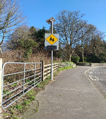
Figure 7.2 – Accessibility signage in the village
In order to achieve more sustainable travel patterns, a significant focus on reducing car dependency and increasing permeability is required as promoted by higher-level spatial plans. These behavioural changes will contribute to healthier lifestyles, lower greenhouse gas emissions and air pollutants, and increase footfall through the village. Vehicles often dominate the streets and vehicle movement can be detrimental to vibrancy and livability of the village, as well as depleting public realm and creating safety issues for pedestrians and cyclists. Redesigning our streets to prioritise walking, cycling and other non-motorised wheel-based modes is just one crucial aspect of enabling and creating a modal shift from the private car. We also need to support individual citizens to make the choice to active travel through behavioural change projects and support initiatives.
Bus services in the village consists of seven return daily services, operated by Bus Eireann to Limerick City, at a number of locations around the village. The railway station in Castleconnell is located centrally in the village and has a parking area to facilitate park and ride. A twice daily rail service runs from the village to Limerick City. In line with national transport and planning policy, the Council welcomes any improvement to public transport services and infrastructure within the lifetime of this Plan. Improvements to connectivity for the daily commute to the wider Limerick City and County are encouraged by the Council to improve accessibility to the services, employment and the educational opportunities of Limerick City.
In accordance to the 2016 Census, just 8% of persons aged 5 years + walked to work, school or college in Castleconnell. In the 2011 Census, this mode of commute accounted for the same percentage of daily journeys. Less than 1% cycled in 2016 which is in line with the figures from the 2011 Census. In the 2011 Census 6% of commuters took the bus and by 2016 this had increased marginally to 8%. The car is still the dominant means of travelling to work, school or college in Castleconnell and either as a driver or as a passenger it accounts for 75% of journeys. Again this is in line with the figures recorded in 2011(75%). Figure 7.3 below outlines the means of travel to work, school or college of all persons over the age of 5 in Castleconnell.
These Census figures are substantially below current national government policy for modern transport, including active travel. With a compact settlement offering a range of residential choice, with access to the services and amenities that Castleconnell currently processes, supports for better connectivity and choice of mode of movement in a safe, efficient and the affordable integrated mobility network there is potential for Castleconnell to progress towards reaching the national targets for more sustainable travel.
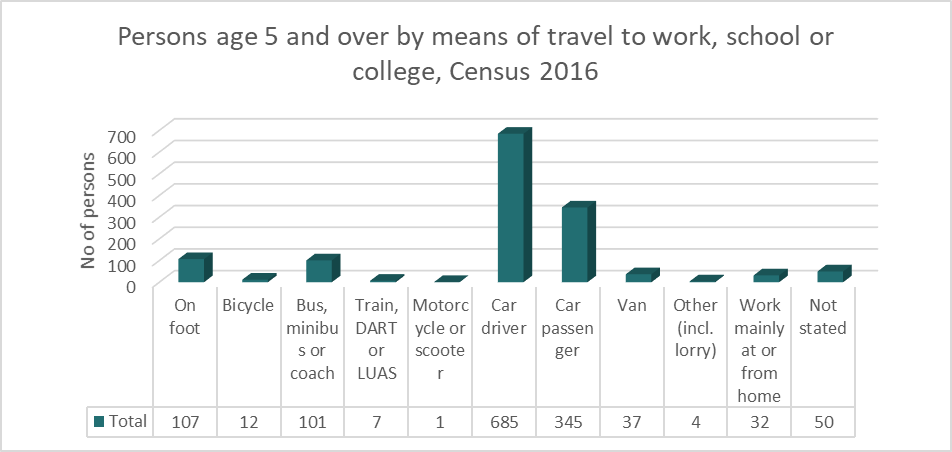
Figure 7.3: Persons Aged 5 years + mode of commute to work, school or college in Castleconnell, Census 2016
The Limerick Development Plan 2022 – 2028 sets the following targets for the modal shift for Tier 3 settlements which includes Castleconnell.
|
Settlement
|
Walk |
Cycle |
Public Transport |
|
Settlement Levels 3-6/Rural Areas (All Work/Education Trips) |
15% |
5% |
12% |
Table 5: Mode Shift Targets for commute to work, school or college, by 2028
While there are challenges facing Castleconnell, with regard to promoting a modal shift away from the private car, this Local Area Plan strives to reduce the reliance on the private car, by promoting and facilitating more sustainable modes of transport, based on the principles of the 10 minute town concept, a compact settlement and the town centre first approach. The Council will co-operate closely with other relevant agencies and stakeholders, including the NTA and TII to address modal shift targets as above.
Objective SM 2: Modal Shift and Behavioural Change: It is an objective of the Council to:
- Encourage, promote and facilitate a modal shift towards more sustainable forms of transport in Castleconnell.
- Support and facilitate implementation of an integrated, multi-modal and accessible public transport network catering for all members of society across Castleconnell and its hinterland.
- Collaborate with transport providers to improve timetabling, information display and connectivity to adjacent settlements and Limerick City. All future development proposals shall incorporate the relevant objectives of the Limerick Shannon Metropolitan Area Transport Strategy (LSMATS) or any updates thereof.
Castleconnell is readily accessible by the regional roads, the R445 and R525, which provides easy access to Limerick City and the adjoining settlements. The eastern boundary of the plan area is the old Limerick/Dublin national road. Since the opening of the M7 motorway, this road has been downgraded to a regional road. Access and egress from the approach road to Castleconnell is now much easier, quicker and safer due to the reduced amount of traffic using this road. In total there are four approach roads to the village, the main approach route being at the junction of Daly’s Cross and the R445, which continues onto Montpelier and O’ Briensbridge. The other approach roads are at the junction of the Belmount Road and the R445 and further north branching off the R445 passing through Nelsons Cross onto Lacka Road. Also the back road through Lisnagry serves Castleconnell from the southwest.
Castleconnell also benefits from its riverside location and the off road walkway/cycleways along the river’s edge. While these pathways provide a special amenity to the village there are opportunities to extend them through connection to adjoining areas and the wider greenway/active travel network. In this regard a feasibility study is presently underway to establish the scope for a connection from UL to Castleconnell and onward to Montpelier. This network would provide further opportunities for active mobility by walking and cycling with its connections to Limerick City and potentially into the adjoining Counties.
Objective SM 3: Roads: It is an objective of the Council to:
- Protect the capacity of the regional road network from inappropriate development, having regard to all relevant Government guidance and Objective TR 041 Strategic Regional Roads of the Limerick Development Plan 2022-2028 and ensure development does not compromise the performance of the network or future improvements to network.
- Prohibit advertising signage adjacent to the regional road networks.
- Ensure all developments protect and safeguard the capacity and efficiency of the drainage regimes of the regional and local network.
Contents
Observations
Observations