


see attached
Chapter 8 - Climate Action, Environment and Heritage
Closed1 Oct, 2022, 8:00am - 14 Nov, 2022, 5:00pm
8.1 Climate Action and the Environment
Climate change and the transition to a low carbon society has become a critical element of all land use plans. The effects of climate change is quickly becoming the biggest challenge facing society today posing a serious threat to quality of life, communities, businesses, the environment and biodiversity. Land use planning is a critical tool to mitigate and adapt to climate change and to the protection of our environment. Implementation of the LAP will take into account relevant targets and actions arising from sectoral plans in order to comply with the requirements of the Climate Action and Low Carbon Development (Amendment) Act 2021. This supports Ireland’s transition to Net Zero and achieving a climate neutral economy by no later than 2050.
The Limerick City and County Council Climate Change Adaptation Strategy 2019 - 2024 outlines that Climate Action comprising of two elements – (1) Adaptation and; (2) Mitigation. Adaptation is the efforts to manage the risks and impacts associated with existing or anticipated impacts of climate change, while mitigation is the efforts to reduce the emission of greenhouse gases, and reduces the severity of future climate change impacts.
Through the policies and objectives set out in the NPF and RSES, Climate adaptation and mitigation measures are embedded in the plan-making process. The Draft Local Area Plan has been prepared with the purpose of integrating and implementing these policies and provisions where relevant. The approach to density, land use, design and movement is consistent with broader measures to address climate change in the areas of sustainable travel, green infrastructure, flood risk adaptation and renewable energy sources, amongst others.
There are a number of ways in which a Local Area Plan can seek to reduce the carbon footprints and mitigate against the negative impacts of climate change. These include:
- Promoting the provision of blue green infrastructure (planting of trees, hedgerows, woodlands, construction of surface water retention features, such as ponds, lakes or swales);
- Promoting climate proofing in the design of buildings and neighbourhoods;
- Promoting the use of indigenous resources and adaption of new building techniques and designs that minimize energy intensive inputs;
- Seek to improve energy performance ratings on existing and new buildings. All new homes constructed must reach an energy performance rating in accordance with Part L – Conservation of Fuel and Energy 2019, which gives effect to Nearly Zero Energy Building (NZEB) Regulations.
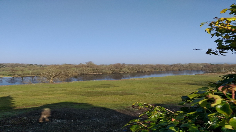
Figure 8.1 – Vista from Castleconnell Castle to the River Shannon
Policy CH 1: Climate Change: It is a policy of the Council to
Protect and enhance environmental quality and implement the climate action measures through the planning process to help address climate change.
Objective CH 1: Climate Change: It is an objective of the Council to
- Ensure climate-proofing measures are incorporated into the design, planning and construction of all developments, including utilities and their networks. The use of green infrastructure as a mechanism for carbon offsetting and surface water management is encouraged.
- Ensure that all residential and commercial developments are designed to take account of the impacts of climate change, including the installation of rainwater harvesting systems, and that energy efficiency and renewable energy measures are incorporated. In the case of large industrial, commercial or newly constructed public buildings, the incorporation of renewable technologies, such as solar energy in the design will be encouraged, subject to compliance with all relevant planning criteria.
- Support and promote climate smart and the NZEB standard of building or equivalent for all new developments.
- Promote and support development of renewable energy sources, which will achieve low carbon outputs and promote Castleconnell as a low carbon area
- Support the development of low carbon and green technological businesses and industries.
- Promote responsible development and management of land, drainage systems and natural habitats and to encourage development at appropriate locations, which minimise the use of fossil fuels and maximises the use of local or renewable resources.
8.2 Biodiversity and Blue green infrastructure
Blue green infrastructure refers to the incorporation of blue elements (water environments), like rivers, canals, ponds, wetlands, floodplains, water treatment facilities, and green elements, such as trees, forests, fields and parks, in urban and land-use planning. This infrastructure uses natural processes, such as filtration or absorption to address water and air quality. In some instances blue and green infrastructure can exist side by side in a complimentary relationship, such as the River Shannon, its banks, and mature trees. This Plan promotes networks of blue green infrastructure as aligned with higher-level plans, including the Limerick Development Plan 2022-2028.
This Draft Local Area Plan can help mitigate further impact on the environment through ensuring that future development takes cognisance of the natural elements of sites and incorporates them within the design of buildings and neighbourhoods, connecting them into the wider blue green infrastructure network. Where there are no natural site features present, the potential for a landscaping plan to re-establish green features and infrastructure should be examined.
Castleconnell is located within the Shannon Coastal Zone Landscape Character Area, as set out in the Limerick Development Plan 2022-2028 and the presence of the River is the defining characteristic of the village. A wide diversity of species, habitats, ecosystems and landscapes make up the biodiversity of the village. Connected green spaces provide the greatest benefit to biodiversity in an urban context. In this regard, there is an opportunity to recognise the key conservation role the River Shannon plays in the village’s biodiversity. Existing trees and hedgerows are an important features supporting biodiversity and should be carefully considered in any planning application. Applications shall seek to retain hedgerows, landscaped areas, retention or planting of trees and preservation of natural features etc where possible. Suitable planting new edge or buffer treatments will be encouraged as part of new developments. These areas will emphasize enhancement of local biodiversity and local surface water management, while enhancing visual amenity. Management of invasive species, prior to and during construction shall be considered.
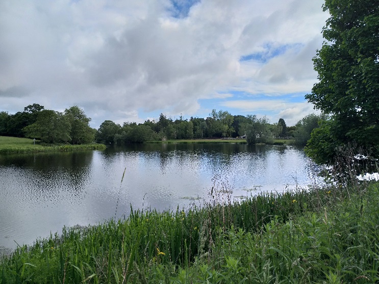
Figure 8.2: Blue Green Infrastructure in Castleconnell
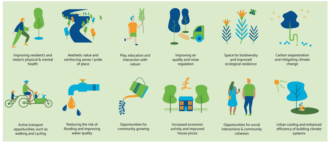
Figure 8.3: Blue green Infrastructure benefits (Image courtesy of Draft Limerick City and Environs Blue Green Infrastructure Strategy.
Limerick City and County Council are currently undertaking a Blue Green Infrastructure Strategy, which will be used to inform and guide the planning and management of BGI within Limerick City and Suburbs. Many of the BGI principles will be relevant to Castleconnell. BGI has far-reaching benefits, including the creation of places, which improve physical and mental health, contributes towards the provision of space for nature, and plays a vital role in climate change mitigation and adaptation along with many economic benefits.
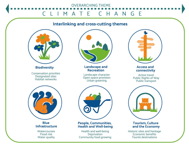
This strategy identifies a number of specific themes which are both interlinked and cross cutting. The Draft Local Area Plan for Castleconnell, includes a number of policies and objectives that will guide the direction and support the delivery and enhancement of BGI within the village. These ‘Enhancement Opportunities’ are outlined in Table 6 and includes the associated key cross compatible Climate Change themes.
Fig 8.4: Image taken from Draft Limerick City and Environs Blue Green Infrastructure Strategy: Climate Change Interlinking and Cross-cutting Themes
|
Enhancements Opportunities |
Theme |
|
|
|
|
|
|
|
|
|
|
|
|
|
|
|
|
|
|
|
|
|
|
Table 6: LAP Climate Action Opportunities
|
Feature |
Local name |
Condition/Description |
Asset Value |
|
River Shannon |
As indicated |
Good – Designated a Special Area of Conservation. Riverside/Forest Walk at the rear of the Castle Oaks Hotel. |
The riverside walk facilitates a looped walk in the village, access via a footbridge to wider walkways in County Clare and potential to link into any extended walkway from UL to Montpelier. Mature trees and a fairywood are located on the pathway – biodiversity corridor, connectivity, active lifestyles. |
|
Local walking loops |
Sli na Slainte |
|
Looped walking routes for the village, well used and popular among locals – infrastructural upgrades needed in places - public amenity value, connectivity and lifestyle. |
|
Playground |
Castleconnell Community Playground |
Relatively good condition, equipment needs upgrading within the lifetime of the Plan. |
Social interaction, active lifestyle |
|
Opportunity Site 1 site area 1.12 ha |
As indicated |
The site consists of an enclosed field, separated from the adjoining graveyard by a concrete wall, Bruach na Sionna by a high stone wall, The Tontines housing development by a mature hedgerow and palisade fencing and Scanlon Park by a concrete post and wire fence with a gated entrance. |
Opportunity site for the development of a park overlooked by new residential development. The park will establish linkages and connectivity, social interaction, public amenity value and offers ecological potential. |
|
Opportunity Site 2 Worlds End site area of 48.87 ha |
As indicated |
Important access point to the river and wider area. Any works in this area will require a comprehensive masterplan and appropriate Environmental Assessments to determine if there are any significant effects on the ecology of the Natura 2000 site.
|
This area has been identified as a valuable amenity that has potential for further appropriate development in the interests of habitat protection and recreational amenity. It currently offers amenity space with a car park, slipway to the river and access to walkway along the river and into woodlands. The potential development of an amenity resource offer further potential. It is important to protect and enable this area to work as an amenity space for the whole village – social interaction, public amenity value, connectivity. |
Table 7: Inventory of Blue Green Infrastructure
Objective CH 02: Blue Green Infrastructure: It is an objective of the Council to
a) Develop and enhance blue and green infrastructure opportunities throughout Castleconnell and in line with the detail set out in Table 6: LAP Climate Action Opportunities.
b) Promote connecting corridors for the movement of species and encourage the retention and creation of features of biodiversity value, ecological corridors and networks that connect areas of high conservation value such as woodlands, hedgerows, earth banks, watercourses, wetlands and designated sites where possible. In this regard, new infrastructural projects and linear developments in particular, will have to demonstrate at design stage, sufficient measures to assist in the conservation of and dispersal of species.
c) Where possible remove barriers to species movement, such as the removal of in-stream barriers to fish passage for example.
8.2.1 Water Framework Directive
The European Union Water Framework Directive (WFD) was signed into law in October 2000. The Water Framework Directive (WFD) brings an integrated approach to managing water quality on a river basin (catchment) basis, in order to protect and enhance both ecological and chemical quality of rivers, lakes, groundwater, estuaries and coastal waters.
The WFD is implemented through River Basin Management Plans (RBMPs) in three six-year cycles. Each cycle providing an opportunity to assess water conditions at different stages and set out actions to achieve water quality objectives. The third cycle runs from 2022-2027. Local authorities are responsible for the development and implementation of RBMPs at a local level.
Policy CH 2 Water Framework Directive Policy: It is a policy of the Council to:
Implement changes to the management of water bodies, taking account of all aspects of the Water Cycle in accordance with the Water Framework Directive and the principal objective of the WFD to achieve good status in all waters and to ensure that status does not deteriorate in any waters.
The Draft LAP seeks to protect the ecological integrity of the river by maintaining a buffer zone along the River Shannon, which prevents the encroachment of future development onto the riverbank as recommended by Inland Fisheries Ireland.
The River Shannon remains of central importance to the village and is recognised as an important amenity and is valued as a natural habitat. Natura 2000 is a European network of important ecological sites. The EU Habitats Directive (92/43/EEC) placed an obligation on Member States of the EU to establish the Natura 2000 network. The network is made up of Special Protection Areas (SPAs), established under the EU Birds Directive (79/409/EEC), and SACs, established under the Habitats Directive itself. The River Shannon has been designated as a Special Area of Conservation. This designation has implications for development, in terms of buffer zones, but also constitutes an opportunity, as the designation of such areas is generally in recognition of good species, diversity and river quality, which would have implications for angling activities.
The lands adjoining the river are zoned as a Special Control Area. This zoning recognises the importance of the natural habitat of the River Shannon. Development including, holiday homes and holiday apartment shall not be permitted on lands zoned special control area. Ancillary leisure/tourism development may be permitted, where it can be satisfactorily demonstrated that there will be no impact on the integrity of this Special Control Area or on the natural habitat of the river and its designation as part of the Lower River Shannon Special Area of Conservation. The extension, expansion or conversion of existing non-conforming uses in this special control zone shall be assessed on their merit.
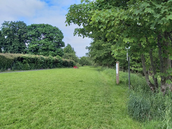
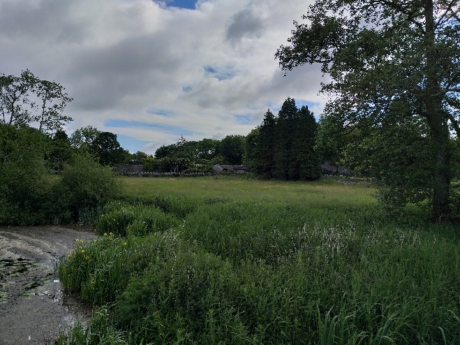
Figure 8.3 – Special Control Area Castleconnell
Indicative walkways have been indicated on the Land Use Zoning Map in the Draft Plan. These contribute to the role of the river as an amenity and can also help to reinforce the idea of a buffer zone between the river and development. Careful consideration must be given to any impact upgrade or extension works relating to walkways would have on the integrity of the Lower River Shannon Special Area of Conservation.
There are a number of impressive trees groups and freestanding trees that exist particularly along the River walk from the village centre south to Doonass Falls and on the lands opposite the castle. These are particular landscape features which future development patterns should have regard to. A number of field boundaries within the plan area, while lacking mature impressive trees, nonetheless form an essential part of the natural fabric of the area.
Another important feature in Castleconnell is the natural stone boundary walls. These should be retained where possible and be integrated into future developments.
This Local Area Plan seeks to protect, preserve and enhance the natural heritage for the benefit of future generation as well as safeguarding the continued and sustainable use of this asset.
Objective CH 04: Special Control Area: It is an objective of the Council to
- Protect and maintain the integrity of the Special Control Area and protect the watercourses in Castleconnell providing a buffer zone, in accordance with the Special Control Area zoning designation on the Land Use Zoning Map;
- Ensure that development including holiday homes and holiday apartments shall not be permitted on land zoned special control area. Ancillary leisure/tourism development may be permitted, where it can be satisfactorily demonstrated that there will be no impact on the integrity of this Special Control Area or on the natural habitat of the River and its designation as part of Lower River Shannon Special Area of Conservation.
Objective CH 05: Tree Protection and Nature Conservation: It is an objective of the Council to
Seek to protect natural stone boundary walls, ponds/wetlands, other natural features of local importance and mature trees, where possible. Development that requires the felling or harming of such trees will not generally be permitted, unless supported by a tree survey establishing that the subject trees are of no ecological or amenity value. Such report shall be undertaken by a suitably qualified and competent person.
Objective CH 06: Designated Sites and Nature Conservation: It is an objective of the Council to
a) Protect the integrity of the Lower River Shannon Special Area of Conservation site, through the establishment of buffer zones along the river.
b) Ensure that appropriate waste water infrastructure is available to support new developments to safeguard water quality.
c) No projects which will be reasonably likely to give rise to significant adverse direct or indirect or secondary impacts on the integrity of any Natura 2000 sites, having regard to their conservation objectives arising from reduction in species diversity, shall be permitted on the basis of this plan (either individually or in combination with other plans or projects).
8.3 Built Heritage and Archaeology
There are 37 Protected Structures in Castleconnell and 30 of these structures are also listed on the National Inventory of Architectural Heritage (NIAH) such is their significance at a regional and national level. The diversity of structures on the Record of Protected Structures lists, includes railway buildings, religious buildings, the buildings and terraces of the traditional vernacular streetscape and shopfronts, mausoleums and medieval structures (Refer to Appendix III). There is an onus on the owner and/or occupier of a protected structure to ensure that the structure or any element of it is not endangered. Endangering a structure can mean either directly or indirectly damaging any element of the structure or neglecting the structure to the extent that it is damaged. When considering works, including minor works to a Protected Structure you are advised to contact the Conservation Officer to ascertain obligations in terms of the proposed development to avoid damage to the integrity of the historical built fabric of the structure. Some minor works, while exempt from planning permission in general circumstances may not apply to Protected Structures.
Limerick City and County Council is obliged to compile and maintain a Record of Protected Structures (RPS) under the provisions of the Planning and Development Act 2000 (as amended). Under the Act, Local Authorities must include objectives for the protection of structures, or parts of structures, which are of special architectural, historical, archaeological, artistic, cultural, scientific, social or technical interest. The complete list for Limerick City and County is available as Volume 3 of the Limerick Development Plan. A Protected Structure, unless otherwise stated, includes the interior of the structure, the land lying within the curtilage of the structure, and other structures lying within that curtilage and their interiors. The protection also extends to boundary treatments.
The National Inventory of Architectural Heritage (NIAH) was established under the provisions of the Architectural Heritage (National Inventory) and Historic Monuments (Miscellaneous Provisions) Act 1999. The purpose of the NIAH is to identify, record and evaluate post 1700 architectural heritage. The Department of Culture, Heritage and the Gaeltacht carried out the survey to inform the preparation of the NIAH.
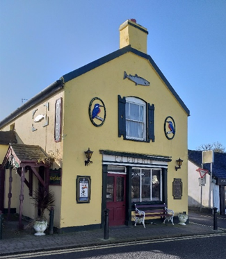
Figure 8.4 – Guerins Pub
8.3.2 Architectural Conservation Areas (ACA)
Castleconnell has three main areas of architectural interest: the northern ACA, the central core ACA and the southern ACA. Throughout these areas the River Shannon’s presence is a significant topographical feature and it makes an immense contribution to the character and ambience of Castleconnell and its surrounds. The collective arrangement of buildings within these areas are considered of significance to the built heritage of the village and contributes to the character and established street and townscape. It is the objective of the Council to preserve the character of these areas and therefore they are designated as Architectural Conservation Areas (ACA). The ACA is defined in the Protected Structures and ACA Map 3. The designation of the ACA does not preclude future development, but the carrying out of works to the exterior of structures within the ACA shall not be considered as exempted development where those works would materially affect the character of the ACA. In assessing development proposals within the ACA, the Council shall take into account the material effect that the proposed development would be likely to have on the character of the ACA.
The northern ACA was a significant area of economic and social activity. The spa-well, still extant, was the focus of activity and during the early part of the 19th century a building knows as the Assembly Rooms was built between it and the Shannon. Around this location were a number of country houses and landmark buildings such as a Hotel and the Police Barracks and also the high amenity area of Worlds End.
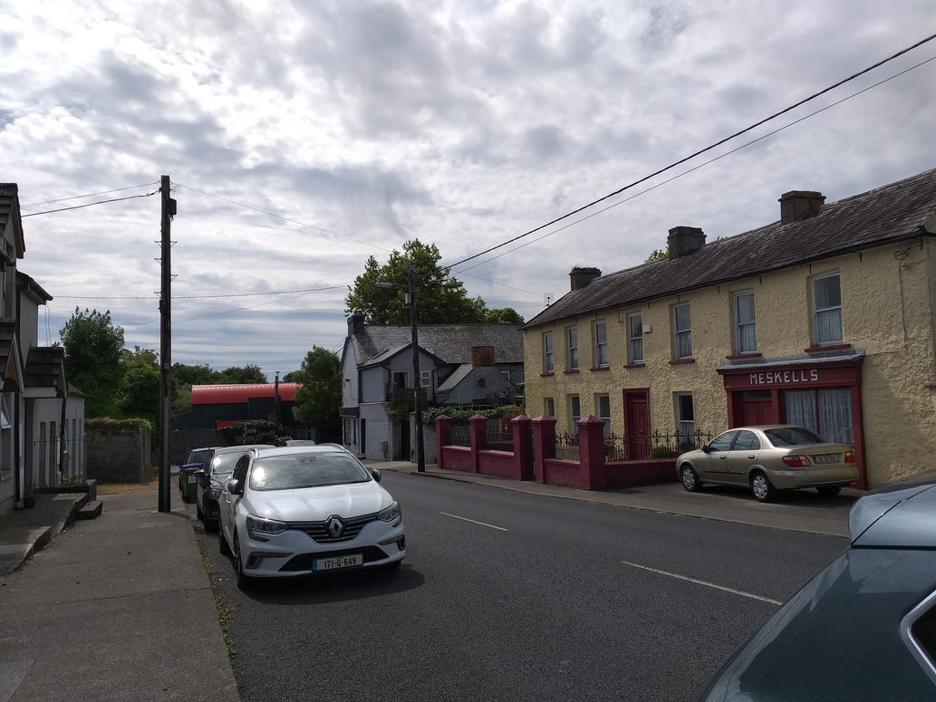
Figure 8.5 – Part of northern ACA
Significant buildings in this area, include Lacka House, two semi-detached houses to its south-east and their neighbouring building; Grange House and the complex of structures associated with the chalybeate well to its south, the former Charco’s Public House on the junction and, to its east, Meskell’s Shop and its associated residence.
During the latter half of the 19th century, the layout of the approach road into the core of Castleconnell from the south was altered. The primary effect of these modifications was to bring the ruins of Castle Connell, from which the village takes its name, into the grounds of Stormont, one of the many houses constructed along the banks of the River Shannon. The second effect of this road alteration was the formation of a triangular space which was to become the core of the village, the location of several amenities, and the focal point of economic and civic activities. The eastern side of the triangle became the location for the Roman Catholic Church and the national school, with its attached teacher’s residence. To the eastern and southern side of the triangle, structures were demolished and replaced with new buildings, or altered and put to new use. Within this area there are buildings considered to have stature, such as Island House and the church, or to have a distinct character, such as The Tontines, and historical importance, such as the former Shannon Hotel. There are more modest structures, such as the terraced cottages along the southern side of the triangle.
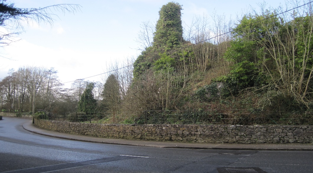
Figure 8.6 - Ruin of Castle Connell
The building lines found in Castleconnell are similar to those found in many Irish towns and villages. Each individual building, tended to have its own distinct plot of land. The buildings tended to be constructed in terraces, though this was not adhered to in all instances. While many of the buildings within the centre of Castleconnell’s historic core, address the footpaths directly, many are characterised by a distinct set-back which can be demarked by a small front garden, or a yard undifferentiated from the path through the use of a boundary wall.
The lands within the Southern ACA comprises of former small estates and demesne lands associated with country houses, some of which have survived, though modified and altered. The essential feature of these houses was the prized views and vistas of the River Shannon to be had from their principal rooms and locations within the property. Land management features, such as ha-has, which allowed for uninterrupted views of the river’s waters, still survive, along with demesne walls, gateways, and the occasional building associated with the estates. The value of the landscape, and its contribution to the amenities and character is highly valued and every effort has been made to preserve the views down to, and across the River Shannon. A notable feature in recent years has been the construction of new houses that reflect the period of design and creation. The planning authority welcomes development and encourages it as a reflection of best practice in the area of architecture.
In undertaking repairs or maintenance works to buildings in the Castleconnell Architectural Conservation Area, property owners and their contractors should be aware of the materials traditionally used in the county, and more specifically, in the village itself and its immediate surrounds.
Works in Conservation Areas must retain existing surviving elements, aim to re-instate lost elements or character, with new builds complementing the original streetscapes, building lines and open areas. Proposals for new buildings should not seek to dominate the historic core and should respect the historic fabric of the buildings and the morphology of their plots.
Where original or early surviving elements, such as windows and doors, rainwater goods of rolled mild steel or cast iron (or a combination of both), natural slate roofing and lime renders, and so forth, then these should be repaired sensitively. The guidance here is to “do as much as necessary and as little as possible”. If replacement proves necessary, then they must be replaced on a “like-for-like” basis.
In replacing elements that were installed as replacements in recent decades, such as aluminium windows or smooth finish artificial slate, there are good reasons, apart from those put forward on the basis of architectural heritage, to return to the original materials, such as timber windows and natural slate. These reasons include the compatibility of traditional materials with one another and the fact that the historic material allows the building to breathe, thereby providing a healthier internal atmosphere for those using the buildings.
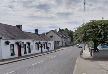
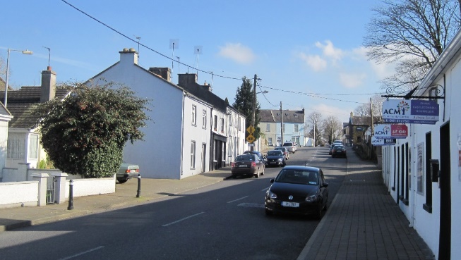 Figure 8.7 Part of the ACA on Castle Street
Objective CH 07: Protected Structures: It is an objective of the Council to
Resist the demolition of Protected Structures, in whole or in part, the removal or modification of features of architectural importance, and design element that would adversely affect the character or setting of a Protected Structure, unless exceptional circumstances can be clearly demonstrated by a suitably qualified professional.
Objective CH 08: Architectural Conservation Areas (ACA’s): It is the objective of the Council to:
- Protect, conserve and where appropriate, enhance the ACA’s as identified in Map 3.
- Proposals for development within the ACA’s shall;
- Reflect and respect the scale and form of existing structures within the ACA’s in proportioning, overall scale and use of materials and finishes, particularly with reference to the street frontages and seek to contribute to or enhance the character and streetscape of the ACA’s;
- Seek to retain/incorporate/replicate exterior features which contribute or enhance the character and streetscape of the ACA’s such as shop fronts, sash windows, gutters and down pipes, decorative plasterwork etc;
- Ensure priority is given to the pedestrian, to inclusive access, and to facilitating the improvement of the quality of the public realm: the latter will include for consideration of the planting of trees in the wider public open spaces, benches for sitting and the articulation of uses through appropriate paving.
Castleconnell has a significant cluster of early and medieval monuments, suggesting that the area was the nucleus of a settlement at least from medieval times. There is also significant evidence of much earlier occupation surrounding the village outside the LAP boundary. Significant discoveries dating to the Mesolithic period have been made in the adjoining townland of Hermitage. Castleconnell's location on the banks of the River Shannon is particularly significant. There are 12 individual monuments within the Local Area Plan boundary. All of these monuments are contained within the boundary of the historic town as shown on the accompanying map in Appendix IV. The location of each archaeological monument is provided in the Record of Monuments and Places, which is maintained and up-dated by the Archaeological Survey of Ireland, a branch of the National Monuments Service. Under the provisions of the National Monuments Act Section 12, 1994 Amendment any person proposing any works (this includes exempted development) ‘at or in relation to such a monument’ has to give written notification two months in advance to the Minister for the Department of Housing, Local Government and Heritage. Sites continue to be discovered, some of those found subsequent to the publication (1997) have been included in the Site and Monuments Database which is available on the website www.archaeology.ie. Under Section 14 of the National Monuments (Amendment) Act 2004, proposed development or works within or in the vicinity of archaeological monuments in Local Authority or State ownership or guardianship may require authorisation in the form of Ministerial Consent to proceed and the National Monuments Service, Department of Housing, Local Government and Heritage shall be consulted in this regard in advance of site works. Proposed developments and/or works, dredging schemes etc. within or in the vicinity of watercourses have the potential to impact on previously unrecorded wrecks or small craft that may be over 100-years old and which are therefore protected under the National Monuments (Amendment) Act 1987. The Underwater Archaeological Unit of the National Monuments Service, Department of Housing, Local Government and Heritage shall be consulted in advance of any works on the River Shannon.
Figure 8.8 – Castleconnell graveyard
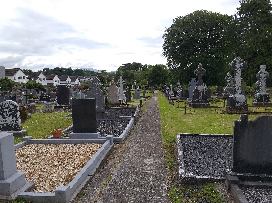
Limerick City and County Council is committed to protecting the archaeological heritage, including the preservation of unrecorded or newly discovered archaeological material. Consequently, the planning authority will include a condition of archaeological monitoring on developments whose scale and nature may have an impact on previously unknown archaeological materials.
Objective CH 09: Archaeological Heritage: It is the objective of the Council to:
- Seek the preservation (in situ, or at a minimum, preservation by record) of all known sites and features of historical and archaeological interest. This is to include all the sites listed in the Record of Monuments and Places as established under Section 12 of the National Monuments (Amendment) Act 1994.
- Protect and preserve (in situ, or at a minimum, preservation by record) all sites and features of historical interest discovered subsequent to the publication of the Record of Monuments and Places.
- Ensure that any proposed development shall not have a negative impact on the character or setting of an archaeological monument.
- Ensure that the area of a monument and the associated buffer area shall not be included as part of the open space requirement demanded of a specific development, but should be additional to the required open spaces, and if appropriate, where such a monument lies within a development, a conservation and/or management plan for that monument shall be submitted as part of the landscape plan for that development.
Contents
Observations
Observations
Please find attached the OPW Flood Risk Management Submission for the Castleconnell Local Area Plan
Comments on parts of Chapter 8
The Castleconnell Local Area Plan is looking really good. I have some points below on Chapter 8 which I hope you will find useful.
R525 Looped Walk
The R525 is a narrow hard...