

Please see our submission attached
Updated Strategic Flood Risk Assessment
Closed28 Jan, 2023, 8:00am - 27 Feb, 2023, 5:00pm
Table of Contents
2.0 Flood Risk Management Policy
2.2.1 National CFRAM Programme
2.2.2 Flood Risk Management Guidelines
3.1 Introduction – Stage 1 Flood Risk Identification
3.3 Conclusion of Stage 1 SFRA
4.0 Stage 2 Strategic Flood Risk Assessment
4.1 Assessment of information outlined above and Delineation of Flood Zones
4.2 Flooding from Other Sources
4.5 Climate change considerations
5.0 Recommendations and Integration with Local Area Plan
5.2 Integration of provisions of Flood Risk Assessment and Flood Management into the Local Area Plan
Appendix I - Flood Justification Tests
The preparation of the Castleconnell Local Area Plan has been subject to a Strategic Flood Risk Assessment (SFRA), in accordance with The Planning System and Flood Risk Management - Guidelines for Planning Authorities (Department of the Environment, Heritage and Local Government and Office of Public Works, 2009) and Department of the Environment, Community and Local Government Circular PL 2/2014. The SFRA provides an assessment of flood risk and includes mapped extents of Flood Risk Zones. This report considers flood extents to inform the preparation of a land use plan.
The Local Area Plan is a land use plan and provides an overall strategy for the proper planning and sustainable development of the functional area of the village of Castleconnell over the six-year period 2023 – 2029. The principles on which the plan has been developed upon is compact growth, promotion of a self-sustaining settlement supported by sustainable transport choices, to promote the growth of the village, in an environmental manner.
Castleconnell is located approximately 10 kilometres northeast of Limerick City. The village adjoins the River Shannon, which is the county boundary between Counties Limerick and Clare. The village has developed in a linear fashion along the banks of the River Shannon with the Main Street running parallel to the River. The topography of Castleconnell and surrounding areas is largely low-lying. Flood risk in Castleconnell is largely dominated by the River Shannon and its associated tributaries.
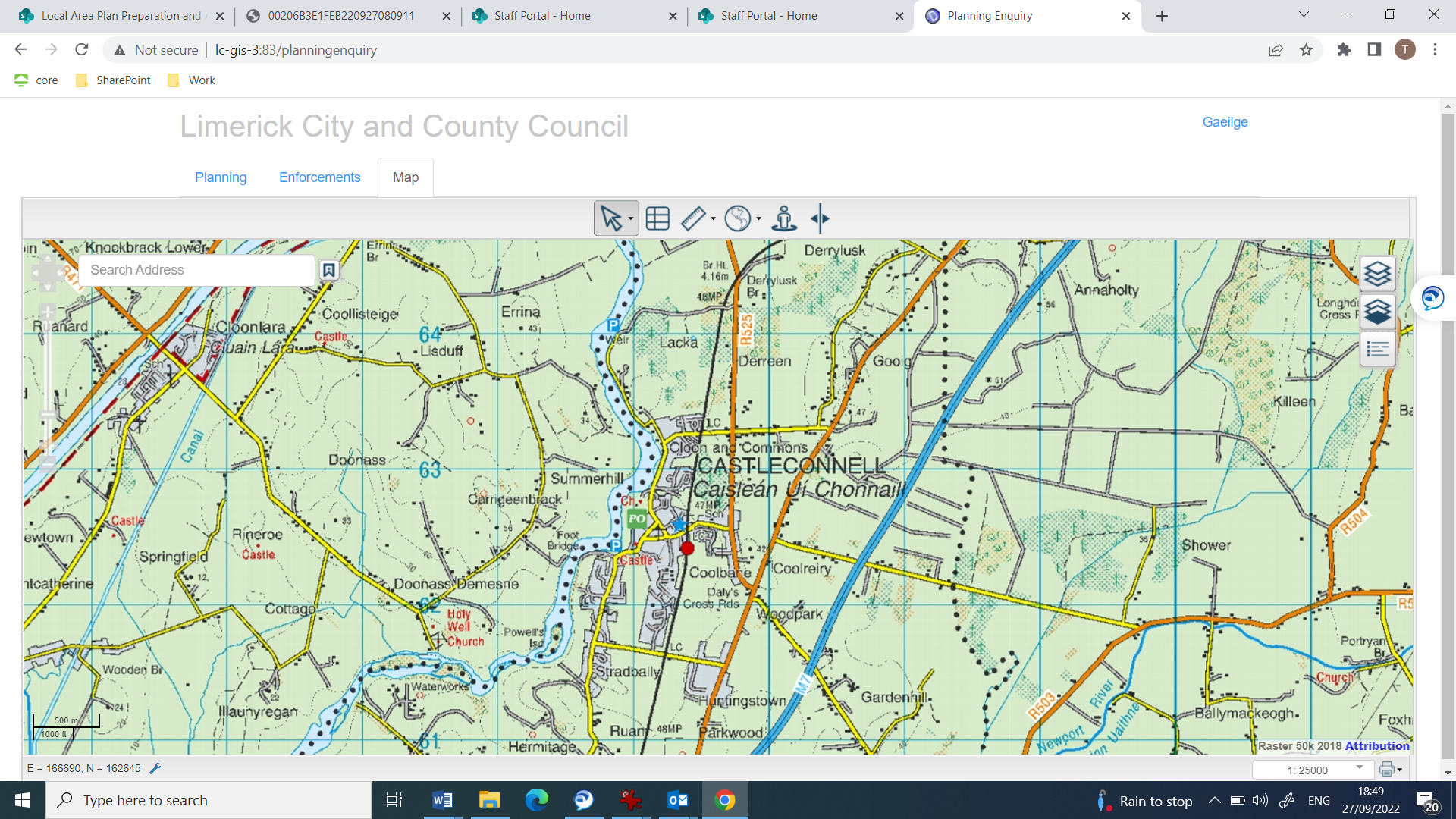
Figure 1: Castleconnell village located on the banks of the River
The European Directive 2007/60/EC provides the overarching European legalisation, in relation to managing flood risk, it seeks to reduce and manage the risks that flooding pose to humans, the environment, cultural heritage and the environment. The legalisation applies to both inland and coastal water sources and requires EU states to:
- Carry out a preliminary assessment in order to identify the river basins and associated coastal areas, where potential significant flood risk exists;
- Prepare flood extent maps for the identified areas;
- Prepare flood risk management plans focused on prevention, protection and preparedness. These plans are to include measures to reduce the probability of flooding and its potential consequences.
Implementation of the EU Floods Directive is required to be coordinated with the requirements of the EU Water Framework Directive and the current National River Basin Management Plan.
In line with evolving European legalisation and evolving national legalisation, the government in 2004 established a Flood Policy Review Group and carried out an interdepartmental review of national flood risk management policy and approved a Flood Policy Review Report. The recommendations of the Report included appointment of the OPW as lead agency for co-ordinating delivery of flood risk management policy. The OPW carries out this role by co-ordinating the implementation of flood risk management policy and measures across three strategic areas:
- Prevention - avoiding construction in flood-prone areas;
- Protection - taking feasible measures to protect areas against flooding.
- Preparedness - planning and responding to reduce the impacts of flood events.
The review also identified a number of key measures for implementation in relation to flood risk management, most relevant to plan preparation is the "Planning System and Flood Risk Management Guidelines” published in 2009, which provide guidance to Local Authorities on plan formulation and decision making in areas at risk of flooding. The review also resulted in an enhancement to availability of data on flood risk and reporting on flood events, which assists in decision making in relation to land use planning.
2.2.1 National CFRAM Programme
The OPW undertook the National Catchment-based Flood Risk Assessment and Management (CFRAM) Programme in consultation with the Local Authorities and supported by external engineering consultants. The objectives of the CFRAM Programme was to:
- Identify and map the existing and potential future flood hazard and flood risk in the areas at potentially significant risk from flooding, called Areas for Further Assessment (AFAs);
- identify feasible structural and non-structural measures to effectively manage the assessed risk in each of the AFAs, and
- Prepare a set of Flood Risk Management Plans, and associated Strategic Environmental and Habitats Directive (Appropriate)Assessment, that set out the proposed feasible measures and actions to manage the flood risk in these areas and their river catchments.
The Programme is being implemented through CFRAM studies that have been undertaken for each of the river basin districts in Ireland. The CFRAM Programme comprises three phases as follows:
- The Preliminary Flood Risk Assessment (PFRA) mapping exercise, which was completed in 2012;
- The CFRAM Studies and parallel activities, with Flood Risk Management Plans and
- Implementation and Review.
The CFRAM programme has provided invaluable background information in relation to flooding throughout Ireland and is invaluable in terms of plan formulation. These maps have recently been updated with the National Indicative Fluvial Mapping and National Coastal Flood Hazard Mapping and probabilistic and historical ground water flood maps prepared by the Geological Survey of Ireland.
2.2.2 Flood Risk Management Guidelines
In 2009, the OPW and the Department of the Environment and Local Government (DEHLG) published Guidelines on flood risk management for Planning Authorities - The Planning System and Flood Risk Management - Guidelines for Planning Authorities. These Guidelines seek to establish a regime to assist with flood risk identification, assessment and management and embed this into the planning process.
The core objectives of the Guidelines are to:
- Avoid inappropriate development in areas at risk of flooding;
- Avoid new developments increasing flood risk elsewhere, including that which may arise from surface water run-off;
- Ensure effective management of residual risks for development permitted in floodplains;
- Avoid unnecessary restriction of national, regional or local economic and social growth;
- Improve the understanding of flood risk among relevant stakeholders; and
- Ensure that the requirements of EU and national law in relation to the natural environment and nature conservation are complied with at all stages of flood risk management.
The Guidelines follow the principle that development should not be permitted in flood risk areas, particularly floodplains, except where there are no alternative and appropriate sites available in lower risk areas that are consistent with the objectives of proper planning and sustainable development.
One of the key areas identified in the Flood Guidelines is around identifying flood risk, which is an expression of the combination of the flood probability or likelihood and the magnitude of the potential consequences of the flood event. It is normally expressed in terms of the following relationship:
Flood risk = Likelihood of flooding x Consequences of flooding
Likelihood of flooding is normally defined as the percentage probability of a flood of a given magnitude or severity occurring or being exceeded in any given year.
Consequences of flooding depend on the hazards associated with the flooding (e.g. depth of water, speed of flow, rate of onset, duration, wave-action effects, water quality) and the vulnerability of people, property and the environment potentially affected by a flood (e.g. the age profile of the population, the type of development and the presence and reliability of mitigation measures).
Flood zones are geographical areas within which the likelihood of flooding is in a particular range and they are a key tool in flood risk management within the planning process as well as in flood warning and emergency planning.
There are three types of flood zones defined for the purposes of the Flood Guidelines:
- Flood Zone A – where the probability of flooding from rivers and the sea is highest (greater than 1% or 1 in 100 for river flooding or 0.5% or 1 in 200 for coastal flooding);
- Flood Zone B – where the probability of flooding from rivers and the sea is moderate (between 0.1% or 1 in 1000 and 1% or 1 in 100 for river flooding and between 0.1% or 1 in 1000 year and 0.5% or 1 in 200 for coastal flooding); and
- Flood Zone C – where the probability of flooding from rivers and the sea is low (less than 0.1% or 1 in 1000 for both river and coastal flooding).
Flood Zone C covers all other areas that are not in zones A or B
3.1 Introduction – Stage 1 Flood Risk Identification
Flood risk identification was undertaken in order to identify whether there may be any flooding or surface water management issues within or adjacent to zoned lands and consequently whether Stage 2 SFRA (flood risk assessment) should be proceeded to. Stage 1 SFRA is based on existing information on flood risk indicators based on available flood detail.
In Castleconnell, the River Shannon forms the western boundary of the village and tributaries of the River Shannon, such as the channel, which enters the river at Ferrybank, run though the village.
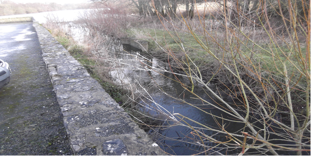
Figure 2: Channel entering the river at Ferrybank
Such tributary streams and channels extend throughout the plan area. Some of these are entirely artificial, while others have been heavily modified. All of them are designed to convey water as quickly as possible to the River Shannon. Given the rate of flow in the river during flood conditions, Castleconnell is susceptible to fluvial flood risk. Castleconnell and the surrounding area was badly flooded most recently in 2009, 2015 and 2020, following periods of prolonged rainfall. The rise in water levels in the main river channel has the effects of backing up those tributaries in the plan area which drain into it and this contributes further to local flood risk within the plan boundaries.
CFRAMS provides for project-level development and assessment of a Flood Relief Scheme for Castleconnell, including environmental assessment as necessary and further public consultation, for refinement and preparation for planning / exhibition and, if and as appropriate, implementation. The potential measure would protect at-risk properties against the 1% AEP Fluvial flood event by a combination of flood defences, improved channel conveyance and other works. Limerick City and County Council in conjunction with OPW have engaged consultants to progress a flood relief scheme for Castleconnell.
To date, significant quantities of data has been gathered which has provided valuable insight into previous flooding mechanisms and issues throughout Castleconnell. As part of the development of the flood relief scheme, the project team reviewed a number of previous flood events (including 2009, 2015 and 2020) within Castleconnell in order to develop a detailed understanding of the relevant flood mechanisms throughout the scheme area. In particular, the flood event that occurred in February 2020 has been important in calibrating the 2D hydraulic model to accurately represent flooding in Castleconnell.
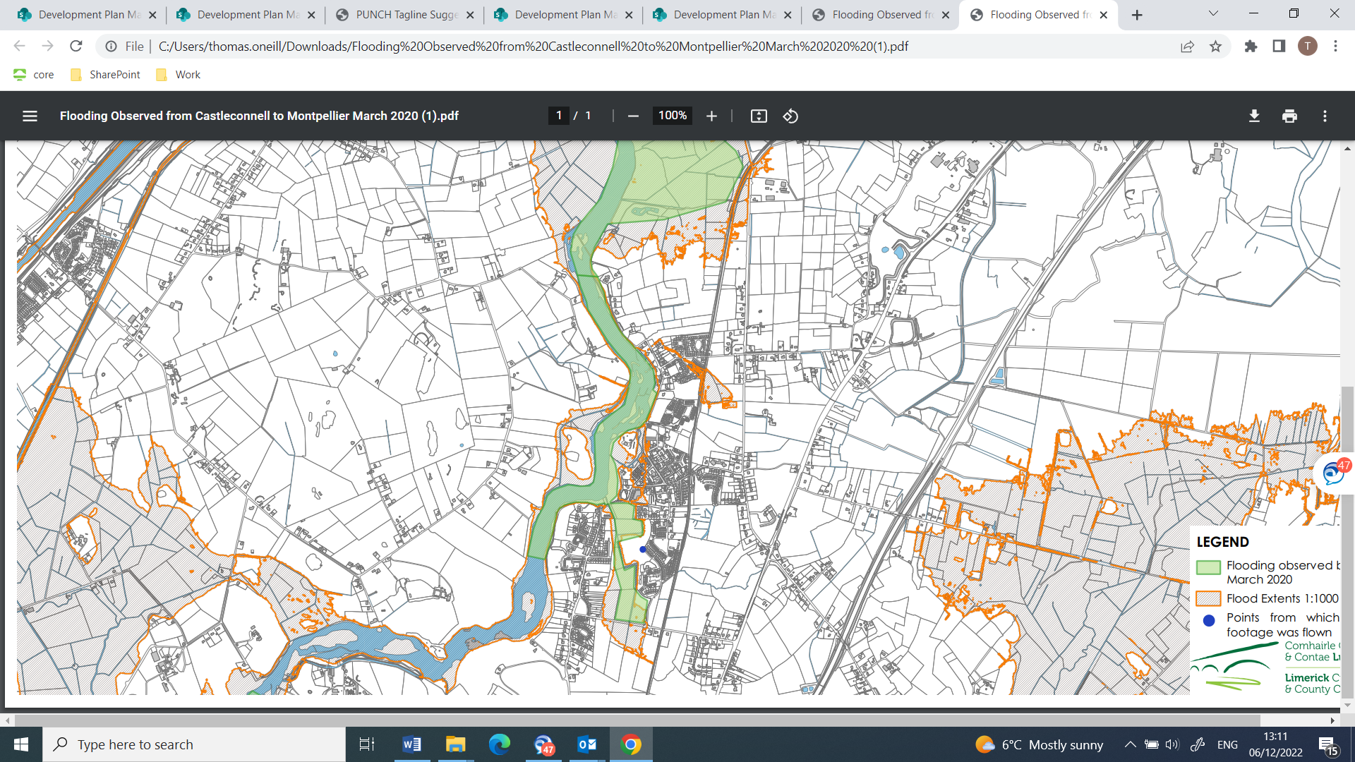
Figure 3: Maps produced from Drone footage showing the extent of flooding in March 2020
In 2009, major flooding took place in Castleconnell. Approximately 70 houses were affected by flooding. The majority of these houses were located in the western portion of the plan area, close to the existing village centre. These are located to the east, south east and Further flooding took place in 2015 and in 2020, where infrastructure, such as roads were rendered impassable in Castleconnell village, south of the castle ruins. Commercial properties to the east, southeast and south of the castle ruins have been flooded. The health care centre southeast of the castle ruins was also flooded as was the pumping station north of the castle ruins. All of these are considered to be of high vulnerability risk.
Additional flooding events had taken place in 1990, so over a 30-year period at least four significant flood events had taken place in the village.
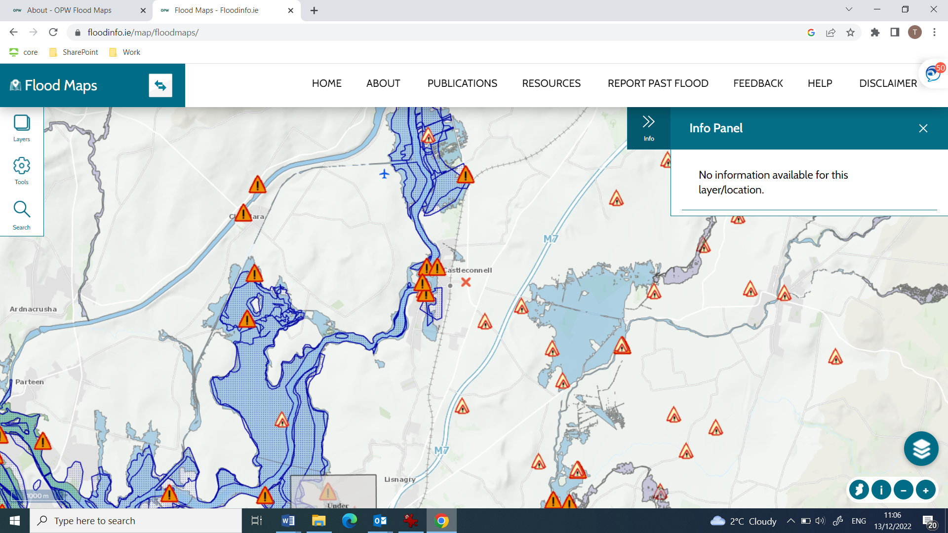
Figure 4: Taken from www.floodinfo.ie, this shows the concentration of Flood events in Castleconnell
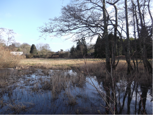
Figure 5: High water levels close to Ferrybank, following heavy rain in early 2018.
3.3 Conclusion of Stage 1 SFRA
The information detailed above indicates elevated levels of flood risk in various locations across the Plan area; therefore, a Stage 2 SFRA has been proceeded to.
4.0 Stage 2 Strategic Flood Risk Assessment
Introduction
Stage 2 SFRA is being undertaken to:
- Confirm the sources of flooding that may affect zoned and adjacent areas;
- Appraise the adequacy of existing information as identified by the Stage 1 SFRA; and
- Scope the extent of the risk of flooding through the preparation of a Flood Zone Map.
4.1 Assessment of information outlined above and Delineation of Flood Zones
In order to inform the Stage 2 assessment, the village of Castleconnell was inspected, which involved numerous site visits in order to examine, the potential source and direction of flood paths from fluvial sources, locations of topographic features that coincide with the flood boundaries and to identify vegetation associated with a high frequency of flood inundation. As the preparation of this report is coinciding with the preparation of the flood relief scheme for Castleconnell, various studies being carried out to support the scheme, has assisted in informing this report and has informed the zoning decisions in the Draft Local Area Plan.
Three factors influence the zoning decisions in relation to these areas. The first is the existence of the flood risk as presented by the CFRAM flood maps (see Figure 6 below) and discussions with Local Authority personnel, the second is the low-lying nature of the lands and history of flood risk. The six inch map series indicates regular drainage features identifying the potential for water logging. It was noted that streams run through part of this area, and some of them had been straightened and deepened to increase their conveyance capacity. The third factor to be considered is the core strategy that informs the Draft Plan. The Core Strategy Figures set out in Table 3.1 of the draft plan indicates that 15.0 ha is required for residentially zoned land. This is less than in the existing plan. In accordance with the Flood Guidelines for Planning Authorities, it is not considered appropriate to zone lands at risk of flooding. The reduction in zoned lands will also lead to a potential increase in lands, which have permeable, i.e. undeveloped surfaces within and close to the plan area, which would help manage surface water runoff, which is a factor to consider in flood risk management.
Discussions regarding drainage and flooding issues took place with Local Authority personnel, which indicated the vulnerability of Castleconnell to flooding and specific locations, which have been vulnerable to flood risk in the past and the need for progress in terms of the development and implementation of a Flood Relief Scheme in Castleconnell. The flood maps have informed the new zoning extent so that in these areas zoning is for uses compatible with flood risk, such as open space or amenity uses or agricultural uses. As noted above, much the Special Control Area is also subject to flood risk and this zoning pattern is also compatible with the relevant flood risk. This approach to zoning has evolved in the preparation of the plan, considering submission received to date and also as a result of analysis being carried out to support the Castleconnell Flood Relief Scheme.
Hydrology and hydraulics tasks are currently being finalised with the final reports to be published in the coming weeks. To facilitate this, a number of surveys including (but not limited to); topographic surveys, drainage (including CCTV) have been undertaken over the course of the project to gather a detailed understanding of flood risk in Castleconnell. This study has included a detailed review of all relevant watercourses and tributaries, which flow into and potentially affect Castleconnell with the main outputs consisting of predicted flood extents mapping for the design events, namely the Cedarwood Stream.
As a result of this work, it is considered that the 2009 flood event was of a similar magnitude to a 1% Annual Exceedance Event (AEP) also known as the 1 in 100-year event. The proposed scheme will be designed to protect against a 1 in 100-year event and will also take appropriate account of the unique flow conditions that are experienced in Castleconnell downstream of Parteen Weir.
The Flood Relief Scheme is currently in the options appraisal phase. The project team have considered an extensive list of potential flood management measures, including flood walls, embankments, road raising, demountable barriers, river restoration and maintenance works, flow diversion, storage and more. Each of these measures have been assessed by technical, social, environmental or economic criteria. From this appraisal, three options are being brought forward to the pubic consultation stage for a more detailed assessment.
4.2 Flooding from Other Sources
While pluvial flood risk has not featured to great degree in flood risk assessment in the village, due to the far greater effects from fluvial flooding posed by the River Shannon, it is often the case in modern developed areas that it can have local effects. To date much development has not tended to rely on attenuation or nature friendly measures to try and control water flow and run off and local rain fall events can generate considerable volumes of water. In submissions to other plans and in the PFRA for Castleconnell, the OPW draws attention to the importance of local factors in determining flood risk and possible movement and in built up areas this is an important element.
In Castleconnell there has been significant development in the last twenty years which has altered local ground conditions. Even where open space occurs in developments where impermeable surfaces might not exist, the effects of the passage of construction traffic and machinery have often compacted soil and subsoil, which would diminish, waters ability to infiltrate through the soil. This has occurred in the plan area, where an increase in impermeable surfaces and soil compaction has resulted in increased water flow to the local watercourse and hence to the River Shannon. One watercourse would serve as an example, the Stradbally East stream (FRA, 2019 submitted with planning application 19/518). This is now heavily modified and is a straightened and deepened drain. This does increase its conveyance capacity but its original function was to convey water from agricultural land and now forms the boundary of a developed residential site.
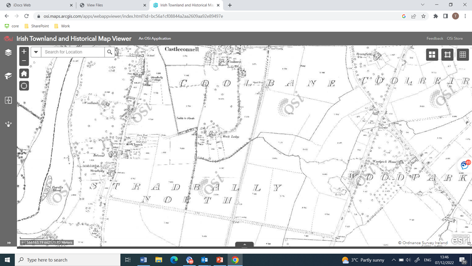
Figure 6: The red arrow indicates the east Stradbally Stream on the 25-inch maps dating from c.1900
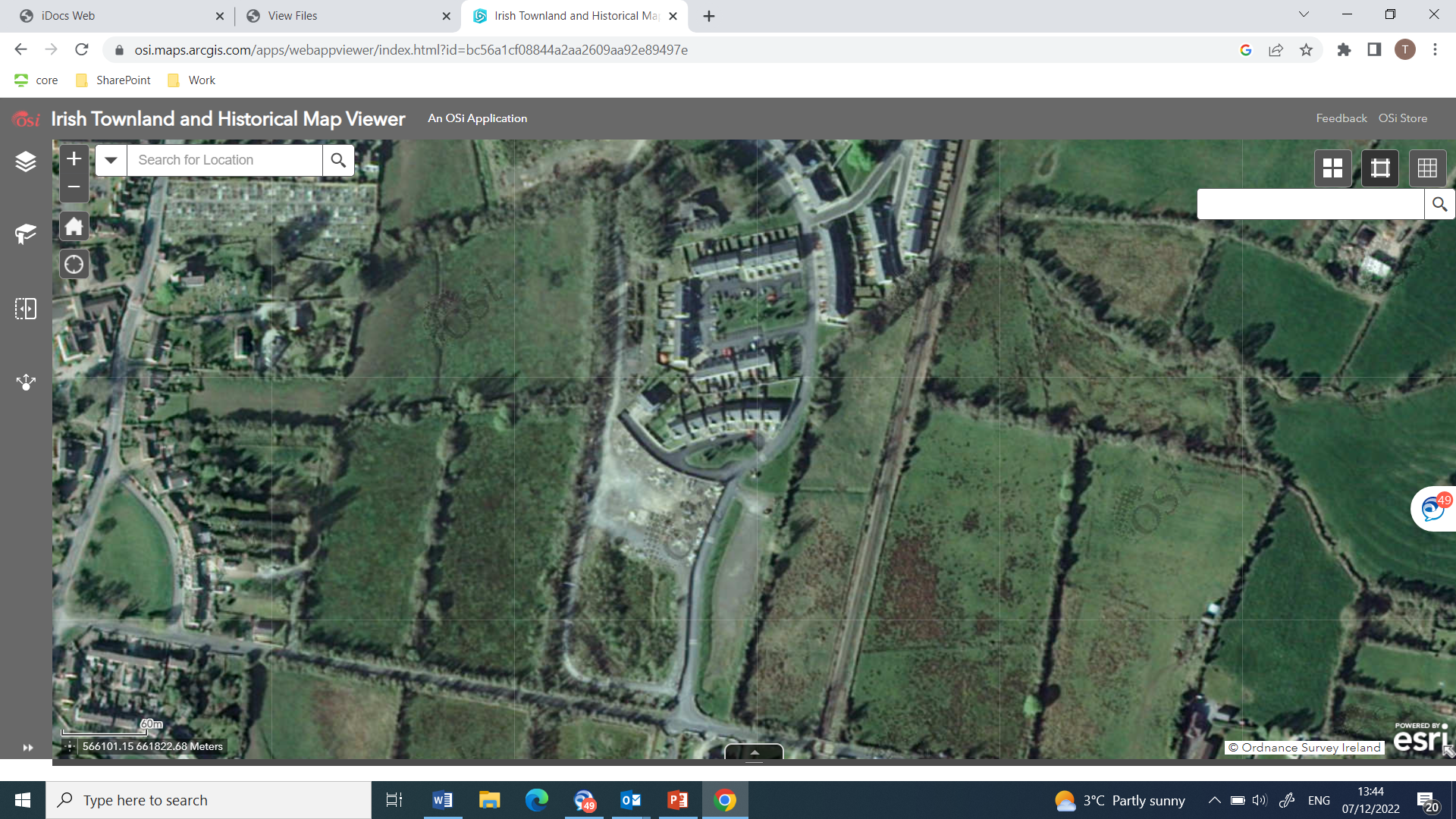
Figure 7: Taken in 2005 this picture shows Castle Rock under construction, and the red arrow shows the watercourse. It now absorbs run off at a rate greater than that associated with the previous agricultural usage
From the above it can be seen that local changes in development patterns and intensification of land usage can have an effects on over land flow and surface water movement in particular. This can exacerbated when the drainage of these tributaries to the River Shannon is impeded by high water levels in the main channel when the river is in flood. This is a factor that is being borne in mind in Castleconnell in the plan and has been reflected in the insertion of policies, which promote nature based solutions and Sustainable Urban Drainage (SuDs). This is dealt with further in Section 3.4 below.
Soil types around Castleconnell tend to be poorly drained. These vary from mineral soils (podzolics) to peat in the northern most part of the plan area. Gleys are present in the southern part of the plan area. All of these would have impeded drainage characteristics and as a result would not have a great deal of absorption capacity. Shown below is the winter 2015/16 surface waterflooding map, which reinforces that point.
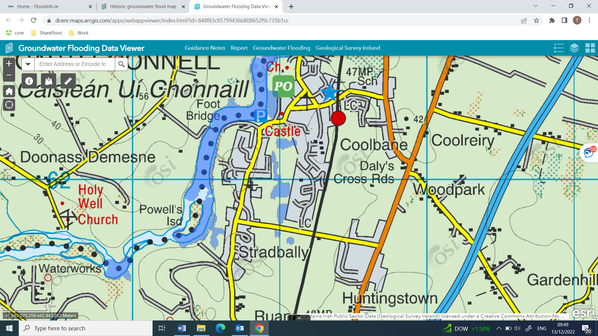
Figure 8: Locations of 2015/2016 surface water flooding in Castleconnell. Source: GSI website.
In 2010, the OPW financed the construction of impermeable earthen embankment and associated works at rear of Meadow Brooke Estate/ Purchased of temporary booms and pumps /Placement of a sluice onto the bridge culvert at Island House (OPW, Flood Risk Management Plan County Summary). These measures have assisted in dealing with flood events in Castleconnell, however, the requirement remains for a designed flood relief scheme. The Flood Relief Scheme will consist of one or a combination of flood risk management measures: Floodwalls, Embankments, Road Raising, and Barriers. These have been presented to the public in consultation meetings in September of 2022 and their responses are currently being appraised. 4.4 Flood Risk Zone Mapping
A Flood Risk Map has been produced taking into account the findings of the Stage 1 and Stage 2 SFRA as detailed above. The map is illustrated below identifies Flood Zone A (darker blue) and Flood Zone B4 (lighter blue). As per the Guidelines, the flood zones in Castleconnell are as follows:
- Flood Zone A – where the probability of flooding from the River Shannon and its tributaries is highest (greater than 1% or 1 in 100 for river flooding);
- Flood Zone B – where the probability of flooding from the River Shannon and its tributaries is moderate (between 0.1% or 1 in 1000 and 1% or 1 in 100 for river flooding); and;
- Flood Zone C – where the probability of flooding from the River Shannon and its tributaries is low (less than 0.1% or 1 in 1000 for river flooding).
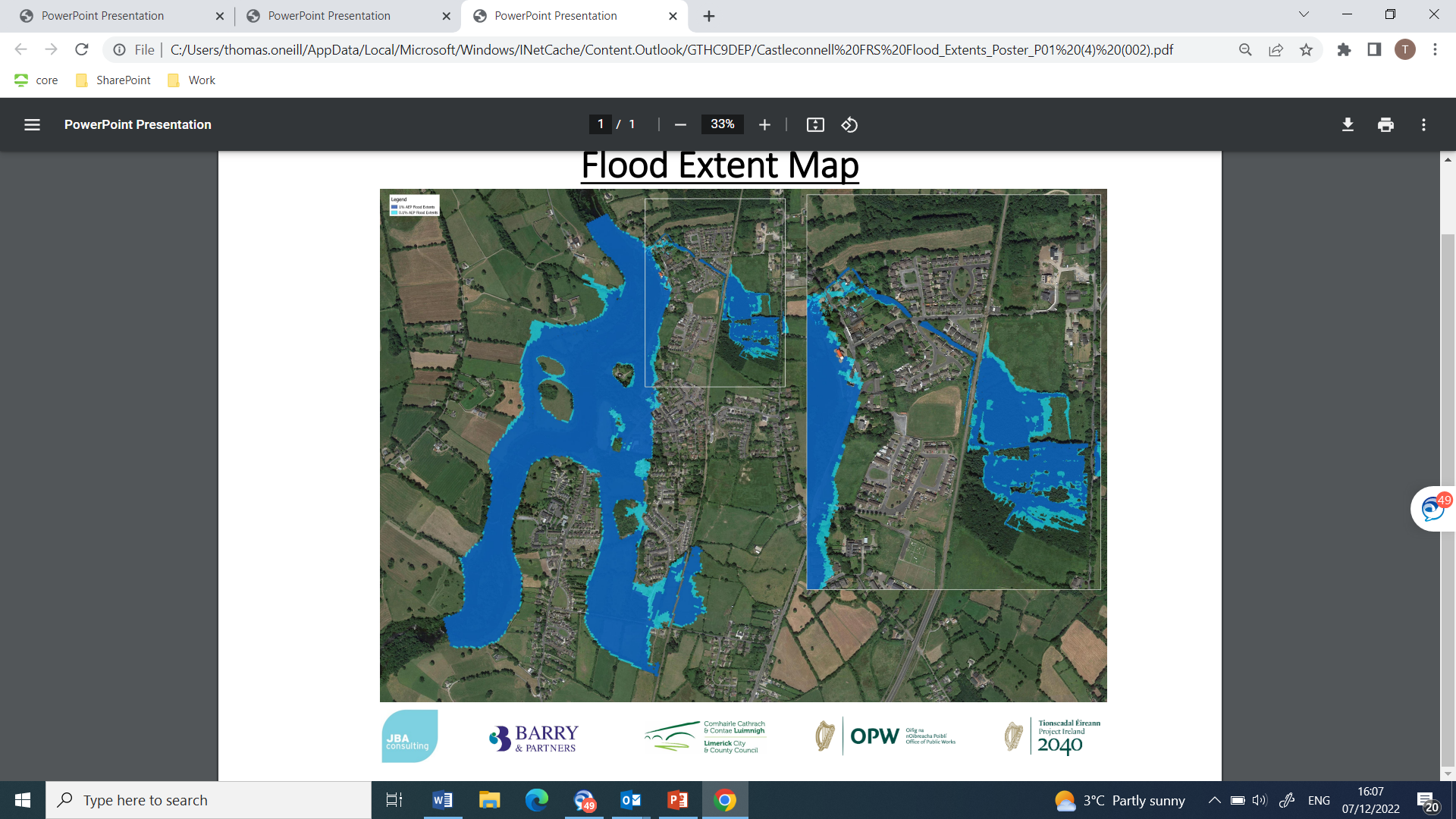
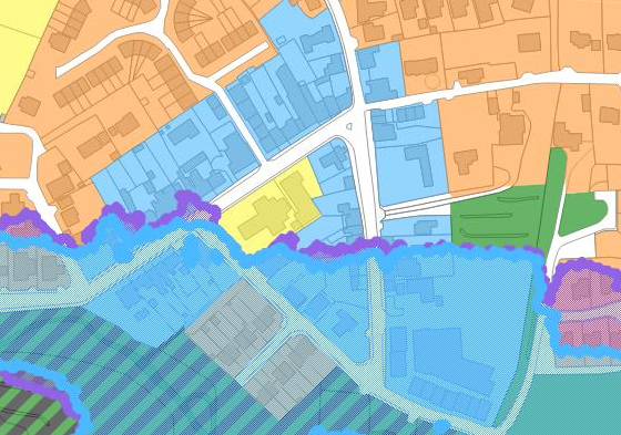
Figure 9: Flood extent in Castleconnell. Dark blue shows areas with 1:100 flood risk, while the light blue shows 1:1000.
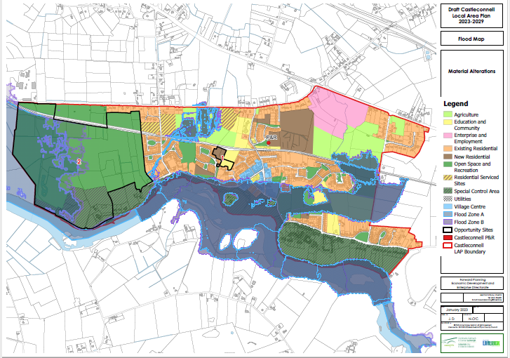
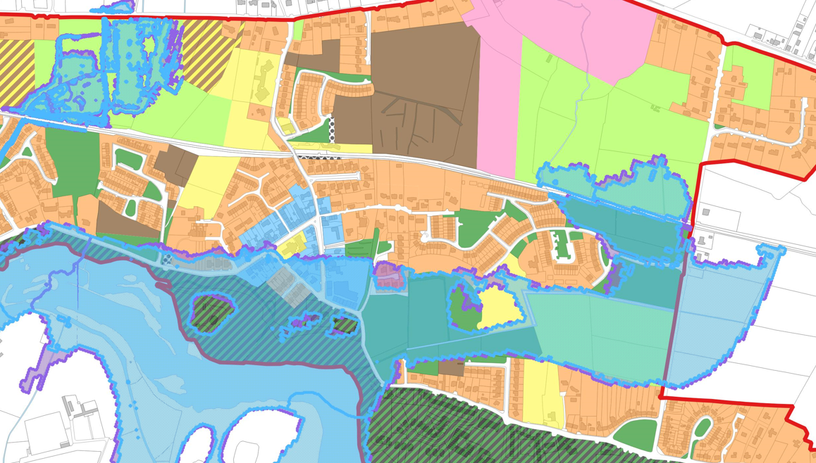
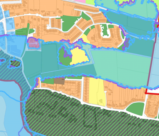
Figure 10: Zoning Map and Flood Extents in Castleconnell
4.5 Climate change considerations
The Planning System and Flood Risk Management Guidelines for Planning Authorities and Technical Appendices, 2009 recommends that a precautionary approach to climate change is adopted due to the level of uncertainty involved in the potential effects. In this regard, the Guidelines recommends:
- Recognising that significant changes in the flood extent may result from an increase in rainfall or tide events and accordingly adopting a cautious approach to zoning land in these potential transitional areas;
- Ensuring that the levels of structures designed to protect against flooding such as flood defences, land raising or raised floor levels are sufficient to cope with the effects of climate change over the lifetime of the development they are designed to protect (normally 85-100 years); and
- Ensuring that structures to protect against flooding and the development protected are capable of adaptation to the effects of climate change when there is more certainty about the effects and still time for such adaptation to be effective
Advice on the expected impacts of climate change and the allowances to be provided for future flood risk management in Ireland is given in the OPW Draft Guidance on Assessment of Potential Future Scenarios for Flood Risk Management (2009). Two climate change scenarios are considered. These are the Mid-Range Future Scenario (MRFS) and the High-End Future Scenario (HEFS). The MRFS is intended to represent a "likely" future scenario based on the wide range of future predictions available. The HEFS represents an”extreme" future scenario at the upper boundaries of future projections. The mapping provided in the SFRA Flood Zones A and B have been informed by the OPW’s CFRAMS Present-Day Scenario.
In addition to considering climate change factors in the SFRA, the Council have embedded the principles of Sustainable Urban Drainage Systems (SuDS) and Nature Based Solutions (NBS) into the Local Area Plan, which not only has climate benefits, but also a range of environmental benefits to support the delivery of sustainable development. The approach taken in the proposed Local Area Plan, in line with the recently adopted Limerick Development Plan 2022 – 2028, which seeks to adopt SuDS and nature based solutions as the best practice approach, not just on key development sites. The Council will work with developers to promote SuDS and nature based solutions on a case-by-case basis and tailor solutions to the specific sites. In Chapter 5 of the Plan, Table 4 Public Realm Open Space Provision in Residential Developments in Castleconnell, outlines the requirement to provide new spaces as part of developments. Though part of standard planning practice, the requirement for minimum open space provision will ensure new permeable surfaces within new developments.
Similarly, Section 9.2 of the Plan Surface Water Management and SuDS will ensure the adoption of nature friendly solutions to the issue of surface water management. The contents of the publication Nature-based Solutions to the Management of Rainwater and Surface Water Runoff in Urban Areas Water Sensitive Urban Design Best Practice Interim Guidance Document, will be very useful in this regard.
The approach taken in the proposed Local Area Plan, in line with the recently adopted Limerick Development Plan 2022 – 2028, is to seek to adopt SuDS and nature based solutions as appropriate not just on key development sites. The Council will work with developers to promote SuDS and nature based solutions on a case-by-case basis and tailor solutions to the specific sites.
Recommendations and Integration with Local Area Plan
In order to comply with The Planning System and Flood Risk Management - Guidelines for Planning Authorities and Department of the Environment, Community and Local Government Circular (PL 2/2014) and contribute towards flood risk management within the Plan area, the recommendations below have been made by the SFRA process.
- Previously undeveloped lands within Zones A or B should not be zoned for incompatible uses, unless a Justification Test is passed (including a planning conclusion that there are no alternative locations available for accommodating such uses). With respect to previously developed lands, the potential conflict between zonings and highly vulnerable development will be avoided by applying a limiting land use policy approach, as outlined in Objective IU O5 shall be applied on these lands. Full details of all flood justification tests are included in Appendix 1.
- Incorporate policies and objectives to manage surface water in line with Sustainable Urban Drainage Systems and nature-based solutions.
5.2 Integration of provisions of Flood Risk Assessment and Flood Management into the Local Area Plan
In the formulation of the Local Area Plan to date, the Council have sought to ensure that appropriate integration of the recommendation of the Strategic Flood Risk Assessment for the Draft Castleconnell Local Area Plan has taken place, in order to comply with the Flood Guidelines and the proper planning and sustainable development of the area. Objectives as follows are critical to complying with the relevant legalisation:
- Objective IU O5 – Flood Risk Management – which seeks to comply with the Flood Guidelines and Circular PL2/2014, it also seeks to cooperate with the OPW in delivery of the flood relief scheme and to safeguard access to drainage channels;
- Objective IU O4 – Surface Water Management and SuDS – which relates directly to surface water management and protecting, surface water resources.
Coupled with key policies and objectives in the Limerick Development Plan 2022 – 2028, which are as follows:
- Policy CAF P5 – Managing Flood Risk - It is a policy of the Council to protect Flood Zone A and Flood Zone B from inappropriate development and direct developments/land uses into the appropriate lands, in accordance with The Planning System and Flood Risk Management Guidelines for Planning Authorities 2009 (or any subsequent document) and the guidance contained in Development Management Standards and the Strategic Flood Risk Assessment (SFRA).
- Objective CAF O20 – Flood Risk Assessments – It is an objective of the Council to require a Site-Specific Flood Risk Assessment (FRA) for all planning applications in Flood Zones A and B and consider all sources of flooding (for example coastal/tidal, fluvial, pluvial or groundwater), where deemed necessary.
- Objective IN O12 – Surface Water and SuDS – The Development Plan sets out that there are many approaches to management of surface water that take account of water quantity (flooding), water quality (pollution), biodiversity (wildlife and plants) and amenity and these are collectively referred to as Sustainable Urban Drainage Systems (SuDS). The use of SuDS to address surface water and its diversion from combined sewers is encouraged, in particular, in infill/brownfield sites and higher density areas as appropriate.
It is considered that the approach outlined above and the policies and objectives of the Limerick Development Plan and the Draft Castleconnell Local Area Plan provide a robust approach to support the Plan making process.
Stage 2 SFRA has been undertaken as part of the Plan-preparation process and the SFRA has informed the preparation of the Plan. The SFRA has mapped boundaries identifying areas at risk of flooding, taking into account many factors to determine the extent of flooding. In the preparation of this Local Area Plan, significant rationalisation of the zoning pattern has been carried out, the Council have, in so far as possible sought to avoid zoning of lands at flood risk or have zoned lands for water compatible uses. The Council have also sought to incorporate nature based solutions and blue green infrastructure measures into the plan, as a means of dealing with surface water, while also benefitting climate action. The Council, in conjunction with the OPW are currently developing a flood relief scheme for the village of Castleconnell, which will seek to safeguard the village from flood risk.
Appendix I - Flood Justification Tests
As per Section 4.2 of Flood Guidelines, Flood Justification Tests has been undertaken for lands zoned in the Draft LAP, which are identified as liable to flooding, according to the most up to date flooding maps available. These lands are in the main are developed or unsuitable for development and where unsuitable for development have been zoned for purpose of agricultural use, Special Control Area or Open Space and Recreation, which will generally only permit water compatible uses.
- Lands located in the village core zoned Village Centre
|
1
|
The urban settlements is identified for growth under the National Planning Framework, Regional Economic and Spatial Strategy, statutory plans prepared under the Planning and Development Act 2000 as amended, relevant Directives and the Planning Guidelines. |
|
|
Castleconnell is a Level 3 Settlement in the settlement hierarchy, identified in the Limerick Development Plan 2022 – 2028. The Limerick Development Plan promotes Level 3 settlements, as development centres for population growth sustaining a wide range of functions, services and employment opportunities supporting its hinterland. In line with National Policy Objective 3c, 30% of all new homes targeted within Level 3 settlements shall be within the existing built-up area of the village. Part of the lands within the village centre, are identified as being risk as flooding, however, the lands are predominantly developed and also form the core of the village and in line with national, regional and local planning policy critical to the overall development of the village centre, will facilitate consolidation and by in large is brown field or infill lands.
|
||
|
2
|
The zoning or designation of the lands for the particular use or development type is required to achieve the proper planning and sustainable development of the town and in particular: |
|
|
(i) Is essential to facilitate regeneration and/or expansion of the centre of the urban settlement |
The lands are zoned village centre, reflecting their existing uses. The lands are essential to facilitate regeneration and expansion of the centre of the settlement. |
|
|
(ii) Comprises significant previously developed and/or under-utilised lands |
These lands are already developed and currently occupied by existing uses as per their proposed zoning objective. |
|
|
(iii) Is within or adjoining the core of an established or designated urban settlement |
The lands are zoned village centre and located in the core of the village. |
|
|
(iv) Will be essential in achieving compact or sustainable urban growth |
The redevelopment on these lands will contribute to compact urban growth aligned to higher-level spatial policy. |
|
|
(v) There are no suitable alternative lands for the particular use or development type, in areas at lower risk of flooding within or adjoining the core of the urban settlement |
The lands are currently developed. |
|
|
3 |
A flood risk assessment to an appropriate level of detail has been carried out as part of the Strategic Environmental Assessment as part of the local area plan preparation process, which demonstrates that flood risk to the development can be adequately managed and the use or development of the lands will not cause unacceptable adverse impacts elsewhere. |
The extent of Flood Zone A/B across the village centre zoning is limited and risks can be managed by following the sequential approach, guided by an appropriately site specific flood risk assessments.
|
|
4 |
Conclusion of the Justification Test |
|
|
Given the measures above, the objectives of the Draft LAP, the Planning Authority is satisfied that the proposed zoning of these lands as village centre for development is appropriate subject to more detailed site-specific flood risk assessment to be submitted as supplementary information with planning applications on these lands, |
||
|
|
||
- Existing Residential
|
1
|
The urban settlements is identified for growth under the National Planning Framework, Regional Economic and Spatial Strategy, statutory plans prepared under the Planning and Development Act 2000 as amended, relevant Directives and the Planning Guidelines. |
|
|
Castleconnell is a Level 3 Settlement in the settlement hierarchy, identified in the Limerick Development Plan 2022 – 2028. The Limerick Development Plan promotes Level 3 settlements, as development centres for population growth sustaining a wide range of functions, services and employment opportunities supporting its hinterland. In line with National Policy Objective 3c, 30% of all new homes targeted within Level 3 settlements shall be within the existing built-up area of the village. Part of the lands within the settlement are zoned existing residential and are identified as being risk as flooding, however, the lands are also close to the core of the village and in line with national, regional and local planning policy critical to the overall development of the village centre, will facilitate consolidation and by in large is brown field or infill lands.
|
||
|
2
|
The zoning or designation of the lands for the particular use or development type is required to achieve the proper planning and sustainable development of the town and in particular: |
|
|
(i) Is essential to facilitate regeneration and/or expansion of the centre of the urban settlement |
The lands are already developed and the zoning reflects their existing uses. They are a reflection of the development of the village. Given the emphasis of the NPF and the RSES on the use of existing development sites, these areas are essential to the viability of the settlement. |
|
|
(ii) Comprises significant previously developed and/or under-utilised lands |
These lands are already developed and currently occupied by existing uses as per their proposed zoning objective. |
|
|
(iii) Is within or adjoining the core of an established or designated urban settlement |
The lands are existing residential and located in the within the development boundary of the plan. |
|
|
(iv) Will be essential in achieving compact or sustainable urban growth |
The redevelopment on these lands will contribute to compact urban growth aligned to higher-level spatial policy. |
|
|
(v) There are no suitable alternative lands for the particular use or development type, in areas at lower risk of flooding within or adjoining the core of the urban settlement |
The lands are currently developed. |
|
|
3 |
A flood risk assessment to an appropriate level of detail has been carried out as part of the Strategic Environmental Assessment as part of the local area plan preparation process, which demonstrates that flood risk to the development can be adequately managed and the use or development of the lands will not cause unacceptable adverse impacts elsewhere. |
The extent of Flood Zone A/B across much of this zoning is limited and risks can be managed by limiting development to minor developments in areas that are at risk of flooding as per Section 5.28 of the Flood Guidelines and in line with Circular PL 2/2014. |
|
4 |
Conclusion of the Justification Test |
|
|
Given the measures above, the objectives of the Draft LAP, the Planning Authority is satisfied that the proposed zoning of these lands as existing residential for development is appropriate subject to the provisions of Section 5.28 of the Planning and Flood Risk Guidance and in line with Circular PL 2/2014. |
||
- Lands adjoining the River Shannon zoned Special Control Area
|
1
|
The urban settlements is identified for growth under the National Planning Framework, Regional Economic and Spatial Strategy, statutory plans prepared under the Planning and Development Act 2000 as amended, relevant Directives and the Planning Guidelines. |
|
|
Castleconnell is a Level 3 Settlement in the settlement hierarchy, identified in the Limerick Development Plan 2022 – 2028. The Limerick Development Plan promotes Level 3 settlements, as development centres for population growth sustaining a wide range of functions, services and employment opportunities supporting its hinterland. In line with National Policy Objective 3c, 30% of all new homes targeted within Level 3 settlements shall be within the existing built-up area of the village. Castleconnell is situated adjoining the River Shannon and has an associated Natura 2000 designation, which is the Lower River Shannon Special Area of Conservation and the lands immediately adjoining the river are at risk of flooding and zoning is in place to safeguard the designated site.
|
||
|
2
|
The zoning or designation of the lands for the particular use or development type is required to achieve the proper planning and sustainable development of the town and in particular: |
|
|
(i) Is essential to facilitate regeneration and/or expansion of the centre of the urban settlement |
The lands are zoned Special Control Area, having regard to the sensitivities of the lands adjoining the nature designation and to safeguard the river from development, which may affect the designation. These lands, are located on the edge of the settlement, but are important as part of the setting of the Village and because of the sensitivities of the River Shannon, which is designated as an Special Area of Conservation at this point. Limited development is considered open for consideration in this zoning, such as ancillary leisure or tourism, any such development would be subject an appropriate level of flood risk assessment and environmental assessment. Development in this area would be restricted to water compatible development. |
|
|
(ii) Comprises significant previously developed and/or under-utilised lands |
Having regard to the location of the lands and the sensitive nature of the landscape, only development appropriate to its location would be considered, subject to an appropriate level of assessment. |
|
|
(iii) Is within or adjoining the core of an established or designated urban settlement |
The lands are located adjoining the River Shannon and contain some development, future development will be limited to ancillary leisure and tourism development. Development in this area would be restricted to water compatible development. |
|
|
(iv) Will be essential in achieving compact or sustainable urban growth |
The lands are located adjoining the River Shannon and contain some development, future development will be limited to ancillary leisure and tourism development. Development in this area would be restricted to water compatible development |
|
|
(v) There are no suitable alternative lands for the particular use or development type, in areas at lower risk of flooding within or adjoining the core of the urban settlement |
The lands are located adjoining the River Shannon and contain some development, future development will be limited to ancillary leisure and tourism development. Development in this area would be restricted to water compatible development |
|
|
3 |
A flood risk assessment to an appropriate level of detail has been carried out as part of the Strategic Environmental Assessment as part of the local area plan preparation process, which demonstrates that flood risk to the development can be adequately managed and the use or development of the lands will not cause unacceptable adverse impacts elsewhere. |
The lands are located adjoining the River Shannon and contain some development, future development will be limited to ancillary leisure and tourism development. Development in this area would be restricted to water compatible development. |
|
4 |
Conclusion of the Justification Test |
|
|
Given the measures above, the objectives of the Draft LAP, the Planning Authority is satisfied that the proposed zoning of these lands as Special Control Area, would safeguard the designated site and accordingly, development should be limited to water compatible uses. |
||
- Lands zoned Agriculture which is at flood risk within the Plan boundary
|
1
|
The urban settlements is identified for growth under the National Planning Framework, Regional Economic and Spatial Strategy, statutory plans prepared under the Planning and Development Act 2000 as amended, relevant Directives and the Planning Guidelines. |
|
|
Castleconnell is a Level 3 Settlement in the settlement hierarchy, identified in the Limerick Development Plan 2022 – 2028. The Limerick Development Plan promotes Level 3 settlements, as development centres for population growth sustaining a wide range of functions, services and employment opportunities supporting its hinterland. In line with National Policy Objective 3c, 30% of all new homes targeted within Level 3 settlements shall be within the existing built-up area of the village. For the main part lands zoned, which is at risk of flooding, is zoned for non-vulnerable uses for Agricultural purposes.
|
||
|
2
|
The zoning or designation of the lands for the particular use or development type is required to achieve the proper planning and sustainable development of the town and in particular: |
|
|
(i) Is essential to facilitate regeneration and/or expansion of the centre of the urban settlement |
The lands are proposed to be zoned Agriculture and development will be limited in terms of the uses permitted. |
|
|
(ii) Comprises significant previously developed and/or under-utilised lands |
Having regard to the location of the lands, only development appropriate to its location would be considered, subject to an appropriate level of assessment. |
|
|
(iii) Is within or adjoining the core of an established or designated urban settlement |
The lands are located within the Plan boundary. |
|
|
(iv) Will be essential in achieving compact or sustainable urban growth |
Only limited development will be considered, subject to an appropriate level of assessment. |
|
|
(v) There are no suitable alternative lands for the particular use or development type, in areas at lower risk of flooding within or adjoining the core of the urban settlement |
Suitable alternative lands are available for development elsewhere in areas outside of any flood risk. |
|
|
3 |
A flood risk assessment to an appropriate level of detail has been carried out as part of the Strategic Environmental Assessment as part of the local area plan preparation process, which demonstrates that flood risk to the development can be adequately managed and the use or development of the lands will not cause unacceptable adverse impacts elsewhere. |
These lands at flood risk is nearly entirely within Flood Zone A. Applying the sequential approach to flood management means that development within Flood Zones A and B should be avoided. |
|
4 |
Conclusion of the Justification Test |
|
|
Part 2 of the Justification Test has not been passed and the site is at high risk of flooding so should be retained for water compatible uses. |
||
- Lands zoned Open Space and Recreation which is at flood risk within the Plan boundary
|
1
|
The urban settlements is identified for growth under the National Planning Framework, Regional Economic and Spatial Strategy, statutory plans prepared under the Planning and Development Act 2000 as amended, relevant Directives and the Planning Guidelines. |
|
|
Castleconnell is a Level 3 Settlement in the settlement hierarchy, identified in the Limerick Development Plan 2022 – 2028. The Limerick Development Plan promotes Level 3 settlements, as development centres for population growth sustaining a wide range of functions, services and employment opportunities supporting its hinterland. In line with National Policy Objective 3c, 30% of all new homes targeted within Level 3 settlements shall be within the existing built-up area of the village. For the main part lands zoned, which is at risk of flooding, is zoned for non-vulnerable uses, such as Agricultural and Open Space and Recreation.
|
||
|
2
|
The zoning or designation of the lands for the particular use or development type is required to achieve the proper planning and sustainable development of the town and in particular: |
|
|
(i) Is essential to facilitate regeneration and/or expansion of the centre of the urban settlement |
The lands are proposed to be zoned Open Space and Recreation; development will be limited in terms of the uses permitted. |
|
|
(ii) Comprises significant previously developed and/or under-utilised lands |
Having regard to the location of the lands, only development appropriate to its location would be considered, subject to an appropriate level of assessment. |
|
|
(iii) Is within or adjoining the core of an established or designated urban settlement |
The lands are located within the Plan boundary. |
|
|
(iv) Will be essential in achieving compact or sustainable urban growth |
Only limited development will be considered, subject to an appropriate level of assessment. |
|
|
(v) There are no suitable alternative lands for the particular use or development type, in areas at lower risk of flooding within or adjoining the core of the urban settlement |
Suitable alternative lands are available for development elsewhere in areas outside of any flood risk. |
|
|
3 |
A flood risk assessment to an appropriate level of detail has been carried out as part of the Strategic Environmental Assessment as part of the local area plan preparation process, which demonstrates that flood risk to the development can be adequately managed and the use or development of the lands will not cause unacceptable adverse impacts elsewhere. |
These lands at flood risk is nearly entirely within Flood Zone A. Applying the sequential approach to flood management means that development within Flood Zones A and B should be avoided. |
|
4 |
Conclusion of the Justification Test |
|
|
Part 2 of the Justification Test has not been passed and the site is at high risk of flooding so should be retained for water compatible uses |
||
- Lands zoned Education and Community
|
1
|
The urban settlements is identified for growth under the National Planning Framework, Regional Economic and Spatial Strategy, statutory plans prepared under the Planning and Development Act 2000 as amended, relevant Directives and the Planning Guidelines. |
|
|
Castleconnell is a Level 3 Settlement in the settlement hierarchy, identified in the Limerick Development Plan 2022 – 2028. The Limerick Development Plan promotes Level 3 settlements, as development centres for population growth sustaining a wide range of functions, services and employment opportunities supporting its hinterland. In line with National Policy Objective 3c 30% of all new homes targeted within Level 3 settlements shall be within the existing built-up area of the village. Lands have been zoned for Education and Community use, the access and egress from these lands are identified as being at risk of flooding, however, a site-specific flood risk assessment has been carried out to develop a crèche on the lands.
|
||
|
2
|
The zoning or designation of the lands for the particular use or development type is required to achieve the proper planning and sustainable development of the town and in particular: |
|
|
(i) Is essential to facilitate regeneration and/or expansion of the centre of the urban settlement |
The lands are zoned Education and Community and have a planning application approved for the development of a crèche on the lands, for which a commencement notice has been received. |
|
|
(ii) Comprises significant previously developed and/or under-utilised lands |
As noted above there is a planning permission granted on the lands for which a commencement notice has been received (19/518). |
|
|
(iii) Is within or adjoining the core of an established or designated urban settlement |
The lands are located within the Plan boundary. |
|
|
(iv) Will be essential in achieving compact or sustainable urban growth |
This is an essential component of social infrastructure in the village, which has been developed to serve the residential development surrounding the lands and it is located close to a key population point in the village. |
|
|
(v) There are no suitable alternative lands for the particular use or development type, in areas at lower risk of flooding within or adjoining the core of the urban settlement |
Suitable alternative lands are available for development elsewhere in areas outside of any flood risk. |
|
|
3 |
A flood risk assessment to an appropriate level of detail has been carried out as part of the Strategic Environmental Assessment as part of the local area plan preparation process, which demonstrates that flood risk to the development can be adequately managed and the use or development of the lands will not cause unacceptable adverse impacts elsewhere. |
The lands zoned for Education and Community purposes and within Flood Zone A and B are part of a site which planning permission has been granted for a crèche and for which a commencement notice has been submitted. Planning Reference 19/518 refers. A site-specific Flood Risk assessment was submitted and deemed acceptable during the course of the planning process and subsequent planning appeal granted by An Bord Pléanála (ABP) on this site. As part of the appeal to ABP a Flood Assessment and accompanying supporting documentation set out that the principle of a crèche at this site was conditioned in previous permissions under parent permissions. Further, the report established that 100% of the buildings are within Flood Zone C. The conditions attached to this grant of permission also requires the written agreement of the Planning Authority in relation to an emergency access in the event of a flood at Castlerock. This issue is presently being resolved with the Council. |
|
4 |
Conclusion of the Justification Test |
|
|
A flood risk assessment to an appropriate level of detail has been carried out in support of planning application 19/518, which has determined that the site is suitable for the development as outlined in the permission. Accordingly, it is considered appropriate to zone these lands Education and Community, based on the detailed assessment of flood risk and mitigation measures to address flood risk, including both Structural and non structural measures to safeguard the use from flood risk. |
||
Contents
Observations
Observations