Please find attached in pdf form the observations form Limerick Cycling Campaign on the proposed Local Area Plan 2023-2029 for Rathkeale.
Chapter 10 - Sustainability Mobility and Transport
Closed18 Jun, 2022, 8:00am - 2 Aug, 2022, 5:00pm
National planning policy and national transport policy emphasises the need for the efficient movement of people and goods, through integrated multi-modal, accessible and affordable transport networks. These high quality networks support competitiveness, economic progress, balanced regional development, social cohesion and equal access to many opportunities, for business and citizens.
Government policy promotes active travel as a mode of citizen movement, particularly for commuting as a means to reduce the reliance on the private car in favour of cycling, walking, and integration with other travel modes such as car-pooling and public transport. Consequent benefits, include healthier lifestyles, improved air quality, and a low carbon society to address climate change.
Compact settlements are conducive to the sustaining the critical mass of population or employees to justify infrastructural investment in transport networks. Central to this is the application of the 10 Minute Town Concept whereby all community services, employment opportunities and residences are within a 10 minute walking distance of residential areas, thereby supported by sustainable transport. A fundamental role of a local area plan is to guide the location of land uses through the integration of land use planning with transportation. This approach supports significant improvements in the quality of life, transport network efficiency, including smart vehicles and electrification of the national fleet and private vehicles (Electric Vehicle Policy Pathway, 2021, Dept. of Transport), and active travel as the preferable choice of the daily commute to work or education.
10.1 Integration of land use, Transport and Sustainable Mobility
Rathkeale is readily accessible by the national and regional road network - N21 Limerick to Tralee, R523 Listowel/to Ratheale, R534 with access to the N69 Limerick – Foynes, and R518 Askeaton - Kilmallock. The Local Authority is committed to the protection of the capacity of the national and regional road network and shall have regard to all relevant Government guidance including DoECLG “Spatial Planning and National Roads Guidelines” (DoECLG, 2012) in the carrying out of its functions. Due regard shall be taken in the carrying out of its statutory functions, to ensure development does not prejudice the future development or impair the capacity of the planned core network under TEN-T , which includes the Foynes to Limerick Road (including Adare Bypass) project.
Public transport in Rathkeale consists of four return services on weekdays by Bus Eireann to Limerick City at two bus stops at Lower Main Street/Lynch Bridge. A Transport for Ireland (TFI) Local Link services Rathkeale providing a local public transport link for the hinterland of the town. In line with national transport and planning policy, the Council welcomes any improvements to the transport networks as such initiatives to improve accessibility for Rathkeale’s citizens.
Rathkeale benefits from the development of the off-road 40km walkway/cycleway known as the Limerick Greenway – a former railway line re-purposed for active mobility, tourism and recreation. Part of the Limerick Greenway is located within the Proposed LAP boundary and provides further opportunities for active mobility by walking and cycling with its connections to Newcastle West and future plans to advance connectivity to Adare and Limerick City by the Limerick Greenway.
In order to achieve more sustainable travel patterns, a significant focus on reducing car dependency and increasing permeability is required as promoted by higher-level spatial plans. These behavioural changes will contribute to healthier lifestyles, lower greenhouse gas emissions and air pollutants, and increase footfall through the town. Vehicles often dominate the streets and vehicle movement can be detrimental to vibrancy and livability of the town, depleting public realm and creating safety issues for pedestrians and cyclists. Redesigning our streets to prioritise walking, cycling and other non-motorised wheel-based modes is just one crucial aspect of enabling and creating a modal shift from the private car for short journeys around the town. 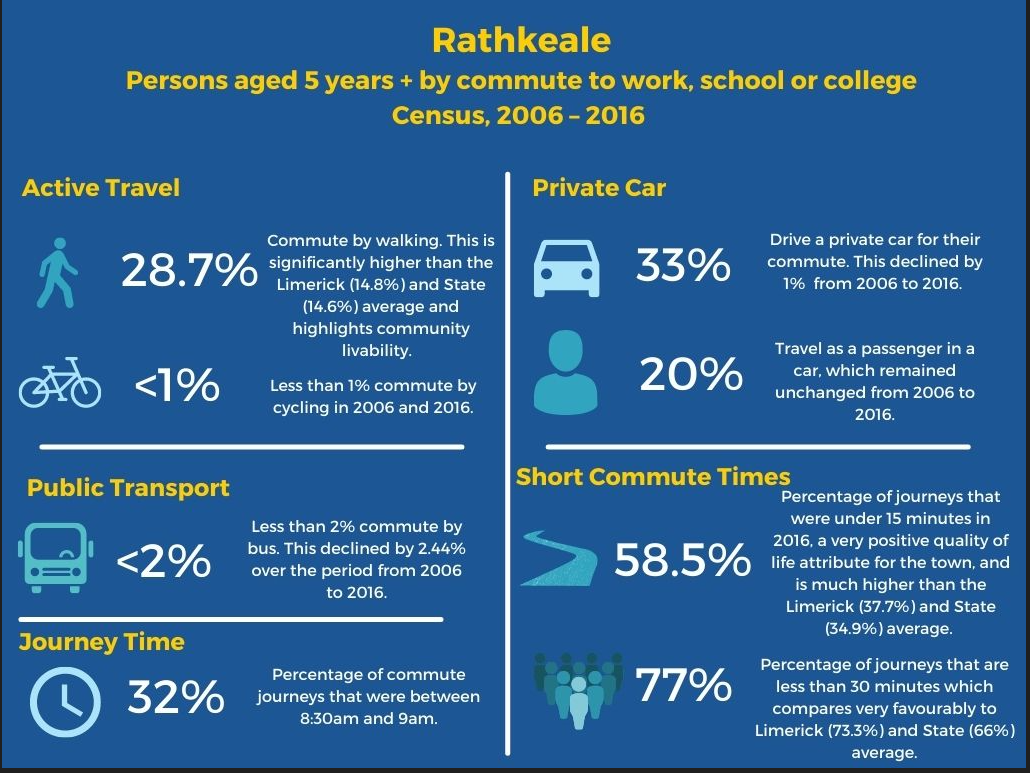
According the 2016 Census of Anonymised Records (POWSCAR) the daytime working population working in Rathkeale is 769 persons and of these 622 people (or 80.88%) commute into the town. These primarily commute into town by car.
The Draft Limerick Development Plan 2022 – 2028 set sets the following targets for the modal shift for Level 3 Settlements, including Rathkeale.
|
Settlement
|
Walk |
Cycle |
Public Transport |
|
Settlement Levels 3-6/Rural Areas (All Work/Education Trips) |
15% |
5% |
12% |
Table 3: Mode Shift Targets for commute to work, school or college, by 2028
The Council will work closely with other relevant agencies and stakeholders, including the NTA to support modal shift targets as above.
10.3 Sustainable Mobility and Transport Strategy and Objectives
Strategic Sustainable Mobility and Transport Objective
To promote and facilitate a sustainable development of a modern sustainable mobility and transport network in Rathkeale in accordance with the Draft Limerick Development Plan 2022 – 2028
Objectives: It is an objective of the Council to:
T O1:
(a) Encourage, promote and facilitate a modal shift towards more sustainable forms of transport in all developments.
(b) Support and facilitate implementation of an integrated, multi-modal and accessible public transport network in Rathkeale and its hinterland, including any investment in the public transport by service providers in Rathkeale.
(c) All new roads shall incorporate segregated cycle tracks and walkways designed in accordance with the National Cycle Manual.
T O2: Improve and seek investment for safe and direct pedestrian and cycleway link throughout the town, including connecting to the Limerick Greenway and a pedestrian and cycle connection across the River Deel to improve connectivity to the town centre and existing services including schools and other community facilities.
T03:
(a) Protect the capacity of the national road and regional road network from inappropriate development, having regard to all relevant Government guidance including “Spatial Planning and National Roads Guidelines” (DoECLG, 2012) and ensure development does not compromise the performance of the network or future improvements to network. Any future development proposals for the lands zoned Enterprise and Employment will require a Traffic and Transport Assessment to assess the impact of the proposal on the road network. The costs of the mitigation measures shall be borne by the developer.
(b) Prohibit advertising signage adjacent to the national road and regional road networks
(c) Ensure all developments protect and safeguard the capacity and efficiency of the drainage regimes of the national road, regional and local network.
(d) Seek opportunities to improve mobility and connectivity in Rathkeale, including the former Mart Site to provide improved connectivity between Main Street and New Line. Any proposed development shall provide for safe vehicular, pedestrian and cyclist movement. High quality public realm will be expected of this town centre redevelopment.
T O4: Facilitate and implement school streets and school zones, including slow zones around schools, and promote/facilitate active travel options for school children to reduce the health and safety risks associated with traffic congestion, pollution and inactive lifestyles. This includes the Safe Routes to School (SRTS) Programme in partnership with the NTA and Green-Schools as a response to support schools to encourage walking and cycling as the commute to schools.
T O5: Collaborate with transport providers to improve connectivity with the wider public transport fleet by facilitating necessary infrastructure in the town as required by the appropriate transport agency.
Contents
Observations
Observations