The road from Whites service station to Cois Deal is in a very bad condition, further along, towards Danaher’s Cross there’s an everyday speeding problem, a speed camera would at least gather...
Chapter 3 - Rathkeale in Context
Closed18 Jun, 2022, 8:00am - 2 Aug, 2022, 5:00pm
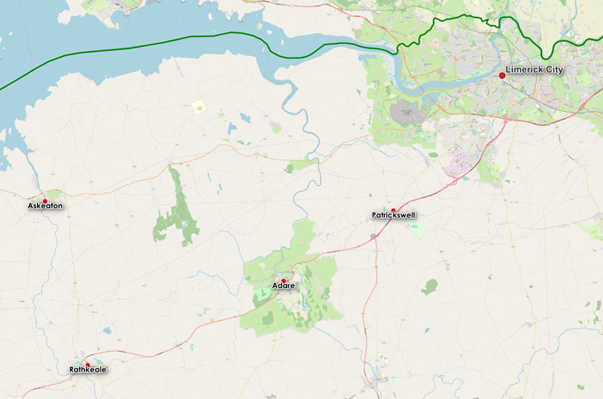
Rathkeale is located 31km south-west of Limerick City, 12km north-east of Newcastle West and 11km south of Askeaton. The town is by-passed by the N21 National Primary Road Limerick to Tralee road, located immediately to the north of the town. The Limerick Greenway – former railway line has been re-purposed for active mobility and tourism purposes, as a walking and cycling amenity, is located to the north of the town, partly within the Proposed LAP boundary. Rathkeale has a large agricultural hinterland extending to Adare, Newcastle West and Askeaton. The River Deel flows through the town entering the Shannon Estuary at Askeaton.
Given the level of service provision in Rathkeale, (public library, municipal district offices, health clinics, primary, secondary and early schooling/Youth Partnership programmes, professional services, retail, hotels, bulk retail, a business park, food processing, distribution, and automation/manufacturing), the Draft Limerick Development Plan identifies Rathkeale as having an important regional employment function within its catchment – an important local driver as a Level 3 Settlement sustaining a wider range of functions for the town and the surrounding rural hinterland. For Rathkeale to fulfil this role, the town requires consolidation of land use, catch–up in investment in services, infrastructure, sustainable transport, amenities and local employment balanced with quality housing delivery.
3.1 Demographic and Socio-economic profile
The principal demographic trends for the Rathkeale as set out in CSO Census data are outlined below. This data is significant in terms of the demands for schools, childcare facilities, housing responding to demographic changes, health-care, employment opportunities, as well as availability of labour force, standards of education/training attained and disposable income.
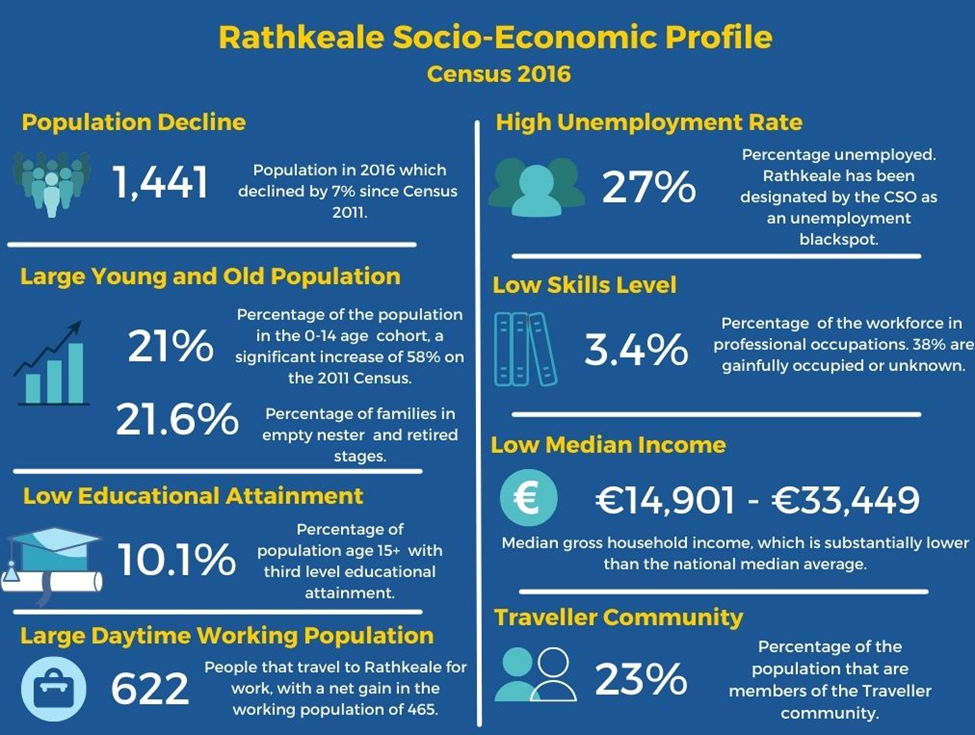
The Census CSO data boundary for the town of Rathkeale is more expansive than that of the settlement boundary of the Proposed LAP. The CSO is the only robust, credible, systematic source of data available to analyse at a local level social economic trends, and mobility/transport patterns available to support the policies and objectives of the Proposed LAP for the sustainable development of the town. However, as a local level spatial plan the Proposed LAP must comply with the higher-level spatial plans, that is the NPF and the RSES. This includes the principle of the a compact settlement prioritising the development potential of the town centre, sequential development from the town centre maximising under-used/vacant brownfield infill sites and existing buildings. Considering the existing built footprint of the town and to align with national spatial policy the settlement boundary for the Proposed LAP has been determined as per Map No.1 Land Use Zoning, Appendix 1.
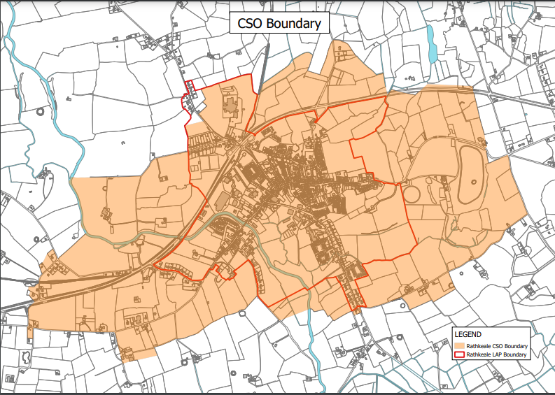
Figure 4: Comparative Boundaries of the Census CSO and the settlement boundary of Rathkeale in the Proposed LAP
3.2 Emerging Opportunities and Challenges for Rathkeale
Rathkeale is centrally located in Limerick and benefits from high quality connectivity to Limerick City and adjoining towns in the south west region. These assets have been important in attracting and sustaining industry and employment within the town. There is potential for further expansion of industry and employment in the town of Rathkeale. Tourism products, such as the Limerick Greenway, the heritage assets in the town offer further opportunities to develop the town centre.
Rathkeale has a number of challenges, including the movement of business in recent times from the town centre to the outskirts of the town, residential and commercial vacancy or under-use of land/buildings, dereliction, unfinished housing estates, adapting to climate Other challenges reflect the demographic issues of relatively poor educational attainment levels, levels of employment skills, types of employment, unemployment rates, the migratory nature of a substantial proportion of the community, levels of deprivation, and disposable income.
Infrastructure deficiencies are also present a challenge in Rathkeale, fluctuating water pressure, changing school enrolment demands throughout the year places pressure on existing services.
Contents
Observations
Observations