To whom it may concern,
Please see attached a submission on behalf of the Department of the Environment, Climate and Communications in relation to the Draft Abbeyfeale Local...
Chapter 8: Climate Action, Environment and Heritage
Dúnta15 Aib, 2023, 08:00 - 29 Bea, 2023, 17:00
8.1 Climate Action and the Environment
Climate change and the transition to a low carbon society has become a critical element of all land use plans. The effects of climate change are quickly becoming the biggest challenge facing society today posing a serious threat to quality of life, communities, businesses, the environment and biodiversity. Land use planning is a critical tool to mitigate and adapt to climate change and to the protection of our environment. Implementation of the LAP will take into account relevant targets and actions arising from sectoral plans in order to comply with the requirements of the Climate Action and Low Carbon Development (Amendment) Act 2021. This supports Ireland’s transition to Net Zero and achieving a climate neutral economy by no later than 2050.
The Limerick City and County Council Climate Change Adaptation Strategy 2019 - 2024 outlines that Climate Action comprises of two elements – (1) Adaptation and; (2) Mitigation. Adaptation is the efforts to manage the risks and impacts associated with existing or anticipated impacts of climate change, while mitigation is the efforts to reduce the emission of greenhouse gases, and reduces the severity of future climate change impacts.
Through the policies and objectives set out in the NPF and RSES, climate adaptation and mitigation measures are embedded in the plan-making process. The Draft Local Area Plan has been prepared with the purpose of integrating and implementing these policies and provisions where relevant. The approach to density, land use, design and movement is consistent with broader measures to address climate change in the areas of sustainable travel, green infrastructure, flood risk adaptation and renewable energy sources, amongst others.
There are a number of ways in which a Local Area Plan can seek to reduce the carbon footprints and mitigate against the negative impacts of climate change. These include:
- Promoting the provision of blue green infrastructure (planting of trees, hedgerows, woodlands, construction of surface water retention features, such as ponds, lakes or swales);
- Promoting climate proofing in the design of buildings and neighbourhoods;
- Promoting the use of indigenous resources and adaption of new building techniques and designs that minimize energy intensive inputs;
- Seek to improve energy performance ratings on existing and new buildings. All new homes constructed must reach an energy performance rating in accordance with Part L – Conservation of Fuel and Energy 2019, which gives effect to Nearly Zero Energy Building (NZEB) Regulations.
- Promote the use of SuDS and nature-based solutions such as riparian buffers as climate adaption options to address flood risk and support biodiversity and associated micro-climates, and linked wildlife corridors.
Policy CH 1: Climate Change: It is policy of the Council to:
Protect and enhance environmental quality and implement the climate action measures through the planning process to help address climate change.
Objective CH 01: Climate Change: It is an objective of the Council to:
- Ensure climate-proofing measures are incorporated into the design, planning and construction of all developments, including utilities and their networks. The use of green infrastructure as a mechanism for carbon offsetting and surface water management is encouraged.
- Ensure that all residential and commercial developments are designed to take account of the impacts of climate change, including the installation of rainwater harvesting systems, and that energy efficiency and renewable energy measures are incorporated. In the case of large industrial, commercial or newly constructed public buildings, the incorporation of renewable technologies, such as solar energy in the design will be encouraged, subject to compliance with all relevant planning criteria.
- Support and promote climate smart and the NZEB standard of building or equivalent for all new developments.
- Promote and support development of renewable energy sources, which will achieve low carbon outputs and promote Abbeyfeale as a low carbon area.
- Support the development of low carbon and green technological businesses and industries.
- Promote responsible development and management of land, drainage systems and natural habitats and encourage development at appropriate locations, which minimise the use of fossil fuels and maximises the use of local or renewable resources.
- Promote the appropriate adaption of built heritage to respond to the effects of climate change.
- Protect and enhance environmental quality and implement current and future climate action measures and guidance that may be published during the life time of the plan through the planning process to help address climate change.
8.2 Biodiversity and Blue Green Infrastructure
Blue green infrastructure refers to the incorporation of blue elements (water environments), like rivers, canals, ponds, wetlands, floodplains, water treatment facilities, and green elements, such as trees, forests, fields and parks, in urban and land-use planning. This infrastructure uses natural processes, such as filtration or absorption to address water and air quality. Blue and green infrastructure can exist side by side in a complimentary relationship, such as the rivers, their banks and vegetation include trees and hedgerows. This Plan promotes networks of blue green infrastructure as aligned with higher-level plans, including the Limerick Development Plan 2022-2028, and the Regional Spatial and Economic Strategy for the Southern Region. 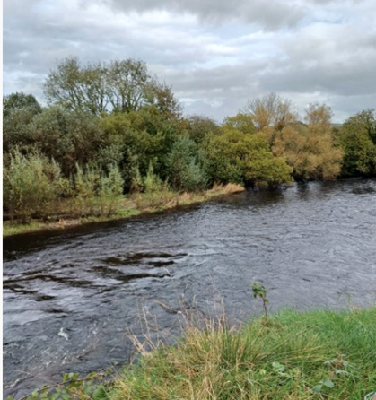
Figure 8.1 – Vista from Abbeyfeale Town Park of the River Feale
This Draft Local Area Plan can help mitigate further impact on the environment through ensuring that future development takes cognisance of the natural elements of sites and incorporates them within the design of buildings and neighbourhoods, connecting them into the wider blue green infrastructure network. Where there are no natural site features present, the potential for a landscaping plan to re-establish green features and infrastructure should be examined.
The River Feale and its tributaries, the River Allaughan and the Glórach stream flowing through Abbeyfeale are within the Lower Shannon Special Area of Conservation (SAC) catchment. The legal basis on which SACs are selected and designated is the EU Habitats Directive, transposed into Irish law by the European Communities (Birds and Natural Habitats) Regulations 2011 (S.I. No. 477 of 2011), as amended. In particular, this watercourse is important for the Freshwater Pearl Mussel and Salmon. There are no Special Protections Areas (SPAs) designation under the Birds Directive or Natural Heritage Areas (NHAs) under the Wildlife (Amendment) Act 2000 in the Draft LAP area. There are no designated geological sites within the Plan area. The main soil types are generally gleys, alluvial soils, with peat bog soils in the surrounds of the town.
A wide diversity of species, habitats, ecosystems and landscapes make up the biodiversity of the town found at the wildlife corridors of the Limerick Greenway, the banks of the River Feale and the River Allaughan and the tributary known locally as the Glórach stream. Connected green spaces provide the greatest benefit to biodiversity in an urban context. In this regard, there is an opportunity to recognise the key conservation role the watercourses plays in the town’s biodiversity. Existing trees and hedgerows are important features supporting biodiversity and should be carefully considered in any planning application. This Plan seeks to protect existing ecosystems and biodiversity assets, such as natural woodland, natural watercourses and riparian habitats, layered ecosystems supporting flora, fauna, pollinators, invertebrates, micro-organisms and mycelium.
Applications shall seek to retain hedgerows, landscaped areas, retention or planting of trees and preservation of natural features where possible. Suitable planting of new edge or buffer treatments will be encouraged as part of new developments. These areas will emphasize enhancement of local biodiversity and local surface water management, while enhancing visual amenity. Management of invasive species, prior to and during construction shall be considered.
Limerick City and County Council have a Blue Green Infrastructure (BGI) Strategy, which will be used to inform and guide the planning and management of BGI within Limerick City and Suburbs. Many of the BGI principles will also be relevant to Abbeyfeale. BGI has far-reaching benefits, including the creation of places, which improve physical and mental health, contributes towards the provision of space for nature, and plays a vital role in climate change mitigation and adaptation along with many economic benefits.
This strategy identifies a number of specific, interlinked and cross-cutting themes. The Draft Local Area Plan for Abbeyfeale, includes a number of policies and objectives that will guide the direction and support the delivery and enhancement of BGI within the town. These ‘Enhancement Opportunities’ are outlined in Table 6 and includes the associated key cross compatible Climate Change themes. The benefits of implementing BGI are as follows:
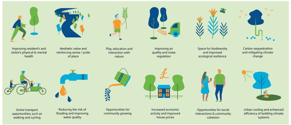
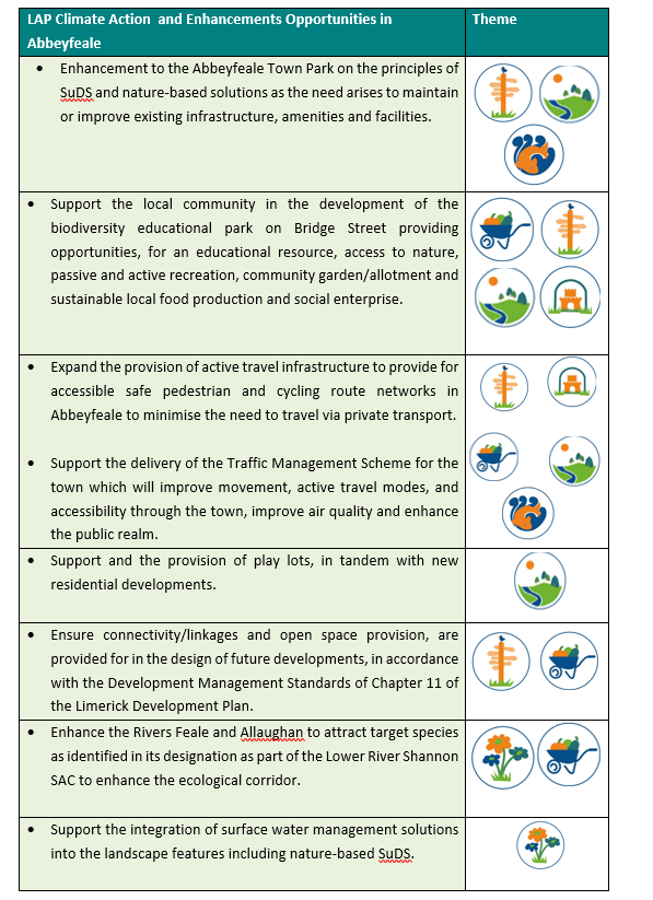
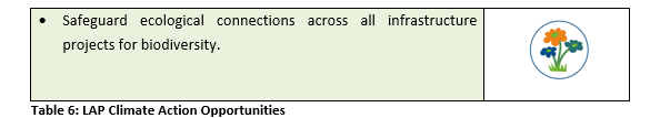
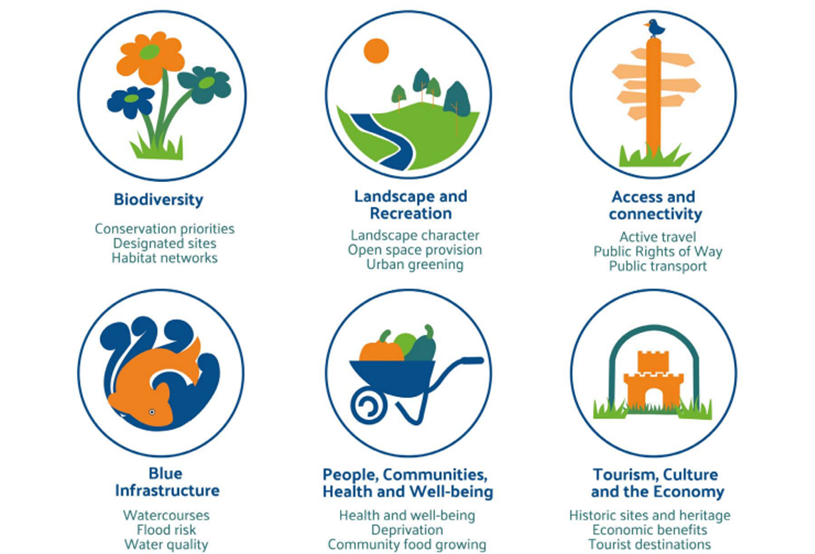
Table 7 - Inventory of Blue – Green Infrastructure assets in Abbeyfeale
|
Feature |
Local name |
Condition/Description |
Asset Value |
|
River Feale |
As indicated |
Good – Designated part of the Lower River Shannon SAC.
|
A key natural resource adjacent to the town park located on the outskirts of the town offering access to riverine biodiversity of the riverbank. |
|
River Allaughan |
As indicated |
Good – Designated part of the Lower River Shannon SAC. |
A natural watercourse within walking distance of the town centre |
|
Abbeyfeale Town Park – Páirc na Féile |
As indicated |
Good – offers a range of amenities including woodland, outdoor sport and exercise infrastructure, playground, 7km walkway/cycleway, on 30ha adjacent to the banks of River Feale. |
Access to woodland and riverine biodiversity, and promotes active lifestyles and social interaction as a community park. However, the aggressive riverine erosion to the riverbank in the park is a challenge. |
|
Limerick Greenway and North Kerry Greenway |
As indicated |
Good – part of the Limerick Greenway cycleway/walkway, functions as a rich biodiversity corridor facilitating access to nature by local community and tourists. |
Sustains biodiversity, promotes active lifestyles and active travel connectivity with settlements on the Greenway in Limerick and North Kerry such as Listowel, Newcastle West and Rathkeale. A safer connection between the town centre and the Greeenway is required. |
|
Local walking loop |
Slí na Sláinte |
Good street pathways on a 6.8km route along Main Street, Doctor’s Road and New Street. |
Looped walking route for the town, well used and popular among locals – infrastructural upgrades needed in places - public amenity value, connectivity and lifestyle. |
|
Biodiversity Educational Space |
New Street by Feale Bridge |
A partnership between the Council and Abbeyfeale Community Council to bring into use a vacant site as an community garden for biodiversity and potential social enterprise in local produce.it also represents an important educational resource.
|
Social interaction, active lifestyle, opportunities for social enterprise and local produce production, access to biodiversity as an educational resource within walking distance to town centre and schools. Funding and resources required to progress the potential of this site. SuDS and nature-based solutions a key element of any future development. |
Objective CH 02: Blue Green Infrastructure: It is an objective of the Council to:
a) Develop and enhance blue and green infrastructure opportunities throughout Abbeyfeale and in line with the detail set out in Table 6: LAP Climate Action Opportunities.
b) Promote connecting corridors for the movement of species and encourage the retention and creation of features of biodiversity value, ecological corridors and networks that connect areas of high conservation value, such as woodlands, hedgerows, earth banks, watercourses, wetlands and designated sites where possible. In this regard, new infrastructural projects and linear developments in particular, will have to demonstrate at design stage, sufficient measures to assist in the conservation of and dispersal of species.
c) Protect existing ecosystems and biodiversity assets, such as natural woodland, natural watercourses and riparian habitats, layered ecosystems supporting flora, fauna, pollinators, invertebrates, micro-organisms and mycelium, where possible.
8.2.1 Water Framework Directive
The European Union Water Framework Directive (WFD) was signed into law in October 2000. The Water Framework Directive (WFD) brings an integrated approach to managing water quality on a river basin (catchment) basis, in order to protect and enhance both ecological and chemical quality of rivers, lakes, groundwater, estuaries and coastal waters.
The WFD is implemented through River Basin Management Plans (RBMPs) in three six-year cycles. Each cycle providing an opportunity to assess water conditions at different stages and set out actions to achieve water quality objectives. The third cycle runs from 2022-2027. Local Authorities are responsible for the development and implementation of RBMPs at a local level.
Policy CH 2 Water Framework Directive Policy: It is policy of the Council to:
Implement changes to the management of water bodies, taking account of all aspects of the Water Cycle in accordance with the Water Framework Directive and the principal objective of the WFD to achieve at least good status in all waters and to ensure that status does not deteriorate in any waters.
8.2.2 Special Area of Conservation
The Draft LAP seeks to protect the ecological integrity of the river by maintaining a buffer along the River Feale and River Allaughan, which prevents the encroachment of future development onto the riverbank as recommended by Inland Fisheries Ireland.
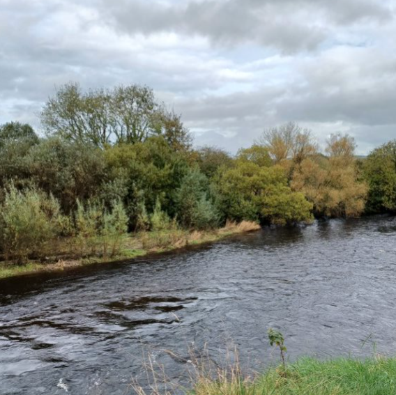
Figure 8.3 – Special Area of conservation Abbeyfeale taken from Abbeyfeale Town Park
These watercourses are recognised as an important amenity for the town and are valued as a natural habitats. Natura 2000 is a European network of important ecological sites. The EU Habitats Directive (92/43/EEC) placed an obligation on Member States of the EU to establish the Natura 2000 network. The network is made up of Special Protection Areas (SPAs), established under the EU Birds Directive (79/409/EEC), and SACs, established under the Habitats Directive itself. The Lower River Shannon has been designated as a Special Area of Conservation (SAC). Both the River Feale and the River Allaughan are part of the Lower Shannon SAC. This designation has implications for development, in terms of buffer zones, but also constitutes an opportunity, as the designation of such areas is generally in recognition of good species, diversity and river quality, which would have implications for angling and other water-based activities. This Plan zones 9 ha as Semi-Natural Open Space which respects the designation of the SAC.
Appropriate recreational development may be considered subject to environmental considerations, where it can be satisfactorily demonstrated that there will be no impact on the integrity of this Special Area of Conservation or on the natural habitat of the river and its designation as part of the Lower River Shannon Special Area of Conservation.
A number of field boundaries within the plan area, form an essential part of the natural fabric of the area. Any natural stone boundary walls should be retained where possible. Similarly, any mature tree coverage should be a key consideration in the design of future developments and shall be retained where possible.
This Local Area Plan seeks to protect, preserve and enhance the natural heritage for the benefit of future generation as well as safeguarding the continued and sustainable use of this asset.
Objective CH 03: Special Area of Conservation: It is an objective of the Council to:
a) Protect and maintain the integrity of the Special Area of Conservation by the River Feale and protect the watercourses in Abbeyfeale, in accordance with the Semi-Natural Open Space zoning designation on the Land Use Zoning Map and the lands zoned Agriculture by the River Allaughan.
b) Ensure the protection of a 20m riparian buffer zone on greenfield sites free from development. Proposals shall have cognisance of the contents of the Inland Fisheries Ireland document Planning for Watercourses in Urban Environments.
c) Ensure that appropriate wastewater infrastructure is available to support new developments to safeguard water quality.
d) No projects which will be reasonably likely to give rise to significant adverse direct or indirect or secondary impacts on the integrity of any Natura 2000 sites, having regard to their conservation objectives arising from reduction in species diversity, shall be permitted on the basis of this plan (either individually or in combination with other plans or projects)[1].
e) To seek to ensure the sustainable and responsible management of all leisure fishing and water-based activities within the Lower River Shannon SAC, in consultation with the National Parks and Wildlife Service and/or Inland Fisheries Ireland where relevant, and in compliance with the Salmonid River Regulations (SI No. 293/1988) and the Habitats Directive.”
Objective CH 04: Tree Protection and Nature Conservation: It is an objective of the Council to:
Seek to protect natural stone boundary walls, ponds/wetlands, other natural features of local importance and mature trees, where possible. Development that requires the felling or harming of such trees will not generally be permitted, unless supported by a tree survey establishing that the subject trees are of no ecological or amenity value. Such report shall be undertaken by a suitably qualified and competent person.
8.3 Built Heritage and Archaeology
Limerick City and County Council is obliged to compile and maintain a Record of Protected Structures (RPS) under the provisions of the Planning and Development Act 2000 (as amended). Under the Act, Local Authorities must include objectives for the protection of structures, or parts of structures, which are of special architectural, historical, archaeological, artistic, cultural, scientific, social or technical interest. The complete list for Limerick City and County is available as Volume 3 of the Limerick Development Plan. A Protected Structure, unless otherwise stated, includes the interior of the structure, the land lying within the curtilage of the structure, and other structures lying within that curtilage and their interiors. The protection also extends to boundary treatments.
There are 61 Protected Structures in Abbeyfeale and 31 of these structures are also listed on the National Inventory of Architectural Heritage (NIAH) such is their significance at a regional and national level. The diversity of structures on the Record of Protected Structures lists, includes railway buildings, religious buildings, the buildings and terraces of the traditional vernacular streetscape and shopfronts, medieval structures (Refer to Appendix III). There is an onus on the owner and/or occupier of a protected structure to ensure that the structure or any element of it is not endangered. Endangering a structure can mean either directly or indirectly damaging any element of the structure or neglecting the structure to the extent that it is damaged. When considering works, including minor works to a Protected Structure you are advised to contact the Conservation Officer to ascertain obligations in terms of the proposed development to avoid damage to the integrity of the historical built fabric of the structure. Some minor works, while exempt from planning permission in general circumstances may not apply to Protected Structures.
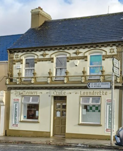
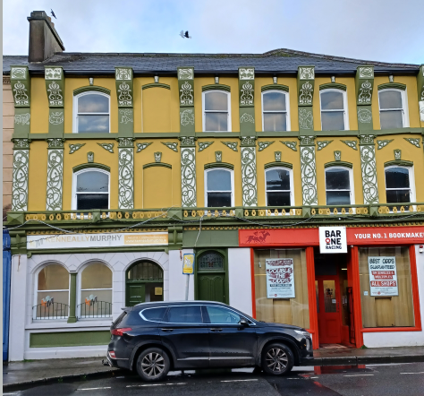
Figure 8.4 – Examples of Protected Structures in Abbeyfeale
The National Inventory of Architectural Heritage (NIAH) was established under the provisions of the Architectural Heritage (National Inventory) and Historic Monuments (Miscellaneous Provisions) Act 1999. The purpose of the NIAH is to identify, record and evaluate post 1700 architectural heritage. The Department of Culture, Heritage and the Gaeltacht carried out the survey to inform the preparation of the NIAH.
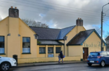
Figure 8.5 – Example of NIAH 21833001 Teach na Féile and Protected Structure RPS 752 in Abbeyfeale
8.3.2 Architectural Conservation Area (ACA)
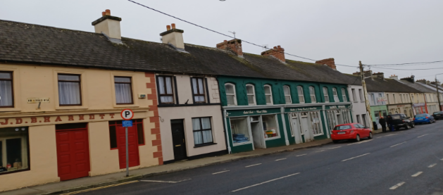
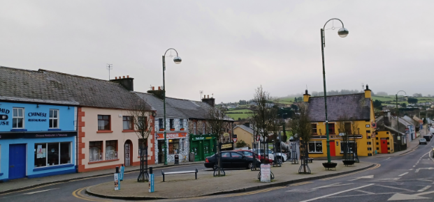
The Abbeyfeale ACA is generally defined by the historic core, comprising the Square, parts of Main Street, Bridge Street and Church Street. There are 30 Protected Structures in this ACA, and 12 of these structures are also NIAH structures. There are a number of Recorded Monuments associated with the Cistercian complex north of the Square. Buildings are generally two and three storeys, with render, redbrick or limestone finish. Many display ornate stucco, decorative quoin embellishments on the front façade, a feature found throughout West Limerick/ North Kerry. Building lines in Abbeyfeale reflect the traditional Irish streetscape. Each individual building, be it for commercial or residential purposes, tended to have its own distinct plot of land.
The collective arrangement of buildings within these areas are considered of significance to the built heritage of the town and contributes to the character and established street and townscape. It is the objective of the Council to preserve the character of these areas and therefore they are designated as Architectural Conservation Areas (ACA). The ACA is defined on the Protected Structures and ACA Map 4. The designation of the ACA does not preclude future development, but the carrying out of works to the exterior of structures within the ACA shall not be considered as exempted development where those works would materially affect the character of the ACA. In assessing development proposals within the ACA, the Council shall take into account the material effect that the proposed development would be likely to have on the character of the ACA.
In undertaking repairs or maintenance works to buildings in the Abbeyfeale Architectural Conservation Area, property owners and their contractors should be aware of the materials traditionally used in the county, and more specifically, in the town itself and its immediate surrounds.
Works in Conservation Areas must retain existing surviving elements, aim to re-instate lost elements or character, with new builds complementing the original streetscapes, building lines and open areas. Proposals for new buildings should not seek to dominate the historic core and should respect the historic fabric of the buildings and the morphology of their plots.
Where original or early surviving elements, such as windows and doors, rainwater goods of rolled mild steel or cast iron (or a combination of both), natural slate roofing and lime renders, and so forth, then these should be repaired sensitively. The guidance here is to “do as much as necessary and as little as possible”. If replacement proves necessary, then they must be replaced on a “like-for-like” basis.
In replacing elements that were installed as replacements in recent decades, such as aluminium windows or smooth finish artificial slate, there are good reasons, apart from those put forward on the basis of architectural heritage, to return to the original materials, such as timber windows and natural slate. These reasons include the compatibility of traditional materials with one another and the fact that the historic material allows the building to breathe, thereby providing a healthier internal atmosphere for those using the buildings.
Objective CH 05: Built Heritage: It is an objective of the Council to:
Promote the protection and improvement of built heritage in accordance with the NPO 11 of Project Ireland 2040, RSES, Limerick Development Plan 2022 – 2028 and Section 28 Guidelines, including the Architectural Heritage Protection Guidelines for Planning Authorities.
Objective CH 06: Protected Structures: It is an objective of the Council to:
- Resist the demolition of Protected Structures, in whole or in part, the removal or modification of features of architectural importance, and design element that would adversely affect the character or setting of a Protected Structure, unless exceptional circumstances can be clearly demonstrated by a suitably qualified professional.
- Protect Protected Structures and attendant grounds in accordance with the best conservation practice and relevant heritage legislation
- Support the re-introduction of traditional features on Protected Structures where there is evidence that such features (e.g. window styles, finishes etc.) previously existed.
- Positively consider proposals to improve, alter, extend or change the use of Protected Structures and attendant grounds so as to render them viable for modern use. Proposed works shall be subject to demonstration by a suitably qualified Conservation Architect or other relevant expert that the structure, character, appearance and setting will not be adversely affected and, suitable design, materials and construction methods will be utilised in accordance with best conservation practice and relevant heritage legislation.
- Promote awareness of the appropriate adaption of built heritage to climate change as per Heritage Ireland 2030, the Climate Change Sectoral Adaptation Plan for the Built and Archaeological Heritage, 2019, the Built Vernacular Strategy, 2021, the National Policy on Architecture, the Limerick Climate Adaption Strategy 2019 – 2024 and higher-level spatial plans. The Council have regard to the Department of Environment, Heritage and Local Government’s publication on Energy Efficiency in Traditional Buildings (2010) and the Irish Standard IS EN 16883:2017 Conservation of Cultural Heritage – Guidelines for Improving the Energy Performance of Historic Buildings (2017) and any future advisory documents in assessing proposed works on Protected Structures.
Objective CH 07: Architectural Conservation Areas (ACA’s): It is an objective of the Council to:
- Protect, conserve and where appropriate, enhance the ACA’s as identified in Map 4. The design of any development proposed in the Architectural Conservation Area, including any changes of use of an existing building, should preserve and/ or enhance the character and appearance of the Architectural Conservation Area as a whole.
- Promote shopfront improvements and building facades enhancements in Abbeyfeale town centre, with particular focus within the ACA, while safeguarding the character of the buildings and subject the necessary consents and funding.
- Proposals for development within the ACA’s shall;
- Reflect and respect the scale and form of existing structures within the ACA’s in proportioning, overall scale and use of materials and finishes, particularly with reference to the street frontages and seek to contribute to or enhance the character and streetscape of the ACA’s;
- Seek to retain/incorporate/replicate exterior features which contribute or enhance the character and streetscape of the ACA’s such as shop fronts, sash windows, gutters and down pipes, decorative plasterwork etc.;
- Ensure priority is given to the pedestrian, to inclusive access, and to facilitating the improvement of the quality of the public realm: the latter will include for consideration of planting of trees in the wider public open spaces, benches for sitting and the articulation of uses through appropriate paving.
[1] Except as provided for in Article 6(4) of the Habitats Directive, viz. There must be: a) no alternative solution available, b) imperative reasons of overriding public interest for the plan to proceed; and c) Adequate compensatory measures in place.
Clár ábhair
Tuairimí
Tuairimí