See submission attached.
Chapter 1 - Introduction
Closed6 May, 2023, 8:00am - 19 Jun, 2023, 5:00pm
1.1 What is a Local Area Plan?
A Local Area Plan (LAP) is a land-use plan which sets out the development strategy for an area within the lifetime of the plan prepared by the Planning Authority, in accordance with the requirements of the Planning and Development Act 2000 (as amended), thereafter referred to as “the Act”.
The Newcastle West LAP 2014 - 2020 was extended until 2024 under Section 19 of the Planning and Development Act 2000 (as amended).
The adoption of the LAP is a reserved function of Elected Members of the Municipal District of Newcastle West.
The plan contains an overall vision for the area and includes specific land use objectives to guide future development to achieve this vision. The new LAP will consider the current context of Newcastle West, in terms of population trends, socio economic factors, land use changes, the need for the distribution of facilities and amenities, availability of services and infrastructure, along with heritage and environmental considerations.
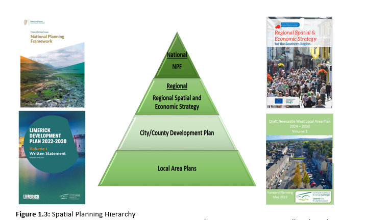
The LAP must be consistent with the objectives of the higher order plans, including the Limerick Development Plan, the Regional Spatial and Economic Strategy (RSES) for the Region and the National Planning Framework.
The RSES seeks to support and grow the role of Newcastle West, as a driver of economic development for County Limerick and wider region. Newcastle West is identified as a Key Town in the RSES.
As part of the proposed plan, a new zoning map will be prepared to take account of current and future population needs of Newcastle West, subject to environmental and other planning considerations.
There are three key components of this Local Area Plan:
•Volume 1: Contains the Written Statement for the LAP, which includes the development strategy for the life of the Plan, including Policies and Objectives, Land Use Zoning, Record of Protected Structures, Architectural Conservation Areas (ACA) and Record of Monuments and Places (RMP) maps.
•Volume 2: Contains Local Transport Plan.
•Volume 3: Contains Strategic Environmental Assessment (SEA), Appropriate Assessment (AA), Natura Impact Report (NIR) and Strategic Flood Risk Assessment (SFRA).
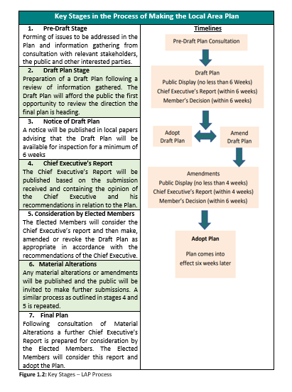
Given the expiration of the extended lifetime of the existing Newcastle West Local Area Plan in 2024, a new LAP is required for the town. Section 20 of the Planning and Development Act 2000 (as amended) sets out the process for the making of a Local Area Plan as outlined in Figure 1.2 below. The formal process, for the preparation of this Draft Local Area Plan commenced on 28th January 2023, with the publication of the Issues Paper.
Public consultation is an important aspect of any plan-making process, including the pre-draft stage, in order to identify local issues relating to Newcastle West, and to ensure that the final LAP acknowledges community aspirations and concerns. Public consultation during this pre-draft stage, included:
-The publication of an Issues Paper;
-Engagement with primary schools including Courtenay School and Gaelscoil Ó Doghair;
-Engagement with post primary schools including Desmond College and Scoil Mhuire agus Ide;
-The transition year students from both schools also trialled a digital mapping tool, developed by Limerick City and County Council to assist school students to identify issues, which they wanted to be addressed in the Local Area Plan;
-A public consultation evening held on the 23rd February 2023 in Newcastle West; and an online social media campaign was formulated to keep the public informed.
During the public consultation period for the pre-draft stage, 22 no. written submissions were received and the students' submitted maps and numerous digital responses through the mapping tool. The preparation of the Draft Plan has been informed by these submissions and by consultation with relevant stakeholders, service providers, Government Departments and with internal Local Authority departments.

Figure 1.1: Students of 5th Class Courtenay School Newcastle West identifying issues in Newcastle West
The publication of the Draft Plan will include further public consultation, in line with the requirements of the Planning and Development Act 2000 (as amended). During this time, written submissions will be invited and considered in a Chief Executive’s Report to be issued to the Elected Members of the Municipal District of Newcastle West. Subsequent to consideration of the Chief Executive’s Report and its contents, there may be further consultation on Material Alterations, prior to the adoption of the Local Area Plan by the Elected Members. The Planning Authority envisage that the final Plan will be adopted late 2023.
The LAP must be consistent with the objectives of the higher-level spatial plans, including the National Planning Framework (NPF), the Regional Spatial and Economic Strategy for the Southern Region (RSES) and the Limerick Development Plan 2022 – 2028.
1.3.1 National Planning Framework
Newcastle West has been defined as an Urban Settlement by the CSO and this reference has been mentioned in the National Planning Framework (NPF). A primary focus of the NPF is to deliver an increased level of population, jobs and activity generally within existing urban areas, which include towns such as Newcastle West. This approach requires the creation of compact urban development, achieving brownfield and infill targets through innovative design approaches to appropriate density and height reflecting desirable places that can attract more people and generate new employment opportunities all within the existing footprint of towns, such as Newcastle West.
1.3.2 Regional Spatial and Economic Strategy (RSES)
Newcastle West is designated a Key Town in the RSES for the Southern Region. Regional Policy Objective RPO 35 of the RSES seeks to develop urban places of regional scale through delivering significant compact growth in Key Towns including Newcastle West. This will be achieved by focusing on delivering new homes, within the existing built up footprints of settlements such as Newcastle West.
The RSES supports a “ten-minute” sustainable town model where short travel time and ease of access via sustainable travel modes is achieved between where we live, work, access services, access recreation and amenity inter alia;
RPO 22 sets out the 5 specific objectives for Newcastle West as follows:
(i) To support and promote the role of Newcastle West as a strategically located urban centre of significant influence in a sub-regional context. In particular, it is an objective to promote the opportunity for interregional collaborations across county boundaries with Abbeyfeale, Listowel and Rathkeale and locations identified in the Strategic Integrated Framework Plan for the Shannon Estuary, which offer collective strengths and potential for project partnerships to drive sustainable economic growth in the West Limerick/North Kerry area;
(ii) To support the initiatives of the Atlantic Economic Corridor to realise the full potential of the Newcastle West enterprise assets to support job creation, improve competitiveness, attract investment and create future economic growth;
(iii) To support the delivery of the infrastructural requirements identified for Newcastle West, subject to the outcome of the planning process and environmental assessments;
(iv) To support and promote the tourism potential of Newcastle West’s historical heritage to facilitate the expansion of the existing tourism offer and to develop connectivity to and synergies with Newcastle West and the Limerick Greenway;
(v) To support the identification of opportunities for investment in incubation and innovation infrastructure for ICT and related companies and capitalise on Newcastle West’s ability to accommodate remote working, enterprise start-ups and up scaling companies.
The key infrastructural requirements are also identified as:
(i) Newcastle West Distributor Road and other transport measures through a Local Transport Plan;
(ii) Wastewater treatment and water services improvements;
(iii) Development of a regional athletics hub to service 9 athletic clubs and 41 primary and post-primary schools in the catchment area of Newcastle West;
(iv) Investment for the development and full utilisation of the Limerick Greenway.
1.3.3 Limerick Development Plan
It is an objective of the LDP 2022 to 2028 to promote Newcastle West as a key service centre and to promote the sustainable growth of the town to become a self-sufficient settlement and act as a service centre for its inhabitants and rural hinterland.
The Core Strategy of the Limerick Development Plan 2022-2028 makes assumptions with respect to population projections and allocation in Limerick and in settlements across County Limerick. These assumptions include the additional residential units and zoned land requirements for each settlement, in accordance with the NPF, the Implementation Roadmap for the NPF and the RSES. The Limerick Development Plan is also informed by the Regional Demographics and Structural Housing Demand at County Level.
Spatial Planning Objective 01:
It is an objective of the Council to ensure that provisions of the Draft Newcastle West Local Area Plan 2023 – 2029 for population and economic growth align with the policies and objectives of the higher-level spatial plans, including the National Planning Framework (NPF), the Regional Spatial and Economic Strategy for the Southern Region (RSES) and the Limerick Development Plan 2022-2028.
1.4.1 Strategic Environmental Assessment
Under the Planning and Development (SEA) Regulations 2004 (S.I. No. 436 of 2004) as amended by the Planning and Development (SEA) (Amendment) Regulations 2011, (S.I. No. 201 of 2011), there is a requirement for Strategic Environmental Assessment (SEA) of all Local Area Plans for areas that have a population or target population of 5,000 persons or more. Newcastle West has a population exceeding this threshold; therefore, a full SEA is required as a part of the Plan-making process.
A Strategic Environmental Assessment (SEA) of the Plan has been prepared in accordance with Directive 2001/42/EC (“the SEA Directive”). The purpose of the SEA Directive is to ensure the environmental consequences of plans are identified and assessed during their preparation and are modified where adverse impacts are likely and/or appropriate mitigation measures are incorporated to alleviate potential impacts. The SEA recognises and considers the value of ecosystems, the interplay between different ecosystems and how each policy intervention can have positive and negative effects on the constituent and cumulative parts of the environment.
An SEA Scoping Report was prepared and issued to the Environmental Authorities and submission were received. The SEA Scoping Report, dated January 2023 has informed the preparation of the Draft Plan and the SEA Report, which is contained in Volume 3. The findings of the AA and SFRA have also informed the SEA.
The report sets out a series of recommendations which have been fully integrated into Plan.
An Appropriate Assessment (AA) is required and has been prepared in accordance with Articles 6(3) and 6(4) of the European Communities Directive 92/43/EEC (Habitats Directive). This is contained in Volume 3 of the Plan. The mitigation measures identified in the Stage 2 Appropriate Assessment - Natura Impact Report has been incorporated into the Plan. The emerging conclusion of the AA is that the Plan will not affect the integrity of the European Sites, alone or in combination with other plans or projects.
1.4.3 Strategic Flood Risk Assessment
A Strategic Flood Risk Assessment (SFRA) has been prepared in accordance with the requirements of The Planning System and Flood Risk Assessment Guidelines (DEHLG, 2009) and Circular PL02/2014 (August 2014). All SFRA recommendations have been integrated into the Plan with a precautionary approach applied to the zoning of lands identified as potentially at risk of flooding.
1.4.4 Climate Action
The NPF and the Climate Action Plan 2023 have set out the scale of the climate change challenge. It has established a national policy position to achieve a 50% reduction in overall greenhouse gas emissions by 2030 and sets a path to reach net-zero emissions by no later than 2050, as committed to in the Programme for Government and the Climate Act 2021. To achieve this objective, radical change is required in how we plan our cities, towns and rural areas. This Plan places climate action at the heart of its vision and will promote a framework to achieve compact growth and best practice in achieving a reduction in our carbon footprint. Climate Change is a crosscutting theme of the LAP. In reinforcing climate action, this Plan places a priority and focus on enhancing and protecting the biodiversity, natural heritage and environment of the town. The SEA of the Plan, in accordance with the National Adaptation Framework (2018), supports the integration of climate action and land use considerations in the plan-making process.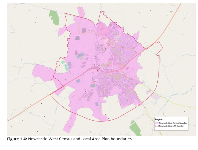
Contents
Observations
Observations
OPR's submission on the Draft Newcastle West Local Area Plan 2023-2029
A chara,
Please see attached the OPR's submission on the Draft Newcastle Local Area Plan 2023-2029.
Kind regards,
Eoin Daly