Please find attached the NTA's submission
Chapter 7 - Sustainable Mobility and Transport
Closed6 May, 2023, 8:00am - 19 Jun, 2023, 5:00pm
Chapter 7 Sustainable Mobility and Transport of the Limerick Development Plan 2022-2028 sets out a series of Policies and Objectives which establishes the sustainable transport priorities for Limerick over the lifetime of the plan. A key tenet of the NPF is the delivery of improved sustainable mobility in our cities, towns and villages. This accords with Ireland’s Climate Change mitigation plan, whereby a concerted effort is made to move away from polluting and carbon intensive population systems to new cleaner technologies. As a Key Town, the Newcastle West LAP includes a Local Transport Plan (LTP) in Volume 3. The aim of this document is to improve the integration of Land Use and Transport Planning in the preparation of this local area plan. This will be delivered in tandem with sustainable compact growth in the plan area, through appropriate means such as the development of lands in the existing built-up footprint of the town.
The LTP has been prepared in close collaboration with the National Transport Authority (National Transport Authority) and Transport Infrastructure Ireland (TII). National and Regional planning policy emphasises the efficient movement of people and goods, through an integrated multi-modal, accessible and affordable transport network that enhances competitiveness, economic progress, balanced regional development, social cohesion and equality for all in terms of accessing opportunities, for business and citizens alike. National Active Travel policy promotes reducing the demand for travel and the reliance on the private car in favour of public transport, car-pooling, cycling and walking as means to healthier lifestyles, climate change and improved air quality. Active Travel is travelling with a purpose using your own energy, such as walking (including all users of footpaths) or cycling as part of a purposeful journey. A key objective of active travel and its infrastructure is to ensure active travel can be seamlessly built into everyday life as part of normal daily routines including the commute to school, college or work. As Newcastle West is located on the Limerick Greenway, active travel and accessibility from the Greenway to the Town Centre are key requirements of this plan.
Compact settlements are conducive to sustaining the critical mass of population or employees to justify infrastructural investment in transport networks. Central to this is the application of the 10 minute town concept whereby all community services, employment opportunities and residences are within walking distance, thereby not requiring transport by car. A fundamental role of a local area plan is to guide the location of land uses considering the integration of good land use planning with transportation to unlock significant improvements in the quality of life, including more sustainable modes of movement which also have a role in achieving climate targets including smart vehicles and electrification of the national fleet and private vehicles.
7.1.1 Movement and Accessibility
Newcastle West is a compact town, with most residential properties located within a short distance of services, amenities, enterprise and employment. The use of the private car is still the predominant form of transport for trips and therefore supporting and facilitating a modal shift to sustainable transport options must be a priority over the Plan period. The Development Strategy supports this modal shift through the appropriate zoning of land close to the town centre and existing services and employment opportunities. The Plan, prepared in accordance with national guidelines, will also require that at design stage, residential and mixed developments consider pedestrian movement and the provision of cycleways and associated facilities.
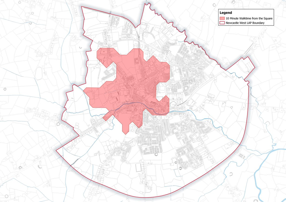
Figure 7.1: Newcastle West Walking Distances
Policy SMTP1 - Integration of Land Use and Transport: It is a policy of the Council to:
Support and facilitate the integration of land use and transportation policies for Newcastle West, as a means of reducing the impact on climate change. The Council will ensure the delivery of a sustainable compact settlement, which can be served by sustainable modes of transport with a focus on reducing the need to travel.
Policy SMTP2 - Promotion of Sustainable Patterns of Transport: It is a policy of the Council to:
Seek to implement in a positive manner, in cooperation with other relevant stakeholders and agencies, the policies of the NPF, RSES and the Department of Transport’s Active Travel publications, to encourage more sustainable patterns of travel and greater use of sustainable forms of transport in Newcastle West, including public transport, cycling and walking.
As part of the preparation of the Local Area Plan, Limerick City and Council commissioned the preparation of a Local Transport Plan (LTP) for Newcastle West. The objective of the plan is to provide a long term strategic integrated Local Transport Plan for the town, that incorporates all land transport modes and to inform the preparation of the Newcastle West Local Area Plan (LAP) 2023-2029.
The strategic aim of the LTP is to provide for the planning and delivery of transport infrastructure and services in the town over the period of the Limerick Development Plan 2022-2028, the Draft Newcastle West Local Area Plan 2023-2029, and beyond, which will:
-Co-ordinate transport and land use planning,
-Reduce the demand for travel and the reliance on the private car in favour of more sustainable forms of transport,
-Provide a safe and sustainable transport network,
-Identify strategic walking and cycling infrastructure to prioritise for funding.
The LTP examines all transport modes and how they interact. It has been prepared to make sure that movement and accessibility of all forms, across all modes are considered; The Local Transport Plan incorporates up to date land use zonings for the town and has been carried out in close collaboration with the preparation of this Plan.
Objective SMTO1 - Local Transport Plan: It is an objective of the Council to:
Implement the Local Transport Plan for Newcastle West and all actions/recommendations contained within, in particular Tables 4.1, 4.2 and 4.3. (See Volume 2)
In order to achieve more sustainable travel patterns, a significant focus on reducing car dependency and increasing permeability is required as promoted by higher-level spatial plans. Vehicles often dominate the streets and vehicle movement can be detrimental to vibrancy and livability of the town, as well as depleting public realm and creating safety issues for pedestrians and cyclists. Redesigning our streets to prioritise walking, cycling and other non-motorised wheel-based modes is just one crucial aspect of enabling and creating a modal shift from the private car, we also need to support individual citizens to make the switch to active travel through behavioural change projects and support initiatives.
CSO Census 2016 data outlines the number of commuters in individual electoral areas travelling for work, school or college. This information provides an insight into wider travel patterns for a particular location. The dominant mode of travel in Newcastle West is the car. 75% of residents travel to work, school or college, as a car or van driver or passenger. There are some options for public transport, with 0.7% using it as a mode of travel to work. In 2016, 997 commuters who lived in Newcastle West worked outside of the area, while 1,683 commuters travelled in for work. This resulted in a net flow of 686 commuters into Newcastle West. This is reflected in demand for car parking across the town. 19% of residents travel to school or college by bus, which demonstrates a good uptake of the school travel programme. School and college trips are important trips to consider when planning the movement plan. Similar to work trips, they occur daily during the week, they potentially are four trips to account for drop off and collection and involve a high amount of traffic converging on a small number of locations at the same time. Walking and cycling rates in Newcastle West are low, with 8.25% of trips being made on foot and 0.34% of trips being made by bicycle. This is compared to 13.5% walking and cycling to work in the southern region. This is despite 40% of trips to work, school or college for the residents of Newcastle West taking less than 15 minutes. The graphic in Figure 7.2 identifies the number of commuters travelling to and from the electoral areas adjoining Newcastle West.
The Limerick Development Plan 2022 – 2028 sets the following targets for the modal shift for Newcastle West. This is shown in Table 7.1 below.
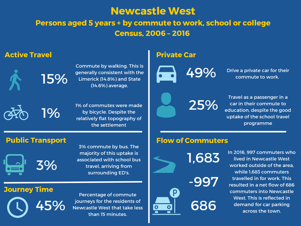
Figure 7.2: Persons aged 5 years + mode of commute to work, school or college in Newcastle West (CSO 2016 Census)

Table 7.1: Modal Share Targets
Source: Table 9: Mode Shift Targets for commute to work, school or college, by 2028 LDP 2022-2028
With the high levels of car dependency in Newcastle West, there are significant challenges with regard to promoting a modal shift away from the private car usage. However, the Draft Newcastle West Local Area Plan and LTP strives to reduce the reliance on the private car, by promoting and facilitating more sustainable modes of transport, based on the principles of the 10-minute town a compact settlement and the town-centre first approach. The Council will co-operate closely with other relevant agencies and stakeholders, including the NTA and TII to address modal shift targets as above.
7.4.1 Existing Public Transport Provision
Newcastle West is served by regular regional and local bus services, as shown in the table below. Local Link also provides less frequent services to Adare, Kilfinny, Ballingarry, Feenagh, Ballyhahill and Abbeyfeale to provide local services to the Newcastle West Desmond Complex. Bus stops are provided at two locations on the N21, one east of the town at the Longcourt House Hotel, with a bus stop for east and westbound services. Shelters are provided at these bus stops. The second bus stop location is on the west of Newcastle West on South Quay, also for east and westbound services. Local Link use a car park in the centre of Newcastle West. There are no dedicated bus stop facilitates within the town centre.
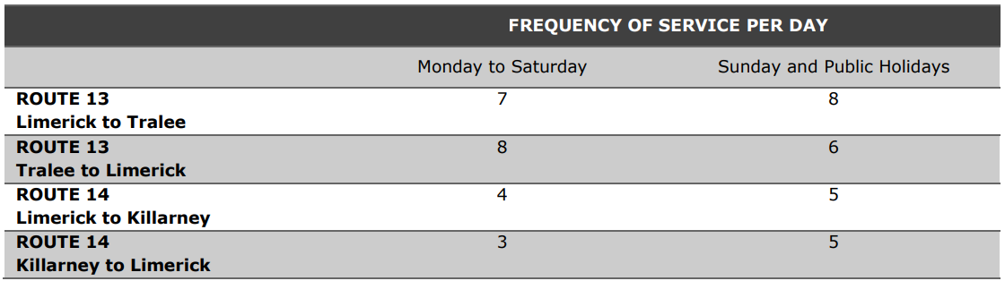
Table 7.2: Frequency of Bus Services at Newcastle West
Objective SMTO2 - Supporting Modal Split: It is an objective of the council to:
a) Encourage, promote and facilitate a modal shift towards more sustainable forms of transport in Newcastle West, including the Limerick Greenway.
b) Support and facilitate implementation of an integrated, multi-modal and accessible public transport network for Newcastle West and its hinterland.
7.5.1 Existing Walking/Cycling Infrastructure
Newcastle West has good provision of footpaths throughout the town centre and in the surrounding routes.
The NCWLTP recognises that there are a number of locations throughout Newcastle West where connectivity of the pedestrian network requires improvement. Safe and easy to use crossing locations improve accessibility for pedestrians and increase comfort levels for those walking. These locations include: Station Road and Churchtown Road junction, Bishop Street and Market Place junction and Sheehan’s Road.
There are notable pedestrian links within the town centre, including Bridewell Lane, which links the public car park with Bishop Street. Brewery Lane links Market Place with Maiden Street, but is not open to the public at this time. Nash’s Lane allows for vehicular traffic, but is predominantly used by pedestrians to access Aldi and the Demense from the town centre. Upgrading of these lanes will improve permeability through the town, increase walking and cycling rates and reduce dependency on the private car.
As well as providing a movement link for vehicular traffic, the N21 also provides an important east-west link for pedestrian movements. Residential, amenity and schools are located south of the N21, with the town centre and many services provided north of the N21. Consequently, crossing the N21 forms a significant link in the pedestrian network. Controlled crossing points are provided along the route at Sheehan’s Road, Bother Buí and Bridge Street. There is a notable lack of cycling infrastructure within the town, which the LTP seeks to address.
Newcastle West benefits from the recent development of the off-road 44km walkway/cycleway known as the Limerick Greenway – a former railway line re-purposed for active mobility and recreation. Part of the Greenway is located within the Draft LAP boundary and provides further opportunities for active mobility by walking and cycling.
Amenity walking in the town is provided for in the Demesne and the Limerick Greenway. The Demense is located on the west side of the town centre and can be accessed from The Square, west of Aldi and from Churchtown Road. It provides recreational playing fields, access to sports facilities, green spaces and walking routes. The connections between the Demense and the town centre and the interconnection of the Demense and the Greenway require improvement, the provision of which will be supported in this plan, as per the actions/recommendations shown in Tables 4.1, 4.2 and 4.3. (See Volume 2) of the Local Transport Plan (See Volume 2).
Objective SMTO3 - Walking and Cycling: It is an objective of the council to:
(a) Enhance the walking and cycling networks through the town within the lifetime of the Plan and seek to improve direct pedestrian linkages, cycle networks and infrastructure throughout the town and improve connectivity to the town centre and existing services.
(b) Incorporate Sustainable Travel measures in all new developments in the town.
(c) Support the progression of enhancing connectivity between the Limerick Greenway and the town centre by safe walkway/cycleway route, subject to the necessary environmental assessments.
(d) To develop a pedestrian and cycle route between the Greenway to the Demense and improve the linkage to the town centre.
(e) Facilitate school zone measures, including slow zones around the schools, and promote/facilitate active travel options for students to reduce the health and safety risks associated with traffic congestion, pollution and inactive lifestyles.
A national road and a number of strategic regional routes converge in Newcastle West, including the N21 National Primary Road, the R521 to Foynes, the R522 to Charleville and the R520 to Kilmallock. The strategic regional routes listed above are identified as strategic regional routes in the Limerick Development Plan 2022 – 2028.
The N21 National Primary Route connects Limerick and Kerry and plays an important role in the regions transport links. Transport Infrastructure Ireland (TII)’s traffic count data provides an Annual Average Daily Traffic (AADT) of in 10,710 2018, with 5.6% of this being HGV traffic. High flows of through traffic have effects on local traffic, with queues forming on the N21 to travel through Newcastle West, especially during times of high tourist activity, such as bank holidays. This also leads to difficultly for local traffic to travel around Newcastle West, as many journeys require crossing or joining the N21. The N21 is heavily congested particularly at peak periods.
The R521 to Foynes commences at the Square in Newcastle West and travels north to connect with the N69 at Foynes, providing a key north-south link in Limerick.
The R522 and R520 converge at the east of Newcastle West, linked to the N21 by way of a roundabout. The R522 links Charleville with Newcastle West, connecting Cork with east Limerick County. The R520 provides an east/west link between Newcastle West and Kilmallock and Ballingarry. All of these regional routes are also used by residents of Newcastle West’s hinterland to access the town centre. They also provide an important industry link between regional towns, carrying high levels of HGV traffic.
The R521 in the north of Newcastle West is connected to the N21 and R522 and R520 by local roads Station Road and Gortboy. With the exception of the roundabout at the N21 and R520, priority Stop controlled junctions are in place along the route.
Newcastle West has an extensive local road network that connects the residential, business, industry, retail, school and social services within the town. The local road network around the town generally accommodates footpaths on both sides. Town centre roads are narrow, particularly reflective of their historic origins.
The Plan will seek to safeguard the development and carrying capacity of the national road infrastructure along the existing N21. Development proposals which may affect national roads within or adjacent to the Plan boundary must have regard to the requirements of the Spatial Planning and National Roads Guidelines (DoECLG, 2012), the Traffic and Transport Assessment Guidelines (TII, 2014) and the Road Safety Audit Standards (TII, 2017). New development will be required to accord with policies of the Limerick Development Plan 2022 to 2028, which seeks to safeguard roads from development, which would compromise their safety, integrity or carrying capacity.
Objective SMTO4 – National and Regional Roads: It is an objective of the Council to:
- Protect the capacity of the national and regional road network from inappropriate development, having regard to all relevant Government guidance and Objective TR 041 Strategic Regional Roads of the Limerick Development Plan 2022-2028 and ensure development does not compromise the performance of the network or future improvements to the network. Road Safety Audits and Traffic Impact Assessments will be required to demonstrate implications of development proposals on the national and regional road network.
- Restrict advertising signage adjacent to the national road networks, in accordance with Section 3.8 of the Spatial Planning and National Roads Guidelines, 2012 and any subsequent replacement.
- Ensure new development proposals comply with Spatial Planning and National Roads Guidelines for Local Authorities (DoECLG, 2012), the Traffic and Transport Assessment Guidelines (TII, 2014), the Road Safety Audit Standards (TII, 2017) and safeguard the integrity, capacity and safety of national roads.
- Ensure new development does not comprise the strategic function of the N21 and ensure that all new development proposals accord with policies of the Limerick Development Plan.
- Adhere to the requirements of S.I. No. 140 of 2006 Environmental Noise Regulations by requesting the implementation of noise mitigation measures when introducing noise sensitive uses in the environs of existing and planned national roads.
- Ensure all developments protect and safeguard the capacity and efficiency of the drainage regimes of the regional and local network.
- Support the provisions set out in the 2020 DMURS Interim Advice Note – Covid-19 Pandemic Response.
- Transport infrastructure projects that are not already permitted or provided for by existing plans/programmes, shall be subject to the undertaking of feasibility assessment, taking into account planning need and the policies and objectives of the Draft Plan relating to sustainable mobility. Where feasibility is established, a Corridor and Route Selection Process will be undertaken, where relevant appropriate, in two stages: Stage 1 – Route Corridor Identification, Evaluation and Selection; and Stage 2 – Route Identification, Evaluation and Selection. New transport infrastructure will be considered subject to environmental constraints as identified in the SEA Environmental Report, including those related to habitats and potential impacts (e.g. disturbance from lighting). This will include minimising river crossings, avoiding sensitive habitats, not increasing barriers to flood waters and sustainable design and construction techniques.
7.6.1.1 N21
Limerick City and County Council is working in partnership with Transport Infrastructure Ireland (TII) and the Department of Transport to develop a scheme to relieve congestion on the N21 Limerick to Tralee Road through Newcastle West. This project is called the N21 Newcastle West Road Scheme. This is an important project to enhance regional connectivity and to improve road safety.
Subject to funding, the design process will be developed in stages, with opportunities for the public to participate in the decision-making at key stages. The bypass will have a significant impact on alleviating some of this through-traffic through Newcastle West.
Policy SMTP3 - Sustainable Mobility and Regional Accessibility: It is a policy of the Council to:
- Support the progression of the N21 Newcastle West Road Scheme (as already provided by the Limerick Development Plan 2022-2028, including Objective TR O31), and associated linkage into the town centre, to provide improved regional connectivity and ensure future development proposals do not compromise the development of this scheme.
- Maintain the strategic function, capacity and safety of the national roads network, including planning for future capacity enhancements.
- Support enhanced regional accessibility and to relieve congestion on the N21 Limerick to Tralee Road through Newcastle West in accordance with the National Strategic Outcomes of the National Planning Framework and the Regional Spatial and Economic Strategy for the Southern Region.
Contents
Observations
Observations
Good Afternoon Karen,
You may recall our discussions at LAP meeting in Newcastle West on May 25th last. You suggested that I should make representations on the following:-
Red Door...
Indicative Link Road From Woodfield Entrance To Knockane Will Be Too Dangerous
As a long term resident of Woodfield Green, I am very concerned that the proposed indicative link road from our estate entrance to Knockane will make our housing estate very busy and dangerous. My 4...