Chapter 2 - Strategic Context and Town Profile
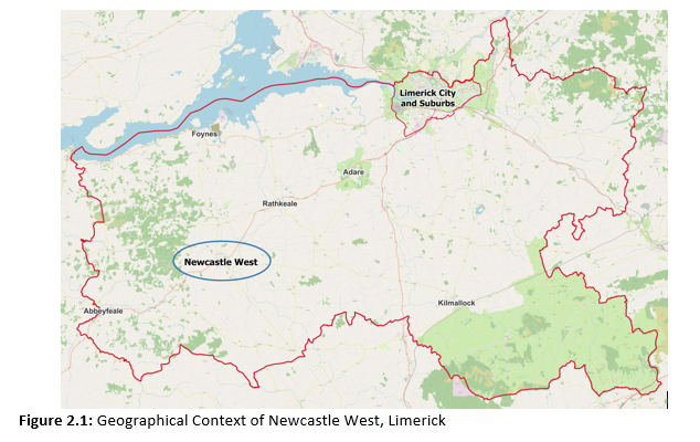
Newcastle West is the largest settlement in Limerick outside of Limerick City. It is designated as a Key Town in the Regional Spatial and Economic Strategy (RSES) for the Southern Region. Historically a town of fairs and butter markets, Newcastle West is now a large centre of employment with a strong business and enterprise culture.
Newcastle West located approximately 45Km south west of Limerick City on a relatively flat plain at the foothills of the Mullaghareirks mountains approximately 4km to the west of the town. The Arra River rises in Knockanimpuha and flows easterly through Newcastle West adjacent to the N21 on North Quay. The Dooally River rises in Ballynabearna to the north of the town, and flows south easterly to join the River Arra upstream of the town. On the north east boundary of the town the River Daar flows.
The national route, the N21 Limerick to Tralee road, traverses the town and strategic regional roads extend northwards to Ardagh and Foynes (R521), southeast to Dromcollogher and Charleville (R522), and eastward to Ballingarry and Kilmallock (R520).
The Limerick Development Plan promotes Newcastle West as a key Town and secondary development centre to the Limerick City Metropolitan Area for population growth. For Newcastle West to fulfil this role identified in the Limerick Development Plan 2020-2028 the town requires consolidation of land use, catch–up in investment in services, infrastructure, sustainable transport options, amenities and local employment balanced with housing delivery.
 2.2 Demographic and Socio-economic profile
The principal demographic trends for Newcastle West as set out in CSO Census data are outlined in the following sections. This data is significant in terms of the demands for service provision such as schools and childcare facilities, the provision of housing, health-care, employment opportunities and future accommodation including providing suitable independent and assisted living accommodation for older people as well as availability of labour force, standards of education/training attained and disposable income.
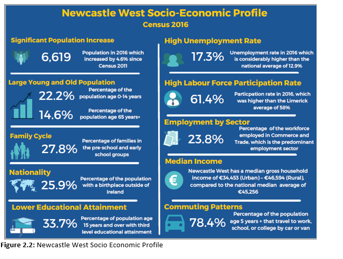
Newcastle West is the largest town in County Limerick, with the 2016 Census results showing that the total population of Newcastle West was 6,619 persons in 2016. This represented an increase of 4.6% (292 persons) since 2011, which outperformed the County and State averages for the same period (Table 2.1 below).
|
2011 (Number) |
2016 (Number) |
Actual Change 2011-2016 |
% Change 2011-2016 |
|
|
Newcastle West |
6,327 |
6,619 |
292 |
4.6% |
|
Limerick |
191,809 |
194,899 |
3,090 |
1.6% |
|
State |
4,588,252 |
4,761,865 |
173,613 |
3.8% |
Table 2.1: Population Growth 2011-2016
Source: CSO Census 2016
In terms of population structure, 22.2% of the population was under 15 years, which was higher than both the average for the county (20.3%) and nationally (21.1%). However, only 9.2% of the town’s population were age 15-24 years which was significantly lower than in Limerick (13.3%) and nationally (12.1%). Some 54.1% were aged 25-64 years, which was a very favourable trend for the town as it was higher than both the county and State averages, and impacts labour supply. Newcastle West has a larger cohort of the older population age 65 years and over (14.6%) relative to Limerick and national trends, thereby creating a demand for services to support the needs of an ageing population.
In 2016, Newcastle West had the largest daytime working population in the County with 2413 workers.
The labour force participation rate, which indicates the proportion of the population at work and those available for work, was recorded at 61.4% in Newcastle West. This is very favourable for the town as it is similar to the national labour force participation rate and higher than the average for Limerick of 58%. The predominant sector for employment in Newcastle West is Commerce and Trade with 23.8% of the population employed in this sector. This is closely followed by the Professional Services sector, which contributes to 21.7% of the town’s employment. This reflects the importance of the town as a commercial and service centre and a vital centre of regional economic activity. Manufacturing Industries is the third largest employer in the town (19.5%) with considerably more males than females employed in this sector.
In Newcastle West, important stages in the family cycle, include the pre-school and early school groups, accounting for 27.8% of all families. Families in the empty nester and retired stages account for 17.3% of all families in Newcastle West.
These trends in the family cycle will require additional services such as healthcare, options for the downsizing of dwellings, and independent/assisted living for older people and pressure on childcare and school enrolments.
Newcastle West has a median gross household income of €34,453 (NCW Urban) – 46,594 (NCW Rural). The national median average is €45,256.
It is most likely that Newcastle West was founded by the Geraldines. After the defeat of the Geraldines at the end of the 16th century the town and surrounding lands were forfeit to the crown. The Desmond Roll (1583) gives the first full account of Newcastle West mentioning at least two mills, street names and gardens. Despite these references, however, the medieval street pattern is unknown. In 1591, the town was granted to Sir W. Courtenay and its subsequent development was heavily influenced by that family.
Agriculture was a source of economic prosperity in Newcastle West from the 17th Century onwards. The town provided an important service through its weekly markets and various annual fairs. A 1709 survey shows the Square and the modern street pattern well established presumably as a result of landlord planning. From the 1700s onwards the town began to expand into the outlying areas, again mainly due to landlord improvements. The Square was mostly a residential area in the 17th and 18th centuries. The River Arra was realigned and New Quay (North Quay) was formed.
Lord Courtenay built the first recorded school house in Newcastle in 1720 (Cussen 1979, 3)1. He also built a church to the south of the castle in 1777. Lewis (1837, vol. II, 425) refers to the state of industry in the early 19th century, ‘There are several establishments in the town for dying woollens, also a large ale and beer brewery, and a great number of shoe and brogue makers, a bleaching establishment in the immediate vicinity, which occupies 8 acres and gives work to a number of men’2. Most of the standing buildings in the Square are nineteenth century in date (Cussen 1990, 42)3. St. Ita’s Hospital (1839), the Court House (1842), the Sisters of Mercy Convent (1850) and the Protestant School (1850) were all established in the 19th century. The Newcastle West Junction of the North Kerry railway was opened in 1878 (Murray & McNeill 1976, 117)4. Up to 1860 the river Beesoms flowed openly down the middle of Bishop Street. The river was covered over during the 1860’s and the street line was extended (Cussen 1990, 45).
By the 20th Century, development spread along arterial roads. The late 20th Century saw development spreading mostly on the outskirts of the town along the Limerick to Tralee road, known as the N21.
2.4 Emerging Opportunities and Development Challenges
There are challenges and opportunities that Newcastle West must address. Challenges include, commercial vacancy and under-use of land/buildings. In addition to meeting the needs of the emerging population profile from young families to an aging population and adapting to climate change.
Methods to address these challenges can be best achieved through the sustainable and compact growth of Newcastle West, with emphasis on the regeneration and repopulation of the town centre and built- up areas. This approach focuses on maximizing the use of infill, vacant and underutilized sites and of buildings that are suitable and capable of re- use to provide housing, amenities, jobs and services. The names of several of the existing housing estates in Newcastle West, as shown if Figure 2.3 below Have a historical context.
1. Cussen, R. 1979 ‘Early Schools in Newcastle’, Journal of the Newcastle West Historical Society, 3-15.
2. Lewis, S. 1837 A topographical dictionary of Ireland, Vol II, London.
3. Cussen, R. 1990 ‘Newcastle: The face of the town’, Journal of the Newcastle West Historical Society, 44-7.
4. Murray, K.A. & McNeill, D.B. 1976 The Great Southern & Western Railway, Dublin.
2.4 Emerging Opportunities and Development Challenges
There are challenges and opportunities that Newcastle West must address. Challenges include, commercial vacancy and under-use of land/buildings. In addition to meeting the needs of the emerging population profile from young families to an aging population and adapting to climate change.
Methods to address these challenges can be best achieved through the sustainable and compact growth of Newcastle West, with emphasis on the regeneration and repopulation of the town centre and built- up areas. This approach focuses on maximizing the use of infill, vacant and underutilized sites and of buildings that are suitable and capable of re- use to provide housing, amenities, jobs and services. The names of several of the existing housing estates in Newcastle West, as shown if Figure 2.3 below Have a historical context.

The Plan will focus on the following Key Challenges and Emerging Opportunities:
Compact Growth – The LAP shall adhere to the targets set out in the core strategy, and Settlement Strategy and Housing Need and Demand Assessment (HNDA) of the Limerick Development Plan 2022-2028.
Town Centre First – A successful town centre, includes a retail sector, which plays a crucial role in terms of economic growth and development. The LAP promotes stimulating regeneration and renewal of the town centre, thereby contributing to overall economic viability and delivery of high-quality public realm and built environment.
Opportunity Sites – Newcastle West has a number of sites with potential opportunities for compact growth and environmental improvement.
Economic Activity - Ensuring the enhancement of Newcastle West’s manufacturing base in healthcare, joinery, food, beverages, and machinery. Conditions for the creation of enterprise and innovation are embraced and developed to encourage and facilitate a diversity of employment opportunities, promote inward investment and commerce. The Atlantic Economic Corridor (western seaboard) has the potential to act as a key enabler for the regional growth objectives of the National Planning Framework.
Tourism Potential - Newcastle West has significant tourism potential; it is home to the Desmond Castle and Banqueting Hall located in the centre of the town, the historic town square, an obvious historical landmark and adjacent Castle Demesne. Following the old Limerick to Kerry railway line, the Limerick Greenway seamlessly links the West Limerick landscape with Newcastle West and some of the County’s most historic sites.
Integration of Land Use and Transport - Co-ordination of transport and land use planning plays a pivotal role in the sustainable development of the local economy. Where and how we build our residential and work environments and supporting transport infrastructure including roads, footpaths, cycle ways, buses and rail infrastructure impacts, is fundamental for sustainable communities, climate action and quality of life considerations. The improvement of regional connectivity, linking together the major urban areas to allow the Atlantic Economic Corridor to achieve its potential, is a major priority.
Flooding - Flood risk issues are an important consideration in the preparation of the LAP, particularly in zoning lands for appropriate uses in flood risk areas.
Environment and Climate Change - Delivery of sustainable growth and preserving the environmental assets of the surrounding area is a key consideration of the LAP, which includes delivering positive environmental outcomes, including for water and climate change.
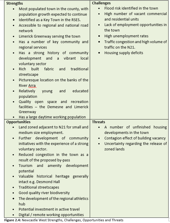
The SCOT Analysis is a study of the Strengths, Challenges, Opportunities and Threats that exist within Newcastle West. Such analysis identifies both the key issues in Newcastle West and the opportunities that exist to address these issues. This SCOT Analysis has helped inform the overall Development Strategy for the Plan Area.
1. Cussen, R. 1979 ‘Early Schools in Newcastle’, Journal of the Newcastle West Historical Society, 3-15.
2. Lewis, S. 1837 A topographical dictionary of Ireland, Vol II, London.
3. Cussen, R. 1990 ‘Newcastle: The face of the town’, Journal of the Newcastle West Historical Society, 44-7.
4. Murray, K.A. & McNeill, D.B. 1976 The Great Southern & Western Railway, Dublin.