Chapter 2 - The Vision and Core Development Strategy
2.1 The Planning Vision and Goal for Kilmallock
Having considered the development of Kilmallock since the adoption of the 2009 LAP, the vision for the town is revised, but is still cognisant of the critical importance of the historic town fabric to Kilmallock’s identity and opportunities. It is necessary to capitalise and broaden Kilmallock’s opportunities for the betterment of the town, and its competitiveness to sustain a good quality of life, attract business interest, investment and visitors, which will have the effect of creating a better tourism product. The core strategy consists of the long-term vision for the town and will act as an important stepping-stone towards realising that longer-term vision.
The vision for Kilmallock is as follows:
Kilmallock will be a resilient and vibrant town, competitive to attract inward investment, sustaining a diverse community with opportunities for quality housing, education, enterprise and employment, whilst safeguarding Kilmallock’s natural and built heritage for future generations. It will continue to function as a key centre of economic, social, cultural activity in South Limerick.
The goal of the proposed Kilmallock Plan 2019 – 2025 is to:
- Ensure that the land use zoning and the objectives of the proposed LAP guides development appropriately in terms of scale and location in the town, to sustain a competitive living, business and tourist destination, whilst capitalising on the existing built, natural and cultural heritage of the town, and
- Capitalise recent infrastructural investments in the town and seek further opportunities for investment to sustain the future development of the town and its hinterland.
The vision and goal are guided by national planning guidance documents and policy documents, in particular the NPF, and the hierarchy of spatial plans outlined in Figure 1.1. The parent planning document to the proposed Kilmallock Local Area Plan is the Limerick County Development Plan 2010 – 2016(as extended). All objectives of this LAP must align with the core strategy and objectives of the Limerick County Development Plan 2010 – 2016(as extended). The Development Management guidelines for applicants seeking planning permission in Kilmallock are contained in the current Limerick County Development Plan and any subsequent review of this Plan.
2.2 Translating the core strategy into the proposed LAP policies and objectives
To translate the vision and goal, into a localised plan for Kilmallock’s progression in terms of its population, economy, heritage assets, and sustainability, all policies and objectives are underpinned by the core principles of:
- A compact, green, quality, connected town seeking smart solutions such as green travel modes, digital fibre and modern technology
- A prosperous, enterprising, creative, innovative town in terms of modern employment and cultural opportunities, and
- A resilient town with a sustainable and diverse community.
- At town that protects and enhances its heritage resources.
Planning applications for new development proposals will be assessed according to the land use zones and objectives of this plan.
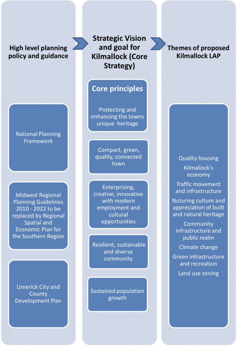
Refer to Figure 2.1 below outlining the process of deriving policy and objectives of the proposed LAP.
Figure 2.1 Deriving the policies and objectives of the proposed Kilmallock LAP
2.3 Population targets
The National Planning Framework has been published for Ireland (February 2018) and will govern where development takes place in the country until 2040. The plan will be implemented through the Regional Spatial and Economic Strategies and presently, the strategy for the Southern Region is currently being prepared. In the absence of the adopted RSES for the Southern Region, population growth for Limerick has been calculated based on the NPF strategy and Implementation Road Map.
Limerick City & County Council have considered the population growth of the City and County. The anticipated population in Kilmallock expects the town’s population to reach 3,169 people by 2040. Applying these targets to the new Kilmallock Plan there is an anticipated growth of an additional 563 persons by 2025. This equates to 62.5 persons per annum over nine years (2016 – 2025).
Table 2.1 Population growth based on draft RSES of the Southern Region
|
Census 2016 |
Population increase to 2025 |
Persons per annum |
Total population 2025 |
% change 2016 - 2025 |
|
1668 |
563 |
62.5 |
2,231 |
+33.7 |
Such a scale of growth is considered appropriate given the towns strategic location relative to Limerick and Cork, the availability of serviced lands and the range of services available to sustain a growing population. It is noteworthy that objective SS01 of the CDP requires the town to grow sequentially from the town centre, maintaining a compact urban settlement and avoiding leap-frogging of development. Proposals for infill development, particularly in town core are encouraged and are necessary given the level of vacancy in the town. The NPF seeks that at least 30% of all new homes nationally are provided within the built-up footprint of existing settlements. Additional population growth in Kilmallock will lead to increased service demand and a criterial mass for the provision of additional services. Based on the above the anticipated amount of residentially zoned lands required in the new Local Area Plan is broken down as follows:
1500 population over the next 24 years resulting in:
- 62.5 additional people in Kilmallock per annum
- 563 additional people in Kilmallock over the plan period (2016-2025)
- 321 houses required (on the basis of a household size of 2.5)
- 15.3 hectares of residential lands required for Residential Development Areas(based on a density of 22 units per hectare)
- 6.42 hectares of Serviced Sites lands(based on a density of 10 units per hectare)
- Add headroom of 25% as set out in the National Planning Framework Implementation Road Map 2018 for Limerick = 15.3 hectares for Residential Development Area, and 7.33 hectares for Serviced Sites.
Total amount of land required for residential development 22.63 hectares of land.
Note: It is anticipated that 80% of new residential development will take place in the form of residential estates with the other 20% accounted for as Serviced Sites.
It should be noted that the above figures does not take account of the number of vacant residential units in Kilmallock town and the number of persons on the Social Housing waiting list for this town. This is set out in the Draft RSES for the Southern Region. It states that “Additional housing will also be required to cater for existing population requirements including social housing demand, renewal/upgrading and replacement of older and poor-quality stock, formation of smaller families, increase ageing population with resultant requirement for additional housing responses.” Section 2.4 underneath and Tables 2.2 and 2.3 carry out this assessment.
Consideration has been given to the number of people on the waiting list for Social Housing in Kilmallock. The RSES for the Southern Regions requires consideration to be given to the Social Housing waiting list. This figure stands at 322 people and has been incorporated as an additional land zoning requirement for Kilmallock town. This detail is set out in Table 2.2 and 2.3 underneath.
2.4 Land zoning requirements
According to the assessment carried out in Section 2.3, there is a requirement for 22.63 hectares of lands needed for residential use over the plan period. The plan proposes to introduce a phasing programme, which will be supported by an Objective in Chapter 3 Quality Housing, whereby 50% of the lands in Phase 1 must be developed before development can proceed on lands identified in Phase 2.
A detailed serviced lands assessment matrix was compiled as part of the plan preparation process in line with the requirements of the NPF to establish the suitability of the land for development within the plan boundary. This has been included in the plan by way of an Appendix (Appendix 4). All the lands zoned for residential development phase 1 have been zoned on the basis that adequate services are available to facilitate the development of each of the sites. Two further issues for consideration in assessing the land zoning requirements are residential vacancy and the Social Housing waiting list for the town. The assessment of vacancy in the town has identified 33 vacant residential units and these have been included in Table 4 below to calculate zoning requirements in the town.
Table 2.2 Residential units required to accommodate projected population growth to 2025
|
A |
B |
C |
D |
E |
F |
H |
I |
|
Pop increase |
Persons requiring social housing Jan 2019 |
Total persons requiring housing
(A+B)
|
GeoDirectory vacant residential units* |
Potential persons per Geodirectoy vacant units |
Housing units required
C - E/2.5 average household size – vacant units |
Total new residential units required
F x 80% |
Total Serviced site units required
F x 20% |
|
563 |
322 |
885 |
33 |
83 |
321 |
257 |
64 |
Table 2.3 Residential zoned land requirements based on Table 2.2 above
|
A |
B |
C |
D |
E |
F |
|
Total units required |
New residential units required |
Hectares for new residential at 22 units per ha + 25% headroom
B/22 + 25% |
Serviced Sites required |
Hectares for Serviced site units required at 10 per ha + 25% headroom
D/10 units per ha + 25% |
Total ha required
C + E |
|
321 |
257 |
15 |
64 |
7 |
22 |